Map
1 2017-11-18T07:50:56-08:00 Angela Schöpke a9b85985047875065a895f217f6d9371b9e08ba7 25325 8 google_maps 2017-12-09T16:32:53-08:00 Angela Schöpke a9b85985047875065a895f217f6d9371b9e08ba7Introduction | Context | Timeline | Map | All Archive Items | Resources
Each selected item in this collection includes one or more associated Cartesian coordinate(s) in its metadata, which have been plotted in the geospatial visualization featured on this page. These coordinates describe where the item was produced or processed during its active life. The map provides an overview of the national and international scope of memory associated with the Polar Bear Expedition exhumation and repatriation efforts.
Items are represented on the map by a red marker. By clicking on any given marker, you may view the thumbnail, title and description of the item associated with that marker. Click on the title of the selected item to navigate to the full item description and view.
This page has paths:
- 1 2017-11-28T15:54:29-08:00 Angela Schöpke a9b85985047875065a895f217f6d9371b9e08ba7 Table of Contents Angela Schöpke 1 toc 2017-11-28T15:54:29-08:00 Angela Schöpke a9b85985047875065a895f217f6d9371b9e08ba7
Contents of this tag:
- 1 2017-11-10T04:08:30-08:00 Natalia Holtzman 3bc8196281034c0edcbedc5566da15e84a149850 Dedication to John L. Dalian (Jack) - Commander of Polar Bear Post 436 (typed) 12 The text of a dedication to John J. Dalian (Jack), Commander of Polar Bear Post 436, from “the Officers and Members” of that Post. They write that Dalian “unsparingly and unselfishly gave of his time and effort for sick and needy comrades and their families and particularly for the benefit of the orphans in the V.F.W. home…” media/dedication-to-john-dalian.jpg plain 2017-12-15T11:03:53-08:00 Michael J. Macalla papers, Bentley Historical Library, University of Michigan May 13, 1955 Text of dedication (typed) 10000010 John L. Dalian (Jack) Statement of rights from archival material host organization, Bentley Historical Library: “Copyright to this material has not been transferred to the Bentley Historical Library, University of Michigan. Complying with copyright law is ultimately the responsibility of the author, producer and publisher. To the extent that the Bentley Historical Library possesses rights to this material, you are granted permission to publish or use images/quote one time only in the work described above.” This archive uses these materials under the above premises and in consideration of Fair Use principles. 42.331429, -83.045753 Dedication to John L. Dalian (Jack) - Commander of Polar Bear Post 436 (typed), Box 1, Folder 5, Item 22, Michael J. Macalla Papers, 1918-1956, Bentley Historical Library, University of Michigan. https://quod.lib.umich.edu/p/polar/851792.0005.022/1?rgn=full+text;view=image The collection was donated by Michael Macalla, of Detroit, Michigan, in 1965 (Donor no.: 4274) Natalia Holtzman 11/2/17 IN HONORED MEMORY OF JOHN L. DALIAN (JACK) TO OUR ESTEEMED FRIEND, COMRADE, AND PAST COMMANDER OF POLAR BEAR POST 436, V.F.W., WHO UNSPARINGLY AND UNSELFISHLY GAVE OF HIS TIME AND EFFORT FOR SICK AND NEEDY COMRADES AND THEIR FAMILIES AND PARTICULARLY FOR THE BENEFIT OF THE ORPHANS IN THE V.F.W. NATIONAL HOME IN WHOSE HAPPINESS HE BELIEVED AND PRACTICED THE TEACHING OF OUR LORD WHEN HE SAID: “SUFFER THE LITTLE CHILDREN TO COME UNTO ME, AND FORBID THEM NOT; FOR OF SUCH IS THE KINGDOM OF HEAVEN” FROM THE OFFICERS AND MEMBERS OF THE POLAR BEAR POST 436 V.F.W. DATED: MAY 13, 1955 Natalia Holtzman 3bc8196281034c0edcbedc5566da15e84a149850
- 1 2017-11-09T19:51:20-08:00 Angela Schöpke a9b85985047875065a895f217f6d9371b9e08ba7 Roster, 339th Infantry, Group 145, July 6, 1919 9 This is a roster of the 339th Infantry, Group 145 stationed in Archangel, Russia. media/PBE_Box1_Folder1_Item7.jpg plain 2017-12-15T09:55:13-08:00 Michael J. Macalla papers, Bentley Historical Library, University of Michigan 07/06/1919 Official Document 10000056 Statement of rights from archival material host organization, Bentley Historical Library: “Copyright to this material has not been transferred to the Bentley Historical Library, University of Michigan. Complying with copyright law is ultimately the responsibility of the author, producer and publisher. To the extent that the Bentley Historical Library possesses rights to this material, you are granted permission to publish or use images/quote one time only in the work described above.” This archive uses these materials under the above premises and in consideration of Fair Use principles. 64.54725069999999, 40.56015530000002 Roster, 339th Infantry, Group 145, July 6, 1919, Box 1, Folder 1, Item 7, Michael J. Macalla Papers, 1918-1956, Bentley Historical Library, University of Michigan. https://quod.lib.umich.edu/p/polar/851792.0001.007/1?rgn=full+text;view=image The collection was donated by Michael Macalla, of Detroit, Michigan, in 1965 (Donor no.: 4274). Angela Schöpke October 27, 2017 339th Infantry Group 145 July 6, 1919 Lindeman Otto E Cahpchunk George Callas John VanDolaan Chester A Mrock Fred Okaroki Frank J Rybicki Anthony Robertson Charles B Pinnow Charles G Swiskey Pani P Moiver Russell A Leavey Michael Olschefski Frank E Quarters Joseph Pettinelli Enrico Markiecki Anthony Ellis William A Kelley John A Klema Richard J Hoyt Stephen J Natalia Holtzman 3bc8196281034c0edcbedc5566da15e84a149850
- 1 2017-11-09T21:15:03-08:00 Angela Schöpke a9b85985047875065a895f217f6d9371b9e08ba7 "Quoth the Russian: 'Harashaw'" poem, by R.S. (reprint from American Sentinel, Dec.31, 1918) & "Ode to the Shackleton Boot" by E.J.H. (American Sentinel, Dec.24, 1918) 9 The first page is a reprint of a poem written by R.S., originally published in the American Sentinel (a weekly journal “DEVOTED TO. The defense of American Institutions, the preservation of the United States Constitution as it is, so far as regards religion or religious tests, and the maintenance of human rights both civil and religious.”). The poem describes what seems to be the author’s experience on the Russian Bakaritza shore requesting that a boatman row him across a body of water as quickly as possible in order that he may make his meeting. The boatman does not assist him and repeats the phrase “Harashaw”. The poem ends with R.S. pushing the boatman, rowing away himself, and looking back on the boatman cleaning himself of mud. This poem seems to make some statement about U.S.-Russian relations, or perhaps a soldier’s relationship with Russians at the time of the poem’s writing. The second page is a reprint of a poem written by E.J.H., originally published in the American Sentinel. The poem describes what seems to be a metaphor for the author’s stumbling search through the snows of Russia for some promised but elusive treasure (“Shackleton boot”)of some kind. The poem concludes with a sense of desperation and disillusionment that the treasure does not exist. media/PBE_Box1_Folder1_Item11.pdf plain 2017-12-15T09:57:51-08:00 Michael J. Macalla papers, Bentley Historical Library, University of Michigan 12/31/1918 - 12/24/1918 Publication 1000054 R.S. (soldier, poet); E.J.H. (soldier, poet) Statement of rights from archival material host organization, Bentley Historical Library: “Copyright to this material has not been transferred to the Bentley Historical Library, University of Michigan. Complying with copyright law is ultimately the responsibility of the author, producer and publisher. To the extent that the Bentley Historical Library possesses rights to this material, you are granted permission to publish or use images/quote one time only in the work described above.” This archive uses these materials under the above premises and in consideration of Fair Use principles. 38.9778882, -77.0074765 "Quoth the Russian: 'Harashaw'" poem, by R.S. (reprint from American Sentinel, Dec.31, 1918) & "Ode to the Shackleton Boot" by E.J.H. (American Sentinel, Dec.24, 1918), Box 1, Folder 1, Item 11, Michael J. Macalla Papers, 1918-1956, Bentley Historical Library, University of Michigan. https://quod.lib.umich.edu/p/polar/851792.0001.011/1?rgn=full+text;view=image The collection was donated by Michael Macalla, of Detroit, Michigan, in 1965 (Donor no.: 4274). Angela Schöpke October 27, 2017 QUOTH THE RUSSIAN: "HARASHAW” Once upon a morning dreary, I was standing, cold and weary Waiting for a Tug or Ferry, On the Bakaritza shore. There was little more afloat than one small craft with Russian boatman - "Do not play I cried "the boat, man; You must quickly row me o’er." Clear, indeed, he had the leisure, When I shouted "Row me o’er" Quoth the Russian "Harashaw". "Quickly", said I "time is fleeting. Quickly, lest I miss the meeting. Roubles fifty I will pay thee, If you get me there by four". Signal of agreement made he; Not a moment longer stayed he Wasting words. I was afraid he might ask three roubles more. He appeared a sluggish fellow - Never asking roubles more, Answering merely "Harashaw". Not a movement made he, lonely sitting in his boat spoke only That one word, although to move him I did threaten and implore When all weary of entreating - Cuss-words tired of repeating, I arranged for his unseating - With the heavy starboard oar. Deep he sank into the river When I thrust him with that oar. (Rising, quoth he "Harashaw".) Thankful for the stillness broken By reply so aptly spoken, In the boat vacated jumping, I rowed off the Smolny shore. Close behind I saw him standing On the Bakaritza Landing To his injuries attending, Wiping off the mud and gore. Bruised and dripping, I could hear him, Busy with the mud and gore, Softly murmuring "Harashaw". R.S Reprint from American Sentinel December 31, 1918 Natalia Holtzman 3bc8196281034c0edcbedc5566da15e84a149850
- 1 2017-11-28T12:37:33-08:00 Angela Schöpke a9b85985047875065a895f217f6d9371b9e08ba7 Passport, Michael Macalla [Page 8] 9 Michael Macalla’s Passport, Page 8 - Visas for Finland and Sweden. media/PBE_Box1_Folder2_Item20i.jpg plain 2017-12-15T10:49:08-08:00 Michael J. Macalla papers, Bentley Historical Library, University of Michigan. 07/01/1929 Official Document, Travel Document 10000041 U.S. Department of State Statement of rights from archival material host organization, Bentley Historical Library: “Copyright to this material has not been transferred to the Bentley Historical Library, University of Michigan. Complying with copyright law is ultimately the responsibility of the author, producer and publisher. To the extent that the Bentley Historical Library possesses rights to this material, you are granted permission to publish or use images/quote one time only in the work described above.” This archive uses these materials under the above premises and in consideration of Fair Use principles. 59.94358889999999, 30.35235990000001 60.1681167,24.95443899999998 "Passport, Michael Macalla," Box 1, Folder 2, Item 20, Michael J. Macalla Papers, 1918-1956, Bentley Historical Library, University of Michigan. https://quod.lib.umich.edu/p/polar/851792.0002.020/8?page=root;rgn=full+text;size=100;view=image The collection was donated by Michael Macalla, of Detroit, Michigan, in 1965 (Donor no.: 4274). Angela Schöpke 10/27/2017 Natalia Holtzman 3bc8196281034c0edcbedc5566da15e84a149850
- 1 2017-11-10T04:04:17-08:00 Natalia Holtzman 3bc8196281034c0edcbedc5566da15e84a149850 Speech for dedication of the Polar Bear Room 8 Text of a speech by an unnamed speaker (Macalla himself?) who calls on “Judge McKenzie” to provide “a brief history of the expedition in which the Polar Bears took part.” The occasion is the dedication of the Polar Bear Room but this particular speech is primarily an introduction to Judge McKenzie. media/pb-room-dedication-speech.jpg plain 2017-12-15T10:58:59-08:00 Michael J. Macalla papers, Bentley Historical Library, University of Michigan Text of speech (typed) 10000057 Polar Bear Room, Judge McKenzie Statement of rights from archival material host organization, Bentley Historical Library: “Copyright to this material has not been transferred to the Bentley Historical Library, University of Michigan. Complying with copyright law is ultimately the responsibility of the author, producer and publisher. To the extent that the Bentley Historical Library possesses rights to this material, you are granted permission to publish or use images/quote one time only in the work described above.” This archive uses these materials under the above premises and in consideration of Fair Use principles. 42.327021, -83.0456054 Speech for dedication of the Polar Bear Room, Box 1, Folder 5, Item 14, Michael J. Macalla Papers, 1918-1956, Bentley Historical Library, University of Michigan. https://quod.lib.umich.edu/p/polar/851792.0005.014/1?rgn=full+text;view=image The collection was donated by Michael Macalla, of Detroit, Michigan, in 1965 (Donor no.: 4274) Natalia Holtzman 11/2/17 Distinguished guests, Ladies and Gentlemen; and my comrades We are gathered here tonight in a ceremony to dedicate this room in honor of Detroit's own Polar Bears who fought the Bolsheviks in North Russia, in World War I. Without further ado we will begin the ceremony by asking [blank] to the deliver the invocation. For the benefit of our friends and relatives who are not familiar with the history of the organization, I'll call upon Judge McKenzie, Referee in Bankruptcy, of the U. S. District Court, to give us a brief history of the expedition in which the Polar Bears took part. . . . . . . . .Judge McKenzie. Ladies and Gentlemen, it is now my pleasure to introduce to you a gentleman who has had a varied career as a public servant, having served the public as assistant Prosecutar, assistant attorney general, City Corporation Counsel and is presently Judge of the Recorder's Court. In addition to the offices he has held, he has also served as a member of the Memorial Hall Commission for the past 20 years. This Commission has authority and direction over the entire Civic Center Area, which covers an area from Randolph Street, on the east, to Thrid Street on the west, and South of Jefferson to the River, Besides the veterans Memorial Building. Ladies and Gentlemen, I now present to you Judge F. G. Schemanske, Vice-President of the Memorial Hall Commission, and my boss if you please, who will make the presentation.........Judge Schemanske. Natalia Holtzman 3bc8196281034c0edcbedc5566da15e84a149850
- 1 2017-11-09T21:20:02-08:00 Angela Schöpke a9b85985047875065a895f217f6d9371b9e08ba7 Newspaper article, includes photographs 8 This is an article with photographs originally published in The Democrat and Chronicle Sunday Magazine. The article reflects on what it was like for American soldiers in Russia at the time of the Polar Bear Expedition, discussing daily life (food, prices of goods, entertainment, cultural interactions among Expedition members, other Allied troop members, and Russians), the unfolding of the Expedition’s work (begun as railroad work in support of the Russians’ railroad system, but turned into violent altercations with Bolsheviks that tried to use the railway for their own purposes - reflection that perhaps the Bolsheviks sought to draw Germans into their territory to defeat them). The article finishes with a reflection on the idea that the Expedition is often forgotten as having taken place. media/PBE_Box1_Folder1_Item12.pdf plain 2017-12-15T10:01:26-08:00 Michael J. Macalla papers, Bentley Historical Library, University of Michigan 08/31/1941 Publication, News Clipping 1000027 Lester Mathews (Journalist), The Democrat and Chronicle Sunday Magazine Statement of rights from archival material host organization, Bentley Historical Library: “Copyright to this material has not been transferred to the Bentley Historical Library, University of Michigan. Complying with copyright law is ultimately the responsibility of the author, producer and publisher. To the extent that the Bentley Historical Library possesses rights to this material, you are granted permission to publish or use images/quote one time only in the work described above.” This archive uses these materials under the above premises and in consideration of Fair Use principles. 43.16103, -77.6109219 Newspaper article, includes photographs, Box 1, Folder 1, Item 12, Michael J. Macalla Papers, 1918-1956, Bentley Historical Library, University of Michigan. https://quod.lib.umich.edu/p/polar/851792.0001.012/1?rgn=full+text;view=image The collection was donated by Michael Macalla, of Detroit, Michigan, in 1965 (Donor no.: 4274). Angela Schöpke October 27, 2017 AID TO RUSSIA By Lester Mathews November 11th 1918 Rochester laughing hysterical crowds packed downtown thoroughfares and Mill about the four corners in State Street a gunsmith post himself in an upper window and methodically shoots away his business as he fires round after round from a double-barreled shotgun. The war is over the world is safe for democracy. November 11th 1918 Russia inside the Arctic Circle a quote lost on code and literally forgotten Battalion of the United States soldiers among them before rochesterians alternatively work with pick and shovel and pick up rifles to fire at skulking figure in shadow against the snowy background of the nearby forest. Now almost 2 dozen years later that same country again is in the news as it is citizens home in battle with an invading Force. Again this world Ernest Echo to the sounds of battle as the German seek to step up the pace of their blitzkrieg. Warfare in the land of Communism [illegible] stirs memories in the minds of Eugene Siegfried Charles Goodwill Herbert Paddock and John Haggerty the quartet was in Russia when World War 1 came to an end but they did not come back until months after war was over there. They had enough adventure to compensate for the more prolonged lives they live now. Siegfried 614 N Goodman Street is working for the New York Central Railroad overseas service as a YMCA secretary but a memory for Goodwill who now lives at 332 Hazelwood Terrace Haggerty is an x-rochesterian now, working out of Sayre Pennsylvania on the Valley Railroad. And Paddock, “Paddy” to Railroad Men, is with the Department of Public Works. Republican executive committeemen in the first ward he lives at 119 State Street. When America got into the first war Siegfried Paddock Haggerty enlisted and finally found themselves in France as part of the operating force of the 32nd Regiment of Engineers who are rebuilding and running the French railroads. Meanwhile events that were to shake the world record of far to the North the Russian army withdrew from the active participation in the war the tsar and his family were butcher. The kerensky government was overthrown by Lenin and Trotsky. Lenin died and Trotsky faded from the picture. Stalin Rose to power. Members of Allied Forces were based at Murmansk others at Kem. A divisional point on the Railroad and the remainder at Archangel the 339th infantry battalion a battalion of 310 engineers the 337th field Hospital in the 337 company all drafted men from Michigan and Wisconsin and part of the 88th division were sent North to join the French Italians serbians and British under command of General [illegible]. Later to be chief of the British Imperial Army. With the British was Sir Thomas Shackleton, famous explorer who knew his way around the far north. The confused situations resulted in there fighting some of the Russians who had been their allies. Shackleton turned Builder to help the British shelter themselves in the Arctic with the coming winter the White Sea formed over preventing the Allied force from leaving by water isolated Russians were trying to run to murmansk railway but not doing a very good job. Their difficulties led to a frantic appeal for help to the high command in France. Volunteers were called for among the railroad forces about 4,000 were examined and 230 of the 32nd Engineers. By the examining officer to form the 167th Transportation Corps. Allied Forces, trapped at Archangel, fought their way over land to [illegible] 430 miles south and we're trying to reach the railroad when the 32nd landed in March 1918. 6 ft of snow cover the ground and travel save on the snowshoes was impossible off the Beaten Track. Driving teams of reindeer freighted supplies to camp from the transports. Haggerty and Paddock dropped into a YMCA hot and met up with Goodwill who was making history himself by showing the Russians the first motion pictures to be screened in the Arctic. The 32nd hardly was rid of heavy marching gear before members got an order for Action in support of a British pause contingent which was trying to relieve the pressure on Archangel. A Bolshevik Armored train - the Yanks found themselves fighting Russians- was on a siding 6 Mi North where it had halted after retreating from Santa's leaving behind a trail of dynamited bridges and torn up track. The 32nd had been in close pursuit, manning a work train on the front of which had been placed a French 73 mounted on a flatcar. While the engineers sought to replace Bridges and track they were harassed by the enemy often they had to switch from picks and shovels to rifles when their ammunition ran out at Close Quarters they resort to there knives a favorite trick of the Yankees was to grab a set of Russian whiskers by both hands and pull with all their strength. It was determined to take a Bolshevik in their rear by destroying a railroad bridge and prevent them from getting away. A machine gun company of 26 volunteered for the job lead by Lieutenant Frank B Garrett and with major Peter Anderson Charles Philip and lieutenant M. B. Rogers they slipped through the familiar woods and waited many waist-deep streams eventually they reached a small wooded hill. A sentry on the railroad bridge saw them and fired a warning shot. the Bolsheviks the beat of retreat onto freight trains that picked up all who could scramble aboard. The Allied Detachment was fired upon from three different directions. Its members took cover behind rocks and trees. Lieutenant Jared dropped with a bullet through the head, fired by a hidden sniper less than 30 yards away. If you seconds later Sergeant Frank Patterson also was killed by the same sniper. Private William Parker killed him with a single shot from a rifle. Somewhere in America is the skull of the sniper a grimm trophy of the engagement. Getting supplies was a problem, said Paddock meat from the [illegible] spoiled when it exposed to warm air in the summertime after being taken from refrigerated ships. For the most part the soldiers had to depend on the canned hash of the British Wild game was plentiful but hard to get with an army rifle occasionally wild turkey found its way to the mess. British soldiers got a rum ration which they had to drink in the presence of their commanding officer. Otherwise it might get in circulation among the Russians who would pay a high price for a gallon of it. At that time, a rouple was worth $0.12. Here are a few prices at the camp tading post as remembered by Paddock: One apple, 13 rubles. A lead pencil 16 rubles. Package of American Cigarettes, 16 rubles. And a spool of cotton thread 100 roubles. Not all was high prices and war however. The Yanks Made time to play. On the 4th of July they put on an open-air celebration with Russian dancers and jugglers. “It's a very tough country ” said Paddock. “Very tough June, July and August insects go to work and I mean work big mosquitoes buzz around and their sting is poison. We wore mosquito netting over our faces to protect ourselves. Bed bugs were everywhere and they were of enormous size.” Is the Russian soldier a good fighter? Would lead by competent officers yeah. Otherwise and not so good. If you are in battle with him and take the initiative he'll follow any place you lead and will obey and Order any order you issue. You've got to be the aggressor. By himself, he just doesn't care to be annoyed ordinarily he takes things as they come as long as his woman is working and he can get an occasional shot of vodka he is sitting pretty late. If you arouse him and you've caught a tiger by the tail. He is a past master in the hit and run system of battle in gorilla fighting he is a sly and as cunning as a fox. He asks for no quarter and gives none. Nature also aids him with killing temperature in Winter what sets in during September. I think that's what the Russians are fighting a defensive battle for to get the Germans deep into hostile territory and then finish them. The shouting and tumult had died away and the capitalists and the kings had departed when the Lost Battalion finally reached American Shores and disembarked from their transports at South Brooklyn on August 19th 1919 It left behind 8 officers killed 217 enlisted men killed or died of wounds and action 122:1 decorations. They returned home almost unnoticed forgotten almost as completely as the idea that the last war ended all wars. Natalia Holtzman 3bc8196281034c0edcbedc5566da15e84a149850
- 1 2017-11-09T16:56:02-08:00 Angela Schöpke a9b85985047875065a895f217f6d9371b9e08ba7 Port of Embarkation letter for Michael Leavey 8 This is a letter from Sergeant Michael Leavey at an overseas port to Mrs. Frank Peters in Elizabeth, New Jersey. This letter describes Leavey’s safe arrival at the port and provides detailed information about how Mrs. Peters may contact Leavey while he is overseas. He explains that the news and media adre not to be trusted with regards to information about how he is doing (i.e. whether he is alive or dead), rather the War Department would be in touch immediately in the event of any incident of concern to his life. media/PBE_Box1_Folder1_Item1.jpg plain 2017-12-15T09:47:13-08:00 Michael J. Macalla papers, Bentley Historical Library, University of Michigan 01/01/1916 Letter, typed 1000051 Mrs. Frank Peters (wife of Mr. Frank Peters) Michael Leavey (U.S. Sergeant) Statement of rights from archival material host organization, Bentley Historical Library: “Copyright to this material has not been transferred to the Bentley Historical Library, University of Michigan. Complying with copyright law is ultimately the responsibility of the author, producer and publisher. To the extent that the Bentley Historical Library possesses rights to this material, you are granted permission to publish or use images/quote one time only in the work described above.” This archive uses these materials under the above premises and in consideration of Fair Use principles. 40.6527631, -74.19030329999998 Port of Embarkation letter for Michael Leavey, Box 1, Folder 1, Item 1, Michael J. Macalla Papers, 1918-1956, Bentley Historical Library, University of Michigan. https://quod.lib.umich.edu/p/polar/851792.0001.001/1?rgn=full+text;view=image The collection was donated by Michael Macalla, of Detroit, Michigan, in 1965 (Donor no.: 4274). Angela Schöpke October 27, 2017 Port of Embarkation, 1918 From: Sargeant Michael Leavy To: Mrs. Frank Peters, 130 Third St., Elizabeth New Jersey This is to let you know that I have arrived safely at an overseas port. My identification number is 2021349. As soon as you get this letter copy this number, exactly, on a card and put it in some secure place, or copy it in a memorandum book where it can be carefully saved. This number be of the greatest importance to both of us and I want you to be sure that you keep it safely and where you can find it without trouble. If you wish to let others know of this number there will be no objection to that, in fact it will be a good idea if you can keep this number in two or three different places. If you should ever have occasion to write to the government about me be sure to put this number with my name. When you wish to write me, or when anyone else wishes to write me, the proper way to address my letters is as follows: Sargeant Michael Leavy (Rank) (Name) G, 339th Infantry (Company) (Regiment) American Expeditionary Force In the upper left hand corner of the envelope put your return address. This is the way all letters that may be sent me should be made out. The regulations now in force will not let you send me anything by parcel post which I h ave not asked for and which has not been approved my Company Commander so it will not be possible for you to send me anything unless I send you a request for it. When you write me letters I want you to write me cheerful letters. Tell me about the things I would be interested in but don’t give me gloomy news. Of course I am interested in everybody at home and I wish to know how you all are getting on, but I don’t wish to have you write me about things that will simply make me down hearted and that I can’t help. Tell me what I have to know but don’t make me worry anymore than I have to. If you have to get word to me in a hurry a cablegram be sent as follows: Ameforce, London Srgt. Michael Leavy (Name), Co., Three-Thirty-Ninth U.S. Infantry Message (The name & company form a part of the address) (Signature) (Use first and last name) The rates vary from five cents a word up. You can find out more about this from an Western Union Telegraph Office. In case of emergency you will be notified by the War Department at once so don’t believe everything that you may read in the newspapers. There are in this great army several names that are either exactly or very nearly like mine. If anything should happen to me you will hear about it direct from Washington before it is published in the newspapers, so don’t worry until you’re sure that something has happened to me. Any times you feel like worrying, sit down and write me a cheerful letter. I’ll appreciate it. Yours, [Signature] Srgt. Michael Leavy Natalia Holtzman 3bc8196281034c0edcbedc5566da15e84a149850
- 1 2017-11-10T07:30:23-08:00 Angela Schöpke a9b85985047875065a895f217f6d9371b9e08ba7 "Identified Polar Bear bodies to be interred at White Chapel Memorial Park" 7 This is a list of those bodies to be reburied at White Chapel Cemetery in Troy Michigan in 1930. There are a number of unidentified bodies noted at the bottom of the page, which it appears have been later edited by hand with notes indicating that certain bodies have been identified. Page 2 has a handwritten notation as well reading “Judge Sharpe [unidentified scribble] 1506”. media/PBE_Box1_Folder2_Item5.pdf plain 2017-12-15T10:11:37-08:00 Michael J. Macalla papers, Bentley Historical Library, University of Michigan 04/05/1930 Official Document 10000001 Judge Sharpe (Judge) Statement of rights from archival material host organization, Bentley Historical Library: “Copyright to this material has not been transferred to the Bentley Historical Library, University of Michigan. Complying with copyright law is ultimately the responsibility of the author, producer and publisher. To the extent that the Bentley Historical Library possesses rights to this material, you are granted permission to publish or use images/quote one time only in the work described above.” This archive uses these materials under the above premises and in consideration of Fair Use principles. 42.58560620000001, -83.16380559999999 "Identified Polar Bear bodies to be interred at White Chapel Memorial Park," Box 1, Folder 2, Item 5, Michael J. Macalla Papers, 1918-1956, Bentley Historical Library, University of Michigan. https://quod.lib.umich.edu/p/polar/851792.0002.005/1?rgn=full+text;view=image The collection was donated by Michael Macalla, of Detroit, Michigan, in 1965 (Donor no.: 4274). Angela Schöpke October 30, 2017 IDENTIFIED POLAR BEAR BODIES TO BE INTERRED AT WHITE CHAPEL MEMORIAL PARK 18 Mile and Crooks Road Name Rank Company Regiment Berger, Carg G. Wag. Supply 339th [continued down for all entries) Berryhill, Chester W. Pvt. F Bosel, John J. Cpl. C Carter, Wm. J. Pvt. A Christian, Arthur Pvt. L Clemens, Roy C. Pvt. C Conrad, Rex H. Cpl. F Cronin, Louis Pvt. K Cuff, Francis W. 1st Lt. C Dusablon, Wm. H. Pvt. L Finnegan, Leo N. Pvt. B Foley, Morris J. Cpl. B Fuller, Alfred W. Pvt. K Graham, Claus Pvt. K Hodgson, Fred L. Pvt. M Hutchinson, Alfred G.Pvt. A Jackson, Jesse C. Pvt. Hqs. Co. Jenks, Stillman V. Pvt. A Kalaska, Joseph Pvt. I Kurowski, Max J. Pvt. A Kussrath, Chas. A., Jr.Pvt. A McDonald, Angus Pvt. E McTavish, Stewart M. Pvt. A Malm, Clarence A. Pvt. G Meister, Emanuel A. Sgt. M.G. Co. Negake Wm. W. Pvt. H Nunn, Arthur Pvt. M O’Brien, Raymond A. Pvt. Hqs. Co. Pitts, Jay B. Pvt. G Powers, Ralph E. 1st. Lt. 337th Amb. Retherford, Lindsey Pvt. A Richardson, Eugene E.Pvt. H Russell, Archie Pvt. A Sajnaj, Leo Pvt. A Skoocelas, Andrew Pvt. C Tegges, Wm. G. Pvt. Hqs. Co. Van Herynen, John Pvt. D Wenger, Irvin Pvt. C Williams, Edson A. Pvt. A UNIDENTIFIED BODIES LYN IN STATE AT WHITE CHAPEL MEMORIAL PARK Avery, Harley Pvt. H Boreson, John Pvt. H Cole, Elmer B. Pvt. A Gottschalk, Milton E. Cpl. A Lucioni, Sebastieno Pvt. A Patrick, Ralph M. Pvt. A Richey, August K. Cpl. A Rodgers, Yates K. Sgt. A Scruggs, Frank W. Pvt. A Smith, Geo. J Pvt. A Steir, Victor Cpl. A And three [crossed out] two unknowns recovered from the river front. Natalia Holtzman 3bc8196281034c0edcbedc5566da15e84a149850
- 1 2017-11-10T04:28:17-08:00 Natalia Holtzman 3bc8196281034c0edcbedc5566da15e84a149850 Inscription on PB memorial in White Chapel Cemetery 7 Text of the inscription for the Polar Bear memorial at White Chapel Cemetery, which says: “Our Country, in her intercourse with Foreign Nations, may she always be right; but right or wrong, Our Country.” Above this, in pencil, is written “Inscription on Polar Bear Monument in White Chapel Memorial.” media/inscription-on-WC-memorial.jpg plain 2017-12-15T11:31:49-08:00 Michael J. Macalla papers, Bentley Historical Library, University of Michigan Text of inscription (typed w/handwritten note) 10000013 Polar Bear memorial Statement of rights from archival material host organization, Bentley Historical Library: “Copyright to this material has not been transferred to the Bentley Historical Library, University of Michigan. Complying with copyright law is ultimately the responsibility of the author, producer and publisher. To the extent that the Bentley Historical Library possesses rights to this material, you are granted permission to publish or use images/quote one time only in the work described above.” This archive uses these materials under the above premises and in consideration of Fair Use principles. 42.58560620000001, -83.16380559999999 Inscription on PB memorial in White Chapel Cemetery, Box 1, Folder 7, Item 10, Michael J. Macalla Papers, 1918-1956, Bentley Historical Library, University of Michigan. https://quod.lib.umich.edu/p/polar/851792.0007.010/1?rgn=full+text;view=image The collection was donated by Michael Macalla, of Detroit, Michigan, in 1965 (Donor no.: 4274) Natalia Holtzman 11/2/17 Inscription at Polar Bear Monument in White Chapel Memorial “Our Country, in her intercourse with Foreign Nations, may she always be right; but right or wrong, Our Country.” Natalia Holtzman 3bc8196281034c0edcbedc5566da15e84a149850
- 1 2017-11-28T12:30:41-08:00 Angela Schöpke a9b85985047875065a895f217f6d9371b9e08ba7 Passport, Michael Macalla 7 Michael Macalla’s Passport, Page 1 - Passport cover. media/PBE_Box1_Folder2_Item20a.jpg plain 2017-12-15T10:30:23-08:00 Michael J. Macalla papers, Bentley Historical Library, University of Michigan 07/01/1929 Official Document, Travel Document 10000029 U.S. Department of State Statement of rights from archival material host organization, Bentley Historical Library: “Copyright to this material has not been transferred to the Bentley Historical Library, University of Michigan. Complying with copyright law is ultimately the responsibility of the author, producer and publisher. To the extent that the Bentley Historical Library possesses rights to this material, you are granted permission to publish or use images/quote one time only in the work described above.” This archive uses these materials under the above premises and in consideration of Fair Use principles. 40.03313010000001, -79.66142839999998 "Passport, Michael Macalla," Box 1, Folder 2, Item 20, Michael J. Macalla Papers, 1918-1956, Bentley Historical Library, University of Michigan. https://quod.lib.umich.edu/p/polar/851792.0002.020/1?rgn=full+text;view=image The collection was donated by Michael Macalla, of Detroit, Michigan, in 1965 (Donor no.: 4274). Angela Schöpke 10/27/2017 October 27, 2017 Natalia Holtzman 3bc8196281034c0edcbedc5566da15e84a149850
- 1 2017-11-28T12:43:22-08:00 Angela Schöpke a9b85985047875065a895f217f6d9371b9e08ba7 Passport, Michael Macalla [Page 14] 7 Michael Macalla’s Passport, Page 14 - Back page media/PBE_Box1_Folder2_Item20n.jpg plain 2017-12-15T10:39:58-08:00 Michael J. Macalla papers, Bentley Historical Library, University of Michigan. 07/01/1929 Official Document, Travel Document 10000034 U.S. Department of State Statement of rights from archival material host organization, Bentley Historical Library: “Copyright to this material has not been transferred to the Bentley Historical Library, University of Michigan. Complying with copyright law is ultimately the responsibility of the author, producer and publisher. To the extent that the Bentley Historical Library possesses rights to this material, you are granted permission to publish or use images/quote one time only in the work described above.” This archive uses these materials under the above premises and in consideration of Fair Use principles. 40.03313010000001, -79.66142839999998 "Passport, Michael Macalla," Box 1, Folder 2, Item 20, Michael J. Macalla Papers, 1918-1956, Bentley Historical Library, University of Michigan. https://quod.lib.umich.edu/p/polar/851792.0002.020/14?page=root;rgn=full+text;size=100;view=image The collection was donated by Michael Macalla, of Detroit, Michigan, in 1965 (Donor no.: 4274). Angela Schöpke 10/27/2017 Natalia Holtzman 3bc8196281034c0edcbedc5566da15e84a149850
- 1 2017-11-10T04:25:11-08:00 Natalia Holtzman 3bc8196281034c0edcbedc5566da15e84a149850 Membership cards for the Polar Bear Association 7 Macalla’s membership card for the Polar Bear Association, which features a crest with a polar bear at the top. The card was registered in 1962. There is also a card announcing the election of “Hon. Mayor Albert E. Cobo” as “Honorary Member.” This card is dated May 31st, 1952. media/membership-cards.jpg plain 2017-12-15T11:24:52-08:00 Michael J. Macalla papers, Bentley Historical Library, University of Michigan 1952-1962 Membership cards 10000025 Albert E. Cobo, Michael J. Macalla Statement of rights from archival material host organization, Bentley Historical Library: “Copyright to this material has not been transferred to the Bentley Historical Library, University of Michigan. Complying with copyright law is ultimately the responsibility of the author, producer and publisher. To the extent that the Bentley Historical Library possesses rights to this material, you are granted permission to publish or use images/quote one time only in the work described above.” This archive uses these materials under the above premises and in consideration of Fair Use principles. 42.331429, -83.045753 Membership cards for the Polar Bear Association, Box 1, Folder 7, Item 6, Michael J. Macalla Papers, 1918-1956, Bentley Historical Library, University of Michigan. https://quod.lib.umich.edu/p/polar/851792.0007.006/1?rgn=full+text;view=image The collection was donated by Michael Macalla, of Detroit, Michigan, in 1965 (Donor no.: 4274) Natalia Holtzman 11/2/17 POLAR BEAR ASSOCIATION Including “Detroit’s Own” Veterans of American North Russian Expeditionary Forces Hon. Mayor Albert E. Cobo Was elected an Honorary Member at its Convention held In Detroit, Michigan, May 31st, 1952 [Signed] President, Secretary Polar Bear Association MEMBERSHIP CARD Comrade M. J. MACALLA Registered at the 1962 Reunion Held in Det., Mich. John S. Crissman, Secretary No. 79 Natalia Holtzman 3bc8196281034c0edcbedc5566da15e84a149850
- 1 2017-11-10T03:57:06-08:00 Natalia Holtzman 3bc8196281034c0edcbedc5566da15e84a149850 President’s Introductory Remarks at Memorial Day Exercises at White Chapel Cemetery, May 30, 1949 7 A typed manuscript of remarks by the President of the Polar Bear Association at Memorial Day Exercises, May 30, 1949, at White Chapel Cemetery. A few edits to the draft have been made in pencil. The speech calls on surviving Polar Bears “to pay reverence to our departed comrades who gave their lives fighting for the principles of Democracy and against Communism.” media/president-intro-remarks.jpg plain 2017-12-15T10:56:05-08:00 Michael J. Macalla papers, Bentley Historical Library, University of Michigan May 30, 1949 Text of speech (typed) 10000053 Memorial Day Exercises Statement of rights from archival material host organization, Bentley Historical Library: “Copyright to this material has not been transferred to the Bentley Historical Library, University of Michigan. Complying with copyright law is ultimately the responsibility of the author, producer and publisher. To the extent that the Bentley Historical Library possesses rights to this material, you are granted permission to publish or use images/quote one time only in the work described above.” This archive uses these materials under the above premises and in consideration of Fair Use principles. 42.58560620000001, -83.16380559999999 President’s Introductory Remarks at Memorial Day Exercises at White Chapel Cemetery, May 30, 1949, Box 1, Folder 5, Item 4, Michael J. Macalla Papers, 1918-1956, Bentley Historical Library, University of Michigan. https://quod.lib.umich.edu/p/polar/851792.0005.004/1?rgn=full+text;view=image The collection was donated by Michael Macalla, of Detroit, Michigan, in 1965 (Donor no.: 4274) Natalia Holtzman 11/2/17 PRESIDENTS INTRODUCTORY REMARKS AT MEMORIAL DAY EXERCISES AT WHITE CHAPEL CEMETERY - MAY 30, 1949 Gold Star Mothers and Fathers, widows, Polar Bear Comrades, of World War II, Honored Guests, Distinguished Guests, the delegates to the Inter-American Bar Conference, Ladies and Gentlemen: We, the veterans of the American North Russian Expedition, are again gathered here at the hallowed spot to pay reverence to our departed comrades who gave their lives fighting for the principles of Democracy and against Communism, and to reaffirm our belief in the principles for which they died on the far-off frozen fields of northern Russia in 1918 and 1919. We also pay homage and honor to those boys, the sons of our comrades, who gave their lives in World War II fighting in defense of free government. We ask you all to join with us in silently pledging to yourselves that these principles of free government, for which our comrades and many, many others have bled and died, shall continue to exist “for the good of all man-kind.” Natalia Holtzman 3bc8196281034c0edcbedc5566da15e84a149850
- 1 2017-11-09T17:30:07-08:00 Angela Schöpke a9b85985047875065a895f217f6d9371b9e08ba7 Petition for withdrawal of troops from Russia 7 This is a petition submitted to U.S. Congress requesting the withdrawal of all U.S. soldiers from the country of North Russia, and their return to the authority of their own officers. This petition was made under the sentiment that the Archangel expedition was “an ambiguous, intolerable, and entirely un-American situation in which death is the least among many evils.” Signors include soldiers wives and other community members with relationship to the soldiers remaining unclear. PBE_Box1_Folder1_Item2.pdf plain 2017-12-15T09:52:12-08:00 Michael J. Macalla papers, Bentley Historical Library, University of Michigan 02/04/1919 - 02/05/1919 Official Document, Petition 10000061 Multiple Statement of rights from archival material host organization, Bentley Historical Library: “Copyright to this material has not been transferred to the Bentley Historical Library, University of Michigan. Complying with copyright law is ultimately the responsibility of the author, producer and publisher. To the extent that the Bentley Historical Library possesses rights to this material, you are granted permission to publish or use images/quote one time only in the work described above.” This archive uses these materials under the above premises and in consideration of Fair Use principles. 42.33142699999999, -83.0457538 Petition for withdrawal of troops from Russia, Box 1, Folder 1, Item 2, Michael J. Macalla Papers, 1918-1956, Bentley Historical Library, University of Michigan. https://quod.lib.umich.edu/p/polar/851792.0001.002/1?rgn=full+text;view=image The collection was donated by Michael Macalla, of Detroit, Michigan, in 1965 (Donor no.: 4274). Angela Schöpke October 27, 2017 PETITION TO CONGRESS OF THE UNITED STATES OF AMERICA - First, in making this our petition, we do hereby affirm our unswerving loyalty to the Country and Government of the United States of America, and do hereby express our willingness to abide by the acts of the constituted authorities should this petition be either tabled or denied. This petition we, make in manner following: BELIEVING from the sifting of evidence that the American Units in North Russia not only are suffering incredible hardships, but are in grave danger at the hands of an overwhelming and conscienceless enemy, and ALSO BELIEVING that the Archangel expedition, if it ever had a valid excuse, cannot now be justified, neither on the grounds of humanity nor of military expedience, and ALSO BELIEVING that now the war is practically if not technically over there exists no patriotic reason why our American soldiers in North Russia should not have at least an equal chance for their lives with other American soldiers, WE THE UNDERSIGNED, THEREFORE RESPECTFULLY PETITION for the withdrawl[sic] of the American Soldiers from the entire country of North Russia and their return to the authority of their own officers and the War Department of the United States of America; or failing this, we urge that they be properly housed, fed, clothed, munitioned, and given proper hospital facilities and reinforcements without delay. FURTHERMORE in appending our signatures to this petition we do jointly and severally declare in the most solemn manner that the we have no political party to serve in the premises, but that we do make and constitute this our petition with the sole desire of releasing our American soldiers from an ambiguous, intolerable, and entirely un-American situation in which death is the least among many evils. Dated at Detroit, Michigan, this day of [blank] in the year of our lord 1919. [Below spellings are based on transcription of faded and cramped cursive script, and may contain inaccuracies] NAME Address Date Mrs. Frank Peters Elizabeth New Jersey 2/14/19 Mrs. Paul Laucherisk 101 Louis Ave, Detroit “ Mr. Ronnie Drysmith 98 Louis Ave, Detroit “ Mrs. [illegible] Lauacherisk 98 Louis Ave, Detroit “ Mrs. [illegible] Deneweth 660 Belived, Detroit “ Mrs. [illegible] Vanderberge 2092 Harlem Ave, Detroit “ Mr. Fred Lauacherisk 98 Louis Ave, Detroit “ Mr. [illegible] Hollant 98 Louis Ave, Detroit “ Mr. [illegible] [illegible] 98 Louis Ave, Detroit “ Mr. [illegible] 699 Belived, Detroit “ Mr. August Lauacherisk 699 Belived, Detroit “ Mrs. [Illegible] Lauacherisk 2092 Harlem, Detroit “ Mrs. Joe Vanbrook 950 Belived, Detroit “ Mrs. May Vanmoybey 2150 Harlem, Detroit “ Mr. Emil Vandenhegen French Road “ Mr. Peter Demain St. Jean & Gratiot “ Mrs. Henry Barrey 2100 Jefferson Ave “ Mr. Joe Heather 98 Louis Ave, Detroit “ Mr. Edmund Marriot 104 Louis Ave, Detroit “ Mr. [illegible] Vanderbail 104 Louis Ave, Detroit “ Natalia Holtzman 3bc8196281034c0edcbedc5566da15e84a149850
- 1 2017-11-10T05:26:43-08:00 Natalia Holtzman 3bc8196281034c0edcbedc5566da15e84a149850 Telegram 7 This is a telegram from Fred W. Green in Lansing to Michael Macalla in Detroit stating, “IF APPOINTED COULD YOU ACCEPT AND MAKE TRIP TO NORTH RUSSIA AS MEMBER OF THE COMMISSION CREATED BY LEGISLATURE FOR LOCATING BODIES MICHIGAN SOLDIERS = FRED W GREEN LANSING. media/telegram.jpg plain 2017-12-15T10:24:26-08:00 Michael J. Macalla papers, Bentley Historical Library, University of Michigan June 1, 1929 Telegram 10000058 Fred W. Green (Telegram Sender); Michael Macalla (Telegram Recipient) Statement of rights from archival material host organization, Bentley Historical Library: “Copyright to this material has not been transferred to the Bentley Historical Library, University of Michigan. Complying with copyright law is ultimately the responsibility of the author, producer and publisher. To the extent that the Bentley Historical Library possesses rights to this material, you are granted permission to publish or use images/quote one time only in the work described above.” This archive uses these materials under the above premises and in consideration of Fair Use principles. 42.73253499999999, -84.55553470000001 42.3304, -83.0455 Telegram, Box 1, Folder 2, Item 15, Michael J. Macalla Papers, 1918-1956, Bentley Historical Library, University of Michigan. https://quod.lib.umich.edu/p/polar/851792.0002.015/1?rgn=full+text;view=image The collection was donated by Michael Macalla, of Detroit, Michigan, in 1965 (Donor no.: 4274) Angela Schöpke October 27, 2017 Received at Corner Congress and Sheby Sts., Detroit, Mich MICHAEL MACALLA = Treasurer's Office City Hall 8948 MENDOTA, DETROIT MICH IF APPOINTED COULD YOU ACCEPT AND MAKE TRIP TO NORTH RUSSIA AS MEMBER COMMISSION CREATED BY LEGISLATURE FOR LOCATING BODIES MICHIGAN SOLDIERS FRED W. GREEN LANSING Natalia Holtzman 3bc8196281034c0edcbedc5566da15e84a149850
- 1 2017-11-28T12:35:54-08:00 Angela Schöpke a9b85985047875065a895f217f6d9371b9e08ba7 Passport, Michael Macalla [Page 6] 6 Michael Macalla’s Passport, Page 6 - Visa for Germany. media/PBE_Box1_Folder2_Item20f.jpg plain 2017-12-15T10:46:42-08:00 Michael J. Macalla papers, Bentley Historical Library, University of Michigan. 07/01/1929 Official Document, Travel Document 10000039 U.S. Department of State Statement of rights from archival material host organization, Bentley Historical Library: “Copyright to this material has not been transferred to the Bentley Historical Library, University of Michigan. Complying with copyright law is ultimately the responsibility of the author, producer and publisher. To the extent that the Bentley Historical Library possesses rights to this material, you are granted permission to publish or use images/quote one time only in the work described above.” This archive uses these materials under the above premises and in consideration of Fair Use principles. 51.165691, 10.451526000000058 "Passport, Michael Macalla," Box 1, Folder 2, Item 20, Michael J. Macalla Papers, 1918-1956, Bentley Historical Library, University of Michigan. https://quod.lib.umich.edu/p/polar/851792.0002.020/6?page=root;rgn=full+text;size=100;view=image The collection was donated by Michael Macalla, of Detroit, Michigan, in 1965 (Donor no.: 4274). Angela Schöpke 10/27/2017 Natalia Holtzman 3bc8196281034c0edcbedc5566da15e84a149850
- 1 2017-11-10T04:17:56-08:00 Natalia Holtzman 3bc8196281034c0edcbedc5566da15e84a149850 Notice for advertising/tribute in reunion program 6 A notice aimed at surviving Polar Bears to memorialize their cohort. The “headline” rather luridly threatens “YOUR BIG CHANCE And Maybe Your Last TO PAY TRIBUTE.” Then there is a kind of sample tribute laid out below, with text like: “In MEMORY of my dead Buddies,” “A BIG HAND SHAKE For ALL MY Comrades,” &c. media/notice-for-tribute.jpg plain 2017-12-15T11:16:31-08:00 Michael J. Macalla papers, Bentley Historical Library, University of Michigan Notice for advertising/tribute 10000028 Statement of rights from archival material host organization, Bentley Historical Library: “Copyright to this material has not been transferred to the Bentley Historical Library, University of Michigan. Complying with copyright law is ultimately the responsibility of the author, producer and publisher. To the extent that the Bentley Historical Library possesses rights to this material, you are granted permission to publish or use images/quote one time only in the work described above.” This archive uses these materials under the above premises and in consideration of Fair Use principles. 42.331429, -83.045753 Notice for advertising/tribute in reunion program, Box 1, Folder 6, Item 10, Michael J. Macalla Papers, 1918-1956, Bentley Historical Library, University of Michigan. https://quod.lib.umich.edu/p/polar/851792.0006.010/1?rgn=full+text;view=image The collection was donated by Michael Macalla, of Detroit, Michigan, in 1965 (Donor no.: 4274) Natalia Holtzman 11/2/17 YOUR BIG CHANCE And Maybe Your Last TO PAY TRIBUTE TRIBUTE In MEMORY of GREETING A BIG HAND SHAKE ADV. (Sample) My dead Buddies (Sample) For ALL MY (Sample) John Pepper Comrades of Co. A Chas Smith 339th Infantry Roy carroll Signed Signed, ARTHUR LOCK John Doe 248 Main St. Co. H., 339th Inf. LANSING, MICH REAL ESTATE Of Every Description ------------- R. B. WINTERS 19420 Fenkell Headquarters Co. DETROIT 23, MICH Your Tribute, Greenings, or Adv. (¼ space for $5.00 or ⅛ for $2.50) will be placed in the Reunion Program. You will be proud to see it there with the added satisfaction of knowing you have helped perpetuate your soldier assocation. Send your check and copy to Polar Bear Reunion Committee, Book-Cadillac Hotel, Detroit 26, Mich. We will arrange your layout for you. Deadline is May 15th. Do it Now - It will help a lot. Natalia Holtzman 3bc8196281034c0edcbedc5566da15e84a149850
- 1 2017-11-28T12:40:09-08:00 Angela Schöpke a9b85985047875065a895f217f6d9371b9e08ba7 Passport, Michael Macalla [Page 10] 6 Michael Macalla’s Passport, Page 10 - Visa for France. media/PBE_Box1_Folder2_Item20j.jpg plain 2017-12-15T10:33:30-08:00 Michael J. Macalla papers, Bentley Historical Library, University of Michigan. 07/01/1929 Official Document, Travel Document 10000030 U.S. Department of State Statement of rights from archival material host organization, Bentley Historical Library: “Copyright to this material has not been transferred to the Bentley Historical Library, University of Michigan. Complying with copyright law is ultimately the responsibility of the author, producer and publisher. To the extent that the Bentley Historical Library possesses rights to this material, you are granted permission to publish or use images/quote one time only in the work described above.” This archive uses these materials under the above premises and in consideration of Fair Use principles. 52.516969,13.37926600000003 "Passport, Michael Macalla," Box 1, Folder 2, Item 20, Michael J. Macalla Papers, 1918-1956, Bentley Historical Library, University of Michigan. https://quod.lib.umich.edu/p/polar/851792.0002.020/10?page=root;rgn=full+text;size=100;view=image The collection was donated by Michael Macalla, of Detroit, Michigan, in 1965 (Donor no.: 4274). Angela Schöpke 10/27/2017 Natalia Holtzman 3bc8196281034c0edcbedc5566da15e84a149850
- 1 2017-11-28T12:42:32-08:00 Angela Schöpke a9b85985047875065a895f217f6d9371b9e08ba7 Passport, Michael Macalla [Page 13] 6 Michael Macalla’s Passport, Page 13 - Visa for Russia. media/PBE_Box1_Folder2_Item20m.jpg plain 2017-12-15T10:38:05-08:00 Michael J. Macalla papers, Bentley Historical Library, University of Michigan. 07/01/1929 Official Document, Travel Document 10000033 U.S. Department of State Statement of rights from archival material host organization, Bentley Historical Library: “Copyright to this material has not been transferred to the Bentley Historical Library, University of Michigan. Complying with copyright law is ultimately the responsibility of the author, producer and publisher. To the extent that the Bentley Historical Library possesses rights to this material, you are granted permission to publish or use images/quote one time only in the work described above.” This archive uses these materials under the above premises and in consideration of Fair Use principles. 55.755826,37.617299900000035 "Passport, Michael Macalla," Box 1, Folder 2, Item 20, Michael J. Macalla Papers, 1918-1956, Bentley Historical Library, University of Michigan. https://quod.lib.umich.edu/p/polar/851792.0002.020/13?page=root;rgn=full+text;size=100;view=image The collection was donated by Michael Macalla, of Detroit, Michigan, in 1965 (Donor no.: 4274). Angela Schöpke 10/27/2017 Natalia Holtzman 3bc8196281034c0edcbedc5566da15e84a149850
- 1 2017-11-10T07:38:32-08:00 Angela Schöpke a9b85985047875065a895f217f6d9371b9e08ba7 Letter from King George 6 This is a letter sent from King George the Vth to Mrs. Frank Peters in New Jersey. The letter addresses all soldiers on the Polar Bear Expedition, complimenting them for their work. The third page includes a handwritten note by “Mack”, perhaps Macalla? Addressed to his sisters and brothers. media/PBE_Box1_Folder2_Item8.pdf plain 2017-12-15T10:18:28-08:00 Michael J. Macalla papers, Bentley Historical Library, University of Michigan 04/1918 Letter, handwritten 10000018 King George V of Great Britain; Michael Macalla or Mack Statement of rights from archival material host organization, Bentley Historical Library: “Copyright to this material has not been transferred to the Bentley Historical Library, University of Michigan. Complying with copyright law is ultimately the responsibility of the author, producer and publisher. To the extent that the Bentley Historical Library possesses rights to this material, you are granted permission to publish or use images/quote one time only in the work described above.” This archive uses these materials under the above premises and in consideration of Fair Use principles. 51.48389399999999, -0.6044027000000369 Letter from King George, Box 1, Folder 2, Item 8, Michael J. Macalla Papers, 1918-1956, Bentley Historical Library, University of Michigan. https://quod.lib.umich.edu/p/polar/851792.0002.008/1?rgn=full+text;view=image The collection was donated by Michael Macalla, of Detroit, Michigan, in 1965 (Donor no.: 4274). Angela Schöpke October 27, 2017 A MESSAGE TO YOU FROM HIS MAJESTY KING GEORGE Vth Mrs. Frank Peters 130 Third st. Elizabeth New Jersey, U.S.A. Soldiers of the United States, the people of the British Isles welcome you on your way to take your stand beside the Armies of the many Nations now fighting in the old world the great battle for human freedom. The allies will gain new heart & spirit in your company. I wish that I could shake the hand of each one of you & bid you god speed on your mission. George R.D. April 1918 Natalia Holtzman 3bc8196281034c0edcbedc5566da15e84a149850
- 1 2017-11-28T12:40:52-08:00 Angela Schöpke a9b85985047875065a895f217f6d9371b9e08ba7 Passport, Michael Macalla [Page 11] 6 Michael Macalla’s Passport, Page 11 - Visa for Czechoslovakia. media/PBE_Box1_Folder2_Item20k.jpg plain 2017-12-15T10:34:54-08:00 Michael J. Macalla papers, Bentley Historical Library, University of Michigan. 07/01/1929 Official Document, Travel Document 10000031 U.S. Department of State Statement of rights from archival material host organization, Bentley Historical Library: “Copyright to this material has not been transferred to the Bentley Historical Library, University of Michigan. Complying with copyright law is ultimately the responsibility of the author, producer and publisher. To the extent that the Bentley Historical Library possesses rights to this material, you are granted permission to publish or use images/quote one time only in the work described above.” This archive uses these materials under the above premises and in consideration of Fair Use principles. 52.52000659999999,13.404953999999975 "Passport, Michael Macalla," Box 1, Folder 2, Item 20, Michael J. Macalla Papers, 1918-1956, Bentley Historical Library, University of Michigan. https://quod.lib.umich.edu/p/polar/851792.0002.020/11?page=root;rgn=full+text;size=100;view=image The collection was donated by Michael Macalla, of Detroit, Michigan, in 1965 (Donor no.: 4274). Angela Schöpke 10/27/2017 Natalia Holtzman 3bc8196281034c0edcbedc5566da15e84a149850
- 1 2017-11-16T13:18:47-08:00 Natalia Holtzman 3bc8196281034c0edcbedc5566da15e84a149850 Letter from Coffin to McKenzie, April 12, 1948 6 This is the response letter to Item #34, in which Congressman Howard A. Coffin was asked to speak at the Polar Bear Reunion in May of 1948. In this response, Congressman Coffin humbly accepts, but with reservations about what he could possibly contribute to the event, and requests additional guidance from Walter Mackenzie about things he might cover in his speech. media/letter-from-coffin-to-mckenzie.jpg plain 2017-12-15T11:38:20-08:00 Michael J. Macalla papers, Bentley Historical Library, University of Michigan April 12, 1948 Letter, Typed 10000016 Walter I. Mackenzie Howard A. Coffin, Congressman, 13th Michigan District Statement of rights from archival material host organization, Bentley Historical Library: “Copyright to this material has not been transferred to the Bentley Historical Library, University of Michigan. Complying with copyright law is ultimately the responsibility of the author, producer and publisher. To the extent that the Bentley Historical Library possesses rights to this material, you are granted permission to publish or use images/quote one time only in the work described above.” This archive uses these materials under the above premises and in consideration of Fair Use principles. 38.886745, -77.010115 Letter from Coffin to McKenzie, April 12, 1948, Box 1, Folder 3, Item 36, Michael J. Macalla Papers, 1918-1956, Bentley Historical Library, University of Michigan. https://quod.lib.umich.edu/p/polar/851792.0003.036/1?rgn=full+text;view=image The collection was donated by Michael Macalla, of Detroit, Michigan, in 1965 (Donor no.: 4274) Rob Pfaff Nov. 8, 2017 April 12, 1948 Mr. Walter I. McKenzie 1066. Federal Building Detroit 26, Michigan Dear Walter: I promised you in my letter of April 7th that I would write you again this week before the proposed date with the Polar Bear Association on Monday, May 31st. I have not been successful as yet in getting out from under an attitude of humility with regard to the important assignment you have asked me to accept. Perhaps this feeling arises out of the fact that I personally was not in the service myself and therefore, anything that I might do on this occasion would lack the inspiration that would come from one who first-hand experience with the heavy sacrifices that those who were in uniform made for all of us. Having said this, which is most sincere, I have convinced myself that if you are still serious in extending this invitation to me the least that I could do is to attempt to accept the responsibility and I will come if you still feel that I should. Please be assured that my feelings will not be hurt if someone else occurs to you in the meantime who is better qualified for this assignment. If, after thinking it over again, you still want me to come, tell me so and I will be there. In answering this letter, provided you still want me to come, I would appreciate your giving me some ties of what you think I can best say that will fit this occasion. Particularly, I would like you to advise me as to the length of time I should take for an occasion of this kind. My own inclination would be to limit what I had to say to not over ten minutes because in meetings like this, people are not usually seated and more lengthy statements are not in keeping with the spirit of the occasion. I take it for granted that the service to which you refer will be entirely an outdoor service and that the audience will, for the most part, be standing and will not welcome your "distinguished guest" taking more time than that which I have indicated. I need all the help and counsel you can give me, both as to the type of statement I can make and the length of time I should plan on using to make it. Please let me hear from you as soon as it is convenient for you to write. I think I should a commutator’s ticket to Detroit. I am under contract to be there now on May 3rd, May 10th and again on May 31st. How do you expect me to save the nation if I am going to spend all my time traveling to Detroit and back? With best wishes. Sincerely Yours, [Signature] Howard A. Coffin, M.C. Natalia Holtzman 3bc8196281034c0edcbedc5566da15e84a149850
- 1 2017-11-28T12:41:51-08:00 Angela Schöpke a9b85985047875065a895f217f6d9371b9e08ba7 Passport, Michael Macalla [Page 12] 6 Michael Macalla’s Passport, Page 12 - Page 12. media/PBE_Box1_Folder2_Item20l.jpg plain 2017-12-15T10:36:52-08:00 Michael J. Macalla papers, Bentley Historical Library, University of Michigan. 07/01/1929 Official Document, Travel Document 10000032 U.S. Department of State Statement of rights from archival material host organization, Bentley Historical Library: “Copyright to this material has not been transferred to the Bentley Historical Library, University of Michigan. Complying with copyright law is ultimately the responsibility of the author, producer and publisher. To the extent that the Bentley Historical Library possesses rights to this material, you are granted permission to publish or use images/quote one time only in the work described above.” This archive uses these materials under the above premises and in consideration of Fair Use principles. 52.52000659999999,13.404953999999975 "Passport, Michael Macalla," Box 1, Folder 2, Item 20, Michael J. Macalla Papers, 1918-1956, Bentley Historical Library, University of Michigan. https://quod.lib.umich.edu/p/polar/851792.0002.020/12?page=root;rgn=full+text;size=100;view=image The collection was donated by Michael Macalla, of Detroit, Michigan, in 1965 (Donor no.: 4274). Angela Schöpke 10/27/2017 Natalia Holtzman 3bc8196281034c0edcbedc5566da15e84a149850
- 1 2017-11-28T12:39:26-08:00 Angela Schöpke a9b85985047875065a895f217f6d9371b9e08ba7 Passport, Michael Macalla [Page 9] 6 Michael Macalla’s Passport, Page 9 - Visa for UK. media/PBE_Box1_Folder2_Item20i.jpg plain 2017-12-15T10:51:45-08:00 Michael J. Macalla papers, Bentley Historical Library, University of Michigan. 07/01/1929 Official Document, Travel Document 10000049 U.S. Department of State Statement of rights from archival material host organization, Bentley Historical Library: “Copyright to this material has not been transferred to the Bentley Historical Library, University of Michigan. Complying with copyright law is ultimately the responsibility of the author, producer and publisher. To the extent that the Bentley Historical Library possesses rights to this material, you are granted permission to publish or use images/quote one time only in the work described above.” This archive uses these materials under the above premises and in consideration of Fair Use principles. 52.5156308,13.380863200000022 "Passport, Michael Macalla," Box 1, Folder 2, Item 20, Michael J. Macalla Papers, 1918-1956, Bentley Historical Library, University of Michigan. https://quod.lib.umich.edu/p/polar/851792.0002.020/9?page=root;rgn=full+text;size=100;view=image The collection was donated by Michael Macalla, of Detroit, Michigan, in 1965 (Donor no.: 4274). Angela Schöpke 10/27/2017 Natalia Holtzman 3bc8196281034c0edcbedc5566da15e84a149850
- 1 2017-11-28T12:33:11-08:00 Angela Schöpke a9b85985047875065a895f217f6d9371b9e08ba7 Passport, Michael Macalla [Page 3] 6 Michael Macalla’s Passport, Page 3 - Personal details. media/PBE_Box1_Folder2_Item20c.jpg plain 2017-12-15T10:43:08-08:00 Michael J. Macalla papers, Bentley Historical Library, University of Michigan. 07/01/1929 Official Document, Travel Document 10000036 U.S. Department of State Statement of rights from archival material host organization, Bentley Historical Library: “Copyright to this material has not been transferred to the Bentley Historical Library, University of Michigan. Complying with copyright law is ultimately the responsibility of the author, producer and publisher. To the extent that the Bentley Historical Library possesses rights to this material, you are granted permission to publish or use images/quote one time only in the work described above.” This archive uses these materials under the above premises and in consideration of Fair Use principles. 42.4002107, -83.0604174 "Passport, Michael Macalla," Box 1, Folder 2, Item 20, Michael J. Macalla Papers, 1918-1956, Bentley Historical Library, University of Michigan. https://quod.lib.umich.edu/p/polar/851792.0002.020/3?page=root;rgn=full+text;size=100;view=image The collection was donated by Michael Macalla, of Detroit, Michigan, in 1965 (Donor no.: 4274). Angela Schöpke 10/27/2017 Natalia Holtzman 3bc8196281034c0edcbedc5566da15e84a149850
- 1 2017-11-10T04:14:16-08:00 Natalia Holtzman 3bc8196281034c0edcbedc5566da15e84a149850 Minutes, meeting of Committee on Polar Bear Post Burial Plot 6 Neatly typed minutes for the meeting of the Committee on Polar Bear Post Burial Plot from October 14, 1955. The minutes are signed by M.J. Macalla, D.C. Shand, B. Kowalski, and C. T. Sleep. The minutes themselves are numbered 1-10 and announce, among other things, that “Plot to be known as Polar Bear Post #436, VFW Plot,” (1) as well as, “After much discussion it was decided that sale of lots should be restricted to single lots to members of Polar Bear Post until such time after a real effort to sell as many single lots is made in order to have as many post members benefit as possible.” (5) media/committee-meeting-minutes.jpg plain 2017-12-15T11:08:49-08:00 Michael J. Macalla papers, Bentley Historical Library, University of Michigan October 14, 1955 Meeting minutes (typed) 10000026 Polar Bear Post Burial Plot M. J. Macalla, D. C. Shand, B. Kowalski, C. T. Sleep Statement of rights from archival material host organization, Bentley Historical Library: “Copyright to this material has not been transferred to the Bentley Historical Library, University of Michigan. Complying with copyright law is ultimately the responsibility of the author, producer and publisher. To the extent that the Bentley Historical Library possesses rights to this material, you are granted permission to publish or use images/quote one time only in the work described above.” This archive uses these materials under the above premises and in consideration of Fair Use principles. 42.331429, -83.045753 Minutes, meeting of Committee on Polar Bear Post Burial Plot, Box 1, Folder 6, Item 3, Michael J. Macalla Papers, 1918-1956, Bentley Historical Library, University of Michigan. https://quod.lib.umich.edu/p/polar/851792.0006.003/1?rgn=full+text;view=image The collection was donated by Michael Macalla, of Detroit, Michigan, in 1965 (Donor no.: 4274) Natalia Holtzman 11/2/17 Committee on Polar Bear Post Burial Plot met at Commander Shand’s residence. Present: Commander Shand Past Commanders Macalla and Kowalski Quartermaster Sleep Plot to be known as Polar Bear Post #436, VFW Plot. Amend Post Constitution and by laws to provide for the sale and management of the plot. Committee shall consist of the Commander, Sr. Vice Commander, Quartermaster and last two living Commanders living in the Detroit Area Commander and Quartermaster shall have right to sign checks, deeds and transfer or sale of lots After much discussion it was decided that sale of lots should be restricted to single lots to members of Polar Bear Post until such time after a real effort to sell as many single lots is made in order to have as many post members benefit as possible. Selling price of lots shall be $100.00 per lot. In the event of an emergency as in the case of a pauper the Committee shall determine the price depending on the circumstances. The proceeds shall immediately be reinvested in the U.S. Government Bonds. In the event purchaser chooses not to use the lot resales must be made to Polar Bear Post at original purchase price. All sales must be approved by the Committee. lt shall be the duty of the Post Commander and Committee to see that a wreath is purchased and placed on the plot on all Memorial Days and all occasions then Polar Bear Association or Post Memorial Ceremonies are held. Signed: M.J. Macalla D. C. Shand B. Kowalski C. T. Sleep October 14, 1955 Natalia Holtzman 3bc8196281034c0edcbedc5566da15e84a149850
- 1 2017-11-10T05:18:53-08:00 Natalia Holtzman 3bc8196281034c0edcbedc5566da15e84a149850 Write-up about the Michigan Commission to Russia in 1929 by Macalla 6 This is a document that describes the Michigan Commission to Russia in 1929’s activities. The document specifies the group’s purpose - to locate, exhume, return, and rebury the remaining bodies left in Russia following the Polar Bear Expedition - and the group’s members - Gilber T. Shilson, Manager of the Associated Press Bureau of Lansing; Roy Derham of Iron Mountain, Michigan; Walter Dundon, President of the Polar Bear Association; John C. Evans, Vice President of the Union Guardian Trust Company in Detroit; Michael J. Macalla of the City Treasurers’ Office in Detroit. The document also describes the commission’s geographical trajectory, beginning with Detroit, moving then through Bremen, Germany; Berlin, Germany; Koenigsburg, Germany; Smolensk, USSR; Moscow, USSR; Archangel, USSR. Additional sections describe the trip in greater detail, including how many bodies were returned by the mission (84 identified, 2 unidentified of the 200 that were initially remaining in Archangel), how body identifications took place, where bodies were reburied (30 at family plots, 54 at White Chapel Cemetery), and ongoing memorial services. media/michigan-commission-to-russia.jpg plain 2017-12-15T10:08:32-08:00 Michael J. Macalla papers, Bentley Historical Library, University of Michigan July 26, 1965 Official Document 10000060 Michael Macalla (Member of Michigan Comission) Statement of rights from archival material host organization, Bentley Historical Library: “Copyright to this material has not been transferred to the Bentley Historical Library, University of Michigan. Complying with copyright law is ultimately the responsibility of the author, producer and publisher. To the extent that the Bentley Historical Library possesses rights to this material, you are granted permission to publish or use images/quote one time only in the work described above.” This archive uses these materials under the above premises and in consideration of Fair Use principles. 42.4208214, -83.18326059999998 Write-up about the Michigan Commission to Russia in 1929 by Macalla, Box 1, Folder 2, Item 2, Michael J. Macalla Papers, 1918-1956, Bentley Historical Library, University of Michigan. https://quod.lib.umich.edu/p/polar/851792.0002.002/2?page=root;rgn=full+text;size=100;view=image The collection was donated by Michael Macalla, of Detroit, Michigan, in 1965 (Donor no.: 4274) Angela Schöpke October 30, 2017 The Michigan Commission to Russia in 1929 The Polar Fear Association was organized in 1922. From its very inception one of its most important objectives was the return of the bodies of those who died and were buried in Russia. While some 120 or so were returned shortly after the campaign, there still remained over 200 of those buried throughout the scattered regions covering an area of over 100,000 square miles of territory; consisting mostly of swamps and wilderness with hardly any access except by river boat and horse-drawn carts over very rough roads and terrains. After considerable campaigning and political maneuvering by the then leaders of the organization, namely: Walter Dundon, President of the Polar Bear Association, who worked very closely with senator Arthur H. Vandenberg and others in Washington; Gilbert T Shilson, Associated Press Representative in Lansing, who was influential with Governor Fred w. Green; Joel R. Moore; Walter I McKenzie; Thomas Rattle; Harry Head; to mention a few of the many throughout the state and nation who participated in promoting the project. Their effort culminated in a federal appropriation covering the expense of negotiating, locating, exhuming, return and reburial of the bodies to be recovered. The state of Michigan appropriated $15,000.00 to cover the cost of sending a 5-man commission to Russia to help in carrying out the purpose. Governor Fred. W. Green appointed the following to the Commission: Gilter T. Shilson, Manager of the Associated Press Bureau of Lansing, was named Chairman; Roy Derham of Iron Mountain, Michigan, an attorney; Walter Dundon, President of the Polar Bear Association; John C. Evans, a Vice President of the Union Guardian Trust company in Detroit, and Michael J. Macalla of the City Treasurer's office in Detroit. The Commission left Detroit on July 18, 1929 and landed in Bremen, Germany, and went on to Berlin to complete necessary clearances and visas with the Soviet Government, which took 10 days. There we were joined by a Cpt. Bettleheim of Washington, D.C., who was representing the V.F.W. under those sponsorship we were forced to travel due to non-recognition and diplomatic relations prevailing at the time. There we also met a contingent of the American Graves Registration personnel who were detailed to join in the expedition for the purpose of exhumation, identification, packing, etc. of the remains. Of the Michigan Commission, Dundon and Macalla left Berlin for Moscow by plane. Shilson, Derham, and Evans followed the next day. Others of the expedition followed by train. Dundon and Macalla had some harrowing experiences on their flight. From Berlin to Koeingsburg, the flight as ideal on a three motor german plane. In Koeingsburg, they boarded a single motored Russian plane piloted by a Russian. Nearing Smolensk, they were forced down because of lack of fuel. They landed in a small grove about 25 miles from an Army Reservation, where they were kept prisoner in the plane, interrogated by various officials, Army and civilian, as to purpose, etc. Finally after about five hours, they were refuelled again and proceeded on to moscow. Travelling time took over 18 hours. After about 5 days in Moscow where there was more red tape, they proceeded to Archangel by train, which took about 5 days. Trains were dirty, unkempt, and in need of repairs. Locomotives from Vologda North were of the old wood-burner type. Considerable more red tape, planning and preparation took about 10 days in Archangel. MAcalla and Dundon were assigned to the Kodish and Railroad sectors. Shilson, Derham, and Evans to the Dvina River section. They also had a narrow escape from death when the little cabin cruiser on which they were traveling down the Dvina on their return was rammed by a freighter in the darkness of night, where the was a ½ mile wide and accommodates sea going vessels. The cabin boat sunk almost immediately, and the five occupants had to swim for their lives. The three Americans in their pajamas. Evans, who had hung his pants containing his purse and travelling papers in the pockets, recovered the pants while swimming in the dark waters. Rather fantastic but Evans says it’s true. All of the occupants were picked up by the freighter. The sinking of the cabin cruiser which was government property became the subject matter of controversy over damages before the Commission was permitted to leave the Archangel area. A settlement was affected before the commission’s completion of the work by Dundon who stayed behind and returned with the bodies. In all, the remains of eighty-four (84) bodies were returned for reburial in this country. Also, the remains of two unidentified Americans (partially identified as Americans by shreds of uniform and buttons). A list of those identified accompanies this report. After ten years, the remains of those recovered were found to be in various stages of decomposition; some completely, except for bones, and others in a better state of preservation, depending upon mode of burial and soil conditions. Positive identification was made on all except two who would could not be identified beyond the American uniforms. All means of identification were used such as tags, teeth charts, and personal belongings, such as rings, watches, bracelets, etc. Most, however, were by official identification tags. Upon their return, 30 of the remains were shipped and buried in family plots by relatives in various parts of the country. Fifty-four (54) were buried in a donated plot known as the Polar Bear Plot in White Chapel Memorial Cemetery, located in Troy, Michigan, at East Long Lake and Crooks Road. The remains lie buried around the beautiful Polar Bear Monument. The base of which is black granite mounted beautifully carved Polar Bear in white marble. On the base is a plaque on which these famous words of Stephen Decatur are inscribed: “Our country in her intercourse with foreign nations, may she always be right, but our Country, Right or Wrong.” Annual Memorial services are held at the monument every Memorial Day which are well attended and are the highlight of each Biennial Reunion of the Association In order to assure perpetuation of these services, a special fund known as the Polar Bear Memorial Fund amounting to $5,000.00 was collected under the leadership and almost single-handed effort of current President John L. Boren. All of the money for the fund came from special donations made by a few members and many small contributions from general membership over three or four years. The fund is on deposit in a special trust fund with the Detroit Bank and Trust Company. The Salvation Army was designated as beneficiary and the agency to carry on the annual memorial services. This is the least that those living who survived the campaign could do for those buddies who made the supreme sacrifice for a cause they never did understand. A cause which has been called “America’s greatest diplomatic blunder.” Dated July 26, 1965 Submitted by [Signature] Michael J. Macalla Member of the Michigan Commission 17530 Stansbury Detroit, Michigan, 48235 Natalia Holtzman 3bc8196281034c0edcbedc5566da15e84a149850
- 1 2017-11-19T09:06:21-08:00 Natalia Holtzman 3bc8196281034c0edcbedc5566da15e84a149850 1930 Reunion Announcement 6 An official letter from Walter Dundon, President of the Polar Bear Association, to Michael Macalla, informing him of an upcoming Polar Bear Reunion. Dundon asks Macalla to “create interest in your unit or section” about the Reunion. Dundon has also enclosed a “list of bodies recovered in Russia last summer,” 55 of which were scheduled to be reinterred in Detroit on Memorial Day. media/1930-reunion-announcement.jpg plain 2017-12-15T11:11:11-08:00 Michael J. Macalla papers, Bentley Historical Library, University of Michigan March 17, 1930 Reunion announcement (typed) 10000002 Polar Bear Reunion Walter Dundon, President of the Polar Bear Association Statement of rights from archival material host organization, Bentley Historical Library: “Copyright to this material has not been transferred to the Bentley Historical Library, University of Michigan. Complying with copyright law is ultimately the responsibility of the author, producer and publisher. To the extent that the Bentley Historical Library possesses rights to this material, you are granted permission to publish or use images/quote one time only in the work described above.” This archive uses these materials under the above premises and in consideration of Fair Use principles. 42.3329919, -83.0514498 1930 Reunion Announcement, Box 1, Folder 6, Item 7, Michael J. Macalla Papers, 1918-1956, Bentley Historical Library, University of Michigan. https://quod.lib.umich.edu/p/polar/851792.0006.007/1?rgn=full+text;view=image The collection was donated by Michael Macalla, of Detroit, Michigan, in 1965 (Donor no.: 4274) Natalia Holtzman 11/2/17 March 17th, 1930 Michael Macalla 8948 Mendota Detroit, Michigan Dear Polar Bear: - You have been wondering about our coming reunion. Dates have been decided upon, you are asked to create interest in your unit or section. Enclose is list of bodies recovered in Russia last summer. Fifty-five of these will be buried here in Detroit Memorial Day. Buddies of your Company are among the fifty-five. Try and have your local papers print the list, giving Reunion dates, etc. Funeral will be held on Memorial Day, May 30th. Perhaps, you have a local broadcasting station that would extend you the courtesy of their service. A beautiful Monument to our heroic dead will be unveiled during the Reunion. It is a White Georgian Marble, life sized Polar Bear on a Black Granite Base. You will be proud of it. Senator Vandenberg and numerous City Officials and, perhaps, General Pershing will attend our funeral. Write or phone this office. We will be glad to give you information about Reunion, funeral arrangements, etc. Sincerely Yours, POLAR BEAR ASSOCIATION Walter Dundon [Signature] President Natalia Holtzman 3bc8196281034c0edcbedc5566da15e84a149850
- 1 2017-11-19T09:53:33-08:00 Natalia Holtzman 3bc8196281034c0edcbedc5566da15e84a149850 30th anniversary program for Polar Bear Post 436 6 The program for the 30th anniversary of Polar Bear Post 436. In his “Commander’s Message,” Alonzo Portlance commends “thirty solid years of loyalty, comradship [sic] and service”. In addition to a schedule of events (Group Picture, Dinner and Entertainment, Dancing in Ballroom), the program lists members of the Polar Bear Post as well as the Polar Bear Association, and a message from Don Shand, President of the Polar Bear Association. media/30th-anniversary-program-10.pdf plain 2017-12-15T11:27:47-08:00 Michael J. Macalla papers, Bentley Historical Library, University of Michigan September 9, 1950 Anniversary program 10000004 Polar Bear Reunion Alonzo Portlance, Don Shand Statement of rights from archival material host organization, Bentley Historical Library: “Copyright to this material has not been transferred to the Bentley Historical Library, University of Michigan. Complying with copyright law is ultimately the responsibility of the author, producer and publisher. To the extent that the Bentley Historical Library possesses rights to this material, you are granted permission to publish or use images/quote one time only in the work described above.” This archive uses these materials under the above premises and in consideration of Fair Use principles. 42.326941, -83.04562299999998 30th anniversary program for Polar Bear Post 436, Box 1, Folder 7, Item 7, Michael J. Macalla Papers, 1918-1956, Bentley Historical Library, University of Michigan. https://quod.lib.umich.edu/p/polar/851792.0007.007/1?rgn=full+text;view=image The collection was donated by Michael Macalla, of Detroit, Michigan, in 1965 (Donor no.: 4274) Natalia Holtzman 11/2/17 THIRTIETH ANNIVERSARY POLAR BEAR POST 436 VETERANS OF FOREIGN WARS OF THE UNITED STATES Veterans Memorial Building DETROIT, MICHIGAN September 9, 1950 Greetings Commander’s Message Comrades and Guests;- Welcome to the 30th Anniversary of Polar Bear Post 436 Veterans of Foreign Wars. Thirty solid years of loyalty, comradship and service is an enviable record, that can be matched only by the few. The justifiable pride that the members of this Post take in its varied accomplishments over this span of years is well earned and warranted. Polar Bears have always been understanding, sympathetic and liberal in their contributions to any and all worthy causes The expenditure of time, effort and money in these instances have all been made willingly and without hesitation. Polar Bear Post 436, as the number indicates, considering the fact that there are thousands of Posts in this great National Organization, is among the earlier group...6th in the State of Michigan. The prime purpose of this occasion is to provide an opportunity for joint fraternization of family, friends and comrades, and to emphasize and record our pride in the longevity of this unique and original veteran group. We trust this event will be recorded in your memory book as an enjoyable one . . . if so, we will feel fully repaid for our efforts. To each one of you Good Luck, Good Health and a Long Happy Life. ALONZO PORTLANCE, COMMANDER Polar Bear Post 436 V. F. W. OFFICERS Of POLAR BEAR POST No. 436 1950 - 1951 Commander - ALONZO PORTLAND Junior Vice Commander - CHARLES G. MILLER Adjutant - HENRY J. REIMOLD Chairman, Entertainment Committee - JACK DALIAN Senior Vice Commander - PETER G. CARROLL Chaplain - ELWOOD SCHAFF Quartermaster - CLARENCE SLEEP Service Officer - MICHAEL MACALLA PROGRAM 6:00 P. M. - GROUP PICTURE 6:30 P. M. - DINNER AND ENTERTAINMENT First Floor - Banquet Hall 9:00 P. M to 1:00 A. M. - DANCING IN THE BALLROOM Refreshments in Banquet Hall DISTINGUISHED GUESTS ALBERT E. COBO Mayor of Detroit HONORABLE JUDGE J. MOYNIHAN JAKE LAMOTTA World Middleweight Champion BONIFACE MAILE National Commander, D. A. V. OTHO “DUTCH” BEAUDOIN Nation Chief of Staff, V. F. W. G. EDWIN SLATER State Department Commander, V. F. W. C. V. WALTERS President of Canadian Polar Bears DON SHAND President of Polar Bear Association CHARLES C. RALLS National Commander, V. F. W. CHARTER MEMBERS - POLAR BEAR POST Alert Anderson F. H. Atkins Edmund Atkinson J. O. Bucanan Fred W. BAuer Fred J. Buerke Wm. L. Boneshu Claude J. Barnum Fred L. Brown John J. Banaszuk James Clancy Percy G. Carlson A. B. Cole N. A. Cicotte Geo. E. Comstock F. C. Comar F. R. Campbell Frank C. Daniels Chas. J. Dirk Walter Dundon Joseph Elwart Frank H. Evans Edwin E. Fisher Dwight Fistler Lee M. Fitzpatrick Carleton G. Foster James D. Francis Geo. Feucht John Gaber Leo A. Holnacki Leo A. Harlnacki Edward Hoy W. T. Hampton Earl Knapp Bernard P. Kowolski Chas. W. Kasten Theo W. Kolbe Walter A. Kloock Clifton B. Knight Chas. LaGrange August Lashinski Glenn W. Leitzell Wm. A. Luther Harry H. Mead John Milen Louis C. Marietta Arthur A. Muntz Philip Morosco Joel R. Moore Dr. R. M. Martin Walter I. McKenzie Ernest J. McGahey Norman H. McColl Frank E. Olshefski Geo H. Palmer Edward J. Pelant Dr. W. Pyle Wm. Piolowski Allan G. Rennie Norbert Rogonski Rudolph C. Stahlbuck Fred A. Sauer Joseph F. Szczesny Styphen Stempcznski Horner Steinhouser V. D. Smith Emil L. Storck Alfred Starikoff Ellsworth Vernier E. F. Wright Leo T. Whalen Stephen P. Walsh Edward Wiza V. D. Werts Carl Zink Edwin J. Zischereck Theo J. Zech Jos. Taube A. Von Wengerden A. A. Pries Geo. Messer Jen Laursen OFFICERS Of the POLAR BEAR ASSOCIATION 1950 - 1952 Donald C. Shand - President Edwin Renner - Vice President Harry Cicotte - Vice President Ed. Steinman - Vice President Robert Gunnis - Vice President Al. Shaffran - Vice President Joseph P. Curry - Secretary Homer M. Steinhauer - Treasurer Peter C. Carroll - Chaplain Frank Evans - Auditor Louis Marietta - Historian BOARD OF GOVERNORS Patrick Mulrooney Alonzo Portland Chas. Dirk Vincent Altomare Clayton Hutchinson PAST PRESIDENTS J. Brooks Nichols John Cudahy (Deceased) Joel R. Moore Walter Dundon Thomas L. Battle Walter I. McKenzie Harry H. Mead Joseph T. Whalen M. W. Tamlin (Deceased) Adolph Anselmi Bradley Taylor Whitney McGuire David Cranverger J. Truman Streng Michael J. Macalla PRESIDENT DON SHARD PRESIDENT’S MESSAGE Comrades, It gives me great pleasure to bring you greetings from Polar Bear Association on this Thirtieth Anniversary of Polar Bear Post No. 436 Veterans of Foreign Wars. This post, the sixth oldest in post in the Department of Michigan, is to be highly commended on it’s great work in this community and state, for the good fo all veterans and their families. The officers, past and present, should be highly praised for the great job of keeping this post up among the leaders in our great state, since 1920. It is no small task to keep a post such as ours, which is limited in it’s list of prospective members to such a small group, up among the leaders in membership and activities for thirty years. Well done, I say. The Polar Bear Association, has and always will, appreciated the great help it receives from the Post in the carrying out of it’s[sic] work, during and between Reunions. While the work of the Post is local, and that of the Association is national, we are still all POLAR BEARS and that carry on the name and traditions of our expedition. To do this we must continue to work, for, and with each other in the future as in the past. Again extending my congratulations on this your Thirtieth Anniversary, and my best wishes for continued success in the coming years, and the fond hope of seeing you all at the Golden Anniversary party, I am Yours in Comradship DON SHAND, President, Polar Bear Association PATRONS Hdqs. Co. Edwin Renner John Voight Jack Dalian Calrence Sleep Vincent Altomare Frank Evans George Reno John Schaff Thomas Quinn Mrs. Mary Fitzgerald L. H. Todd Albert Kiel Charles McLeod Stuart M. Allen Louis Marietta William Walsh William Wilckeling Walter F. Young Wm. J. Samp George Yahey Harry Miller Ambulance Don Shand Med. Det. Arthur Henzie Frank Hart Supply Co. Ed. Kuptz Edward M. Doelle Machine Gun Co. Edward Goldner John J. Bielawa Joseph Walen Ben Kowalski Allan Rennie Lee Fitzpatrick Company C Pete Carroll Al Shaffran Chas. W. McGowan John Weston Douglas Kimber Company E Arie Van Wingerden Fred T. Patton Glenn Johnson Geo. E. Comstock Joe Powelski J.B. Sibley Walter I. McKenzie Harold J. Bridigare John F. Poster Edward Timm Company F Stanley Novak Mose Brabont Company G Charles Dirk Michael T. Macalla Company L Alonzo Portlance Joseph Sadowski Geo N. Patru Rudy C. Stahlbuck Phil Morosco Steve Traister Carl L. Peter Company M Capt. Joel R. Moore Joseph Karapuz Joseph P. Curry Frank O’Connor Edwin J. Zischerk Howard A. Stafford Frank B. Porter Patrick Mulrooney John J. Brozowski Whitney McQuire A Tribute. . . JACK DALIN Eighteen years of continuous service to his post, . . . . Wayne County Council, Department of Michigan and the V. F. W. National Home. An Example in loyalty and comradship unexcelled we believe, by anyone anywhere. PAST COMMANDERS - POLAR BEAR POST 436 1920 - Harry Mead 1921 - W. I. McKenzie 1922 - Joel R. Moore 1923 - Joel R. Moore 1924 - Dwight Fistler 1925 - Adalph Anselmi 1926 - Thos. L. Battle 1927 - John C. Evans 1928 - Dr. Jas. Hawell 1929 - H. J. Reimold 1930 - Vern Herrington 1931 - Walter Dundon 1932 - R. J. Vandenberge 1933 - Joe Whalen 1934 - Fred Wolfe 1935 - R. L. Hollister 1936 - Clarence Doetsch 1937 - Dave Cronberger 1938 - Homer Steinhauer 1939 - Home Steinhauer 1940 - Ed. Galdner 1941 - W. E. Bartley 1942 - H. A. Cicatte 1943 - Al Shaffran 1944 - Jas. Fitzgerald 1945 - Frank Evans 1946 - John Schaff 1947 - Edw. Jonas 1948 - Ed. Renner 1949 - Stanley Novak 1950 - Roland Schaff TAPS “Heinie” Reimold Adjutant, Polar Bear Post August 4, 1950 PRAYER God of Battles! Father of all! Amidst these monuments of the dead we see Thy hand. In the depth of our sorrow we realize the truth of the inspired words: “I am the resurrection and the life; he that believeth in Me, though he were dead, yet shall he live.” As Comrade after Comrade departs we march on with the ranks grown thinner. Help us to be faithful unto Thee and to one another. We beseech Thee, loko in mercy on the widows and children of our deceased Comrades, and with Thine own tenderness, console and comfort those bereaved by the hand of Death. Give them the “Oil of joy for the mourning, the garment of praise for the spirit of heaviness.” Heavenly Father, bless our Country with freedom, peace and righteousness, and through Thy Sovereign and Holy Spirit’s favor, may we all meet at last before Thy throne of Grace in Heaven. And to Thy Great Name shall be praise forever and forever. Amen. Program Arrangement - Joseph T. Whalen Natalia Holtzman 3bc8196281034c0edcbedc5566da15e84a149850
- 1 2017-11-28T12:35:12-08:00 Angela Schöpke a9b85985047875065a895f217f6d9371b9e08ba7 Passport, Michael Macalla [Page 5] 5 Michael Macalla’s Passport, Page 5 - Visa for Poland. media/PBE_Box1_Folder2_Item20e.jpg plain 2017-12-15T10:45:30-08:00 Michael J. Macalla papers, Bentley Historical Library, University of Michigan. 07/01/1929 Official Document, Travel Document 10000038 U.S. Department of State Statement of rights from archival material host organization, Bentley Historical Library: “Copyright to this material has not been transferred to the Bentley Historical Library, University of Michigan. Complying with copyright law is ultimately the responsibility of the author, producer and publisher. To the extent that the Bentley Historical Library possesses rights to this material, you are granted permission to publish or use images/quote one time only in the work described above.” This archive uses these materials under the above premises and in consideration of Fair Use principles. 40.7531846, -73.96702959999999 "Passport, Michael Macalla," Box 1, Folder 2, Item 20, Michael J. Macalla Papers, 1918-1956, Bentley Historical Library, University of Michigan. https://quod.lib.umich.edu/p/polar/851792.0002.020/5?page=root;rgn=full+text;size=100;view=image The collection was donated by Michael Macalla, of Detroit, Michigan, in 1965 (Donor no.: 4274). Angela Schöpke 10/27/2017 Natalia Holtzman 3bc8196281034c0edcbedc5566da15e84a149850
- 1 2017-11-20T15:42:32-08:00 Natalia Holtzman 3bc8196281034c0edcbedc5566da15e84a149850 American cemeteries brochure 5 A published brochure describing “American Military Cemeteries and National Cemeteries.” The brochure includes photos and descriptions of military cemeteries in Europe as well as in the U.S. There is also a map of the U.S. with pins to mark the locations of military cemeteries. media/cemeteries-brochure-5.pdf meta 2017-12-15T11:29:51-08:00 Michael J. Macalla papers, Bentley Historical Library, University of Michigan Brochure 10000005 Military cemeteries, memorials, memorialization Statement of rights from archival material host organization, Bentley Historical Library: “Copyright to this material has not been transferred to the Bentley Historical Library, University of Michigan. Complying with copyright law is ultimately the responsibility of the author, producer and publisher. To the extent that the Bentley Historical Library possesses rights to this material, you are granted permission to publish or use images/quote one time only in the work described above.” This archive uses these materials under the above premises and in consideration of Fair Use principles. American cemeteries brochure, Box 1, Folder 7, Item 8, Michael J. Macalla Papers, 1918-1956, Bentley Historical Library, University of Michigan. https://quod.lib.umich.edu/p/polar/851792.0007.008/1?rgn=full+text;view=image The collection was donated by Michael Macalla, of Detroit, Michigan, in 1965 (Donor no.: 4274) Natalia Holtzman 11/2/17 Natalia Holtzman 3bc8196281034c0edcbedc5566da15e84a149850
- 1 2017-11-16T15:58:04-08:00 Natalia Holtzman 3bc8196281034c0edcbedc5566da15e84a149850 Letter to Mrs. William A. Schulz from Macalla 5 This is a letter notifying the next of a kin of a deceased Polar Bear soldier, and to “call attention to certain benefits which are available to you as the widow of a veteran.” Includes breakdown of widow pensions, including coverage for any children. There is also a sum available through Wayne County to help cover funeral costs. Finally, the letter mentions social security benefits from the federal government that the widow should look into on behalf of the deceased. media/letter-to-mrs-schultz.jpg plain 2017-12-15T11:48:59-08:00 Michael J. Macalla papers, Bentley Historical Library, University of Michigan 10/01/1946 Letter, Typed 10000023 Mrs. William A. Schulz [next of kin to deceased Polar Bear] Michael J. Macalla Statement of rights from archival material host organization, Bentley Historical Library: “Copyright to this material has not been transferred to the Bentley Historical Library, University of Michigan. Complying with copyright law is ultimately the responsibility of the author, producer and publisher. To the extent that the Bentley Historical Library possesses rights to this material, you are granted permission to publish or use images/quote one time only in the work described above.” This archive uses these materials under the above premises and in consideration of Fair Use principles. 42.358665, -83.00187 Letter to Mrs. William A. Schulz from Macalla, Box 1, Folder 3, Item 13, Michael J. Macalla Papers, 1918-1956, Bentley Historical Library, University of Michigan. https://quod.lib.umich.edu/p/polar/851792.0003.013/1?rgn=full+text;view=image The collection was donated by Michael Macalla, of Detroit, Michigan, in 1965 (Donor no.: 4274) Rob Pfaff Nov. 8, 2017 October 1, 1946 Mrs. William A. Schulz 1589 Dickerson, Detroit 15 Michigan Dear Mrs. Schulz: As Service Officer of Polar Bear Post #436 V.F.W., I wish first of all to extend my sympathy in your recent bereavement and also to call your attention to certain benefits which are available to you as the widow of a veteran. Under Federal laws you are entitled to a widows pension providing your total income does not exceed $2,500.00 annually if there are surviving minor children or $1,000.00 annually if there are no minor children. The amount of the pension will vary in accordance with the circumstances of the case. You are also entitled to $150.00 for funeral expenses from the Federal Government. Application for the above benefits can be made tru the V.F.W. Service Office, 12th floor of the Union Guardian Building, Veterans Administration in the Union Guardian Building, Or the Servicemens Bureau, 17 Cadillac Square Building. Wayne County also allows $100.00 for funeral expenses provided the deceased veterans estate does not exceed $3,500.00. Application can be made to the Wayne County Soldiers Relief Commission, Mezzanine Floor Barlum Tower. The above agency also renders financial assistance in cases of emergency. There may be Social Security Benefits due ou if your husband was a member of the FEderal Social Security System. This should be investigated by contacting one of the Social Security Board Offices listed in your telephone directory. We will be glad to assist you in any way we can and want you to feel free to call on us at any time. Respectfully Yours, [Signature] Michael Macalla, Service Officer Polar Bear Post #436 V.F.W. Natalia Holtzman 3bc8196281034c0edcbedc5566da15e84a149850
- 1 2017-11-21T05:55:21-08:00 Natalia Holtzman 3bc8196281034c0edcbedc5566da15e84a149850 Caption to photograph "S.S. Stuttgart sails" (photograph not in original) 5 This is a caption of a photo of the repatriation commission members setting sail on the SS Stuttgart. The photo does not appear to be available. media/caption-to-photograph-3.pdf plain 2017-12-15T10:27:40-08:00 Michael J. Macalla papers, Bentley Historical Library, University of Michigan July 1929 Press Release (Official) 10000008 S. S. Stuttgart, repatriation Statement of rights from archival material host organization, Bentley Historical Library: “Copyright to this material has not been transferred to the Bentley Historical Library, University of Michigan. Complying with copyright law is ultimately the responsibility of the author, producer and publisher. To the extent that the Bentley Historical Library possesses rights to this material, you are granted permission to publish or use images/quote one time only in the work described above.” This archive uses these materials under the above premises and in consideration of Fair Use principles. 42.3612896, -83.13755300000003 Caption to photograph "S.S. Stuttgart sails" (photograph not in original), Box 1, Folder 2, Item 18, Michael J. Macalla Papers, 1918-1956, Bentley Historical Library, University of Michigan. https://quod.lib.umich.edu/p/polar/851792.0002.018/1?rgn=full+text;view=image The collection was donated by Michael Macalla, of Detroit, Michigan, in 1965 (Donor no.: 4274) Angela Schöpke October 27, 2017 S.S. Stuttgart Sails, July 1929 Aboard are members of Commission appointed by Gov. Fred Green to Russia to search for & return bodies of comrades who died fighting the communists with the American North Russian Expeditionary Forces in 1918 - 1919. S.S. Stuttgart Sails Members of Committee appointed by Governor Green of Michigan who will search for the graves of 100 Michigan men who died in the North Russian offensive in the World War. L to R. Gilbert T. Shilson of 325 Rosewood Ave., John Evans of Union Trust Co., Walter Dundon, 2114 Canton Ave., Michael Macalla, 6020 Wabash Ave, and Roy Derham of Iron Mountain, Michigan. Natalia Holtzman 3bc8196281034c0edcbedc5566da15e84a149850
- 1 2017-11-10T05:22:42-08:00 Natalia Holtzman 3bc8196281034c0edcbedc5566da15e84a149850 Drawing of map of Russia identifying body locations 5 This is a hand-drawn map indicating where certain Polar Bear bodies are located in Archangel Russia. This is likely a map drawn in preparation for the Michigan Commission’s exhumation and repatriation trip. media/drawing-map-body-locations.jpg plain 2017-12-15T10:14:27-08:00 Michael J. Macalla papers, Bentley Historical Library, University of Michigan Map 10000012 Statement of rights from archival material host organization, Bentley Historical Library: “Copyright to this material has not been transferred to the Bentley Historical Library, University of Michigan. Complying with copyright law is ultimately the responsibility of the author, producer and publisher. To the extent that the Bentley Historical Library possesses rights to this material, you are granted permission to publish or use images/quote one time only in the work described above.” This archive uses these materials under the above premises and in consideration of Fair Use principles. 64.54725069999999, 40.56015530000002 Drawing of map of Russia identifying body locations, Box 1, Folder 2, Item 6, Michael J. Macalla Papers, 1918-1956, Bentley Historical Library, University of Michigan. https://quod.lib.umich.edu/p/polar/851792.0002.006/1?rgn=full+text;view=image The collection was donated by Michael Macalla, of Detroit, Michigan, in 1965 (Donor no.: 4274) Angela Schöpke October 30, 2017 Natalia Holtzman 3bc8196281034c0edcbedc5566da15e84a149850
- 1 2017-11-28T12:36:39-08:00 Angela Schöpke a9b85985047875065a895f217f6d9371b9e08ba7 Passport, Michael Macalla [Page 7] 5 Michael Macalla’s Passport, Page 7 - Visa for Russia. media/PBE_Box1_Folder2_Item20g.jpg plain 2017-12-15T10:47:49-08:00 Michael J. Macalla papers, Bentley Historical Library, University of Michigan. 07/01/1929 Official Document, Travel Document 10000040 U.S. Department of State Statement of rights from archival material host organization, Bentley Historical Library: “Copyright to this material has not been transferred to the Bentley Historical Library, University of Michigan. Complying with copyright law is ultimately the responsibility of the author, producer and publisher. To the extent that the Bentley Historical Library possesses rights to this material, you are granted permission to publish or use images/quote one time only in the work described above.” This archive uses these materials under the above premises and in consideration of Fair Use principles. 40.7845385,-73.9569808 "Passport, Michael Macalla," Box 1, Folder 2, Item 20, Michael J. Macalla Papers, 1918-1956, Bentley Historical Library, University of Michigan. https://quod.lib.umich.edu/p/polar/851792.0002.020/7?page=root;rgn=full+text;size=100;view=image The collection was donated by Michael Macalla, of Detroit, Michigan, in 1965 (Donor no.: 4274). Angela Schöpke 10/27/2017 Natalia Holtzman 3bc8196281034c0edcbedc5566da15e84a149850
- 1 2017-11-18T09:03:38-08:00 Natalia Holtzman 3bc8196281034c0edcbedc5566da15e84a149850 Blueprint of plaque to the Polar Bear Room 5 A blueprint of the plaque to the Polar Bear Room. The image is in two halves, as it was apparently too wide for a single image. At the top is a rough sketch of a polar bear. Below that, in capital letters, is the text: POLAR BEAR ROOM / DEDICATED TO “DETROIT’S OWN” IN HONOR OF / THOSE WHO SERVED THEIR COUNTRY / IN THE AMERICAN NORTH RUSSIAN / EXPEDITIONARY FORCES 1918 - 1919. media/pb-room-plaque-whole.pdf plain 2017-12-15T11:01:28-08:00 Michael J. Macalla papers, Bentley Historical Library, University of Michigan Blueprint of plaque 10000007 Polar Bear Room Statement of rights from archival material host organization, Bentley Historical Library: “Copyright to this material has not been transferred to the Bentley Historical Library, University of Michigan. Complying with copyright law is ultimately the responsibility of the author, producer and publisher. To the extent that the Bentley Historical Library possesses rights to this material, you are granted permission to publish or use images/quote one time only in the work described above.” This archive uses these materials under the above premises and in consideration of Fair Use principles. 42.327021, -83.0456054 Blueprint of plaque to the Polar Bear Room, Box 1, Folder 5, Item 20, Michael J. Macalla Papers, 1918-1956, Bentley Historical Library, University of Michigan. https://quod.lib.umich.edu/p/polar/851792.0005.020/1?rgn=full+text;view=image The collection was donated by Michael Macalla, of Detroit, Michigan, in 1965 (Donor no.: 4274) Natalia Holtzman 11/2/17 POLAR BEAR ROOM DEDICATED TO “DETROIT’S OWN” IN HONOR OF THOSE WHO SERVED THEIR COUNTRY IN THE AMERICAN NORTH RUSSIAN EXPEDITIONARY FORCES 1918 - 1919 Natalia Holtzman 3bc8196281034c0edcbedc5566da15e84a149850
- 1 2017-11-16T13:09:12-08:00 Natalia Holtzman 3bc8196281034c0edcbedc5566da15e84a149850 Letter from McKenzie to Howard A. Coffin, April 5, 1948 5 This is a letter inviting Congressman Coffin to participate as a speaker at the upcoming Polar Bear Reunion in Detroit, a city within the district he represents. media/letter-from-mckenzie-to-coffin.jpg plain 2017-12-15T11:35:31-08:00 Michael J. Macalla papers, Bentley Historical Library, University of Michigan April 5, 1948 Letter, Typed 10000021 Howard A. Coffin Walter I. Mackenzie, Chairman, Distinguished Guests Committee, Polar Bear Association Statement of rights from archival material host organization, Bentley Historical Library: “Copyright to this material has not been transferred to the Bentley Historical Library, University of Michigan. Complying with copyright law is ultimately the responsibility of the author, producer and publisher. To the extent that the Bentley Historical Library possesses rights to this material, you are granted permission to publish or use images/quote one time only in the work described above.” This archive uses these materials under the above premises and in consideration of Fair Use principles. 42.331144, -83.05317 Letter from McKenzie to Howard A. Coffin, April 5, 1948, Box 1, Folder 3, Item 34, Michael J. Macalla Papers, 1918-1956, Bentley Historical Library, University of Michigan. https://quod.lib.umich.edu/p/polar/851792.0003.034/1?rgn=full+text;view=image The collection was donated by Michael Macalla, of Detroit, Michigan, in 1965 (Donor no.: 4274) Rob Pfaff Nov. 8, 2017 April 5, 1948 Honorable Howard A. Coffin Member of Congress, 13th Michigan District Old Office Building Washington, D. C. Dear Howard As you probably know, the Polar Bear Association is composed of veterans who fought in North Russia during World War I. The largest part of our expedition was composed of the 339th Infantry, known as “Detroit's Own" because most of the boys came from Detroit, we have a plot of ground in white Chapel Memorial Cemetery where a large group of boys who were killed or die in Russia have been buried, and in the center of the plot is a beautiful marble polar bear monument. EAch year we hold memorial services there, and every other year hold them in conjunction with our Polar Bear reunions. The Polar Bear reunion will be held in Detroit this year, and our memorial services will be held at 11:00 o'clock A.M., on Monday, May 31, 1948. I am chairman of the Distinguished Guests Committee and responsible for obtaining an outstanding speaker for our memorial day services, and I should like very much to have you accept that appointment. We have rather impressive services, which are usually best attended in the metropolitan area, and this year there should be an even better crowd than usual. I have discussed this matter with our reunion committee, and we should all like very much to have you accept. I shall consider it a personal favor, and would also appreciate being advised at your earliest opportunity as to your wishes in the matter. With kindest personal regards and best wishes, I am Very truly yours POLAR BEAR ASSOCIATION By [Unsigned] By Chairman, Distinguished Guests Committee 1066 Federal Building Detroit 26, Michigan Natalia Holtzman 3bc8196281034c0edcbedc5566da15e84a149850
- 1 2017-11-10T04:22:11-08:00 Natalia Holtzman 3bc8196281034c0edcbedc5566da15e84a149850 Announcement, memorial service 5 A notice that “The Annual Memorial Service will be held at the Four Freedoms Memorial, White Chapel Memorial Cemetery, on Victory Day, Sunday, August 14, 1949…” media/announcement-memorial-service.jpg plain 2017-12-15T11:19:00-08:00 Michael J. Macalla papers, Bentley Historical Library, University of Michigan August 14, 1949 Announcement for memorial service (typed) 10000006 Memorial Service Statement of rights from archival material host organization, Bentley Historical Library: “Copyright to this material has not been transferred to the Bentley Historical Library, University of Michigan. Complying with copyright law is ultimately the responsibility of the author, producer and publisher. To the extent that the Bentley Historical Library possesses rights to this material, you are granted permission to publish or use images/quote one time only in the work described above.” This archive uses these materials under the above premises and in consideration of Fair Use principles. 42.273773899999995, -83.7364673 Announcement, memorial service, Box 1, Folder 6, Item 11, Michael J. Macalla Papers, 1918-1956, Bentley Historical Library, University of Michigan. https://quod.lib.umich.edu/p/polar/851792.0006.011/1?rgn=full+text;view=image The collection was donated by Michael Macalla, of Detroit, Michigan, in 1965 (Donor no.: 4274) Natalia Holtzman 11/2/17 Annual Memorial Service will be held At the FOUR FREEDOMS MEMORIAL White Chapel Memorial Cemetery On Victory Day, Sunday, August 14, 1949 Ceremonies arranged by Gold Star Mothers, Gold Star Wives American Legion Natalia Holtzman 3bc8196281034c0edcbedc5566da15e84a149850
- 1 2017-11-10T08:03:41-08:00 Natalia Holtzman 3bc8196281034c0edcbedc5566da15e84a149850 Dedication to John L. Dalian (Jack) - Commander of Polar Bear Post 436 (handwritten) 5 A handwritten draft of the same dedication described above. The text is written on a piece of lined notebook paper in all capital letters. At the top of the paper is a rough drawing that sort of resembles a headstone, with an image of a cross at either side. Inside the drawing is the text: “IN HONORED MEMORY OF JOHN J. DALIAN (JACK)”. Several numbers also appear inside the drawing but it isn’t clear what they refer to. media/dedication-to-john-dalian-handwritten.jpg plain 2017-12-15T11:06:16-08:00 Michael J. Macalla papers, Bentley Historical Library, University of Michigan May 13, 1955 Text of dedication (handwritten) 10000011 John L. Dalian (Jack) Statement of rights from archival material host organization, Bentley Historical Library: “Copyright to this material has not been transferred to the Bentley Historical Library, University of Michigan. Complying with copyright law is ultimately the responsibility of the author, producer and publisher. To the extent that the Bentley Historical Library possesses rights to this material, you are granted permission to publish or use images/quote one time only in the work described above.” This archive uses these materials under the above premises and in consideration of Fair Use principles. 42.331429, -83.045753 Dedication to John L. Dalian (Jack) - Commander of Polar Bear Post 436 (handwritten), Box 1, Folder 5, Item 23, Michael J. Macalla Papers, 1918-1956, Bentley Historical Library, University of Michigan. https://quod.lib.umich.edu/p/polar/851792.0005.023/1?rgn=full+text;view=image The collection was donated by Michael Macalla, of Detroit, Michigan, in 1965 (Donor no.: 4274) Natalia Holtzman 11/2/17 IN HONORED MEMORY OF JOHN L. DALIAN (JACK) TO OUR ESTEEMED FRIEND, COMRADE, AND PAST COMMANDER OF POLAR BEAR POST 436, V.F.W., WHO UNSPARINGLY AND UNSELFISHLY GAVE OF HIS TIME AND EFFORT FOR SICK AND NEEDY COMRADES AND THEIR FAMILIES AND PARTICULARLY FOR THE BENEFIT OF THE ORPHANS IN THE V.F.W. NATIONAL HOME WHOSE HAPPINESS WAS ALWAYS HIS PRIME INTEREST. “SUFFER THE LITTLE CHILDREN TO COME UNTO ME, AND FORBID THEM NOT; FOR OF SUCH IS THE KINGDOM OF HEAVEN” FROM THE OFFICERS AND MEMBERS OF THE POLAR BEAR POST 436 V.F.W. DATED: MAY 13, 1955 Natalia Holtzman 3bc8196281034c0edcbedc5566da15e84a149850
- 1 2017-11-20T15:04:55-08:00 Natalia Holtzman 3bc8196281034c0edcbedc5566da15e84a149850 Constitution & bylaws of Polar Bear Post 5 A typed manuscript of the constitution and by-laws for Polar Bear Post 436. On the second page, “Polar Bear Post 436” has been scratched out and the name “Victor C. Vaughan Post” hand-written in its place. There are a few other handwritten emendations throughout the manuscript. The constitution lays out the Objects of the Post (“patriotic, historial [sic] and educational”), types of Membership (Active, Associate, Honorary, etc.), and related information. media/constitution-13.pdf plain 2017-12-15T11:22:41-08:00 Michael J. Macalla papers, Bentley Historical Library, University of Michigan Constitution & bylaws (typed w/handwritten notes) 10000009 Polar Bear Post 436, Victor C. Vaughan Statement of rights from archival material host organization, Bentley Historical Library: “Copyright to this material has not been transferred to the Bentley Historical Library, University of Michigan. Complying with copyright law is ultimately the responsibility of the author, producer and publisher. To the extent that the Bentley Historical Library possesses rights to this material, you are granted permission to publish or use images/quote one time only in the work described above.” This archive uses these materials under the above premises and in consideration of Fair Use principles. Constitution & bylaws of Polar Bear Post, Box 1, Folder 7, Item 1, Michael J. Macalla Papers, 1918-1956, Bentley Historical Library, University of Michigan. https://quod.lib.umich.edu/p/polar/851792.0007.001/1?page=root;rgn=full+text;size=100;view=image The collection was donated by Michael Macalla, of Detroit, Michigan, in 1965 (Donor no.: 4274) Natalia Holtzman 11/2/17 THE CONSTITUTION AND THE BY LAWS OF POLAR BEAR POST # 436 V. of F. W. of the U. S. BY LAWS Of VICTOR C. VAUGHN POST OF VETERANS OF FOREIGN WARS OF THE UNITED STATES ARTICLE I. NAME. The name of this post is Victor C. Vaughn Post no. 436 of the Veterans of Foreign Wars of the United States. ARTICLE II OBJETS OF THE POST. The objects of this post are fraternal, patriotic, historical and educational To preserve and strengthen comradship[sic] among its members To assist worthy comrades or their widows and orphans, if ill, in need, or in distress To preserve the memorie of our associations in the Medical + Dental Corps, with all its hardships and pleasures, with all its examples of gallant deeds and generous comradship. To maintain true allegiance to the government of the United States of America and fidelity to its constitution and laws. To foster true patriotism, to maintain and extend the institution fo American freedom, and to preserve and defend the United States from all her enemies whomsoever. To participate in the activities of the Veterans of Foreign Wars of the United States as set forth in its national constitution, and also to participate in the activities of the state and county organizations of our great veterans organization. ARTICLE III MEMBERSHIP. Membership shall be divided into three (3) classes:- Active, associate and honorary. ACTIVE:- All persons shall be eligible to active membership in this Post, subject to constitutional restrictions, who were members of the military forces of the United States, and who were in North Russia in the World War 1918 - 1919 ASSOCIATE:- All persons shall be eligible to associate membership providing they are active members of another Post of Veterans of Foreign Wars of the United States, and who shall receive the unanimous vote of all members present at the meeting. However they shall not be eligible to vote or to hold office and said members shall not be assessable for per capita tax nor shall they be counted in the membership of the Post. HONORARY:- Honorary members may be chosen as provided in the National Constitution ARTICLE IV DUES. ACTIVE:- Initiation fee for active members shall be two dollars ($5). One dollar ($1) of which shall cover admission expences[sic] and one dollar ($1) for current quarters dues. The regular dues for Active members shall be four dollars ($4) per annum, payable quarterly, one dollar ($1) per quarter on the 1st of January, 1st of April, 1st of July, and the 1st of October. ASSOCIATE:- Regular dues for associate members shall be two dollars per year ($2), payable quarterly, fifty cents (50 c) per quarter on the 1st of January, 1st of April, 1st of July and 1st of October. There shall be no Initiation fee. HONORARY:- Honorary members shall be no dues or initiation fee. ARTICLE V LOSS OF MEMBERSHIP. No member shall be deprived of his membership in this Post except for refusal to pay dues. Disloyalty to the United States of America, or any other violation of the pledge given at the time of obligation. Disobedience of the Constitution and By-Laws, or lawful orders. The commission of a scandalous offence against the laws of the land. Conduct unbecoming a soldier and gentleman in his relations to the Veterans of Foreign Wars of the United States. Conduct prejudicial to good order and discipline. The divulging of any of the private affairs of the Veterans of Foreign Wars of the United States, or of violating any of the provisions of Article XXVI of the National Constitution. ARTICLE VI ARREARGES.[sic] Any member of the Post who is three months in arrears in the payment of his dues shall be notified thereof in writing by the Quartermaster and if the same are not paid within two months thereafter he may be suspended from all privileges of membership by of the Post. While so suspended the Post shall not be subject to per capita taxes on such member, and he shall not be counter in the representation of the Post in County, Department and National Encampment; provided, however, that when a member is unable, by reason of sickness ro misfortune to pay his dues, they may be remitted by a two-thirds vote of the members present. If a member of the Post shall be on year in arrears for dues, he shall be notified thereof in writing by the Quartermaster, and on failure for two months thereafter to pay such dues, he may, by a vote of the Post, be dropped from the rolls, unless relieved from such payment; provided, that he has been previously suspended and so reported in accordance with Sec. 3 Article XVI of the National Constitution. A member may be reinstated, who has been dropped, by making a written statement or request therefore and on receiving a majority vote of those present at any regular meeting and upon the payment of not exceeding one years dues. ARTICLE VII OFFICERS OF THE POST. Only active members in good standing shall be eligible to any office in the Post. The Officers of this post shall consist of a Commander, Sr. Vice Commander, Jr. Vice Commander, Quartermaster, Adjutant, Chaplain, Surgeon, Office of the Day, Patriotic Instructor, Post Historian, Sergeant Major, Quartermaster Sergeant, three Turstees, Guard, Sentinel, two Color Bearers, two Color Guards & Bugler. All officers (except those mentioned in Section 5 of this article) shall be elected by a majority vote at the last regular meeting in December of each year. The election shall be by written ballot which can be cast by mail or in person. These ballots shall be made out at least a month previous by an election committee which shall be appointed by the Commander, and a copy of the ballot must be in the hands of every active member at least one week before the annual meeting. They shall be installed into their respective offices at the first regular meeting in January following, and such installation may be conducted publicly at a special meeting to be held for that purpose, when no part of the opening or closing services or signs of recognition shall be used. All officers shall be elected for one year except trustees. Trustees shall be elected, when the Post is first instituted, one to serve six months one to serve one year, and one to serve eighteen months, and as the term of the office of each expires one shall be elected to serve eighteen months. The election for trustees shall be held on the last meeting night in June and December. The Commander, on the night of the installation or before shall appoint the Adjutant, Patriotic Instructor, Post Historian, Guard, Sentinel, Color Bearers, Color Guards, Bugler, and upon the recommendation of the Adjutant and the Quartermaster respectively the Sergeant Major and the Quartermaster Sergeant. They shall enter upon their duties at once; and all officers, wheather[sic] elected or appointed shall hold office until their successors are installed. The Post may fill any vacancy in their offices at any regular meeting, notice of such contemplated action having been given at a previous meeting. The Post may, by two-thirds vote, declare vacant the position of any officer who has absented himself for four consecutive regular meetings, provided, that notice has been duly given to the members of the Post. The duties of the Officers of this Post shall be these prescribed by the National Constitution and such other duties as shall be lawfully required by the Post. The Quartermaster of the Post shall give suitable Bond at the expense of the Post, said Bond to be approved by the Commander and the Trustees. ARTICLE VIII DELEGATES. COUNTY COUNCIL At the last meeting night in December of each year, delegates from this Post to the Wayne County Council shall be elected. Two (2) delegates for the first one hundred (100) members or fraction thereof, and one delegate for each additional hundred (100) members or fraction thereof in good standing, with a maximum delegation of five (5) delegates STATE DEPARTMENT At the last meeting night in March of each year, delegates from this Post to the State Encampment shall be elected. One (1) delegate for each fifteen (15) members, or fraction thereof, in good standing in the Post, at the time of the election NATIONAL ENCAMPMENT At the last meeting night in June of each year, delegates to the National Encampment shall be elected, one for each hundred (100) members, or fraction thereof, in good standing with the Post, at the time of the Election. BALLOTING FOR Delagates[sic] and Alternates for sections #1, #2 and #5 may be voted for on the same ticket, and the alloted number receiving the highest numbers of votes shall be declaired[sic] delegate and the alloted number receiving the next higher number of votes shall be declaired[sic] alternates. ARTICLE IX MEETINGS. Regular meetings of the Post shall be held on the second and fourth fridays of each Month. Provided that during the summer months at the discretion of the Commander only one meeting may be held. The annual meeting of the Post shall be held on the fourth Friday of December, at the Post headquarters, or as otherwise ordered at a regular meeting of the Post. If no quorum be present the presiding officer shall adjourn the meeting to a subsequent date Special meetings may be convened by order of the Commander, upon call in writing of seven (7) members in good standing, and the Adjutant shall notify all members of the business to be transacted at such special meeting. Six (6) members qualified to transact business shall constitute a quorum at any meeting of the Post. Each member shall furnish to the Adjutant of the Post an address to which all notices and documents may be sent, and the same shall be held to have been duly sent or served upon him when posted to or otherwise mailed to him at the address furnished. ARTICLE X RULES AND REGULATIONS. The National Rules and regulations shall govern this Post and the procedure at meetings shall be in accordance with the ritual of the Veterans of Foreign Wars of the United States of America. ARTICLE XI COMMITTEES. The Post Commander shall appoint the Chairman of the following committees with the advise of the chairman the rest of the Committee. 1. Sick and funeral committee of three (3) 2. Entertainment committee of five (5) 3. Welfare and employment committee of three (3) 4. Membership committee consisting of five (5) The Above committees shall be apointed[sic] to serve during the term of the appointing office. The Post Commander shall appoint all temporary committees to act protem ARTICLE XII AMENDMENTS. No part of the By-laws shall be amended or repealed unless a prosal[sic] in writing be presented to the Post at least one (1) month previous to the discussion. It shall require two-thirds (⅔) vote of the meeting to amend. Natalia Holtzman 3bc8196281034c0edcbedc5566da15e84a149850
- 1 2017-11-10T05:15:00-08:00 Natalia Holtzman 3bc8196281034c0edcbedc5566da15e84a149850 Polar Bear Bulletin, v.1, no.7 Oct.1, 1929 5 This is a bulletin written by H.J. Reimold (Commander) and Arnold Gynac (Adjutant) from the Polar Bear Post describing events and current activities of the Polar Bear Post. The bulletin discusses a meeting at which Comrades Even and Macalla were expected to provide updates about the repatriation effort. Five members of the commission tasked with repatriating the bodies are named: Shilson, Derham, Evans, Macalla, and Dundon. The Graves Registration Service is also named as the body responsible for preparing bodies for shipment back to the U.S. Insights are also given about how one of the bodies was located (with the assistance of a Russian nurse). September 28, 1929 is noted as a date that a shipment of 28 bodies left Russia for the U.S. The document also discusses Polar Bear Post membership recruitment and fundraising activities in support of an orphanage. media/polar-bear-bulletin.jpg plain 2017-12-15T10:05:40-08:00 Michael J. Macalla papers, Bentley Historical Library, University of Michigan October 1, 1929 Official Correspondence 10000050 H.J. Reimold (Commander), Arnold Gynac (Adjutant) Statement of rights from archival material host organization, Bentley Historical Library: “Copyright to this material has not been transferred to the Bentley Historical Library, University of Michigan. Complying with copyright law is ultimately the responsibility of the author, producer and publisher. To the extent that the Bentley Historical Library possesses rights to this material, you are granted permission to publish or use images/quote one time only in the work described above.” This archive uses these materials under the above premises and in consideration of Fair Use principles. 42.331324, -83.03723539999999 Polar Bear Bulletin, v.1, no.7 Oct.1, 1929, Box 1, Folder 2, Item 1, Michael J. Macalla Papers, 1918-1956, Bentley Historical Library, University of Michigan. https://quod.lib.umich.edu/p/polar/851792.0002.001/1?rgn=full+text;view=image The collection was donated by Michael Macalla, of Detroit, Michigan, in 1965 (Donor no.: 4274) Angela Schöpke October 27, 2017 Vol. 1, No. 7 October 1, 1929 Polar Bear Bulletin Detroit, michigan Next meeting Friday October 11th, 8:15 P.M. Comrades Evans and Macalla who will be with us, will have interesting stories to relate about their trip to Russia. Four members of the commission have returned. They are, Shilsen, Derhall, Evans, and Macallen. Comrade Dunden stayed in Russia until the Gravas Registration men had finished their work of Preparing the bodies for shipment. According to newspaper reports eighty-one bodies were located and the shipment left Russia Sept. 28 accompanied by Dundon, and the men from the Graves Registration Service. A this time it is net known when the bodies will reach the states. No doubt definite plans will be made a son as Comrade Dundon gets to France. Comrade Derham attended our meeting of Sept. 27 and gave an interesting account of the river fronts which he visited. He reported that the body of Lt. Powers of 337th Amb. Co. was located, assistance being given by a Russian nurse who was the hospital at Shenkurst at the time Lt. Powers was wounded. After the meeting, coffee and lunch will be served in the large dining room. At our last business meeting the lunch met with the approval of the comrades, so it was decided to serve a lunch after each business meeting. NEW MEMBERSHIP We are now working on our new membership plan. Many Polar Bears desire to join Polar Bear Post and if we make an effort to call on them it will not be difficult to get them in. Recall the names of some of your buddies and if they are not members, take out their card at our meeting, and have them join at our November meeting. All Polar Bears in Detroit are being mailed literature of various kinds. Comrade Jack Dunn is at Marine Hospital, convalescing from an appendicitis operation. The days will be a little shorter and it will be less monotonous if you call on him. He will be there the rest of this week. 1:00-4:00 to 7:00-9:OO P.M visiting hours. Several important matters were Passed on at our last meeting. The Proposal to sell our bond was voted down. It will now be necessary to divise[sic] some means of raising $500.00 to take up our pledge toward the building at our National orphans home. H. J. Reinold Arnold Gynae Commander Adjutant Natalia Holtzman 3bc8196281034c0edcbedc5566da15e84a149850
- 1 2017-11-28T12:32:06-08:00 Angela Schöpke a9b85985047875065a895f217f6d9371b9e08ba7 Passport, Michael Macalla [Page 2] 5 Michael Macalla’s Passport, Page 2. media/PBE_Box1_Folder2_Item20b.jpg plain 2017-12-15T10:41:07-08:00 Michael J. Macalla papers, Bentley Historical Library, University of Michigan. 07/01/1929 Official Document, Travel Document 10000035 U.S. Department of State Statement of rights from archival material host organization, Bentley Historical Library: “Copyright to this material has not been transferred to the Bentley Historical Library, University of Michigan. Complying with copyright law is ultimately the responsibility of the author, producer and publisher. To the extent that the Bentley Historical Library possesses rights to this material, you are granted permission to publish or use images/quote one time only in the work described above.” This archive uses these materials under the above premises and in consideration of Fair Use principles. 40.03313010000001, -79.66142839999998 "Passport, Michael Macalla," Box 1, Folder 2, Item 20, Michael J. Macalla Papers, 1918-1956, Bentley Historical Library, University of Michigan. https://quod.lib.umich.edu/p/polar/851792.0002.020/2?page=root;rgn=full+text;size=100;view=image The collection was donated by Michael Macalla, of Detroit, Michigan, in 1965 (Donor no.: 4274). Angela Schöpke 10/27/2017 Natalia Holtzman 3bc8196281034c0edcbedc5566da15e84a149850
- 1 2017-11-16T13:32:41-08:00 Natalia Holtzman 3bc8196281034c0edcbedc5566da15e84a149850 Letter from McKenzie to Coffin, April 14, 1948 5 This letter is the guidance requested by Congressman Coffin upon his acceptance of the speaking invitation at the 1948 reunion. In it, Mackenzie describes polar bears as “probably the first organized anti-communist group in the united states” as a result of their service in Russia. The letter also contains information about troop deployment in 1918, as well as on-the-ground conditions the soldiers fought in. Mackenzie specifically asks in the letter that Congressman Coffin address the state of Communism today in the United States. media/letter-from-mckenzie-to-coffin-2.3.pdf plain 2017-12-15T11:41:08-08:00 Michael J. Macalla papers, Bentley Historical Library, University of Michigan April 14, 1948 Letter, Typed 10000019 Howard A. Coffin, Congressman, 13th Michigan District Walter I. Mackenzie, Chairman, Distinguished Guests Committee, Polar Bear Association Statement of rights from archival material host organization, Bentley Historical Library: “Copyright to this material has not been transferred to the Bentley Historical Library, University of Michigan. Complying with copyright law is ultimately the responsibility of the author, producer and publisher. To the extent that the Bentley Historical Library possesses rights to this material, you are granted permission to publish or use images/quote one time only in the work described above.” This archive uses these materials under the above premises and in consideration of Fair Use principles. 42.331144, -83.05317 Letter from McKenzie to Coffin, April 14, 1948, Box 1, Folder 3, Item 37, Michael J. Macalla Papers, 1918-1956, Bentley Historical Library, University of Michigan. https://quod.lib.umich.edu/p/polar/851792.0003.037/1?rgn=full+text;view=image The collection was donated by Michael Macalla, of Detroit, Michigan, in 1965 (Donor no.: 4274) Rob Pfaff Nov. 8, 2017 April 14, 1948 Honorable Howard A. Coffin Member of Congress 13th Michigan District, Old House Building Washington, D. C. Dear Howard I am in receipt of your letter of April 12th, advising me that you will be the speaker for the Polar Bear Association Memorial Services on Monday, May 31st. I deeply appreciate your accepting our invitation, and I shall be glad to do anything I can to assist you. If you do not have transportation to and from the cemetery, please advise me and I shall be glad to arrange for it. I think you are altogether too modest about your ability to speak on this occasion because I know your ability as a speaker, and your recent experience in the Congress should furnish you with plenty of ammunition. Since the members of our organization are the only ones who have engaged in a war with Russia, although undeclared, we were probably the first organized anti-communist group in the United States. The organizations composing our expeditionary force to Archangel consisted of units of the United States, Canadian, British, and French armies. The American forces consisted of the 339th Infantry, the 337th Medical Unit, the 337th Ambulance Corps and the 1st Battalion of the 310th Engineers. The American forces were about five thousand strong, and at one time our front lines extended over 450 miles, so that you can see we were rather sparsely situated. Much of the winter fighting was done in deep snow and bitter cold, it reached 50 degrees below zero fahrenheit on many occasions. More of our men were killed and wounded in battle after Armistice Day, November 11, 1918, than were killed before. We landed at and near Archangel on september 4, 1918, and left at various times about the middle of June, 1919. We expect to have a tentative program prepared within the next few days and as soon as it is ready I shall send you a copy. Our boys and guests will naturally be interested in any comments you care to make on the present trends of communism in the United States and Europe, and the efforts being made to combat it. If there is any further information you desire or help I can give, please feel free to call upon me at any time. With kindest personal regards and best wishes, and sincere thanks for accepting, I am Very truly yours POLAR BEAR ASSOCIATION By [unsigned] Chairman, Distinguished Guests Committee 1066 Federal Building Detroit 26, Michigan P.S. The Polar Bear Association is an international organization, composed of all the honorably discharged members of any of the armies participating in that expedition. We usually have several Canadians present, and have had others. The Polar Bear Post of the Veterans of Foreign Wars is a separate organization, but service in North Russia is a requisite to membership. I am enclosing herewith a copy of a letter that sent to Senators and Representatives in 1921, and also a copy of a resolution adopted by the Polar Bear Post at that time. W.I.N. Natalia Holtzman 3bc8196281034c0edcbedc5566da15e84a149850
- 1 2017-11-21T05:50:23-08:00 Natalia Holtzman 3bc8196281034c0edcbedc5566da15e84a149850 Tickets (?) 5 These are Macalla’s tickets for travel in Europe during the repatriation trip. The name of the travel company is “Cook’s Reisen: Rund um die Welt”. The ticket appears to be from issued in Berlin, good for travel from Oderberg to Kassa (or Bohumin to Kosice in Czechoslovakia) and cost 144 Czechoslovakian units of currency. media/tickets-5.pdf plain 2017-12-15T10:20:52-08:00 Michael J. Macalla papers, Bentley Historical Library, University of Michigan August 31, 1941 Official Document, Travel Document 10000059 Cook’s Reisen: Rund um die Welt (Travel Company) Statement of rights from archival material host organization, Bentley Historical Library: “Copyright to this material has not been transferred to the Bentley Historical Library, University of Michigan. Complying with copyright law is ultimately the responsibility of the author, producer and publisher. To the extent that the Bentley Historical Library possesses rights to this material, you are granted permission to publish or use images/quote one time only in the work described above.” This archive uses these materials under the above premises and in consideration of Fair Use principles. 52.52000659999999, 13.404953999999975 52.86729, 14.04534030000002 49.325329, 14.751404500000035 Tickets (?), Box 1, Folder 2, Item 13, Michael J. Macalla Papers, 1918-1956, Bentley Historical Library, University of Michigan. https://quod.lib.umich.edu/p/polar/851792.0002.013/1?rgn=full+text;view=image The collection was donated by Michael Macalla, of Detroit, Michigan, in 1965 (Donor no.: 4274) Angela Schöpke October 27, 2017 Natalia Holtzman 3bc8196281034c0edcbedc5566da15e84a149850
- 1 2017-11-28T07:37:24-08:00 Natalia Holtzman 3bc8196281034c0edcbedc5566da15e84a149850 Letter from Thaddeus M. Skowronski to Macalla re: Albin Olechowski estate 5 This series of letters details correspondence between Thaddeus Skowronski, a Polish lawyer in Detroit, and with Michael Macalla. The first document concerns the translation and notice of death given to next of kin, Lucja Olechowska. Because the next of kin is located in Warsaw, Poland, the translation services of an international lawyer are required. The second document is a notice of empowerment, translated into polish, that empowers Thaddeus Skowronski to act as liason for the United States Army in these affairs. The third document and fourth document in the series provides power of attorney to Thaddeus Skowronski. The fifth document in the series is a form-based notice of death, which contained a description of benefits and cash allotments for differents aspects of the funeral to be paid by the United States Army, notifying the next-of-kin of the benefits to which they were entitled. media/skowronski7.pdf plain 2017-12-15T12:07:40-08:00 Michael J. Macalla papers, Bentley Historical Library, University of Michigan August 5, 1950 Letter, Typed 10000022 Thaddeus M. Skowronski, Michael J. Macalla Thaddeus M. Skowronski, Polish Lawyer and Translator; Michael J. Macalla Statement of rights from archival material host organization, Bentley Historical Library: “Copyright to this material has not been transferred to the Bentley Historical Library, University of Michigan. Complying with copyright law is ultimately the responsibility of the author, producer and publisher. To the extent that the Bentley Historical Library possesses rights to this material, you are granted permission to publish or use images/quote one time only in the work described above.” This archive uses these materials under the above premises and in consideration of Fair Use principles. 42.331427, -83.045754 52.229676, 21.01222 Letter from Thaddeus M. Skowronski to Macalla re: Albin Olechowski estate, Box 1, Folder 4, Item 11, Michael J. Macalla Papers, 1918-1956, Bentley Historical Library, University of Michigan. https://quod.lib.umich.edu/p/polar/851792.0004.011/1?rgn=full+text;view=image The collection was donated by Michael Macalla, of Detroit, Michigan, in 1965 (Donor no.: 4274) Rob Pfaff Nov. 8, 2017 August 5, 1950 Mr. Michael Macalla ℅ Detroit Memorial Hall Comm. 1214 Griswold Detroit 26, Michigan Re: Estate of Albin Olechowski Dear Sir Lately you called on me in person and requested that I render to your polar bear post, for all services rendered to the post- actually to the above estate in behalf of the post. Since the day you called in this regard I had searched my old files and now came across the records this afternoon. The file, of course, is incomplete, as it should include the time spent with you in searching the probate records, in advising you as to the steps taken to date and, in general, adiving[sic] you in this regard. This record I did not keep as I felt that whatever time I would devote to the cause of your organization was well spent, and I did not anticipate nor require any compensation for it. The work, as I at this late date, other than the meetings and searches with you - consisted of the following: Preparing a letter in the Polish language from your Polar Bear Command to Lucja Olechowski in Poland- Heir-at-law of the estate, advising her of the death of the brother, his burial, the veterans interment, and other religious and organization funeral arrangements and carried; suggesting to Mrs. Olechowski the need for a power of attorney here if the organization or its attorney-designate- should act here in her stead and enclosing the proposed power of attorney; 2. Preparation of such power of attorney; 3. Translation of the authorization of the Polar Bear Post No. 436 letter (from the English into the Polish language) directed to me, th[sic] look after the probate of the estate of Albin Olechowski, in the role of checking into the progress of the same and reporting. I am still reluctant to make any charge of you and so leave the matter of a fee to your discretion and that of your governing board. In any event I will be pleased if both you and the post will continue to feel free to approach me with reference to any of its legal problems- and I will glady[sic] assist and advise to the best of my ability, and not having in mind and[sic] thought of compensation.. Respectfully Yours [Signature] TS:S P,S. Am enclosing some of the office copies of some work done here. Know All Men by these presents, That Lucja Olechowska, Grottera Street, No. 19/8 Warsaw, Poland, of full age and [illegible] and being the sole heir-at-law of Albin Alechowski, recently deceased at Detroit, Michigan, United States of North America. Have made, constituted and appointed, and by these Presents, do make constitute and appoint Thaddeus M. Skowrowski, 922 Majestic Bldg., Detroit 26, Michigan true and lawful ATTORNEY for me and in my name, place and stead. 1. To fully and completely represent me in the probate proceedings of the estate of my said deceased son, Albin Olechowski, and whose estate is now in process of administration in the Probate Court for Wayne County, Michigan, United States of North America 2. To proceed with the probate of such estate, naming himself or such person or persons whom he may designate as administrator of said estate, special or general, or both, the same according to the laws and regulations of the court and state where the probate proceedings are now in progress, doing all in my place and stead, endorsing my name to any and all papers and documents necessary towards a full and complete probate of said estate as foresaid; giving and granting unto him, in this regard, as board a power of attorney as he himself will regard the he requires, Giving and granting unto Thaddeus M. Skowronski said Attorney, full power and authority to do and perform all and every act and thing whatsoever requisite and necessary to be done in and about the premises, as fully to all intents and purposes, as I myself might or would do if personally present, with full power of substitution and revocation hereby ratifying and confirming all that he, my said attorney or his substitute shall lawfully do or cause to be done by virtue thereof. In witness whereof, I have hereunto set my hand and seal the day of [blank] one thousand nine hundred and forty nine. Sealed and delivered in presence of Lucja Olechowski Be it Known, that on this [blank] day of [blank] one thousand nine hundred [blank] before me, a [blank] personally appeared Lucja Olechowska above named, who to me known to be the person described in and who executed the above Letter of Attorney, and acknowledged the same to be her free act and deed. July 20, 1949 Mr. Thad. M. Skowronski 922 Majestic Bldg. Detroit 26, Michigan Dear Mr. Skrowronski: At a meeting of the Polar Bear Post #436 Veterans of Foreign Wars of the U.S.A. held July 8, 1949, in the Veterans Building, 704 E. Jefferson Avenue, Detroit, Michigan, on recommendation of Mr. Michael Macalla, President of the Polar Bear Association and services officer of this organization a motion was passed unanimously recommending you to MRs. Lucja Olwchowska, of Warsaw Poland, mother of Albin Olechowski, our departed comrade, to act with “power of Attorney” in the administration and preservation of her deceased son’s estate. This action was taken for the reason that this organization was designated as “next of kin” by the late Albin Olechowski on the hospital record at the time of his admittance. Trusting you will find it possible to accept this assignment, if made, I remain, Sincerely Yours [No Signature] Roland A. Schaff, Commander Natalia Holtzman 3bc8196281034c0edcbedc5566da15e84a149850
- 1 2017-11-28T12:34:14-08:00 Angela Schöpke a9b85985047875065a895f217f6d9371b9e08ba7 Passport, Michael Macalla [Page 4] 5 Michael Macalla’s Passport, Page 4 - Photo of Macalla. media/PBE_Box1_Folder2_Item20d.jpg plain 2017-12-15T10:44:20-08:00 Michael J. Macalla papers, Bentley Historical Library, University of Michigan. 07/01/1929 Official Document, Travel Document 10000037 U.S. Department of State Statement of rights from archival material host organization, Bentley Historical Library: “Copyright to this material has not been transferred to the Bentley Historical Library, University of Michigan. Complying with copyright law is ultimately the responsibility of the author, producer and publisher. To the extent that the Bentley Historical Library possesses rights to this material, you are granted permission to publish or use images/quote one time only in the work described above.” This archive uses these materials under the above premises and in consideration of Fair Use principles. 51.919438, 19.14513599999998 "Passport, Michael Macalla," Box 1, Folder 2, Item 20, Michael J. Macalla Papers, 1918-1956, Bentley Historical Library, University of Michigan. https://quod.lib.umich.edu/p/polar/851792.0002.020/4?page=root;rgn=full+text;size=100;view=image The collection was donated by Michael Macalla, of Detroit, Michigan, in 1965 (Donor no.: 4274). Angela Schöpke 10/27/2017 Natalia Holtzman 3bc8196281034c0edcbedc5566da15e84a149850
- 1 2017-11-20T13:47:45-08:00 Natalia Holtzman 3bc8196281034c0edcbedc5566da15e84a149850 Reception invitation to William A. Rogell, July 13, 1951 5 This is a formal letter of invitation to a Detroit City Council member, inviting them to attend a special 250th birthday celebration for Detroit inside the Polar Bear Room at the local VFW hall. media/reception-invitation.jpg plain 2017-12-15T12:10:23-08:00 Michael J. Macalla papers, Bentley Historical Library, University of Michigan July 13, 1951 Letter, Typed 10000055 Polar Bear Room Michael J. Macalla, Chairman, Distinguished Guests Committee Statement of rights from archival material host organization, Bentley Historical Library: “Copyright to this material has not been transferred to the Bentley Historical Library, University of Michigan. Complying with copyright law is ultimately the responsibility of the author, producer and publisher. To the extent that the Bentley Historical Library possesses rights to this material, you are granted permission to publish or use images/quote one time only in the work described above.” This archive uses these materials under the above premises and in consideration of Fair Use principles. 42.331427, -83.045754 Reception invitation to William A. Rogell, July 13, 1951, Box 1, Folder 4, Item 28, Michael J. Macalla Papers, 1918-1956, Bentley Historical Library, University of Michigan. https://quod.lib.umich.edu/p/polar/851792.0004.028/1?rgn=full+text;view=image The collection was donated by Michael Macalla, of Detroit, Michigan, in 1965 (Donor no.: 4274) Rob Pfaff Nov. 8, 2017 July 13, 1951 Honorable William A. Rogell Councilman City Hall Detroit 26, Michigan Dear Mr. Rogell: The Polar Bears are coming out of hibernation long enough to help Detroit celebrate its 250th Birthday and to dedicate the Polar Bear Room in the Veterans’ Memorial Building on Saturday, July 28, 1951 You and Mrs. Rogell are cordially invited to attend a reception in the Penthouse from 6:00 PM to 8:00 PM. Dedication ceremony of the Polar Bear Room will begin at 8:00pm and dancing in the Grand Ballroom from 9:00 PM until the wee hours of the morning. Cordially Yours, Michael J. MACALLA, Chairman Distinguished Guests Committee Natalia Holtzman 3bc8196281034c0edcbedc5566da15e84a149850
- 1 2017-11-19T09:18:28-08:00 Natalia Holtzman 3bc8196281034c0edcbedc5566da15e84a149850 1948 Reunion Announcement 4 An official letter from Michael Macalla in his role as Secretary for the Polar Bear Reunion Committee to surviving Polar Bears. The letter announces the date and location of the 1948 Polar Bear Reunion. It also lists various items from the upcoming program, including a banquet, grand ball, and business session. “Get outa [sic] that rocking chair and throw away your canes and crutches,” the letter urges, “or bring them along if the need be, and start preparing to attend one of the best reunions yet.” media/1948-reunion-announcement.jpg plain 2017-12-15T11:13:38-08:00 Michael J. Macalla papers, Bentley Historical Library, University of Michigan May 29, 1948 Reunion announcement (typed) 10000003 Polar Bear Reunion Michael Macalla Statement of rights from archival material host organization, Bentley Historical Library: “Copyright to this material has not been transferred to the Bentley Historical Library, University of Michigan. Complying with copyright law is ultimately the responsibility of the author, producer and publisher. To the extent that the Bentley Historical Library possesses rights to this material, you are granted permission to publish or use images/quote one time only in the work described above.” This archive uses these materials under the above premises and in consideration of Fair Use principles. 42.33187160000001, -83.05056860000002 1948 Reunion Announcement, Box 1, Folder 6, Item 8, Michael J. Macalla Papers, 1918-1956, Bentley Historical Library, University of Michigan. https://quod.lib.umich.edu/p/polar/851792.0006.008/1?rgn=full+text;view=image The collection was donated by Michael Macalla, of Detroit, Michigan, in 1965 (Donor no.: 4274) Natalia Holtzman 11/2/17 Comrades, Here we are again on the threshold of another Reunion. Scheduled to take place May 29 - 30 - 31, 1948. At the Book-Cadillac Hotel in Detroit, Mich. The date is ideal, because it falls on Saturday, Sunday, and Monday which includes Memorial Day and a legal holiday, so mark your calendar and prepare yourself for a grant time this year. Your Reunion Committee is hard at work on a program that is sure to please. The tentative program has been arranged as follows: Saturday, May 29th, 9:30 A.M., will be devoted to registration, meeting and greeting your old buddies during the day. In the early evening will be the banquet, then the floor show and grand ball, which be a dandy. Sunday, after church and beginning at 11:00 A.M., there will be a short business session, appointing the various committees. At 3:00 P.M. will be the regular meeting and election of officers, report of committees, etc. The balance of Sunday and evening will be devoted to company reunions. On Monday, at 11:00 A.M., the regular Memorial Day exercises will be held at the Polar Bear Monument in beautiful White Chapel Cemetery. In addition to the beautiful services, we promise to have a prominent speaker. There aren’t too many of these bi-ennial Reunions that any of us can afford to miss any more. MEET YOUR BUDDIES IN ‘48 - LATE ON MAY BE TOO LATE! Get outa that rocking chair and throw away your canes and crutches, or bring them along if need be, and start preparing to attend one of the best reunions yet. As an important afterthought, we suggest you make your hotel reservations early, on account of the long holiday week-end, and other conventions in town. The management suggests that twin bedrooms be reserved as much as possible. Make your reservations direct with the hotel by addressing: Hotel Book-Cadillac, Reservations, Detroit 26, Michigan. You will be kept posted as we go along. In the meantime we’ll be looking forward to seeing you at the reunion. Yours for another grand reunion, POLAR BEAR REUNION COMMITTEE Michael Macalla, Secretary Meet Your Buddies in ‘48 - Later On May Be Too Late! Natalia Holtzman 3bc8196281034c0edcbedc5566da15e84a149850
- 1 2017-11-16T16:01:54-08:00 Natalia Holtzman 3bc8196281034c0edcbedc5566da15e84a149850 Letter to Polar Bear Association from Streng 4 This is a letter sent to all registered members of the Polar Bear Association, commemorating the upcoming memorial services, and praising the soldiers for their work and dedication. media/letter-to-pba-from-streng.jpg plain 2017-12-15T11:51:29-08:00 Michael J. Macalla papers, Bentley Historical Library, University of Michigan May 10, 1948 Letter, Typed 10000024 Polar Bear Association Truman A. Streng Statement of rights from archival material host organization, Bentley Historical Library: “Copyright to this material has not been transferred to the Bentley Historical Library, University of Michigan. Complying with copyright law is ultimately the responsibility of the author, producer and publisher. To the extent that the Bentley Historical Library possesses rights to this material, you are granted permission to publish or use images/quote one time only in the work described above.” This archive uses these materials under the above premises and in consideration of Fair Use principles. 42.358665, -83.00187 Letter to Polar Bear Association from Streng, Box 1, Folder 3, Item 47, Michael J. Macalla Papers, 1918-1956, Bentley Historical Library, University of Michigan. https://quod.lib.umich.edu/p/polar/851792.0003.047/1?rgn=full+text;view=image The collection was donated by Michael Macalla, of Detroit, Michigan, in 1965 (Donor no.: 4274) Rob Pfaff Nov. 8, 2017 May 10, 1948 Dear Comrades of the Polar Bear Association It is with a great deal of pleasure that as President of the Polar Bear Association I have the privilige[sic] of welcoming you, my Comrades and your families, to this 14th Biennial Reunion of the Polar Bear Association. As the years roll by and our ranks grow thinner, these reunions are more cherished and become more memorable to us all. A great many momentous things have happened throughout the world since our last Reunion. Unsettled world conditions are mainly due to the failure of communistic Russia to cease agression[sic] and to cooperate in perfecting a lasting peace, which they so freely promised to do as long as they needed our help. You, my Comrades, opposed Red Russia's Communism on the snow clad fields of North Russia and we must continue to oppose. We will never forget and we must never allow our descendants to forget. We must do all in our power to keep aloft the American Way of life, freedom and democracy. Although we are growing older, we must continue to preach the love of freedom as long as there is breath left in our bodies. I know you will all join me in complimenting[sic] every member of the Reunion Committee for the fine job they have done. They have worked hard and untiringly. The committee has prepared a splendid program for you and I hope each of you will have a wonderful time. On Monday let us all attend the Memorial Services at White Chapel Cemetery, not only in memory of those who fell in Russia, but also those of us who pass on since our last reunion. It has been a distinct honor and pleasure to be able to serve as President, and before I step down from office I want to take this opportunity to thank the officers and Board of Governors who have served with me during the past two years for their fine cooperation and constant and sincere guidance and help. With very best wishes for a happy Reunion, Sincerely Yours ( signed) J. Truman streng Natalia Holtzman 3bc8196281034c0edcbedc5566da15e84a149850
- 1 2017-11-18T08:54:31-08:00 Natalia Holtzman 3bc8196281034c0edcbedc5566da15e84a149850 Postcard to McKenzie, re: Polar Bear reunion 4 This is a postcard to Michael J. Macalla with a formal invitation for him to be seated at the head table at the upcoming reunion, on account of his work for the Polar Bear Association. media/postcard-to-mckenzie-3.pdf plain 2017-12-15T11:54:19-08:00 Michael J. Macalla papers, Bentley Historical Library, University of Michigan May 14, 1948 Letter, Typed 10000052 Michael J. Macalla Adolph Anselmi, General Chairman Statement of rights from archival material host organization, Bentley Historical Library: “Copyright to this material has not been transferred to the Bentley Historical Library, University of Michigan. Complying with copyright law is ultimately the responsibility of the author, producer and publisher. To the extent that the Bentley Historical Library possesses rights to this material, you are granted permission to publish or use images/quote one time only in the work described above.” This archive uses these materials under the above premises and in consideration of Fair Use principles. 42.358665, -83.00187 Postcard to McKenzie, re: Polar Bear reunion, Box 1, Folder 3, Item 50, Michael J. Macalla Papers, 1918-1956, Bentley Historical Library, University of Michigan. https://quod.lib.umich.edu/p/polar/851792.0003.050/1?rgn=full+text;view=image The collection was donated by Michael Macalla, of Detroit, Michigan, in 1965 (Donor no.: 4274) Rob Pfaff Nov. 8, 2017 POLAR BEAR REUNION The 1948 reunion wants a “new look” at the head banquet table on saturday evening, May 29, 1948. Because of your official connection with the association, you are invited to sit in a designated chair at the banquet table. There will be a short reception by the head table guests to welcome the Mayor, City Treasurer, and the Police Commissioner at 5:30 P.M. in the reception room just south of the dining room. Banquet promptly at 600 p.m. Please return the attached postcard, PROMPTLY, on or before May 25, 1948, to insure your reservation Sincerely [Signature] Adolph Anselmi, General Chairman Natalia Holtzman 3bc8196281034c0edcbedc5566da15e84a149850
- 1 2017-11-20T13:29:00-08:00 Natalia Holtzman 3bc8196281034c0edcbedc5566da15e84a149850 Letter from McKenzie to Eugene I. Van Antwerp 4 This is a formal letter requesting the mayor of Detroit attend the memorial reunion of the Polar Bears, set for May 29th, 1948. The letter notes these reunions have been going on since 1920. media/letter-from-mckenzie-to-antwerp.jpg plain 2017-12-15T11:57:17-08:00 Michael J. Macalla papers, Bentley Historical Library, University of Michigan March 15, 1948 Letter, Typed 10000020 Polar Bear Association Walter I. Mackenzie, Chairman, Distinguished Guests Committee Statement of rights from archival material host organization, Bentley Historical Library: “Copyright to this material has not been transferred to the Bentley Historical Library, University of Michigan. Complying with copyright law is ultimately the responsibility of the author, producer and publisher. To the extent that the Bentley Historical Library possesses rights to this material, you are granted permission to publish or use images/quote one time only in the work described above.” This archive uses these materials under the above premises and in consideration of Fair Use principles. 42.358665, -83.00187 Letter from McKenzie to Eugene I. Van Antwerp, Box 1, Folder 3, Item 28, Michael J. Macalla Papers, 1918-1956, Bentley Historical Library, University of Michigan. https://quod.lib.umich.edu/p/polar/851792.0003.028/1?rgn=full+text;view=image The collection was donated by Michael Macalla, of Detroit, Michigan, in 1965 (Donor no.: 4274) Rob Pfaff Nov. 8, 2017 March 15, 1948 Honorable Eugene I. Van Antwerp Mayor of Detroit City Hall Detroit 26, Michigan Dear Mr. Mayor: As Chairman of the Distinguished guests Committee, I have been requested to invite you to join us at our bi-annual banquet to be held at 600 p.m., on Saturday, May 29, 1948, at the Book Cadillac Hotel, Detroit. As you may recall, the Polar Bear Association has held reunions each two years since 1920, and this dinner is to be the highlight of our 1918 convention. I sincerely hope you will be able to accept this invitation and be with us on the above occasion. Very Truly Yours, POLAR BEAR ASSOCIATION By [Not signed] Chairman, Distinguished Guests Committee Natalia Holtzman 3bc8196281034c0edcbedc5566da15e84a149850
- 1 2017-11-20T13:38:31-08:00 Natalia Holtzman 3bc8196281034c0edcbedc5566da15e84a149850 Invitation to the Armed Forces Day parade, May 16, 1950 4 This is a letter from Chairman of the Armed Forces Day event over memorial day weekend, in Detroit 1950. The letter is addressed to Michael Macalla inviting him to be part of the platform party that views the parade route along the way, due to his work with the Polar Bear Committee. media/invitation-to-armed-forces-day-parade-3.pdf plain 2017-12-15T12:00:03-08:00 Michael J. Macalla papers, Bentley Historical Library, University of Michigan May 16, 1950 Letter, Typed 10000014 Armed Forces Day Parade Charles T. Fisher, Jr., General Chairman Statement of rights from archival material host organization, Bentley Historical Library: “Copyright to this material has not been transferred to the Bentley Historical Library, University of Michigan. Complying with copyright law is ultimately the responsibility of the author, producer and publisher. To the extent that the Bentley Historical Library possesses rights to this material, you are granted permission to publish or use images/quote one time only in the work described above.” This archive uses these materials under the above premises and in consideration of Fair Use principles. 42.331427, -83.045754 Invitation to the Armed Forces Day parade, May 16, 1950, Box 1, Folder 4, Item 3, Michael J. Macalla Papers, 1918-1956, Bentley Historical Library, University of Michigan. https://quod.lib.umich.edu/p/polar/851792.0004.003/1?rgn=full+text;view=image The collection was donated by Michael Macalla, of Detroit, Michigan, in 1965 (Donor no.: 4274) Rob Pfaff Nov. 8, 2017 May 16, 1950 Mr. Michael J. Macalla 17530 Stansbury Detroit 21, Michigan Dear Mr. Macalla: In connection with Detroit’s ARMED FORCES DAY parade May 20, 1950, you are cordially invited to be seated in the Reviewing Stand with General Hoyt S. Vandenberg and others. The parade starts at 10:00am and the lead cars will pass the City Hall at 10:15. As the General will leave his car and take his place on the stand at that time, it is requested that all be in their respective seats before his arrival. Very Truly Yours, [signature] Charles T. Fisher, Jr. General Chairman Natalia Holtzman 3bc8196281034c0edcbedc5566da15e84a149850
- 1 2017-11-16T14:42:48-08:00 Natalia Holtzman 3bc8196281034c0edcbedc5566da15e84a149850 Letter appointing Macalla to Michigan Commission to recover bodies 4 This is a formal letter notifying Mr. Macalla that he has received his formal commission from the State of Michigan to visit North Russia for the purpose of repatriation of the bodies of soldiers killed in the conflict there. media/letter-appointing-macalla.jpg plain 2017-12-15T11:43:55-08:00 Michael J. Macalla papers, Bentley Historical Library, University of Michigan June 3, 1929 Letter, Typed 10000015 Michael J. Macalla Governor Fred W. Green Statement of rights from archival material host organization, Bentley Historical Library: “Copyright to this material has not been transferred to the Bentley Historical Library, University of Michigan. Complying with copyright law is ultimately the responsibility of the author, producer and publisher. To the extent that the Bentley Historical Library possesses rights to this material, you are granted permission to publish or use images/quote one time only in the work described above.” This archive uses these materials under the above premises and in consideration of Fair Use principles. 42.265752, -84.954242 Letter appointing Macalla to Michigan Commission to recover bodies, Box 1, Folder 3, Item 2, Michael J. Macalla Papers, 1918-1956, Bentley Historical Library, University of Michigan. https://quod.lib.umich.edu/p/polar/851792.0003.002/1?rgn=full+text;view=image The collection was donated by Michael Macalla, of Detroit, Michigan, in 1965 (Donor no.: 4274) Rob Pfaff Nov. 8, 2017 State of Michi Gan June 3, 1929 Dear Mr. McCalla Commission has today been issued to you as one of the representatives from Michigan to visit North Russia. I am very happy indeed to have the privilege of extending this appointment to you. Sincerely Yours, [Signature] [Addressed to] Mr. Michael J. Macalla 8948 Mendota Detroit, Michigan Natalia Holtzman 3bc8196281034c0edcbedc5566da15e84a149850
- 1 2017-11-16T14:49:28-08:00 Natalia Holtzman 3bc8196281034c0edcbedc5566da15e84a149850 Letter from Fred Green, May 26, 1930 4 This is a letter giving advance notice to Michael J. Macalla that Gov. Fred W. Green will not be seeking re-election in any public office. media/letter-from-fred-green-3.pdf plain 2017-12-15T11:46:37-08:00 Michael J. Macalla papers, Bentley Historical Library, University of Michigan May 26, 1930 Letter, Typed 10000017 Michael J. Macalla Governor Fred W. Green Statement of rights from archival material host organization, Bentley Historical Library: “Copyright to this material has not been transferred to the Bentley Historical Library, University of Michigan. Complying with copyright law is ultimately the responsibility of the author, producer and publisher. To the extent that the Bentley Historical Library possesses rights to this material, you are granted permission to publish or use images/quote one time only in the work described above.” This archive uses these materials under the above premises and in consideration of Fair Use principles. 42.265752, -84.954242 Letter from Fred Green, May 26, 1930, Box 1, Folder 3, Item 7, Michael J. Macalla Papers, 1918-1956, Bentley Historical Library, University of Michigan. https://quod.lib.umich.edu/p/polar/851792.0003.007/1?rgn=full+text;view=image The collection was donated by Michael Macalla, of Detroit, Michigan, in 1965 (Donor no.: 4274) Rob Pfaff Nov. 8, 2017 state of Michigan executive office Lansing May 26, 1930 Mr. Michael J Macalla 8948 Mendota Detroit, Michigan My dear Mr. Macalla: Am expecting to announce in the next few days that I will not be a candidate for any office at the coming primaries. Please treat this information as confidential for the present. The suggestion on the part of many good citizens that I become a candidate for renomination or a candidate for the United States Senate has been most pleasing. I am also appreciative of the splendid cooperation that you have given me. The thoughts of these friendly relations will be a satisfaction to me in the years to come. They are more than ample compensation for whatever I have been able to contribute to the State. There is much to be done in the remaining months. I hope to have the same cooperation and friendly spirit that you have given me in the past. Sincerely yours, [Signature] Natalia Holtzman 3bc8196281034c0edcbedc5566da15e84a149850
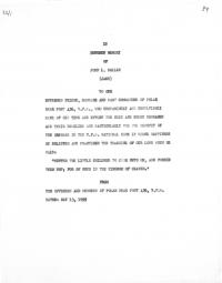
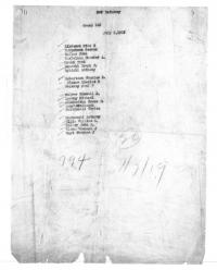
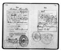
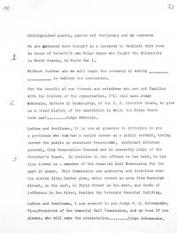
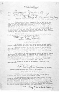
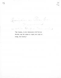
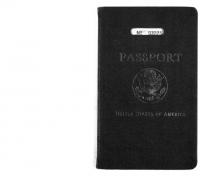
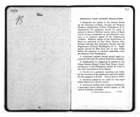
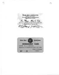
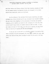
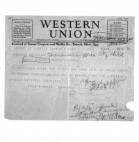
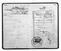
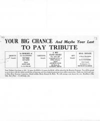
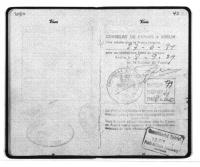
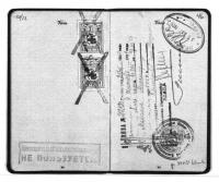
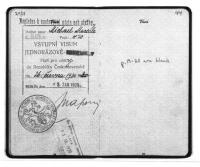
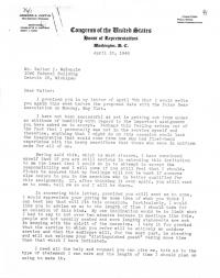
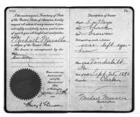
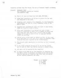
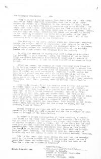
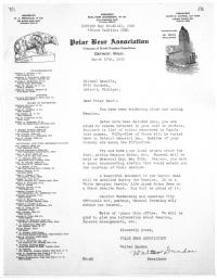
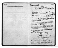
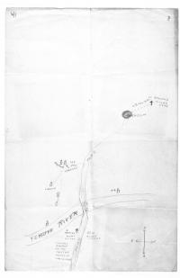
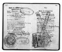
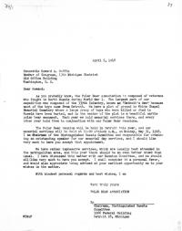
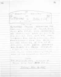
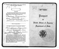
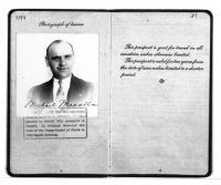
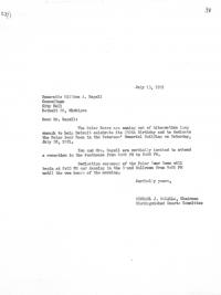
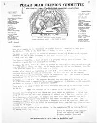
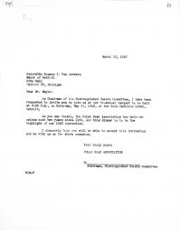
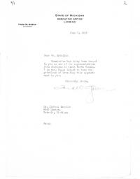