Control of the Pacific (Michael Eghbal)
Most people grow up learning that an Italian explorer named Christopher Columbus discovered the “New World” in the year 1492 in what was originally a search for alternate routes to India, and that was that. However, you come to realize that the exploration of the Americas and the progression to what it is today was much more complicated than that. There were hundreds of explorers all traveling to and from various lands and islands throughout the Pacific land and sea, looking for new trade routes, resources, or even to study astronomy. In David Igler’s The Great Ocean: Pacific Worlds from Captain Cook to the Gold Rush, he discusses the meaning behind the Pacific islands and waters through the lens of both natives and non-natives, and how both groups interact with the regions and each other. Then in Joshua Reid’s The Sea is My Country: The Maritime World of the Makahs, he examines the Makahs, a tribe located in the Pacific Northwest of America, and their power dynamic with the non-natives within their land, specifically in relation to trading. And lastly, when looking at both scholars’ arguments with John Cary’s 18th century map titled “The Western Hemisphere”, which displays the exploration and trade routes of European explorers throughout the Pacific, we see that the non-natives had clear power over the natives for control of the land and narrative, as they were able to do as they pleased.
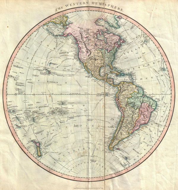
John Cary was a London based cartographer who lived from the years 1754 to 1835, and was one of the most prominent cartographers in the 18th and 19th centuries. One of his most well known pieces of work is titled “The Western Hemisphere”, and was created in 1799. It displays both Americas, the Pacific Ocean and its islands, as well as many of the exploration routes that were used at the time. A budding United States of America only reaches out west until the Mississippi River, where the rest of the land still belongs to the indigenous. South America is broken up into regions to represent the Amazon rainforest. And both continents are divided into regions to illustrate which lands belong to the Americans, Spanish, and indigenous peoples. There are a few interesting features to note, such as how there is a large body of water in western America just labeled “Lake”, which we now know is the Great Salt Lake, located in Utah. Also, Greenland is shown as connected to North America, even though we later discovered that it is just an island. And there are many native tribes designated throughout Canada and western America. Lastly, one of the most significant and useful features on this map is the trade and exploration routes. These trails belong to various explorers, including James Cook, Charles Cook, Jean-Francois de la Perouse, and multitude of other European explorers and voyagers.
Igler’s The Great Ocean: Pacific Worlds from Captain Cook to the Gold Rush goes into depth on the relationship between the natives of the Pacific islands and the non-native explorers that come through looking to advance their trade interests. In fact, by the late 18th century the Pacific seemed to turn into an absolute hub for trade. This is due to the major influx of European ships coming through this area, as they were set on finding and developing trade systems to improve their economies. The voyagers pushed for so much trade in these areas that their coasts transformed into commercial areas for business. This included the Californian and Northwest coasts, Hawaii, South America, Alaska, and even to China. The explorers were blatantly using the Pacific Ocean and its nations simply to increase their profits and bolster their enterprise. In fact, these lands were used by the non-natives so much that, "The Hawaiian Islands gradually became the center point destination not only for trade, but also for sailors’ libidinous activities, naturalists’ investigations, and, by the 1820s, Protestant missionary activities” (Igler 9). The islands of Hawaii simply became a staple of the explorer's life, as it was such an important area in the Pacific. Even though many of these trading hubs and routes were mutually beneficial to both the natives and non-natives, there was no regard for the culture and society of these areas throughout the whole process. After all, the book follows the journeys of British explorer James Cook, whose name is even in the title. And with the non-native explorers having so much power in this area, they were able to twist and form the narratives to their liking. For example, we see that both the natives and non-natives used many forms of violence on each other. Igler explains that when the natives met non-natives for the first time, "people on the shore welcomed or warned off ships, people exchanged goods or blows ... but certain actions transpired with such regularity that they appear almost commonplace. Among these conventions were the exchanging of hostages and the taking of captives" (Igler 76). Both groups were seen to partake in these vile acts. But in the end, it is the indigenous people who are labeled as uncivilized savages. Because the outsiders think so lowly of the natives, we see that they refuse to see any similarities between themselves, and push the narrative that they are above them in every way. When in reality, both groups identified many possible benefits from their interactions and trade, and simply wanted what was best for their people. It is important to remember that there are always two sides to every story, but you will usually only hear it from the side with more influence and power.
Much of what Igler revealed in his book can also be seen in Cary’s map of the Pacific and its trade routes. First we have to identify that the map was created from the point of view of the British, or in other words, the non-natives. So this means that the land, boundaries, and names are all made with the context of the non-natives. The waters and shores of these lands are filled with trails and names belonging to voyagers, which goes to show just how much power the outsiders had on this land. But the map does not really show just how, exactly, the non-natives took control of these regions. As we saw explained by Igler, the voyages outsmarted and even performed heinous acts to overtake the natives, whereas the map only displays the borders and trade routes. Also, we have been reading about Captain James Cook, but there are a myriad of other explorers that have claimed their ownership in the history of the pacific, in places that Cook and his crew never even reached. Just as Igler explained, there was such a focus on the economy and profits of their home countries that they walked all over the indigenous people and their homes. The explorers easily used them to get what they wanted, without any concern for the natives or their culture, and as we see in the primary source, this was an extremely common occurrence. And just like it was discussed in The Great Ocean: Pacific Worlds from Captain Cook to the Gold Rush, history is written by the victors, and the victors in this story are definitely the non-natives. These countries were able to send voyager after voyager into the homes of indigenous people and create a whole enterprise using their land and resources.
The next book, Reid’s The Sea is My Country: The Maritime World of the Makahs, discusses the power dynamic between the Makahs of the Pacific Northwest and the non-natives who create trading posts on their land. At these posts, the natives would trade with the outsiders, as they believed there was a lot to get out of it. While the non-natives were able to bring resources and goods back to Europe, the indigenous tribes were introduced to new aspects of life. They discovered new technologies, such as the musket, which allowed them to have the upper hand on nearby tribes. And even though the natives were interacting with the outsiders, they were able to keep their identities, as they remained mostly independent. Aside from these trading posts, the “US and British settlers began establishing sawmills, fishing operations, farms, and small settlements in the region” (Reid 91). The non-natives really worked hard to get as much as they could out of these areas, whether it be for economic profit or simply power of the land. Speaking of power, Reid also discusses the notion of power, and what it meant to possess it in these areas. One aspect of power was the sheer manpower that one group possessed. The bigger the population, theoretically, the more power one group had on the other. But of course there were many other aspects, such wealth. The idea of wealth is connected to who controlled the work and trade in the area, and therefore simply had more wealth. And finally, there was the knowledge of the land that contributed to one group’s power. Things like mastering the environment, knowing the seasonal changes, and understanding natural occurrences and how to maximize resources added to overall power. But different groups had different goals in mind. The non-natives wanted a strong economy and bigger profits, which is why they focused on the trading systems. And the natives wanted more control over other tribes and groups, while keeping their true identities, which led them to concentrating on their society and the environment around them. Reid makes it clear that the non-native explorers saw the ocean and environment of the indigenous as just a way to get from point A to point B. It was an opportunity for the outsiders to expand their commence and business; they used it for their personal concern. But for the natives, the environment was their way of life, to put it simply. They depended on their knowledge of the land and ocean for their survival, as they had to acquire resources for their society. Furthermore, much of the natives’ culture was based on their surroundings and environment; it was their home. But after some time, we see that the power of the Makahs and other tribes in that region begin to dwindle. As the non-natives began to use the tribes solely as a means of profit, they slowly began to disrespect the natives and their culture. The natives began to create new boundaries in the region based on what would be most economically sufficient, as opposed to the previous boundaries already created by the native tribes. Additionally, the outsiders brought various diseases to the native population, which took a huge toll on their people, killing thousands. Furthermore, "the high mortality and loss of experienced chiefs threatened to undermine the ability of the People of the Cape to control the čadi borderland” (Reid 117). It really looked like everything was falling apart for the native populations. They went from trading with the outsiders just for their own convenience, to trading with them to keep the little control they held, and just to even exist. This shifted the power even more into the hands of the non-natives, as now they had full influence on the Pacific Northwest.
There are many correlations between the ideas revealed in Reid’s writing and what is represented on Cary’s map of the Western Hemisphere. While the natives knew much more about the environment and nature of the Pacific Northwest, the Americans and Europeans really did not need to have that knowledge. In reality, all the non-natives needed was access to the resources within the regions, and to create trade routes throughout the Pacific. Whether these routes were in the ocean, or just on land, the non-natives were able to accomplish their goals. As long as non-natives were getting what they wanted out of the indigenous tribes, they were content. And because the trading started off mutually beneficial, both groups continuously worked together. There is also the aspect of the non-natives walking all over the indigneous people, which is definitely present in Reid’s book. They completely disregarded the borders and customs of the natives, and even killed off much of their population by bringing diseases into their societies. This is a factor in what allowed them to work so rampant in the Pacific, as is shown in Cary’s map. It was their belief of superiority and sheer dominance over the natives that allowed them take control of the entire Pacific, in both the seas and land. But what isn't presented in Cary's map is the extent in which the explorers and non-natives worked to use these lands to their advantage. Reid goes into detail on how the non-natives created trading posts, farms, and other settlements in these areas. Furthermore, they used the natives for their knowledge on the land, something the explorers simply did not have. The non-natives made sure to cover all bases when it came to power over the native tribes, since they knew what they wanted from the start.
As more and more explorers came into the Pacific looking to create trade routes and bolster their economy, they completely monopolized the Western Hemisphere and overpowered the native peoples. In his work The Great Ocean: Pacific Worlds from Captain Cook to the Gold Rush, Igler explains how explorers like James Cook were able to come into the islands of the Pacific and use the native’s land for their own profit, while creating a positive narrative for themselves. And in Reid’s The Sea is My Country: The Maritime World of the Makahs, he goes into detail on the developing relationship between the indigenous tribes and the outsider American and British. Both readings help explain the truths behind Cary’s map of the Pacific titled “The Western Hemisphere”. Whether the non-natives were working with trade routes in the Pacific Ocean, or were creating trading posts along America’s Pacific coast, they were always successful in taking control from the natives and using their land and resources in their favor.
Work Cited
Igler, David. The Great Ocean: Pacific Worlds from Captain Cook to the Gold Rush. Oxford University Press Inc, 2013.
Reid, Joshua L. The Sea Is My Country: The Maritime World of the Makahs. Yale University Press, 2015.
Cary, John. The Western Hemisphere, New Universal Atlas, 1799. University of Washington Libraries.
Link to Primary Source: https://digitalcollections.lib.washington.edu/digital/collection/maps/id/36
This page has paths:
- Pacific Postcards (S21 midterm essays) Sean Fraga