U.S. Military Involvement in the South Pacifc
Westerners have a significant history of expansion and occupation, especially in the South Pacific. From early explorers who exploited Hawaiian resources and labor, to Europeans who commodified the sea cucumber in the Fiji islands, the countless encounters between Western and European people have always led to social and environmental consequences for the indigenous peoples. World War II (WII), long after the Westerners first appeared in these islands, marked the beginning of downward mobility and autonomy for the Indigenous peoples of the South Pacific. Events like the Battle of Makin Atoll, as depicted in the photo, is an example of how the U.S. military utilized the interconnected geography of the pacific islands to bolster their agenda in WWII. With their new foreign territories, they were able to test nuclear weapons away from the mainland. These tests ultimately lead to the displacement of indigenous peoples along with significant political turmoil revolving around U.S. occupation of Pacific islands, turmoil that has persisted through today.
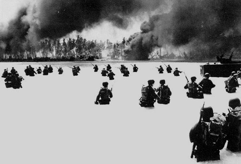
The picture above, taken by an unknown photographer, shows the 165th Infantry advancing on Butaritari Beach of Makin Atoll island. This was taken on November 20th, 1943, the beginning of a four day battle with the Japanese who had occupied the island more than two years prior. Just after the attack on Pearl Harbor, December 10th, 1941, the Japanese occupied most of the Gilbert Islands, Makin Atoll included. These islands offered strategic positioning both offensively and defensively against the U.S. and allied forces. Over the course of a year the Japanese constructed a seaplane base and defenses on the Island. But, on August 17th, 1942, U.S. marines attacked. This assertion led to some destruction of Japanese planes and fuel depots, and resulted in the loss of 21 U.S. troops. More significantly though, it made the Japanese realize the vitality of keeping Makin Atoll and the other Gilbert Islands. After the attack, they re-occupied Makin Atoll with more men and completed the seaplane base to accommodate their most deadly planes.
At the time of the 1942 attack, both sides knew that the defense perimeter of the Gilbert Islands was key to advancing the strategy of both. But, the U.S. did not have any bases from which to operate in this northern chain of islands nor did they have the resources to attack the “heart of the Japanese outer defense perimeter.” (Allmon) To overcome this they utilized the interconnected geography of the south Pacific to carry out an offensive maneuver:
“Admirals King and Nimitz decided to take the Marshalls in a step-by step operation via the Ellice and Gilbert islands. The Gilberts lay within 200 miles of the southern Marshalls and were well within range of U.S. Army Air Forces (USAAF) aircraft based in the Ellice Islands, which could provide bombing support and long range reconnaissance for operations in the Gilberts. With those advantages in mind, on July 20, 1943, the Joint Chiefs of Staff decided to capture the Tarawa and Abemama atolls in the Gilberts, plus nearby Nauru Island. ” (Allmon)
Not only did the geography of the South Pacific allow for the propulsion of the U.S. military towards their combat objectives, it also allowed them to better train their troops. As seen in the photo, combat in this part of the world required soldiers to be competent in both marine and terrestrial environments. To prepare for their attack on Makin Atoll, the U.S. 165th Infantry was trained in “Tropical hygiene and other skills for living in the jungle... The troops practiced attacks in jungle terrain, night operations, attacking fortified jungle positions, and the elimination of Japanese snipers.” (Allmon) This kind of specific training was possible because the U.S. had access to other U.S. Pacific island territories, allowing them to train in the exact conditions in which they would be fighting.
In addition to their on land training, “the 165th conducted joint amphibious training on beaches in the Hawaiian Islands. The first rehearsal was held in Maalaea Bay, Maui, on November 1, 1943, with simulated naval gunfire and air support.” (Allmon) This preparation paid off. After utilizing the immense interconnections of U.S. occupied Pacific Islands the military arrived at Makin Atoll. On November 20th, 1943 the 165th Infantry set foot on the beach and three days later, the U.S. was victorious in taking the island with far less casualties than the Japanese.
The taking of Makin Atoll was significant for the U.S. military and their agenda in the Pacific. It is the northernmost island in the Gilbert Island chain, which is extremely close to the Marshall Islands, the “heart of the Japanese defense perimeter.” (Allmon) This new strategic vantage point led to the eventual U.S. dominance of the Marshall islands and other key regions of the South Pacific.
The U.S. arrival on these new islands was met with joy and gratitude by the local indigenous populations. In Dudziak’s How The Pacific World Became West, Ruban Juda, a Bikini native recounts the kindness of the U.S. troops upon their arrival to Bikini Atoll, describing it as “‘a very fortunate event for our people.’” (171) This same sentiment was found during the Battle of Makin, in which the natives helped in the U.S. fight against the Japanese. These feelings did not last long once the U.S. began to exploit these places to test nuclear weapons to further their military objectives. As a result, significant social consequences were felt throughout the South Pacific. On February 10th, 1946, the “small” local population of Bikini Atoll was required to move in order for nuclear testing to begin. Bikini Atoll had been chosen because there was a large lagoon in which military ships could be anchored and because it was considered a “‘hole in the wall’'' as cultural geographer Denis Cosgrove described it. The U.S. disregarded the importance of the local population because their small island, which had already been flattened by violence, no longer was deemed “‘useful’” by the U.S. except for military endeavours. (172) As Duziak puts it, “The US government sought a space where the world’s most devastating weapon could be tested without disturbing anyone that mattered.” (173)
Ultimately, the locals moved without any resistance. According to the Americans they were happy to leave their home but in reality, they “‘didn’t feel [they] had any other choice but to obey the Americans.’” (Lore Kessibuki, A Native to Bikini, 172) On June 30th, 1946, the U.S. released their first test atomic bomb named Gilda into Bikini’s lagoon. This marked the end of Bikini being a home for anyone. Throughout the multitude of tests that followed, the displaced locals continued to hope that they would soon return home. But, the radiation and contamination made this impossible. The natives were deemed “Nuclear Nomads” who became victims of their forced displacement to accommodate the nuclear tests and to the other populations that were similarly displaced. (175) Bikini island has never been resettled and its original population and their offspring remain dispersed across the South Pacific. Their story reflects the experience of many natives who populated outlying U.S. territories that were taken in the war. Though they are now technically Americans, they exist in the margins of what we know as the U.S. which means their voices are not heard and their land is used to empower the interests of the “logo map” United States. These people and their lands are pawns to the ambiguous legal definitions our government uses to keep them at a distance.
During WWII the U.S. military’s successful expansion and ultimate victory in the South Pacific was made possible by their efficient use of the interconnected geography of the South Pacific islands. Upon taking islands like Makin Atoll, as shown in the accompanying photograph, the U.S. was able to successfully push out Japanese defenses and occupy the Pacific. Initially, the indigenous peoples welcomed the U.S., hopeful for their future and happy to be rid of the Japanese. But, as the war progressed and the Nuclear Age ensued, their hope was destroyed as their homes and islands were taken for Nuclear testing. The resulting displacement and social consequences are ever lasting to this day.
Works Cited
Allmon, William B. "Gilbert Islands Campaign: Takin' Makin." World War II 11 1998: 58. ProQuest. Web. 4 Nov. 2021.
Dudziak, Mary L. “How the Pacific World Became West.” World War II and the West It Wrought/, Stanford University Press, 2020, pp. 161–178.
Rhp. “The Pacific Theater in Pictures, 1942-1945.” Rare Historical Photos, 14 Oct. 2017, https://rarehistoricalphotos.com/pacific-theater-in-pictures-1942-1945/.