Reclaiming Ohi:yo'- Restoring the Altered Landscape of the Beautiful River Main MenuWelcomingFront page for this Digital Exhibit.The Seneca Nation of IndiansWe call ourselves Onödowá'ga:' (oh-non-doh-wah!-gawh!), which means "People of the Great Hill". We are one of six other nations that collectively call ourselves Hodinöhsö:ní (hoh-dee-nonh-sonh-neeh!), meaning "People of the Longhouse".The Kinzua Dam ProjectOur elders fought for our land and sovereignty in the 1950s and 1960s. They fought to stop the construction of Kinzua Dam.The Allegheny ReservoirThe reservoir has altered the landscape, ecosystem, and our interactions with Ohi:yo.The Allegheny Reservoir: A Visual Depiction of Water LevelsAt times of water storage the water depth of the river channel is approximately 26 feet, with as little as 6 to 8 feet of water during the winter months.The Significance of Kinzua to our Seneca PeopleThe U.S. Army Corps of EngineersThe U.S. Army Corps of Engineers in collaboration with the U.S. federal government built Kinzua Dam between 1960 and 1965.Kinzua Era TimelinesThis page provides two different temporal representations of the Kinzua Era (1956-1966).Kinzua Dam's Environmental ImpactsThe creation of Kinzua Dam has had lasting environmental impacts on our land and water. Learn more here.Ohi:yo' Restoration and Resiliency ProjectsMembers of the Seneca Nation's Watershed Resources Working Group are involved in various restoration and resiliency projects for our Ohi:yo'. The Seneca Nation's Fish and Wildlife Department in particular engages in projects related to building artificial habitat, repopulating our river's Walleye population, and building trenches to help land locked fish.Seneca Nation Fish and Wildlife DepartmentThe Nation's Fish and Wildlife Department engages in restoration and resiliency projects related to Ohi:yo'.Fighting for the Water: Fracking Wastewater in Ohi:yo'In 2016 the Pennsylvania Department of Environmental Protection (PA DEP) began deliberating a 1,000-barrel/day of unconventional gas drilling wastewater (Frack Wastewater) disposal facility in Potter County proposed by Epiphany Allegheny LLC. In response to the news of these fracking plans, our Seneca people again fought for our people, our communities, and our Ohi:yo'.A Legacy of ResilienceWe will continue on.Access and Use RightsFor our full statement on rights and use of our exhibit contents see this page.Additional ResourcesThis page contains additional resources that can provide more in-depth information that is perhaps not included within our exhibit.About this ExhibitThis page contains information about our intra-Nation departmental collaborations and exhibit acknowledgements.The Seneca-Iroquois National Museum663b8929f7a99e6bad2d94d8e2c4f4c0dbfcfc0fDana Reijerkerk3c44fb85ab096c2290175e81dd4f16f0002a41e0This exhibit was published by the Seneca-Iroquois National Museum, 2018.
Ohi:yo'
1media/80.1002.0022.jpg2018-07-25T21:44:55-07:00Dana Reijerkerk3c44fb85ab096c2290175e81dd4f16f0002a41e03086110Ohi:yo', our Beautiful River, has always been our home and source of nourishment.image_header2018-08-15T22:55:46-07:00Dana Reijerkerk3c44fb85ab096c2290175e81dd4f16f0002a41e0For millennia, Ohi:yo' flowed freely, providing life to a thriving ecosystem and to our Seneca people.The Seneca people have had a long relationship with Ohi:yo'.
The river was an ideal habitat for a variety of marine life that we consider culturally important. Plants we know are good for medicine grew along its borders.
We built our communities and way of life around Ohi:yo'.
This page has paths:
12018-07-15T22:51:40-07:00Dana Reijerkerk3c44fb85ab096c2290175e81dd4f16f0002a41e0IntroductionDana Reijerkerk60Front page for this Digital Exhibit.visual_path7871122018-08-11T20:31:19-07:00Dana Reijerkerk3c44fb85ab096c2290175e81dd4f16f0002a41e0
1media/85.1003.0209.jpg2018-07-12T14:24:00-07:00Dana Reijerkerk3c44fb85ab096c2290175e81dd4f16f0002a41e0The Kinzua Dam Project34plain7878892018-08-09T21:12:10-07:00Angela Schöpkea9b85985047875065a895f217f6d9371b9e08ba7
1media/A.600.039.0002bv2.jpg2018-07-12T14:24:35-07:00Dana Reijerkerk3c44fb85ab096c2290175e81dd4f16f0002a41e0Kinzua Dam's Environmental Impacts17The creation of Kinzua Dam has had lasting environmental effects on our land and water. Learn more here.vispath7829232018-08-14T17:41:05-07:00Dana Reijerkerk3c44fb85ab096c2290175e81dd4f16f0002a41e0
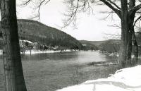
12018-07-12T18:22:32-07:00Dana Reijerkerk3c44fb85ab096c2290175e81dd4f16f0002a41e0River in Winter10A photograph of the Allegheny River during the winter months, taken on the Allegany Territory of the Seneca Nation of Indians.media/85.1003.0070.jpgmeta2018-08-03T16:45:45-07:00Seneca-Iroquois National Museum2018-07-16stillImage85.1003.0070topography (attribute), riverbanks, mountain ranges, hills, riversSeneca-Iroquois National MuseumengA photograph of the Allegheny River during the winter months, taken on the Allegany Territory of the Seneca Nation of Indians.image/jpegreformatted digitalphotoprint, electronicdateCreated encoding= "w3cdtf"; dcTerm:temporallanguageOfCataloging authority = "iso639-2b"; dcTerm:languagerecordCreation Date encoding = "w3cdtf"; dcTerm:datesubject authority = "aat";dcTerm:subjectsubject authority = "tgn"; dcTerm:coverageRecord has been transformed into MODS from the original accession record. Metadata originally created in a locally modified version of qualified Dublin Core.Allegany Reservation, Allegany (county), Allegany RiverTed HetzelThis record was created by Dana Reijerkerk.1 photograph; Black and White, Glossy 4" x 6" 1961-08Dana Reijerkerk3c44fb85ab096c2290175e81dd4f16f0002a41e0
12018-07-12T16:11:55-07:00Dana Reijerkerk3c44fb85ab096c2290175e81dd4f16f0002a41e0Fighting for the Water5plain2018-08-11T22:22:15-07:00Dana Reijerkerk3c44fb85ab096c2290175e81dd4f16f0002a41e0
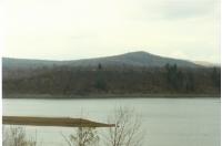
12018-07-25T15:28:34-07:00Dana Reijerkerk3c44fb85ab096c2290175e81dd4f16f0002a41e0Erosion at Highbanks Near Highbanks Campground3Come Fall of every year, much of the bottom of the Reservoir has begun to dry up as the water reserves are lowered at the discretion of the U.S. Army Corps of Engineers. This seasonal lowering and emptying of the water reserves held within the reservoir leaves the land exposed and unprotected to weather elements, which in combination with the water fluctuations throughout the year, expediates the erosion of the shorelines and banks of Ohi:yo'. In addition, many of the shorelines along Ohi:yo' lack the needed plant growth, such as trees, to protect them from erosion. Pictured here is a wide shot that includes the Highbanks Campgrounds of the erosion along the shoreline of Ohi:yo'.media/A.600.039.0002a.jpgmeta2018-08-03T16:42:10-07:00Seneca Nation Archives Department2018-07-16stillimageA.600.039.0002atopography (attribute), riverbanks, mountain ranges, hills, ridges (landforms), banks (landforms), rivers, erosionSeneca-Iroquois National MuseumengThe construction of Kinzua Dam and the Allegany Reservoir was completed in December of 1965. Seneca Nation of Indian land within the Allegany Territory that was inundated with the construction of the Allegany Reservoir is only underwater for part of the year. Come Fall of every year, much of the bottom of the Reservoir has begun to dry up as the water reserves are lowered at the discretion of the U.S. Army Corps of Engineers. This seasonal lowering and emptying of the water reserves held within the reservoir leaves the land exposed and unprotected to weather elements, which in combination with the water fluctuations throughout the year, expediates the erosion of the shorelines and banks of Ohi:yo'. In addition, many of the shorelines along Ohi:yo' lack the needed plant growth, such as trees, to protect them from erosion. Pictured here is a wide shot that includes the Highbanks Campgrounds of the erosion along the shoreline of Ohi:yo'.photoprint, electronicimage/jpegreformatted digitalMaps & Boundaries Photo's Highbanks Bank Erosion 1987-1992Record has been transformed into MODS from the original accession record. Metadata originally created in a locally modified version of qualified Dublin Core.languageOfCataloging authority = "iso639-2b"; dcTerm:languagerecordCreation Date encoding = "w3cdtf"; dcTerm:datesubject authority = "aat"; dcTerm:subjectsubject authority = "tgn"; dcTerm:coveragedateCreated encoding= "w3cdtf"; dcTerm:temporalAllegany Reservation, Allegany (county), Kinzua Reservoir (reservoir), Allegany RiverSeneca Nation Maps and Boundaries DepartmentThis record was created by Dana Reijerkerk.1 photograph; Color, 4" x 6" 1989-11-06Dana Reijerkerk3c44fb85ab096c2290175e81dd4f16f0002a41e0
1media/FWD-009.jpg2018-07-25T21:54:02-07:00Dana Reijerkerk3c44fb85ab096c2290175e81dd4f16f0002a41e0The Walleye Fish Hatchery1The Seneca Nation built the Walleye Fish Hatchery in 2012 to raise Walleye and release them back into Ohi:yo' (Allegany River). Walleye were once one of the most populous fish species in the ecosystem and are considered culturally important to the Seneca. Learn more about...plain2018-07-25T21:54:02-07:00Dana Reijerkerk3c44fb85ab096c2290175e81dd4f16f0002a41e0
1media/SINM-003-v3.jpg2018-08-09T18:47:11-07:00Dana Reijerkerk3c44fb85ab096c2290175e81dd4f16f0002a41e0The Watershed Resources Working Group (WRWG)1The WRWG is a technical advisory board to our Nation's Council, whose sole purpose is to protect the environment.plain2018-08-09T18:47:12-07:00Dana Reijerkerk3c44fb85ab096c2290175e81dd4f16f0002a41e0
This page references:
12018-08-15T14:46:35-07:00Ohi:yo'2Photograph of Ohi:yo' with a view of a Quaker school and farm.media/83.1019.0005.jpgplain2018-08-15T14:50:49-07:00Seneca-Iroquois National Museum2018-08-13stillimage83.1019.0005native peoples reservations, rivers, topography (attribute), riverbanks, banks (landform)Seneca-Iroquois National MuseumengPhotograph of Ohi:yo' with a view of a Quaker school and farm.print, electronicimage/jpegreformatted digitalRecord has been transformed into MODS from the original accession record. Metadata originally created in a locally modified version of qualified Dublin Core.languageOfCataloging authority = "iso639-2b"; dcTerm:languagerecordCreation Date encoding = "w3cdtf"; dcTerm:datesubject authority = "aat"; dcTerm:subjectsubject authority = "tgn"; dcTerm:coveragedateCreated encoding= "w3cdtf"; dcTerm:temporalAllegany River, New York (state), Cattaraugus (county), Allegany ReservationGeorge Abrams (donor)This record was created by Dana Reijerkerk.1 photograph, 11" x 14", black and white, glossy; originally contact sheet with three photos1920-1939
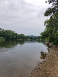
12018-08-15T14:28:42-07:00Ohi:yo' Today2Photograph of Ohi:yo' today.media/SINM-003-v3.jpgplain2018-08-15T18:13:01-07:00Seneca-Iroquois National Museum2018-08-13stillimageSINM-003rivers, topography (attribute), independent soverign nations, native peoples reservationsSeneca-Iroquois National MuseumengPhotograph of Ohi:yo' today.born digitalimage/jpegelectronicRecord has been transformed into MODS from the original accession record. Metadata originally created in a locally modified version of qualified Dublin Core.dateCreated encoding= "w3cdtf"; dcTerm:temporalsubject authority = "tgn"; dcTerm:coveragesubject authority = "aat"; dcTerm:subjectrecordCreation Date encoding = "w3cdtf"; dcTerm:datelanguageOfCataloging authority = "iso639-2b"; dcTerm:languageNew York (state), Cattaraugus (county), Allegany Reservation, Allegany (county)This record was created by Dana Reijerkerk.Dana Reijerkerk1 photograph2018-08-13