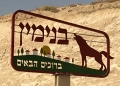
B is for Benjamin
The Benjamin sign is only in Hebrew, a message for the colonists alone. But its visual message is clear enough. The howling wolf arcs his body over a cluster of white houses with red roofs, set against green grass and trees. The imperial echo of the Roman wolf cannot be missed. The empire protects. The houses are recognisably those of the illegal settlements that cover every hilltop in the ‘West Bank,’ which all have red roofs, in part to make them visible to the Israeli airforce as settlements.
The grass and trees transform the scene into an evocation of American suburbia, the picketfence view of the world. When I took this picture, the temperature was 115 F (45C). Any greenery in a Dead Sea settlement—and there is plenty—is both an ideological production and an environmental fabrication that relies on appropriated water. 10,000 settlers living in the Jordan Valley and Dead Sea area use one-third of the water accessible to the entire Palestinian population in the ‘West Bank’ (estimated at over 2.5 million).