E is for Environment
So the activists I spoke with had no means, or incentive, to think in terms of environment. In the desert, green concerns become green colonialism. Occupation articulates all issues and leaves no remainder.
One of the projects I had proposed was to follow the Jordan River to measure the decline in the water level and other environmental concerns. It turned out that there is no river any more. The water is diverted by both Jordan and especially Israel further north. Despite well-publicized claims in 2013 that additional water had been pumped into the river, there was no trace of it.
The well-made N90 road that tracks the river, and goes down to the tourist resort of Eilat, does not run adjacent to its (former) course. Every side road we took trying to find it led to a settlement, an army base or a nature reserve like this one.
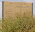
The sign claims the space as 'Judea and Samaria,' the revived Biblical name for the 'West Bank.' It then institutes a 'wetland' in the desert, where it was 120F the day we visited. Key to the importance of this designation is the stipulation that no one is allowed to remain the park after dusk. Any Palestinian who might own land here or any Bedouin who wanted to graze their animals would be subject to arrest. The wetland in effect annexes the land to the regime.
The consequences are visible once you reach the Dead Sea. Without exaggeration, it is clear that the Dead Sea is dying. Its level has fallen to such an extent that it has divided into two. The present day water level is some forty metres below what is was in the 1930s. That rate is accelerating according to a recent article in Ha'aretz:
This fall is entirely visible when you are at the Dead Sea. In the photograph above, taken from the shoreline, the perspective is foreshortened: the red pier that marked the former level of the Sea is way above the present 'beach' that has obviously been constructed using trucked in gravel and sand. In some locations, roads have been built so people can get to the remaining water using golf carts because it's too hot to walk the distance of half a mile or more.The level of the Dead Sea... dropped 13 centimeters in August [2016]. Since the beginning of the hydrological year (which begins in October), the Dead Sea level has dropped 103 centimeters, 22 percent more than the drop in the corresponding period of the previous hydrological year. Over the past 25 years, the level of the Dead Sea has dropped nearly 25 meters. Today almost no water flows into it from the Jordan River
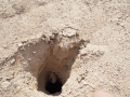
Elsewhere in the area, the sinking water level is leading to the sudden appearance of sink holes, which are thought to be caused by fresh water dissolving the salt and causing the ground to collapse, although no one is really sure. Locals denied to us that there were any such sink holes, even though it was obvious bull dozers had recently been at work. Nearby we found new sinkholes beginning--they start small.
You can still float in the salty water, which is claimed to cure skin ailments. But as you look up at the distant former shore line, or across at a beach fenced off with warnings about mines, it's hard to feel a connection to 'nature.' If, as Amerindians argue, there is one culture but many natures, the Dead Sea is exemplary for what the colonial enclosure of nature looks like--dangerous, deceptive, and in denial.
This page has paths:
- The Alphabet Nicholas Mirzoeff