How To See Palestine: An ABC of Occupation

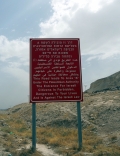
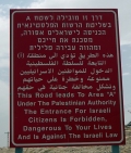
A is for Area A: there is no 'West Bank'

The regime covers the territory with signs, expressing its intent. These signs are posted wherever Area A, under the nominal control of the Palestinian Authority (PA), borders with what the regime considers to be the state of Israel. Apparently, the Hebrew and Arabic versions are at variance. The English message is clear: Palestinians are dangerous. Red alert. Less obvious is that Area A covers only 18% of  what is still referred to as the ‘West Bank’ in a series of increasingly isolated pockets, centered on the Palestinian cities like Ramallah and Nablus. No functional state can be made from these islands. The ‘two-state solution’ is visibly impossible.

Although Area A signs are quite common, there are no others. Where do you enter Area B (largely considered defunct on the ground) and Area C, now considered to be some 63% of the ‘West Bank’? There are no signs other than the change of rules of engagement and the appearance of settlements, settler buses and the settlers themselves. Palestinians know, as do the settlers and the Israeli Defense Force. So the Area A signs are really for people like me, or Israeli leftists, venturing into the ‘West Bank.’ I don’t think they work. I hadn’t been there long before the sight of an Area A sign made me relax and feel safe.


This page has paths:

This page has tags:

This page references: