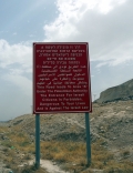
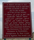
A is for Area A
Less obvious to the viewer is that Area A covers only 18% of what is still referred to as the ‘West Bank’ in a series of increasingly isolated pockets, centered on the Palestinian cities like Ramallah and Nablus. No functional state can be made from these islands. The ‘two-state solution’ is visibly impossible because the PA has no domain over most of the 'West Bank.' Clearly, there is no geo-political entity we can call the 'West Bank.'
Although Area A signs are quite common, there are no others. Where do you enter Area B (largely considered defunct on the ground) or Area C, where Israeli military rule is in force, now considered to be some 63% of the ‘West Bank’? There are no signs other than the change of rules of engagement and the appearance of settlements, settler buses and the settlers themselves. Palestinians know, as do the settlers and the Israeli Defense Force. So the Area A signs are really for people like me, or Israeli leftists, venturing into the ‘West Bank.’ Nonetheless, I hadn’t been there long before the sight of an Area A sign made me relax.
This page has paths:
- The Alphabet Nicholas Mirzoeff