Thanks for your patience during our recent outage at scalar.usc.edu. While Scalar content is loading normally now, saving is still slow, and Scalar's 'additional metadata' features have been disabled, which may interfere with features like timelines and maps that depend on metadata. This also means that saving a page or media item will remove its additional metadata. If this occurs, you can use the 'All versions' link at the bottom of the page to restore the earlier version. We are continuing to troubleshoot, and will provide further updates as needed. Note that this only affects Scalar projects at scalar.usc.edu, and not those hosted elsewhere.
The Promise and Practice of Teaching Data Literacy in Social Studies: A Companion Site
Main Menu
A Taxonomy of Data Visualizations
Information can be visualized in multiple ways, from bar graphs to scatterplots, choropleth maps to distribution maps, timelines to time series. Designers can choose from an array of graphical elements such as points, lines, or icons used to represent data, and multiple aesthetic attributes such as color, shape, and size. Furthermore, designers can apply multiple combinations of titles, legends, and explanatory text to provide context for a data visualization. Given the almost dizzying array of data visualizations students may encounter in social studies, it is helpful to place them in categories related to the types of questions they will help us answer.
Data Visualizations as Primary Sources
Humans have been creating different types of data visualizations for centuries. Explore this collection of timelines, maps, graphs and charts to see what they reveal about the historical time and place in which they were produced.
How do students learn with data visualizations?
Reading data visualizations in print and online social studies texts can improve students' overall comprehension and quality of reasoning. And there is evidence to suggest that reading data visualizations helps students better understand historical and geographic context, multiple causation, and change over time — all important concepts for students to grasp in social studies subject areas. However, students may face significant challenges in trying to make sense of different kinds of data visualizations. This section provides insight into both benefits and challenges of reading timelines, maps, and graphs and charts.
How should students analyze data visualizations in social studies?
The challenges that data visualizations present, coupled with their prevalence in social studies texts, standardized assessments, in online social studies resources, and as sources of information in society, suggest that teaching with and about data visualizations in social studies is essential. This module provides guidance for how teachers can support students' data literacy for social studies.
How do I help students create and integrate data visualizations for social studies?
This page highlights several tools that are useful for data-based projects in social studies. And accompanying each tool is a "minimal manual" that provides guidance for using the tool in social studies inquiry- and project-based learning.
Project-Based Learning Activities for Data Literacy in Social Studies
Lorem ipsum dolor sit amet, nec constituto comprehensam te. Sea no affert nemore comprehensam, eum te purto soleat accusata. Ea est magna malis. No atqui iudico est. In vel propriae suavitate. Est homero timeam cu, novum persecuti mea an.
Index of Lesson Plans
This page contains a list of the minimal manuals and lessons found on this website. Minimal manuals are designed to be adapted to different grade levels and do not have a grade designation associated with them. Lesson plans are organized according to the school level for which they are designed. However, many of these lessons can be adapted for different grade levels.
Tamara Shreiner
72eaa2d1ba1352b75b8a8da73e879a4ceb510ae0
Primary Source Data Visualizations for U.S. History & Geography
1 media/Screenshot 2020-07-14 16.14.21.png media/7823054.jpg 2020-05-18T06:57:48-07:00 Tamara Shreiner 72eaa2d1ba1352b75b8a8da73e879a4ceb510ae0 35133 125 This page provides a list of primary source data visualizations to support inquiry in U.S. history and geography. They are organized according to the periodization scheme in Michigan's social studies standards for U.S. history. plain 2021-08-16T09:59:36-07:00 Kristen Taurence 096bf11ea9ce4df55aba17c3029242306dd910c3Click HERE to see how these primary source data visualizations are connected to Michigan Social Studies Standards for 5th Grade U.S. History & Geography.
Click HERE to see how these primary source data visualizations are connected to Michigan Social Studies Standards for Middle School U.S. History & Geography.
Click HERE to see how these primary source data visualizations are connected to Michigan Social Studies Standards for High School U.S. History & Geography.
Beginnings to 1620
Colonization and Settlement (1585-1763)
Revolution and the New Nation (1754-1800)
Expansion and Reform (1792-1861)
Civil War and Reconstruction (1850-1877)
The Development of an Industrial, Urban, AND Global United States (1870-1930)
The Great Depression and World War II (1920-1945)
Post-World War II United States (1945-1989)
America in a New Global Age
This page has paths:
- 1 2020-05-04T09:37:16-07:00 Tamara Shreiner 72eaa2d1ba1352b75b8a8da73e879a4ceb510ae0 Data Visualizations as Primary Sources Tamara Shreiner 70 Humans have been creating different types of data visualizations for centuries. Explore this collection of timelines, maps, graphs and charts to see what they reveal about the historical time and place in which they were produced. image_header 2023-08-23T07:00:26-07:00 Tamara Shreiner 72eaa2d1ba1352b75b8a8da73e879a4ceb510ae0
This page has tags:
- 1 2020-06-22T11:32:43-07:00 Carrie Finholm 6639ecc7d8d3786478af93b68ebed21d6d95960d Map of Territory of United States from the Mississippi to the Pacific Ocean; Ordered by Jeff'n Davis, Secretary of War to Accompany the Reports of the Explanations for a Railroad Route (1858) Carrie Finholm 11 Dating back to 1858, this is a map that presents the territory of the United States from the Mississippi to the Pacific Ocean to help support the explorations for a railroad route. Ordered by Jeff'n Davis--the Secretary of War--the map was made in accordance with the 10th & 11th sections of the Army Appropriation Act of March 3rd, 1853. At the bottom of the map, there is a scale to show the statute miles. This copy was annotated in color to show Indian reservations and military departments. The red and brown flags represent the military establishments. Relief is shown by using hachures and spot heights. The map also shows Indian tribal locations, military posts, routes, and dates of expeditions. The bottom right hand corner includes a list of authorities. This image can be found at https://www.loc.gov. plain 2020-07-20T19:50:22-07:00 Carrie Finholm 6639ecc7d8d3786478af93b68ebed21d6d95960d
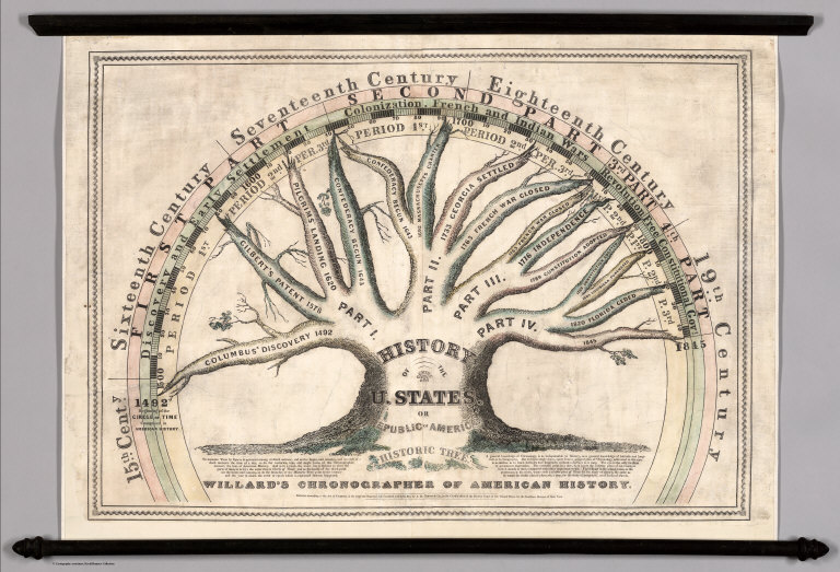
- 1 media/6700000.jpg 2020-05-01T06:47:37-07:00 Tamara Shreiner 72eaa2d1ba1352b75b8a8da73e879a4ceb510ae0 Willard's Chronographer of American History (1845) Carolyn Corey 9 This educational wall map created in 1845 summarizes the history of the United States in the form of a tree. Time is represented using the metaphor of a clock, circling in a timeline around the treetop. The graphic covers the period from Columbus's "discovery" in 1492 until the present. With this format, emphasis is placed on historical context of one event compared to another; to know the relative place of an event in history compared to others. This data visualization can be viewed at https://www.davidrumsey.com/luna/servlet/s/3e33vr plain 2020-07-31T07:18:46-07:00 Carolyn Corey a3be5ecac5feb3465ab045c4d8c977721103c688
- 1 2020-06-22T18:45:48-07:00 Carrie Finholm 6639ecc7d8d3786478af93b68ebed21d6d95960d Plan of Fort Henry and its Outworks (1862) Carrie Finholm 7 The Battle of Fort Henry which was fought during the American Civil War on February 6th, 1862 and was a very important victory for The Union. Fort Henry was known as a critical defense point for the Confederacy as it protected Nashville, Tennessee and the railroad route between Bowling Green, Kentucky and Memphis. Fort Henry's surrender also allowed the Tennessee River to open to the Union traffic south of the Alabama border. Established by the United States Army, the map displayed is upon cloth with pen-and-ink. The profile of the fort, the ditch full of water, and the profile of the rifle pits are also featured on the cloth map. plain 2020-07-21T12:56:21-07:00 Carrie Finholm 6639ecc7d8d3786478af93b68ebed21d6d95960d
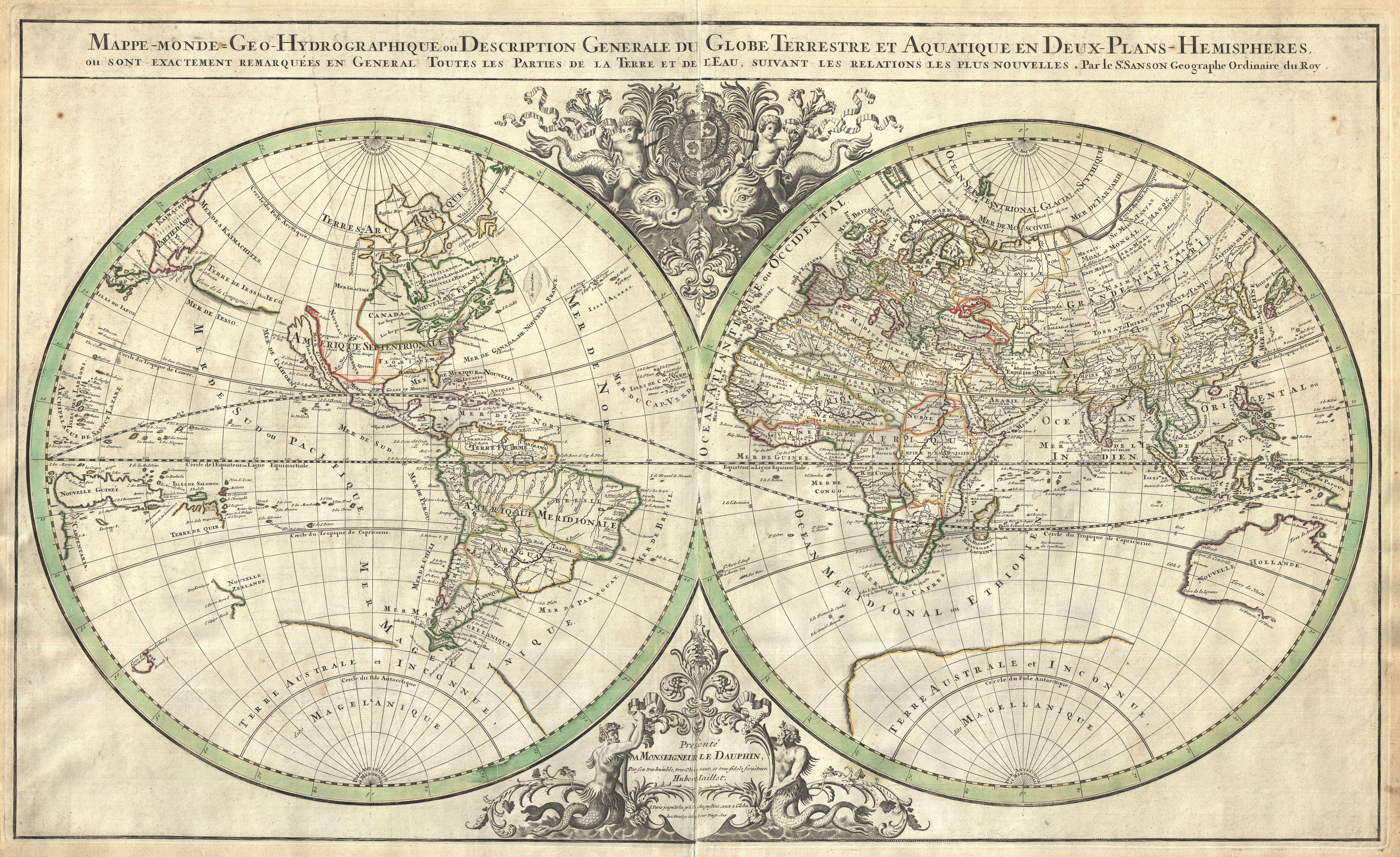
- 1 2020-05-04T11:33:57-07:00 Tamara Shreiner 72eaa2d1ba1352b75b8a8da73e879a4ceb510ae0 Sanson Map of the World on Hemisphere Projection (1659) Carolyn Corey 7 Nicolas Sanson d'Abbeville was a celebrated Paris cartographer. This map created in 1659 gives an overview of the general divisions of the globe. The topography of the landmasses fades into the background, although it contains a few curiosities. For example, Korea and California are shown as islands. In the foreground the two hemispheres show the system of meridians, latitudes, equator, tropics, and climatic zones, which served the contemporary geographers as divisions and description of the surface of the Earth. The title of the map indicates that the coordinate system also correlates to the division of the imagined celestial sphere, which astronomers used to map out the position of celestial bodies. plain 2020-07-22T19:36:57-07:00 Carolyn Corey a3be5ecac5feb3465ab045c4d8c977721103c688
- 1 2020-06-22T13:32:00-07:00 Carrie Finholm 6639ecc7d8d3786478af93b68ebed21d6d95960d Map of the Battle Field of Gettysburg (1863) Carrie Finholm 7 The Battle of Gettysburg, which involved the largest number of casualties of the entire Civil War, was known as the war's turning point. Right after the battle, this map was made in 1863 to showcase the Battle of Gettysburg. This particular map was based off of Gouverneur K. Warren's map of the Gettysburg Battle Field, but with the addition of hachures. The names of land owners are printed in the color red. The troop positions are not noted. This image can be found at https://www.loc.gov. plain 2020-07-21T13:46:15-07:00 Carrie Finholm 6639ecc7d8d3786478af93b68ebed21d6d95960d
- 1 2020-05-01T11:56:34-07:00 Tamara Shreiner 72eaa2d1ba1352b75b8a8da73e879a4ceb510ae0 Universal Cosmography (1507) Carolyn Corey 7 This map is a key work in the development of scientific geography. There is only one surviving example of this woodcut, which is made up of 12 individual pages. The German cartographers Martin Waldseemüller and Matthias Ringmann decided to call the new (to Europeans, at least) continent in the west "America," after the first name of the seafarer Amerigo Vespucci. This unusual visualization came about because Waldseemüller extended Ptolemy's second projection (which was conceived for a smaller circumference of the Earth) in order to integrate the Pacific Ocean and North and South America. At the top, Ptolemy and Vespucci are pictured. plain 2020-07-21T18:48:49-07:00 Carolyn Corey a3be5ecac5feb3465ab045c4d8c977721103c688
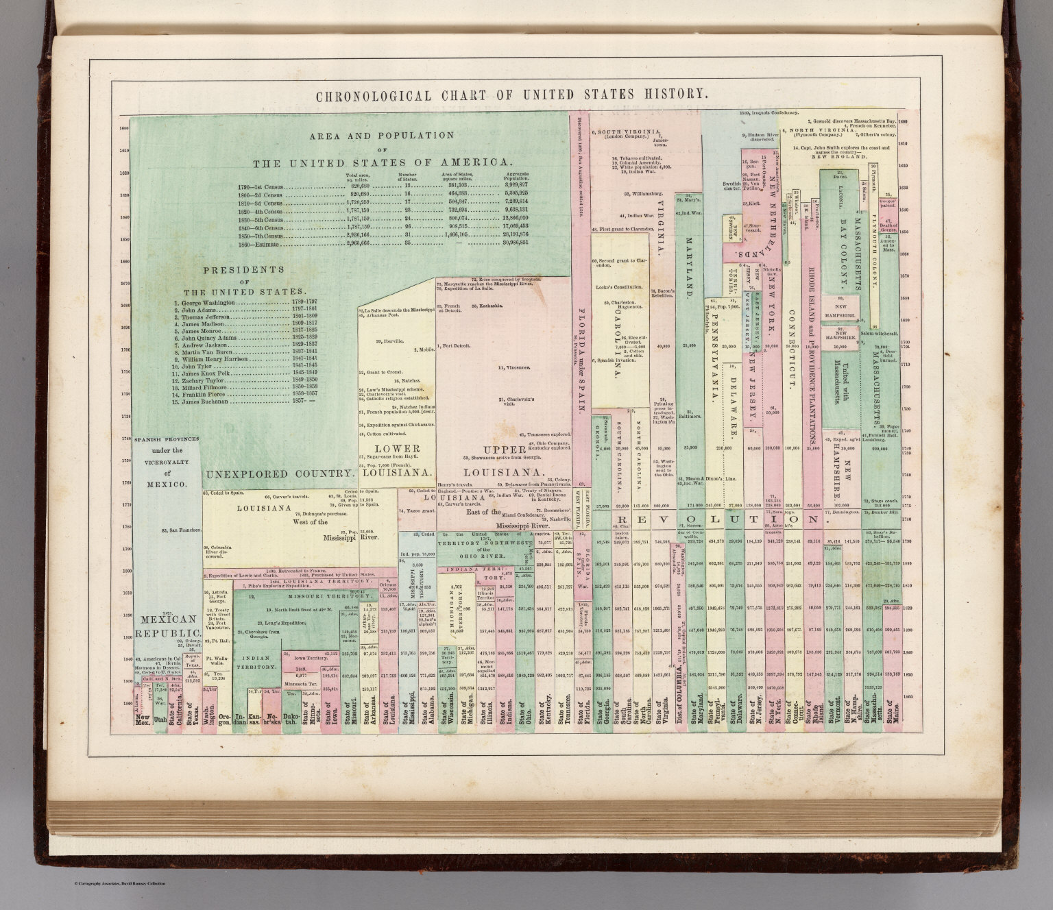
- 1 media/1690049_thumb.jpg 2020-05-29T14:49:23-07:00 Carrie Finholm 6639ecc7d8d3786478af93b68ebed21d6d95960d Chronological Chart of United States History (1859) Tamara Shreiner 7 This shows a very unique chart/timeline of chronological events that happened in United States history up until 1859. G. W. Colton-- the creator of this chart--included area and population of The United States from the census', list of presidents, and the history of each states' foundation. The chart also contains significant events that happened as well. plain 2020-11-06T11:29:38-08:00 Tamara Shreiner 72eaa2d1ba1352b75b8a8da73e879a4ceb510ae0
- 1 media/maps1_29944_medium_thumb.jpg 2020-05-08T06:56:59-07:00 Tamara Shreiner 72eaa2d1ba1352b75b8a8da73e879a4ceb510ae0 Locations and Wanderings of the Aboriginal Tribes (1828) Carolyn Corey 6 The American pedagogue Emma Willard strove to reform educational methods. In addition to founding her own schools, she published teaching materials, such as Willard's History of the United States, or Republic of America, which was accompanied by an atlas of 12 maps. In the preface she emphasized how vital it is to convey to students a stable framework for understanding complex themes. The clear arrangement of facts and visual devices should make it possible for students to acquire and categorize further knowledge at a later time. This example shows the historical state of North America before European colonization. The locations of various tribes of aboriginal peoples are illustrated, shown on the map as ovals, with their migrations and movements indicated by lines and arrows. This image can also be viewed at https://digital.libraries.psu.edu/digital/collection/maps1/id/29944/. plain 2020-07-31T07:08:48-07:00 Carolyn Corey a3be5ecac5feb3465ab045c4d8c977721103c688
- 1 2020-05-01T11:39:03-07:00 Tamara Shreiner 72eaa2d1ba1352b75b8a8da73e879a4ceb510ae0 Map Showing the Distribution of the Slave Population of the Southern States of the United States (1861) Carrie Finholm 6 Based on the U.S. Census of 1860, this choropleth map represents the distribution of the enslaved population in the Southern states, using a fine-tuned system of shading in nine classes. Each county is labeled by its name and its respective percentage of slaves. plain 2020-07-21T11:55:28-07:00 Carrie Finholm 6639ecc7d8d3786478af93b68ebed21d6d95960d
- 1 2020-06-22T11:02:30-07:00 Carrie Finholm 6639ecc7d8d3786478af93b68ebed21d6d95960d A Map of Lewis and Clark's Track Across the Western Portion of North America from the Mississippi to the Pacific Ocean (1814) Carrie Finholm 6 Created in 1814, this is a map contributed by William Clark, Samuel Lewis, Samuel Harrison, and Bradford and Inskeep that displays the journey Lewis and Clark made across the United States to the Pacific Ocean. The map shows the elevation of mountain ranges, rivers that they traveled on, and territories occupied. Longitude and latitude lines are also established on the sidelines of the map. This image can be found at https://www.loc.gov. plain 2020-07-20T19:08:33-07:00 Carrie Finholm 6639ecc7d8d3786478af93b68ebed21d6d95960d
- 1 2020-06-09T13:18:53-07:00 Carrie Finholm 6639ecc7d8d3786478af93b68ebed21d6d95960d New England: The Most Remarqueable Parts Thus Named by the High and Mighty Prince Charles (1624) Carolyn Corey 6 Based on John Smith's voyage in 1614, which was reissued at least 9 times, this map contains a later issue that was published in 1624 in Gerard Mercator's great atlas of the world, which regards the discovery of New England. On the upper left hand corner is a portrait of Captain John Smith himself. In the center of the map holds the Council of New England arms. Directly below, a compass rose. This image can be found at https://collections.leventhalmap.org/. plain 2020-07-22T19:29:12-07:00 Carolyn Corey a3be5ecac5feb3465ab045c4d8c977721103c688
- 1 2020-06-23T11:03:07-07:00 Carrie Finholm 6639ecc7d8d3786478af93b68ebed21d6d95960d Progress of the Civil War (1861-1864) Mark Guzdial 5 Shown throughout 4 different maps is the progress of the Civil War between the years of 1861 and 1864. John Formby, the creator of these maps, provided a key and explanation on the left hand side for the reader to decipher the meaning behind the different symbols. The numbers of the maps 2-5 each correlate with a different year of the American Civil War. At the very top of the maps is a scale that is 125 miles to one inch. plain 2020-12-19T20:09:16-08:00 Mark Guzdial 12293646cf3f9238a8ffe62e740f7f92aafe60a3
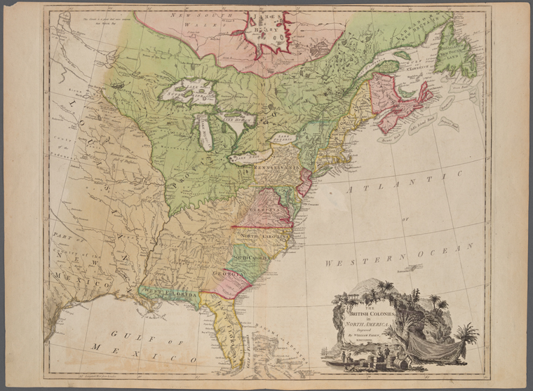
- 1 media/nypl.digitalcollections.510d47db-c691-a3d9-e040-e00a18064a99.001.w_thumb.jpg 2021-03-26T13:20:43-07:00 Tamara Shreiner 72eaa2d1ba1352b75b8a8da73e879a4ceb510ae0 William Faden, "The British Colonies in North America" (1777) Mark Guzdial 5 William Faden was an English cartographer who served as the royal geographer to King George III. A royal geographer’s job was to publish and supply parliament and the crown with maps. The map depicts the British colonies in North America in 1777. plain 2021-03-27T13:52:43-07:00 Mark Guzdial 12293646cf3f9238a8ffe62e740f7f92aafe60a3
- 1 2020-06-09T13:52:50-07:00 Carrie Finholm 6639ecc7d8d3786478af93b68ebed21d6d95960d 7th Map to Accompany Willards History of United States (1776) Carrie Finholm 5 Created by Emma Willard, this map covers the colonies and the routes of ships in 1776. The colonies are highlighted and outlined in different colors on the map to show their boundaries at that time. The map also magnifies certain locations that were significant and events such as the signing of the Declaration of Independence in 1776. The ships routes on the map have dates and have dashed lines to represent their traveled routes. This image can be found at https://collections.leventhalmap.org. plain 2020-07-20T18:21:58-07:00 Carrie Finholm 6639ecc7d8d3786478af93b68ebed21d6d95960d
- 1 2020-06-09T17:13:04-07:00 Carrie Finholm 6639ecc7d8d3786478af93b68ebed21d6d95960d Plan of the Investment of York and Gloucester (1782) Carrie Finholm 5 Sebastian Bauman-- the creator of this map-- was a topographical engineer who immigrated to North America from Germany. He designed and created this map very shortly after the Battle of Yorktown when the British surrendered. This was the very first map published that was dedicated to the battle and to the famous general, George Washington. The plan illustrates the British troops in red. The French and American troops are colored in yellow and blue. The passage at the bottom of the map contains the description of the battle. This image can be found at https://collections.leventhalmap.org. plain 2020-07-20T18:26:19-07:00 Carrie Finholm 6639ecc7d8d3786478af93b68ebed21d6d95960d
- 1 2020-05-08T10:49:28-07:00 Tamara Shreiner 72eaa2d1ba1352b75b8a8da73e879a4ceb510ae0 New York and Erie Railroad Diagram (1855) Carolyn Corey 5 This diagram comes from the early days of the railroad and shows the organizational structure of the New York and Erie Railroad Company. Like many early rail companies they had the challenge of securely managing the traffic going in both directions on single tracks and avoiding deadly collisions. Those responsible for the lines in the company used the telegraph to exchange current traffic information. The diagram illustrates the strict lines of communication that had to be observed to prevent fatal mistakes. The long main branches of the diagram represent the fives lines of the railroad company, which are rooted in the circular structure of management. The numerous round leaves on all the various branches stand for individual employees. plain 2020-07-31T07:21:47-07:00 Carolyn Corey a3be5ecac5feb3465ab045c4d8c977721103c688
- 1 2020-04-30T08:16:40-07:00 Tamara Shreiner 72eaa2d1ba1352b75b8a8da73e879a4ceb510ae0 History of the Civil War in the United States, 1860-1865 (1897) Carolyn Corey 5 The enormous popularization of visualization methods toward the end of the 19th century generated numerous projects of sometimes exuberant creativity. Here the complex history of the U.S. Civil War is summarized in a table--from the value of the currency and number of troops to crucial military events. The ascending timeline is reminiscent of a staff gauge for measuring river levels. plain 2020-07-31T20:50:36-07:00 Carolyn Corey a3be5ecac5feb3465ab045c4d8c977721103c688
- 1 2020-06-22T12:09:01-07:00 Carrie Finholm 6639ecc7d8d3786478af93b68ebed21d6d95960d Map Showing the Distribution of Wealth (1874) Carolyn Corey 5 Based off the ninth census conducted in 1870, this map displays the distribution of wealth within the United States. With the help from Francis A. Walker and information from the United States Census Office, data was able to be collected to display this information. A scale is provided on the right hand side to reveal what the colors of wealth represent. The bottom center contains an explanation of some of the key features of the map. According to the map, the blue lines indicate the boundaries of groups of population. The figures in blue express the the number of inhabitants to the square mile found in each group. The map also explains in the description below that the shaded lines in blue reveal the outside limit of a population of 2 or more to the square mile. The shading points towards the regions which have a population of less than 2 to square mile. This image can be found at https://www.loc.gov/resource/g3701gm.gct00008/?sp=83. plain 2020-07-31T20:41:23-07:00 Carolyn Corey a3be5ecac5feb3465ab045c4d8c977721103c688
- 1 2020-06-09T17:45:28-07:00 Carrie Finholm 6639ecc7d8d3786478af93b68ebed21d6d95960d Whereon is Laid Down the Missouri, Jeffersons, Lewis's, Clarks, and the Columbia, Rivers, from the Mississippi to the Pacific Ocean (1807) Carrie Finholm 5 After the Louisiana Purchase, Lewis and Clark were sent on an expedition to explore the western portion of the United States. This map, created by Meriwether Lewis himself, portrayed the journey that him and William Clark took. The map specializes in the northern quadrant of the United States from east of the Mississippi River and to the Pacific Ocean. The red ink was used for indicating and locating territories of Indian tribes. The black ink was used for inscriptions, place names, for both latitude and longitude, and for borders. The blue was used to display sources of water such as rivers, lakes, and the ocean. This image can be found at https://www.leventhalmap.org. plain 2020-07-20T18:57:06-07:00 Carrie Finholm 6639ecc7d8d3786478af93b68ebed21d6d95960d
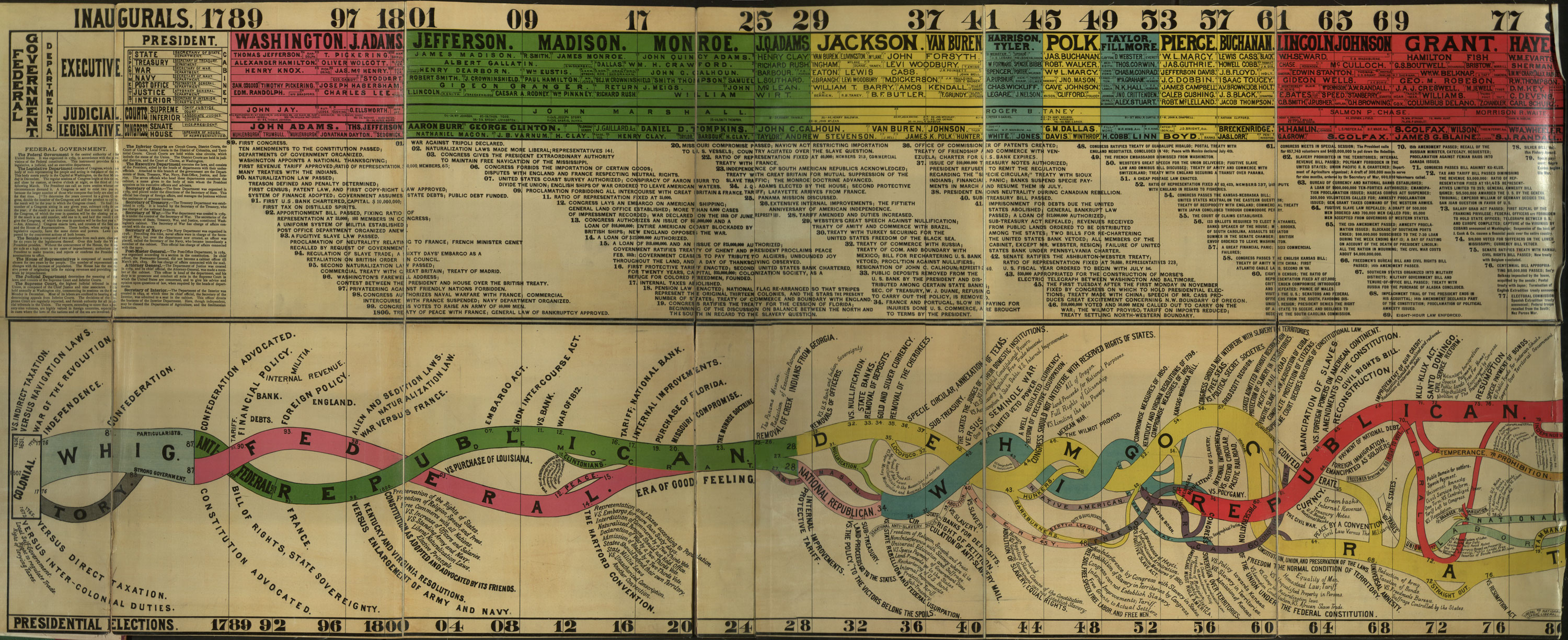
- 1 2020-05-26T07:16:54-07:00 Carolyn Corey a3be5ecac5feb3465ab045c4d8c977721103c688 Conspectus of the History of Political Parties (1880) Carolyn Corey 5 Timelines began to gain popularity in the nineteenth century and became very prominent in everyday life. This “Conspectus of the History of Political Parties” helps to consolidate political history into one data visualization. A “conspectus” is a term from the 19th century, meaning “a comprehensive mental survey.” In this data visualization, the various presidencies are outlined at the top by year and color coded in accordance with the outlined political party “rivers” at the bottom, as well as other important members of the cabinet, the Supreme Court, and other federal political positions. These demonstrate the power held by each political party based on the thickness of the river. Scattered throughout the timeline are various events that occurred, weaved throughout the rivers. This was created by Walter R. Houghton, published by Grander, Davis & Co. in 1880, and lithographed by William B. Burford in Indiana. This data visualization can be found at http://www.mappingthenation.com/blog/charting-the-flow-of-political-power/ plain 2020-07-31T20:44:18-07:00 Carolyn Corey a3be5ecac5feb3465ab045c4d8c977721103c688
- 1 2020-06-09T14:09:03-07:00 Carrie Finholm 6639ecc7d8d3786478af93b68ebed21d6d95960d An Accurate Map of the United States of America (1783) Tamara Shreiner 5 This map which was created by John Russell after the Treaty of Paris (peace) to show the newly proclaimed area in the land now known as the United States of America. The map displays the new and approved states and territory conquered after the American Revolution. This image can be found at https://www.leventhalmap.org/. plain 2020-11-17T09:27:10-08:00 Tamara Shreiner 72eaa2d1ba1352b75b8a8da73e879a4ceb510ae0
- 1 2020-07-01T09:09:17-07:00 Carolyn Corey a3be5ecac5feb3465ab045c4d8c977721103c688 Plan of New Orleans (1764) Carrie Finholm 4 This data visualization was created by Jacques Nicolas Bellin, who lived from 1703-1772. It is commonly known that New Orleans belonged to France, and as a result this map and its descriptions are in French also. Laid out are the various blocks in the city, and letters with labels at the top correspond to those on the map, signaling what that area will be used for. On the bottom is “Fleuve Mississipi”, or the Mississippi River. plain 2020-07-20T18:11:39-07:00 Carrie Finholm 6639ecc7d8d3786478af93b68ebed21d6d95960d
- 1 2020-05-10T06:49:19-07:00 Tamara Shreiner 72eaa2d1ba1352b75b8a8da73e879a4ceb510ae0 The Discovery of the East Coast (1856) Carrie Finholm 4 This map dispenses almost completely with representing geographic features. Here German travel writer Johann Georg Kohl visualized historical explorations along the east coast of the United States. This and two other maps, which show the Gulf of Mexico and the Pacific coast, belong to a monumental study that Kohl carried out for the U.S. coastal and Geodetic Survey. In this hand-colored map the coast is traced with differently colored lines, each standing for an expedition. Unfortunately the range of colors does not logically correlate to the successive periods of time. This map is however notable in its goal of creating a visual representation of the series of expeditions and the ever increasing knowledge that resulted. plain 2020-07-21T11:42:00-07:00 Carrie Finholm 6639ecc7d8d3786478af93b68ebed21d6d95960d
- 1 2020-06-23T12:36:50-07:00 Carrie Finholm 6639ecc7d8d3786478af93b68ebed21d6d95960d Gettysburg and Vicinity, Showing the Lines of Battle (1863) Carrie Finholm 4 A significant Union victory, the Battle of Gettysburg was considered a turning point in the American Civil War with also the most causalities taken. James T. Long did a substantial job at displaying each side in different colors- the Union in blue and the Confederacy in red on the map. A key for further explanation of color is provided in the bottom left hand corner. The map also includes roads, houses, names of residents, fences, railroads, vegetation, and drainage. There is also some information on the right hand side that shows the site of General Gregg's calvary operations. plain 2020-07-21T13:20:45-07:00 Carrie Finholm 6639ecc7d8d3786478af93b68ebed21d6d95960d
- 1 2020-06-22T10:52:10-07:00 Carrie Finholm 6639ecc7d8d3786478af93b68ebed21d6d95960d Reynold's Political Map of the United States (1856) Carrie Finholm 4 This map was designed to display the comparative area of free and slave states and the territory open to slavery or freedom by the repeal of the Missouri Compromise. This map depicts free states in red, slave states in black, and territories in green. Kansas is intentionally left neutral to emphasize that the fate of that state was in question. This map is persuasive, attempting to convince viewers that free states in the Northeast were in danger of being overwhelmed by “Slave Power” in the South. There are multiple charts of statistics at the bottom of the map, based on the Census of 1850. They convey the message that the southern states were able to advance their agenda because they had more power at the federal level, even though on demographic, cultural, and economic measures, the North was superior. plain 2020-07-21T11:48:44-07:00 Carrie Finholm 6639ecc7d8d3786478af93b68ebed21d6d95960d
- 1 2020-06-23T11:15:34-07:00 Carrie Finholm 6639ecc7d8d3786478af93b68ebed21d6d95960d Battle of Bull Run (1861) Carrie Finholm 4 Originally created in 1910 by John Formby and John Murray, this map displays the Battle of Bull Run based in 1861-the first major battle and victory for the Confederacy. The bottom left hand corner is a key that explains the symbols that represent both the Union and the Confederacy. The letters on the map also have meaning for what they stand for. A scale is provided at the very bottom of the map for guidance. plain 2020-07-21T12:08:15-07:00 Carrie Finholm 6639ecc7d8d3786478af93b68ebed21d6d95960d
- 1 2020-05-10T16:15:35-07:00 Tamara Shreiner 72eaa2d1ba1352b75b8a8da73e879a4ceb510ae0 The Complete Map of Richmond and its Fortifications (1863) Carrie Finholm 4 Th city of Richmond, Virginia served as the capital of the Confederacy during the American Civil War. As it was of central importance both strategically and politically, the city was one of the most important targets of the Union army over the course of the war. This situation is represented in this map, which was published in Boston. It shows the city's surroundings, with residential areas, rivers, swamps, and roads. Around the city, the Confederate defensive positions and their striking distances are charted. The early use of concentric circles for indicating distances is especially interesting, as is the note in the title attesting to the accuracy of the information--even though it was published in the North it originated from an engineer who deserted the Confederacy. plain 2020-07-22T18:13:34-07:00 Carrie Finholm 6639ecc7d8d3786478af93b68ebed21d6d95960d
- 1 2020-05-15T06:20:29-07:00 Tamara Shreiner 72eaa2d1ba1352b75b8a8da73e879a4ceb510ae0 Acres of land owned by Negroes in Georgia (1900) Carolyn Corey 4 The creator of this visualization--W.E.B. Du Bois-- was a sociologist and well-known leader in the black civil rights movement. For the World's Fair in Paris in 1900 he designed an exhibition on the black population in the United States with his former classmate Thomas J. Calloway. In just four months, and with financial support from the U.S. Congress, Calloway and Du Bois produced a presentation comprised of a great number of books and photographs. Du Bois's particular contribution together with students, was to prepare several dozen display boards presenting sociological data on the lives of the black population through graphs and charts. It is clear that Du Bois modeled some of the charts from statistical atlases at the U.S. Census Office, for example; in others he developed his own modes of visualization. This particular data visualization displays information of how many acres of land was owned by negroes in Georgia from the year of 1874-1899. plain 2020-07-31T20:51:36-07:00 Carolyn Corey a3be5ecac5feb3465ab045c4d8c977721103c688
- 1 2020-06-23T11:31:02-07:00 Carrie Finholm 6639ecc7d8d3786478af93b68ebed21d6d95960d Battle of Shiloh (1862) Carrie Finholm 4 Originally created in 1910 by John Formby and John Murray, this map displays the Battle of Shiloh based in 1862-a crucial victory for the Union during the Civil War. Near the center top, there is a key explaining what the symbols represent. The different colored and shaded in boxes correlate with different Union morning and evening attacks and morning attacks made by the Confederacy. plain 2020-07-21T12:10:53-07:00 Carrie Finholm 6639ecc7d8d3786478af93b68ebed21d6d95960d
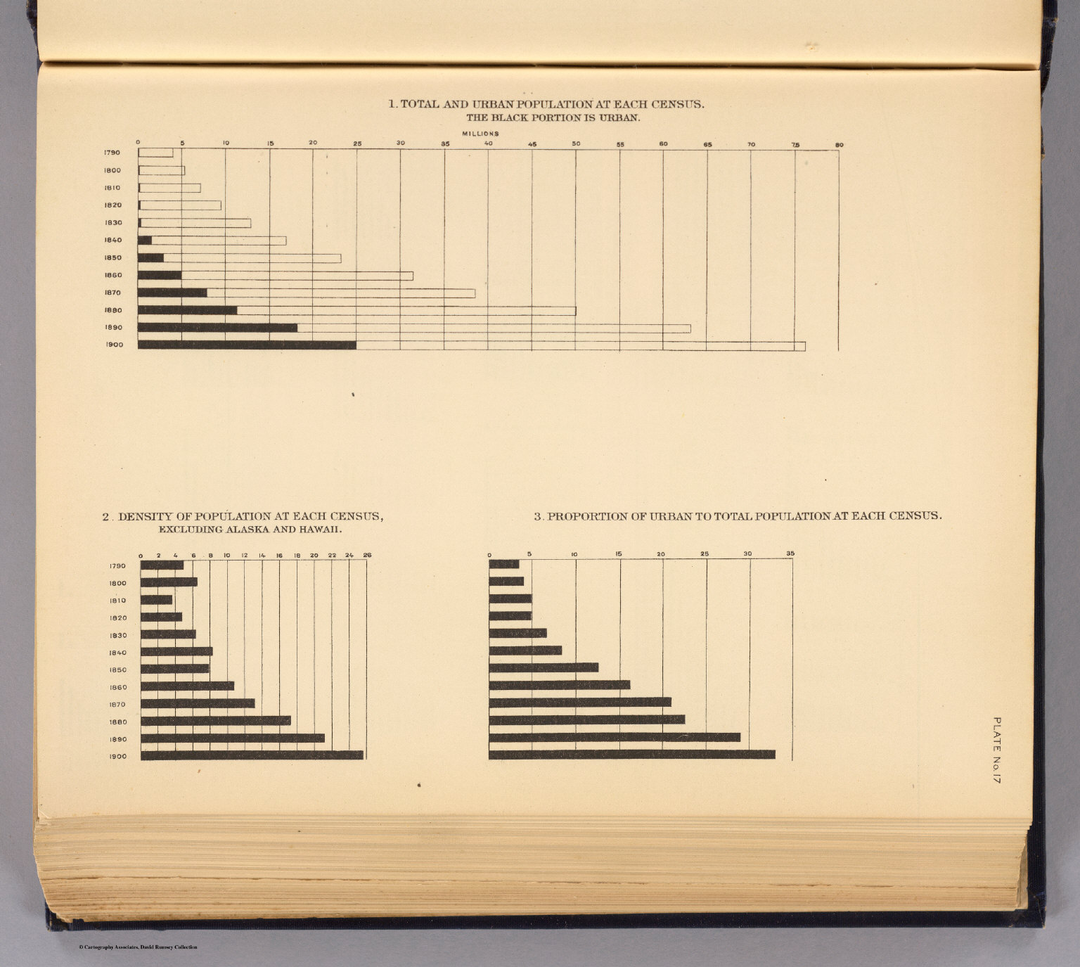
- 1 media/2152017_thumb.jpg 2020-05-29T14:10:00-07:00 Carrie Finholm 6639ecc7d8d3786478af93b68ebed21d6d95960d United States Census from 1790-1900 of Total and Urban Population, Density and Proportion (1903) Carolyn Corey 4 Taken from the Census Office in 1903, this data visualization published by Henry Gannett contains a statistical diagram of 3 different graphs. The first graph shows the total and urban population at each census from 1790-1900. The black portion represents the urban population. The second graph displays the density of population at each census, excluding Alaska and Hawaii. The third graph indicates the proportion of urban to total population at each census. This image can be found at https://www.davidrumsey.com/. plain 2020-07-31T20:53:24-07:00 Carolyn Corey a3be5ecac5feb3465ab045c4d8c977721103c688
- 1 2020-06-23T12:12:48-07:00 Carrie Finholm 6639ecc7d8d3786478af93b68ebed21d6d95960d Battle of the Antietam or Sharpsburg (1862) Carrie Finholm 4 Originally created in 1910 by John Formby and John Murray, this map displays the Battle of Antietam or Sharpsburg based in 1862- one of the most important events of the Civil War as it ended the Confederate invasion of Maryland and was a major victory for the Union. The battle also resulted in Abraham Lincoln issuing the Preliminary Emancipation Proclamation on September 22, 1862. The map has a small key near the bottom right hand corner. A scale is also provided at the bottom center of the map. plain 2020-07-21T12:18:34-07:00 Carrie Finholm 6639ecc7d8d3786478af93b68ebed21d6d95960d
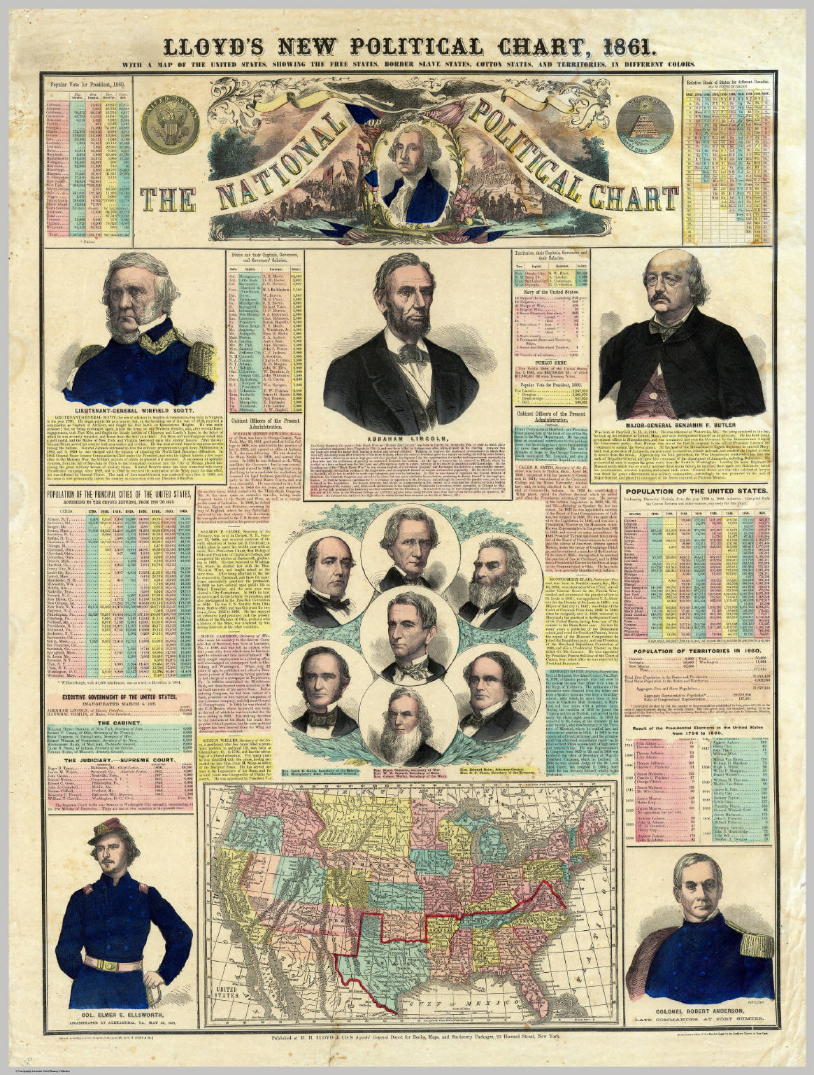
- 1 media/00094177_thumb.jpg 2020-05-29T18:56:20-07:00 Carrie Finholm 6639ecc7d8d3786478af93b68ebed21d6d95960d The National Political Chart (1861) Carrie Finholm 4 This chart made in 1861 by H.H. Lloyd displays many various sources in information such as a map of the United States showing the free states, border slave states, cotton states, and territories. Many portraits, biographies, and statistics are also included on the chart. This image can be found at https://www.davidrumsey.com/. plain 2020-07-21T12:48:24-07:00 Carrie Finholm 6639ecc7d8d3786478af93b68ebed21d6d95960d
- 1 2020-06-23T10:38:12-07:00 Carrie Finholm 6639ecc7d8d3786478af93b68ebed21d6d95960d A General Map of the Middle British Colonies in America (1771) Carrie Finholm 3 Carington Bowles and Lewis Evans--contributors to the creation of this map-- set to make a general map of the middle British colonies in America at the time of 1771. The map includes several texts around it, historical notes, distance charts, and a sketch of the of the remaining part of Ohio. The map also displays some of the Great Lakes on it. plain 2020-07-20T18:16:23-07:00 Carrie Finholm 6639ecc7d8d3786478af93b68ebed21d6d95960d
- 1 2020-05-01T06:57:24-07:00 Tamara Shreiner 72eaa2d1ba1352b75b8a8da73e879a4ceb510ae0 Trade Wind Chart of the Atlantic Ocean (1885) Carolyn Corey 3 Matthew Fontaine Maury documented the seasonal shifts of the trade winds across the Atlantic. Each column comprises five degrees of longitude and charts the 12 months of the year starting with December. Horizontal lines refer to latitudes but do not form a consistent grid. plain 2020-07-31T20:46:00-07:00 Carolyn Corey a3be5ecac5feb3465ab045c4d8c977721103c688
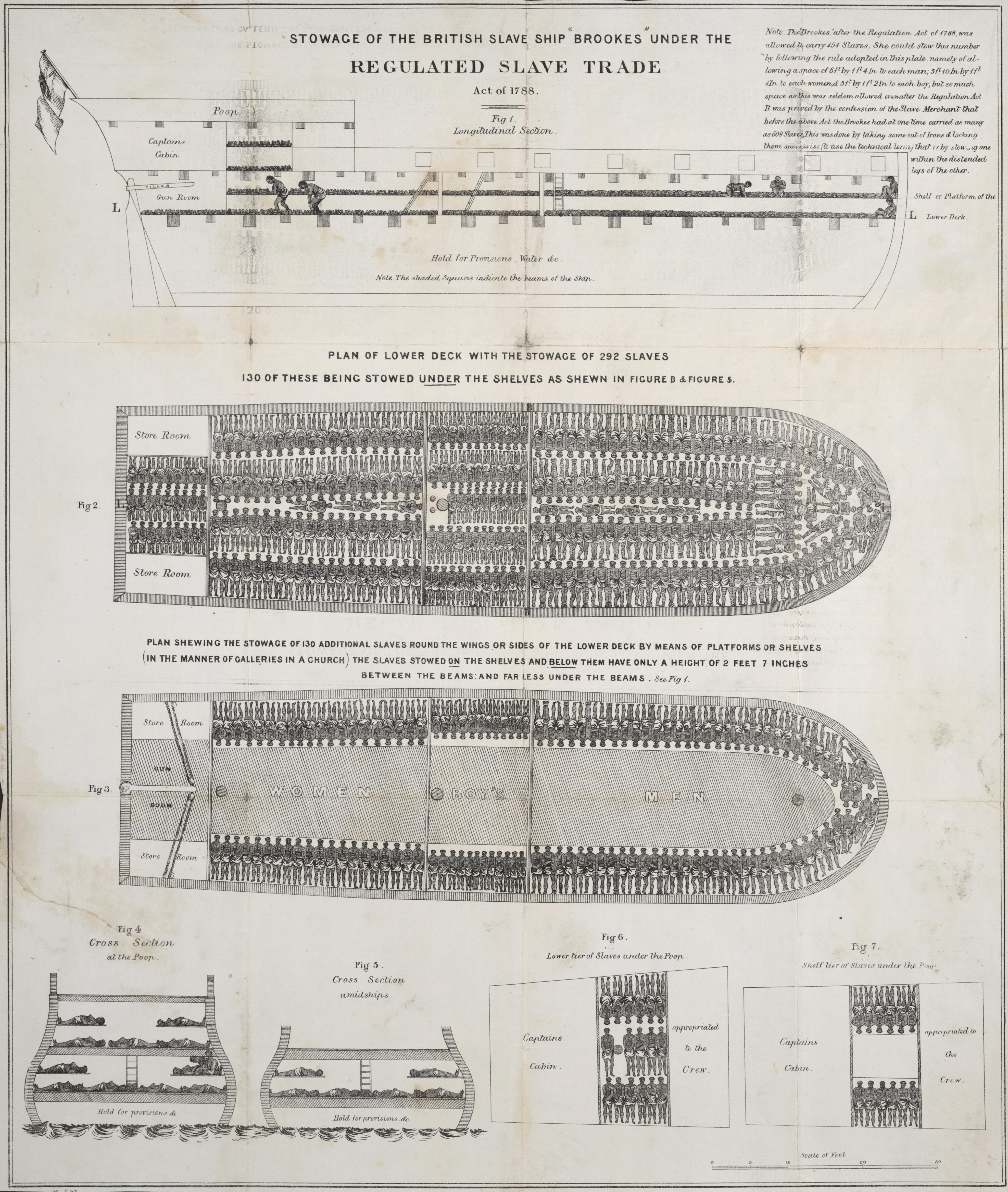
- 1 2020-05-04T13:13:28-07:00 Tamara Shreiner 72eaa2d1ba1352b75b8a8da73e879a4ceb510ae0 Stowage of the British Slave Ship Brookes (ca. 1790) Carrie Finholm 3 This visualization is considered iconic of the anti-slavery movement that formed in the late 18th century Great Britain. This work is attributed to the English abolitionist Thomas Clarkson who tirelessly collected and published reports and records of the inhumanity of the slave trade. The artist who rendered the illustration is unknown. There were many variations of the graphic and it found broad distribution as a single printed page and in newspapers. It shows various sections of a transport ship and the "stowage" of enslaved people in the lower deck. Special attention was paid to the extreme lack of space that was allotted to each person for a trip that lasted many weeks. plain 2020-07-20T18:41:32-07:00 Carrie Finholm 6639ecc7d8d3786478af93b68ebed21d6d95960d
- 1 2020-05-11T06:18:42-07:00 Tamara Shreiner 72eaa2d1ba1352b75b8a8da73e879a4ceb510ae0 Seat of War in America (1863) Carrie Finholm 3 This map on the American Civil War was published in London and demonstrates the public interest in events overseas that existed in London, as well as the rest of Europe. It shows the theater of war in eastern Virginia and the bordering regions of Maryland and Pennsylvania, but does not illustrate the specific point in time. Roads, military positions, and localities are printed in a relatively rough quality, without many graphic details. The capital of the United States, Washington, D.C., and Richmond, the capital of the Confederacy, are highlighted. Places in which battles have taken place are underlined in red. At the lower left other maps on the current events of the war are advertised. plain 2020-07-22T18:34:02-07:00 Carrie Finholm 6639ecc7d8d3786478af93b68ebed21d6d95960d
- 1 2020-06-22T12:34:43-07:00 Carrie Finholm 6639ecc7d8d3786478af93b68ebed21d6d95960d Map Showing, In Five Degrees of Density, the Distribution, Within the Territory (1874) Carolyn Corey 3 Based off the ninth census conducted in 1870, this map displays the five degrees of density, the distribution, within the territory of the United States east of the 100th meridian, of that portion of the population which is, in whole, or in part of, foreign parentage. With the help from Francis A. Walker and information from the United States Census Office, data was able to be collected to display this information. A scale is provided on the right hand side to reveal what the colors of the map represent. The bottom center contains an explanation of some of the key features of the map. According to the map, the blue lines indicate the boundaries of groups of population. The figures in blue express the the number of inhabitants to the square mile found in each group. The map also explains in the description below that the shaded lines in blue reveal the outside limit of a population of 2 or more to the square mile. The shading points towards the regions which have a population of less than 2 to square mile. This image can be found at https://www.loc.gov. plain 2020-07-31T20:42:20-07:00 Carolyn Corey a3be5ecac5feb3465ab045c4d8c977721103c688
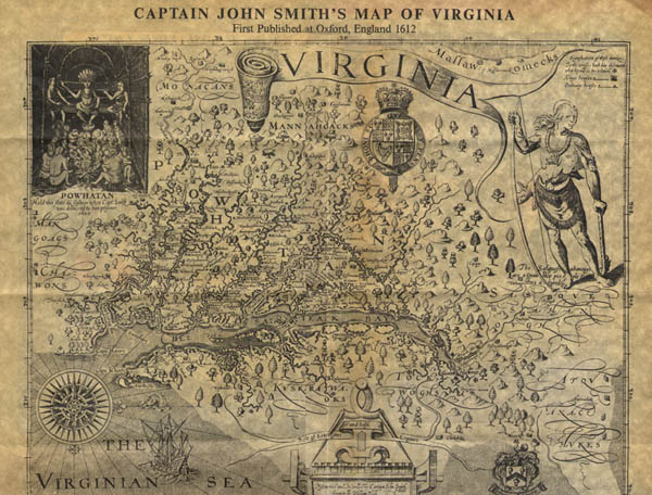
- 1 2020-06-13T18:30:14-07:00 Carrie Finholm 6639ecc7d8d3786478af93b68ebed21d6d95960d Captain John Smith's Map of Virginia (1612) Carrie Finholm 3 Originally published in London in 1612 and then in the 1612 Oxford publication, Captain John Smith created a map of Virginia which would be known as a very common and influential map. Many of the places named by John Smith still remain in use today. plain 2020-07-20T17:36:21-07:00 Carrie Finholm 6639ecc7d8d3786478af93b68ebed21d6d95960d
- 1 2020-05-11T06:51:39-07:00 Tamara Shreiner 72eaa2d1ba1352b75b8a8da73e879a4ceb510ae0 Population of the United States from 1790 to 1820 (1874) Carrie Finholm 3 With its numerous diagrams and thematic maps, the Statistical Atlas of the United States, published in 1874 by Francis Amasa Walker, is a masterwork of the 19th century statistical graphics. This example shows the "progress of the nation" in a series of four maps that document the population growth in 10-year stages from 1790 onward. The population densities of the inhabited territories (excluding indigenous peoples as they were not taken into account in the censuses) were broken down into five classes. In addition the authors made great efforts to calculate the respective geographic "Centre of Population," evidently because this concept played an important role in the public debates of the time. Represented by a star, this center wandered from the northern Chesapeake Bay in 1790 steadily westward over time. plain 2020-07-22T18:39:01-07:00 Carrie Finholm 6639ecc7d8d3786478af93b68ebed21d6d95960d
- 1 2020-06-22T13:00:11-07:00 Carrie Finholm 6639ecc7d8d3786478af93b68ebed21d6d95960d Chart Showing the Principal Constituent Elements of the Population of Each State (1874) Carolyn Corey 3 Based off of the results of the ninth census in 1870, this chart presents the principal constituent elements of the population in each state. With the help from Francis A. Walker and information from the United States Census Office, data was collected to help display information upon the chart. The upper right hand corner shows a key to distinguish what each color represents on the chart. The size of the squares for each race and population of each state establishes the amount of people within that state. The upper left hand corner of the chart provides a further, more in depth explanation of the squares. This image can be found at https://www.loc.gov. plain 2020-07-31T20:43:25-07:00 Carolyn Corey a3be5ecac5feb3465ab045c4d8c977721103c688
- 1 2020-06-23T10:14:45-07:00 Carrie Finholm 6639ecc7d8d3786478af93b68ebed21d6d95960d An Accurate Map of North America Describing and Distinguishing the British, Spanish, and French Dominions on this Great Continent (1755) Carrie Finholm 3 Prior to almost 30 years before the start of the American Revolution, this map contributed by Emanuel Bowen, John Gibson, and Robert Sayer was made to describe and distinguish the British, Spanish, and French dominions of the North American continent. The map exhibits the present seat of war, the French encroachments, and the West India Islands which belonged and were possessed by several European princes and states. Historical notes and territorial claims are provided and a passage of land to California. The bottom right hand corner contains multiple different scales for the map and an explanation directly underneath it. plain 2020-07-20T18:05:22-07:00 Carrie Finholm 6639ecc7d8d3786478af93b68ebed21d6d95960d
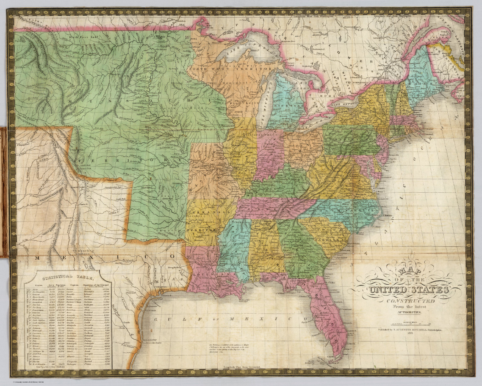
- 1 media/0511002_thumb.jpg 2020-05-29T12:38:33-07:00 Carrie Finholm 6639ecc7d8d3786478af93b68ebed21d6d95960d United States Map (1831) Carrie Finholm 3 Created by Samuel Augustus Mitchell, this colored map shows the states and territory of The United States in 1831. The Louisiana purchase previously happened about 28 years prior to this map, which is a perfect example to show the land obtained during this time frame. The land covered in green on the left of the map shows some of the land that was gained after the purchase took place. Rivers and mountain elevation are also shown. On the bottom left of the map, a statistical table is displayed. States and territories established by 1831 are listed including their area of square miles, population (in 1820), their capitals, and the population of the principal. This image can be found at https://www.davidrumsey.com/. plain 2020-07-20T19:27:33-07:00 Carrie Finholm 6639ecc7d8d3786478af93b68ebed21d6d95960d
- 1 2020-05-11T06:57:22-07:00 Tamara Shreiner 72eaa2d1ba1352b75b8a8da73e879a4ceb510ae0 United States Political History (1883) Carolyn Corey 2 Scribner's Statistical Atlas of the United States was published privately, but was based on the data from the 10th census of 1880. In addition to the numerous statistical maps and diagrams, it includes charts on political history. The page shown here traces the political evolution of the United States through the changing parties in power. Three horizontal sections present a timeline starting from the first U.S. presidential election in 1789 to the then present day. The height of each area of color correlates with the number of votes. It is color coded according to the respective party in power and each section represents a presidential term. The text gives information on the prevailing political themes of each presidency. plain 2020-07-31T20:45:07-07:00 Carolyn Corey a3be5ecac5feb3465ab045c4d8c977721103c688
- 1 2020-05-11T07:21:27-07:00 Tamara Shreiner 72eaa2d1ba1352b75b8a8da73e879a4ceb510ae0 Historical Geography (1888) Carolyn Corey 2 This work demonstrates impressively how maps have been used beyond their original purpose for the communication of political content; here, for example, offering an interpretation of U.S. history through a moral lens. The territory of the United States is overlaid with two strange trees oriented horizontally from east to west. As the rhetorical explanation states, this map deals with the two main influences on American history since the founding of the original colonies of Jamestown and Plymouth. The "good tree" of the North is rooted in the Bible and brings light to the West, where it ends in "immortality" in the Pacific. The dark and crooked tree of slavery in contrast soon buckles under, ending in "murder," "war," and finally "Hades," which is, without further explanation, located in Texas. plain 2020-07-31T20:47:49-07:00 Carolyn Corey a3be5ecac5feb3465ab045c4d8c977721103c688
- 1 media/lousiana purchase map_thumb.jpg 2021-03-28T20:25:33-07:00 Mark Guzdial 12293646cf3f9238a8ffe62e740f7f92aafe60a3 Map of the Louisiana Purchase Territory (1903) Mark Guzdial 2 The General Land Office was an independent government agency responsible for public domain land in the United States. The General Land Office oversaw the making of maps, surveying, and sale of public lands in the western United States. The General Land Office merged with the United States Grazing Service to become the Bureau of Land Management in 1946. The map shows the territory covered by the Louisiana Purchase. plain 2021-04-01T12:45:50-07:00 Mark Guzdial 12293646cf3f9238a8ffe62e740f7f92aafe60a3
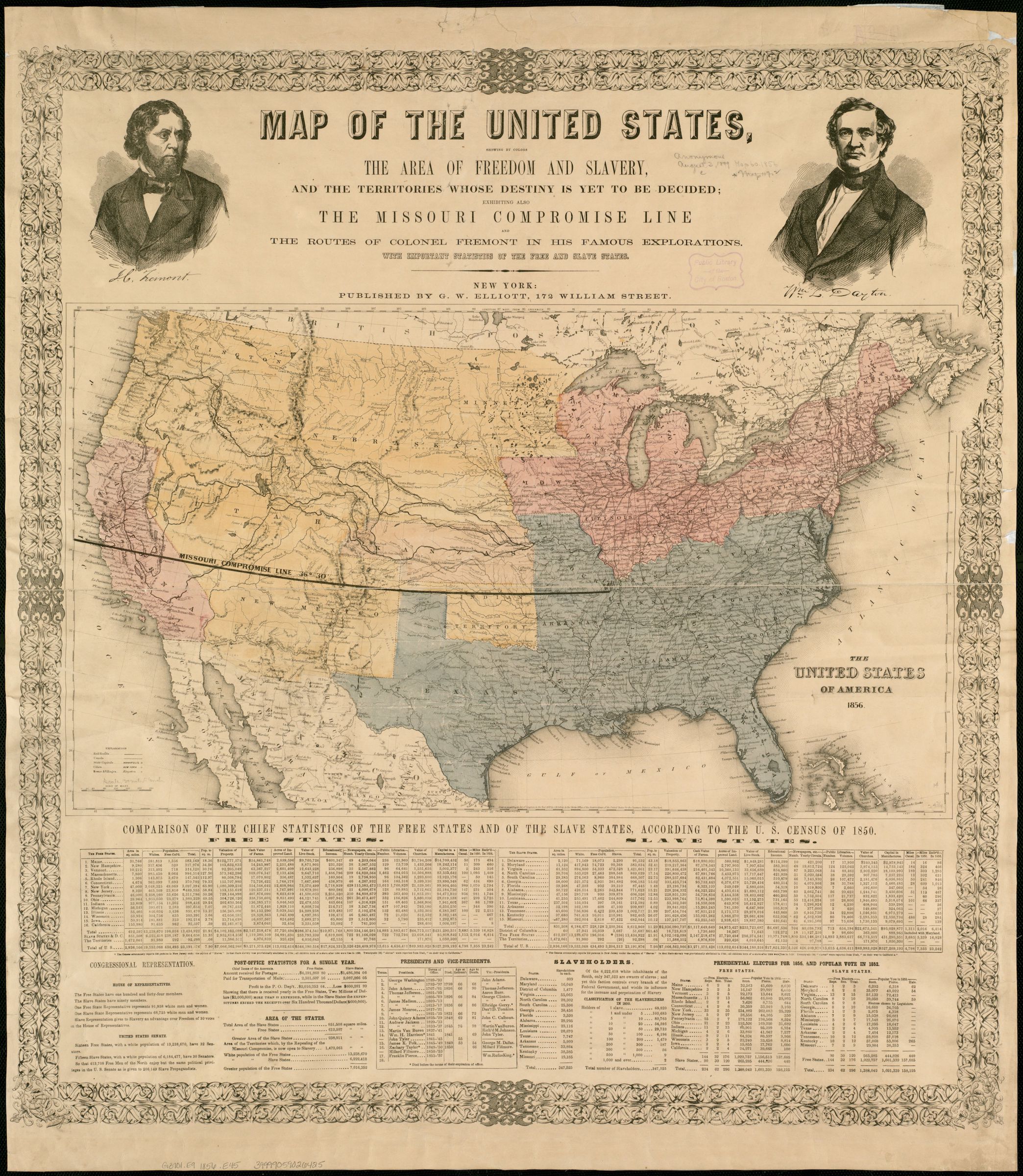
- 1 media/map of US showing free and slave states 1856_thumb.jpg 2021-04-01T15:39:46-07:00 Mark Guzdial 12293646cf3f9238a8ffe62e740f7f92aafe60a3 Map of the United States, showing by colors the area of freedom and slavery, and the territories whose destiny is yet to be decided : exhibiting also the Missouri compromise line, and the routes of Colonel Fremont in his famous explorations : with importa Mark Guzdial 2 Published as a campaign poster supporting the Republican Party's first presidential bid in 1856, this broadside provides a commentary on the geographical sectionalism that was polarizing the nation. Using 1850 census data, it tabulated the demographic and economic differences between free and slave states, highlighting political concerns that the balance of Congressional power would shift as newly acquired western territories were admitted as states into the Union. The map clearly marked the 1820 Missouri Compromise line, which had defined the boundary between free and slave states. However, the passage of the 1854 Kansas-Nebraska Act nullified this long-standing compromise line, and potentially opened the entire western territory to slavery because it sanctioned “popular sovereignty“ whereby citizens of each territory could vote on the slavery issue. plain 2021-04-01T15:40:15-07:00 Mark Guzdial 12293646cf3f9238a8ffe62e740f7f92aafe60a3
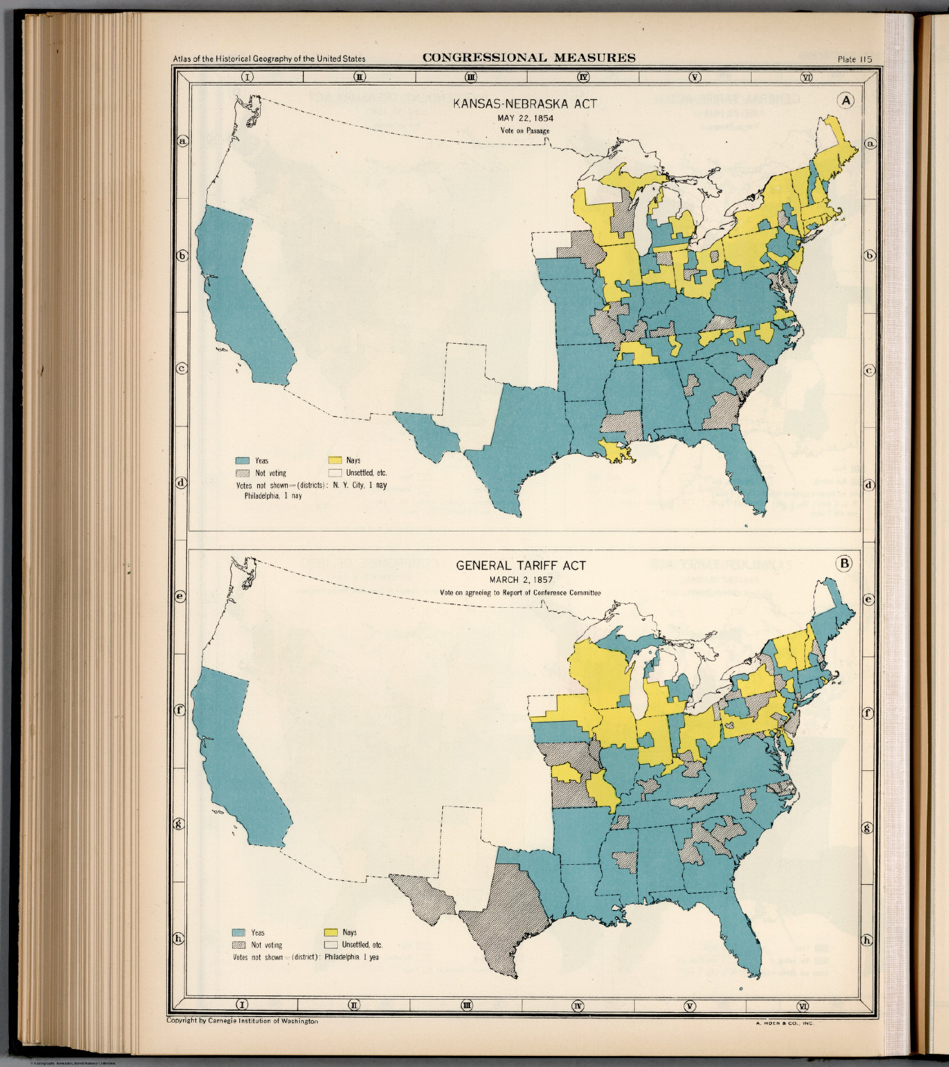
- 1 media/how states voted on the kansas nebraska act_thumb.jpg 2021-04-01T20:51:50-07:00 Anonymous Plate 115. Congressional Measures, 1854 - 1857 (1932) Mark Guzdial 2 Charles O. Paullin was a naval historian who is most known for his significant contribution to the early administrative history of the United States Navy. Paullin also has 1,459 maps in the Library of Congress. John Kirtland, also credited for this map, was an American geographer who was most known for his work in cartography, geosophy, and the study of the history of geographical thought. The map at the top of the image is a color-coded map of how various parts of the United States voted on the Kansas-Nebraska Act of 1854. plain 2021-04-01T20:54:03-07:00 Mark Guzdial 12293646cf3f9238a8ffe62e740f7f92aafe60a3
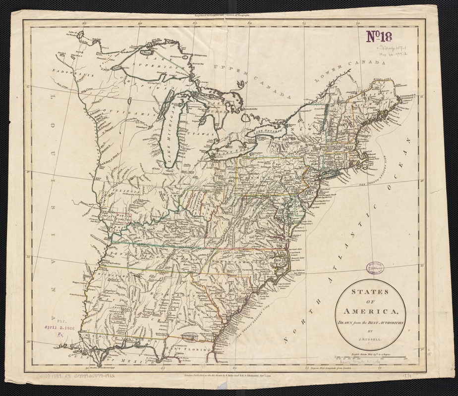
- 1 media/commonwealth_wd376442c_access800_thumb.jpg 2021-04-15T15:25:37-07:00 Mark Guzdial 12293646cf3f9238a8ffe62e740f7f92aafe60a3 States of America, drawn from the best authorities (1799) Mark Guzdial 1 The map shows states east of the Mississippi River along with various landforms such as rivers and mountain ranges in the area. plain 2021-04-15T15:25:37-07:00 Mark Guzdial 12293646cf3f9238a8ffe62e740f7f92aafe60a3
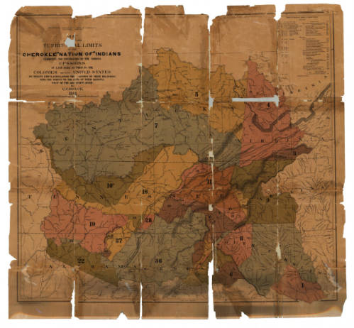
- 1 media/p15138coll23_175_medium_thumb.jpg 2021-04-15T15:54:09-07:00 Mark Guzdial 12293646cf3f9238a8ffe62e740f7f92aafe60a3 Map of the former territorial limits of the Cherokee "Nation of" Indians (1884) Mark Guzdial 1 This map shows the boundaries of the Cherokee Nation land and the cessions of land made to the colonies and the United States according to treaty stipulations. The map provides info that is color-coded dating from 1721 to the final removal of indigenous people in 1836. plain 2021-04-15T15:54:09-07:00 Mark Guzdial 12293646cf3f9238a8ffe62e740f7f92aafe60a3