Primary Source Data Visualizations for World History and Geography
1 media/Screenshot 2020-07-14 16.14.21.png media/Screen Shot 2020-06-30 at 8.07.00 PM.png 2020-05-01T05:25:08-07:00 Tamara Shreiner 72eaa2d1ba1352b75b8a8da73e879a4ceb510ae0 35133 92 This page provides a list of primary source data visualizations to support inquiry in world history and geography. They are organized according to the periodization scheme in Michigan's social studies standards for world history. plain 2021-08-16T12:58:07-07:00 1150 BCE Kristen Taurence 096bf11ea9ce4df55aba17c3029242306dd910c3Click HERE to see how these primary source data visualizations are connected to Michigan Social Studies Standards for Middle School World History & Geography.
Click HERE to see how these primary source data visualizations are connected to Michigan Social Studies Standards for High School World History & Geography.
Early Civilizations and Cultures and the Emergence of Pastoral Peoples, 4000 to 1000 BCE
Classical Traditions, World Religions, and Major Empires, 1000 BCE TO 300 CE
Expanding and Intensified Hemispheric Interactions, 300-1500 CE
The Emergence of the First Global Age, 15th to 18th Centuries
An Age of Global Revolutions, 18th Century-1914
Global Crisis and Achievement, 1900-Present Day
This page has paths:
- 1 2020-05-04T09:37:16-07:00 Tamara Shreiner 72eaa2d1ba1352b75b8a8da73e879a4ceb510ae0 Data Visualizations as Primary Sources Tamara Shreiner 70 Humans have been creating different types of data visualizations for centuries. Explore this collection of timelines, maps, graphs and charts to see what they reveal about the historical time and place in which they were produced. image_header 2023-08-23T07:00:26-07:00 Tamara Shreiner 72eaa2d1ba1352b75b8a8da73e879a4ceb510ae0
Contents of this path:
- 1 media/Screenshot 2020-07-14 16.14.21.png 2020-10-09T11:58:14-07:00 Tamara Shreiner 72eaa2d1ba1352b75b8a8da73e879a4ceb510ae0 Michigan K-12 Standards for Social Studies: Middle School World History & Geography 24 This page shows primary sources data visualizations that can be linked to the the Michigan Social Studies Standards for 7th-grade world history. To see data visualizations connected to a particular expectation, look for standard codes that are highlighted with a little icon next to them. If you click on the code, the page will shift to show you primary source data visualizations that are related to the expectation. plain 2021-04-14T07:58:25-07:00 Tamara Shreiner 72eaa2d1ba1352b75b8a8da73e879a4ceb510ae0
- 1 media/Screenshot 2020-07-14 16.14.21.png 2020-08-20T13:04:56-07:00 Tamara Shreiner 72eaa2d1ba1352b75b8a8da73e879a4ceb510ae0 Michigan K-12 Standards for Social Studies: High School World History and Geography 46 This page shows primary sources data visualizations that can be linked to the the Michigan Social Studies Standards for high school world history. To see data visualizations connected to a particular expectation, look for standard codes that are highlighted with a little icon next to them. If you click on the code, the page will shift to show you primary source data visualizations that are related to the expectation. plain 2021-08-16T13:05:04-07:00 Kristen Taurence 096bf11ea9ce4df55aba17c3029242306dd910c3
This page has tags:
- 1 2020-05-01T05:39:45-07:00 Tamara Shreiner 72eaa2d1ba1352b75b8a8da73e879a4ceb510ae0 Movement of the Planets Over Time (ca. 950) Tamara Shreiner 11 This anonymous graph, from De cursu per zodiacum, was for a time considered the first line graph in the history of data visualizations. Today we know it was copied in many medieval manuscripts. The graph shows an intermediate rectangular coordinate system for representing the path of the planets across the sky. The grid is made up of 360 squares. Shown on the vertical axis are the longitudes of the celestial sphere, specified as the 12 astrological signs, and on the horizontal axis the celestial latitudes are shown. plain 2020-07-15T15:43:34-07:00 48.448956, 1.507031 950 Tamara Shreiner 72eaa2d1ba1352b75b8a8da73e879a4ceb510ae0
- 1 2020-05-01T11:44:19-07:00 Tamara Shreiner 72eaa2d1ba1352b75b8a8da73e879a4ceb510ae0 Map of Cantino (1502) Tamara Shreiner 10 This manuscript map documents the politically powerful rivalries around new geographic discoveries. The Portuguese crown had supported seafaring for decades and required sailors to keep a logbook. Maps were created on this basis and were stored for safekeeping by the Portuguese marine bureau. The Italian envoy Alberto Cantino had this map copied secretly and smuggled it to Ferrara. It reflects the state of Portuguese knowledge around 1500--including the extensively mapped Brazilian coast, but also the fact that Brazil was thought to be its own landmass at the time. The map shows the struggle between European powers around the newly discovered regions--numerous sovereign flags along the coasts or on islands show the trading posts or regions laid claim to by different nations. plain 2020-07-20T09:35:56-07:00 38.733299, -9.137217 1502 Tamara Shreiner 72eaa2d1ba1352b75b8a8da73e879a4ceb510ae0
- 1 media/Screen Shot 2020-06-16 at 4.21.18 PM_thumb.png 2020-06-16T13:21:48-07:00 Carolyn Corey a3be5ecac5feb3465ab045c4d8c977721103c688 Bedolina Petroglyphs (1500 BCE) Tamara Shreiner 7 This image is a tracing of the Bedolina Petroglyphs in Italy. The first scientific survey of the rock in which this was carved was investigated in 1960, and the map was determined to be created around 1500-1400 BCE. The rock art was found in Valcamonica, Italy, and is assumed to be a depiction of nearby cultivated plots, mountain paths, and villages. UNESCO has recognized the petroglyphs as an important cultural heritage site. This tracing image can be found at http://www.rupestre.net/tracce/?p=2422 plain 2020-08-20T13:01:55-07:00 45.954894, 10.289384 1500 BCE Tamara Shreiner 72eaa2d1ba1352b75b8a8da73e879a4ceb510ae0
- 1 2020-05-01T11:56:34-07:00 Tamara Shreiner 72eaa2d1ba1352b75b8a8da73e879a4ceb510ae0 Universal Cosmography (1507) Carolyn Corey 7 This map is a key work in the development of scientific geography. There is only one surviving example of this woodcut, which is made up of 12 individual pages. The German cartographers Martin Waldseemüller and Matthias Ringmann decided to call the new (to Europeans, at least) continent in the west "America," after the first name of the seafarer Amerigo Vespucci. This unusual visualization came about because Waldseemüller extended Ptolemy's second projection (which was conceived for a smaller circumference of the Earth) in order to integrate the Pacific Ocean and North and South America. At the top, Ptolemy and Vespucci are pictured. plain 2020-07-21T18:48:49-07:00 48.285143, 6.947987 1507 Carolyn Corey a3be5ecac5feb3465ab045c4d8c977721103c688
- 1 2020-04-30T06:59:04-07:00 Tamara Shreiner 72eaa2d1ba1352b75b8a8da73e879a4ceb510ae0 D-day Normandy : the invasion and the first 48 days of action with the 743rd tank battalion in France (1945) Carolyn Corey 6 This map from April 1945 recounts the landing of the Allied troops at Normandy and their subsequent progress from the perspective of an American battalion. War-related theme notwithstanding, the design appears surprisingly cheerful--a fact that authors of the map in an unusual move, explicitly discuss in the accompanying text. plain 2020-07-31T07:32:45-07:00 38.888726, -77.004698 1945 Carolyn Corey a3be5ecac5feb3465ab045c4d8c977721103c688
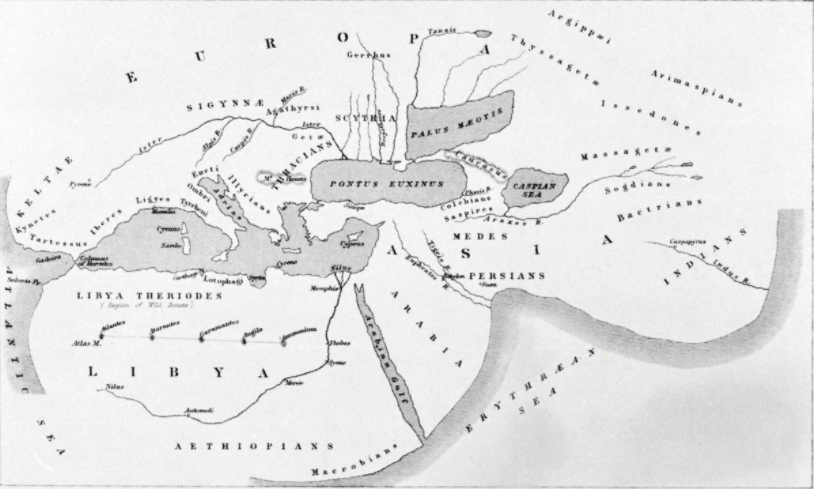
- 1 media/Screen Shot 2020-06-10 at 7.52.53 PM_thumb.png 2020-06-10T17:06:36-07:00 Carolyn Corey a3be5ecac5feb3465ab045c4d8c977721103c688 Map of the World (~500 BCE) Tamara Shreiner 6 Herodotus, creator of this map, was born ~484 BCE in the Persian Empire and was an ancient Greek author and historian. He is known as “The Father of History” as he wrote a first historical account of an event, being the Greco-Persian Wars. He created his map of the world, questioning that the world was flat. He improved the knowledge of the shape and extent of the regions of the world (that were known at that time) and made known that the Caspian Sea was an inland body of water, debunking its status as a “northern ocean.” plain 2020-07-15T15:23:40-07:00 37.040378, 27.421542 500 BCE Tamara Shreiner 72eaa2d1ba1352b75b8a8da73e879a4ceb510ae0
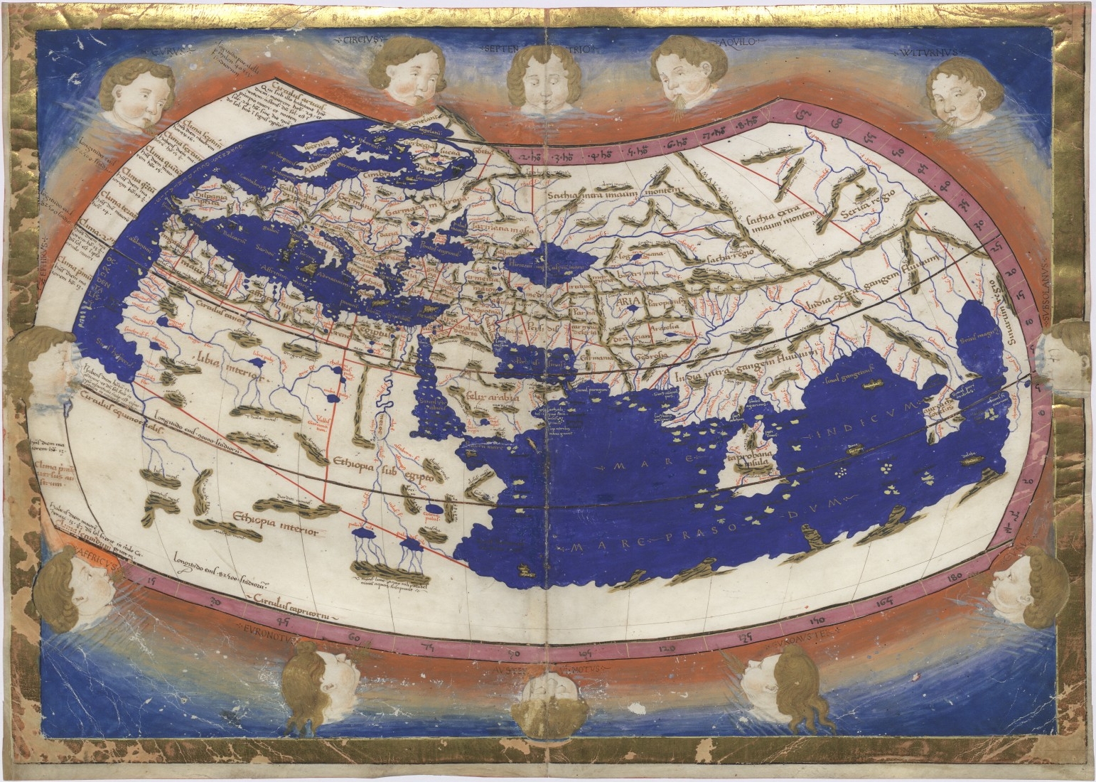
- 1 2020-05-01T06:02:06-07:00 Tamara Shreiner 72eaa2d1ba1352b75b8a8da73e879a4ceb510ae0 Ptolemy's Cosmographia (150 CE) Tamara Shreiner 6 With his Cosmographia, the Greek scholar Ptolemy left behind an authoritative work that shaped geographic knowledge in the Middle Ages and beyond. It includes written descriptions, instructions on map projections, and a comprehensive list of 8000 localities and their geographical coordinates. plain 2020-07-15T15:24:05-07:00 31.218750, 29.915736 150 Tamara Shreiner 72eaa2d1ba1352b75b8a8da73e879a4ceb510ae0
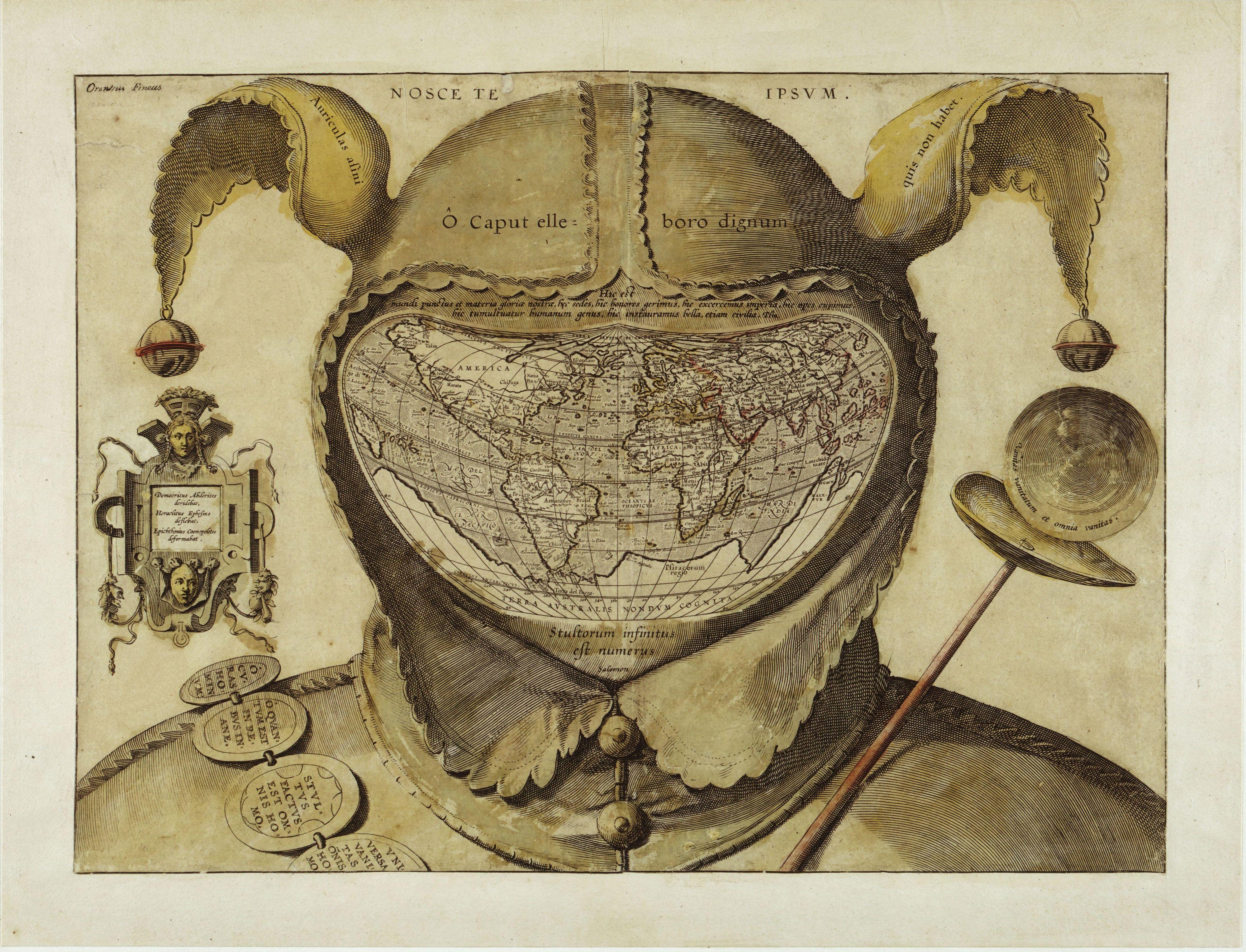
- 1 2020-04-30T07:28:46-07:00 Tamara Shreiner 72eaa2d1ba1352b75b8a8da73e879a4ceb510ae0 Fool's Cap Map of the World (1590) Carolyn Corey 6 This famous anonymous copperplate engraving mocks the scientific cartography boom of the 16th century and its close entanglement with power politics and geopolitical interests. A court jester is seen in his fool's cap, the opening of which frames a contemporary world map. The Latin inscriptions provide jocular oft-quoted words of wisdom. plain 2020-07-22T19:26:27-07:00 1590 Carolyn Corey a3be5ecac5feb3465ab045c4d8c977721103c688
- 1 2020-05-15T07:16:59-07:00 Tamara Shreiner 72eaa2d1ba1352b75b8a8da73e879a4ceb510ae0 Bird's Eye View of the Panama Canal (1915) Carolyn Corey 5 This English language map of the Panama Canal was published in 1915, one year after the completion of the project. A cross-section view of the elevation differences is linked with a detailed map of the stretches of land around the canal. The latter is oriented, against cartographic convention, toward the northeast in order to fit the length of the canal in horizontal format. The lower part contains an overview map of the isthmus and general information on Panama. Color-coded using two tones, the cross section depicts the successive stages of work on the canal: black indicates the first excavation work by the French Compagnie universelle du canal interoceanique de Panama. After they folded, the United States took over the project; their digging work is shown in red. plain 2020-07-31T07:30:33-07:00 8.967460, -79.564385 1915 Carolyn Corey a3be5ecac5feb3465ab045c4d8c977721103c688
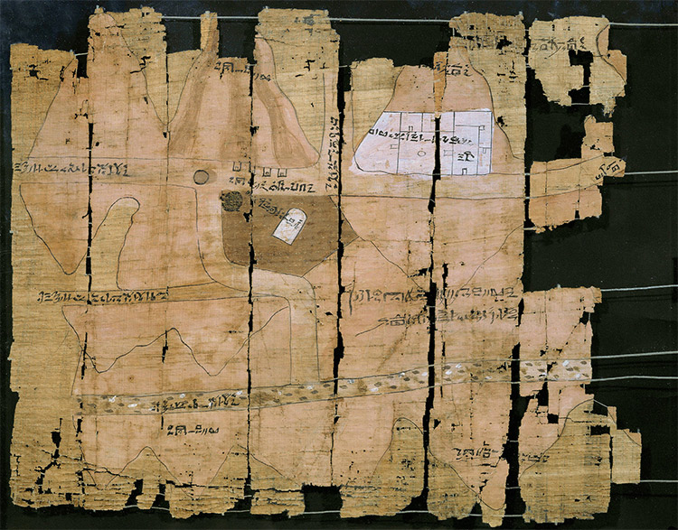
- 1 media/papyrus.jpg 2020-06-10T16:20:14-07:00 Carolyn Corey a3be5ecac5feb3465ab045c4d8c977721103c688 Turin Papyrus Map (1150 BCE) Tamara Shreiner 5 This map was discovered near ancient Thebes (now Luxor), between 1814-1821 by agents of Bernadino Drovetti, the French Consul General in Egypt. This is considered one of the oldest topographical, geological, and geographical map. Archaeologists and historians have determined that it was produced circa. 1150 BC by Scribe of the Tomb, Amennakhte. It is currently in the Turin Museum in northern Italy and was created to prepare for a quarrying expedition by Ramesses IV. It shows the ‘Valley of Many Baths’ with the source of the Nile at the top. The map shows locations of varying rock types as well as a quarry for bekhen stone, which was used to for statues of pharaohs and gods. This is known as the oldest surviving map in the world. plain 2020-07-15T15:22:53-07:00 25.721710, 32.608310 1150 BCE Tamara Shreiner 72eaa2d1ba1352b75b8a8da73e879a4ceb510ae0
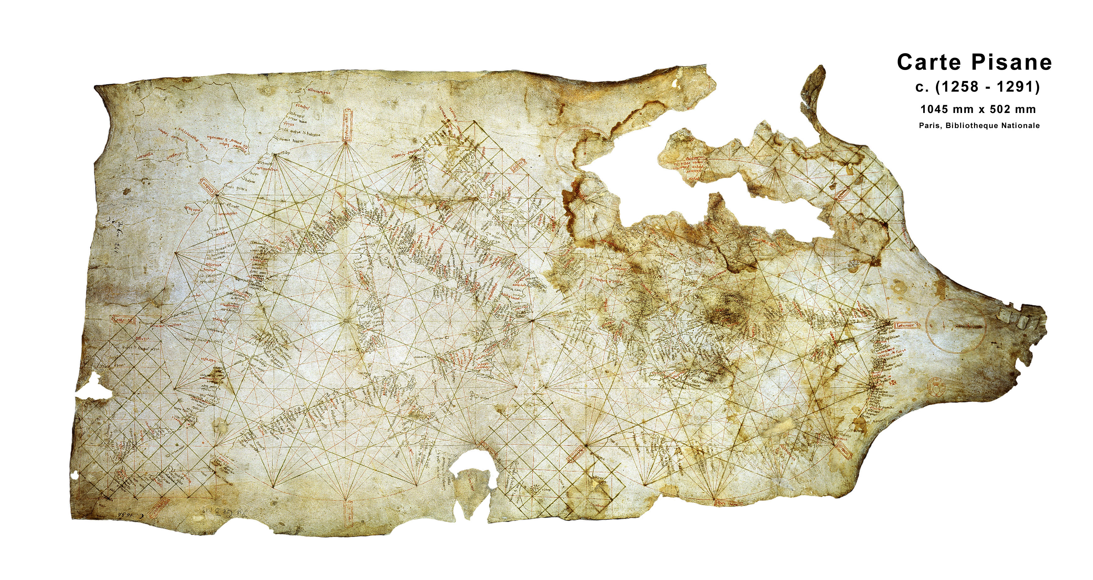
- 1 2020-06-30T07:16:53-07:00 Carolyn Corey a3be5ecac5feb3465ab045c4d8c977721103c688 Carte Pisane (1275-1300) Tamara Shreiner 5 The Carte Pisane (or Carta Pisana) is the oldest portolan chart (ancient nautical chart). It was probably of Italian origin, created in the second half of the 13th century. Evidence suggests that this chart was originally part of an atlas. Researchers have concluded that this map was not created by a professional clerk or scholar, based on the handwriting on the map. The map shows the entirety of the Mediterranean, the Black sea, and part of the coast of the Atlantic. Most of the accurate aspects of the map is limited to the Mediterranean. plain 2020-07-16T07:36:02-07:00 43.726948, 10.437983 1275-1300 Tamara Shreiner 72eaa2d1ba1352b75b8a8da73e879a4ceb510ae0
- 1 media/Screen Shot 2020-05-26 at 2.31.33 PM_thumb.png 2020-05-26T11:33:56-07:00 Carolyn Corey a3be5ecac5feb3465ab045c4d8c977721103c688 Portolan Atlas of the Mediterranean Sea, Western Europe, and the Northwest Coast of Africa (1590) Carolyn Corey 4 This map was created by Joan Oliva in 1590. Notice how America and Asia appear to be connected, and the sizes of the continents in the Northern Hemisphere compared to the Southern, plus a lack of Australia and Southern Asia. This data visualization can be found at https://www.loc.gov/resource/g3201pm.gct00065/?sp=5 plain 2020-07-22T19:27:39-07:00 38.270057, 15.548451 1590 Carolyn Corey a3be5ecac5feb3465ab045c4d8c977721103c688
- 1 media/12257000_thumb.jpg 2020-05-29T13:42:01-07:00 Carrie Finholm 6639ecc7d8d3786478af93b68ebed21d6d95960d World at War (1942) Carolyn Corey 4 Beginning in 1939, World War II was a global war that impacted and included the involvement of numerous countries on both the allied and axis powers. This map is a great representation that indicates where each country stood during the war. To the middle left, displays a legend to show neutrals, allied, and axis powers. It also shows which power occupied certain areas as of 1942. The creator of this map--Edwin L. Soundberg-- also incorporated on the bottom left the area each power obtained, the population, number of armies, air forces, and navies. On the bottom right includes dates of invasion and declaration of war. This image can be found at 40.641944, -73.978344 plain 2020-07-31T07:31:41-07:00 40.641944, -73.978344 1942 Carolyn Corey a3be5ecac5feb3465ab045c4d8c977721103c688
- 1 2020-06-16T13:42:38-07:00 Carolyn Corey a3be5ecac5feb3465ab045c4d8c977721103c688 Babylonian Map of the World (700-500 BCE) Tamara Shreiner 4 This was a unique map of the Mesopotamian world. Babylon is displayed in the center, while Assyria, Elam, and other places are named. While it may look like this map shows the correct positions of these places, this map is today used for an explanation for the ancient Babylonian view of the mythological world. This data visualization can be found at https://www.ancient.eu/image/526/babylonian-map-of-the-world/ plain 2020-07-15T15:23:17-07:00 32.507778, 44.426720 700-500 BCE Tamara Shreiner 72eaa2d1ba1352b75b8a8da73e879a4ceb510ae0
- 1 2020-05-04T11:23:55-07:00 Tamara Shreiner 72eaa2d1ba1352b75b8a8da73e879a4ceb510ae0 Van Langren's Map of the Moon (1645) Carolyn Corey 4 Like many of his contemporaries, Dutch geographer Michael Florent van Langren searched for a reliable method for determining longitude. He proposed measuring how long the mountains of the moon are illuminated before they slip into darkness during various lunar phases. This required an exact mapping of the Moon and a clear appellation of its craters. Thus this work was created, which in considered the first printed map of the Moon. The oceans on the moon, hypothesized by von Langren and his contemporaries, are shaded with dots, and mountains and craters are also mapped out. In a long process, van Langren assigned 322 names as orientation points--they are borrowed from European sovereigns, scholars, and saints. plain 2020-07-22T19:31:02-07:00 52.344942, 4.874722 1645 Carolyn Corey a3be5ecac5feb3465ab045c4d8c977721103c688
- 1 2020-05-08T06:27:56-07:00 Tamara Shreiner 72eaa2d1ba1352b75b8a8da73e879a4ceb510ae0 Statistical Chart Showing the Extent the Population & Revenues of the Principal Nations of Europe (1801) Carolyn Corey 4 William Playfair invented several types of diagrams to more clearly show abstract statistics. The second plate of The Statistical Breviary shows the current state of affairs in Europe in 1801. Circular diagrams represent different nations, with the size of the circle correlating to geographic extent. The lines to the left of each circle represent population and the lines to the right represent revenue. The line connecting them is problematic because it is affected by the circle's diameter. Naval powers are shown in blue and countries with armies are shown in red. The diagram for France shows its recent expansion due to a peace treaty. The fragmented position of Germany is notable. It is represented by the Habsburg Empire in Austria, various countries of the "German Empire," and Prussia. The diagram at the bottom of the page with overlapping circles illustrates opposing German interests. plain 2020-07-31T07:01:06-07:00 56.465039, -2.975766 1801 Carolyn Corey a3be5ecac5feb3465ab045c4d8c977721103c688
- 1 2020-05-04T13:51:49-07:00 Tamara Shreiner 72eaa2d1ba1352b75b8a8da73e879a4ceb510ae0 Chart Showing at One View the Price of the Quarter of Wheat, and Wages of Labour by the Week, from 1565 to 1821 (1821) Carolyn Corey 4 Created in 1821, this graph shows the price of wheat and weekly wages for a "good mechanic" under British rulers over about 300 years. The creator of this visual, William Playfair invented the line graph and bar chart. Here they are combined to represent a story over a long duration. plain 2020-07-31T07:07:39-07:00 56.465039, -2.975766 1821 Carolyn Corey a3be5ecac5feb3465ab045c4d8c977721103c688
- 1 2020-10-16T11:23:04-07:00 Tamara Shreiner 72eaa2d1ba1352b75b8a8da73e879a4ceb510ae0 Historical Map American Expeditionary Force (1932) Tamara Shreiner 4 plain 2020-10-16T11:36:16-07:00 40.437358, -79.983593 1932 Tamara Shreiner 72eaa2d1ba1352b75b8a8da73e879a4ceb510ae0
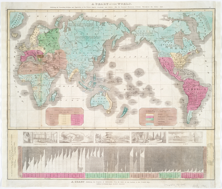
- 1 media/nypl.digitalcollections.510d47db-b010-a3d9-e040-e00a18064a99.001.w_thumb.jpg 2020-05-05T13:06:37-07:00 Tamara Shreiner 72eaa2d1ba1352b75b8a8da73e879a4ceb510ae0 A Chart of the World Exhibiting the Prevailing Religion and Population of the Present Empires, Kingdoms, and States (1842) Carolyn Corey 3 This thematic map shows the distribution of various religions across the world from a Western Christian perspective. Only the large monotheistic religions of Christianity, Islam, and Judaism are included, and only Christianity is further differentiated into Protestantism, Catholicism, and Orthodox Christianity. The continents are colored broadly according to prevailing religious alignment. Only Judaism lacks its own region due to the diaspora. Regions in which none of these religions predominate are marked as "pagan." The diagram in the lower part of the map includes a list of countries and a vertical timeline beginning with the birth of Christ. White stands for the extent of Christianity and a gray tone for that of Islam. This map can be viewed at https://digitalcollections.nypl.org/items/510d47db-b010-a3d9-e040-e00a18064a99. plain 2020-07-31T07:16:51-07:00 41.769283, -72.675485 1842 Carolyn Corey a3be5ecac5feb3465ab045c4d8c977721103c688
- 1 media/Carte_géologique_et_statistique_de_[...]Hommaire_de_btv1b53088046s_1_thumb.jpeg 2020-05-08T09:33:31-07:00 Tamara Shreiner 72eaa2d1ba1352b75b8a8da73e879a4ceb510ae0 Geological and Statistical Map of Southern Russia (1844) Carolyn Corey 3 From the end of the 18th century, the territory north of the Black Sea belonged consistently to the Russian Empire. By order of Russian general-governor Prince Vorontsov, the French engineer and geographer Xavier Hommaire de Hell undertook an extensive expedition through Crimea and the Caucasus to study the geological conditions and to locate raw materials. His map includes abundant and diverse information. In addition to classical topographical data on localities, bodies of water, infrastructure, and elevation, there is color-coded information on 19 different categories of soil characteristics of composition. Furthermore the map contains written information on individual regions (area, population, stationing of military units). This map can also be viewed at https://gallica.bnf.fr/ark:/12148/btv1b53088046s#. plain 2020-07-31T07:17:55-07:00 48.856967, 2.305853 1844 Carolyn Corey a3be5ecac5feb3465ab045c4d8c977721103c688
- 1 2020-06-01T08:03:13-07:00 Carolyn Corey a3be5ecac5feb3465ab045c4d8c977721103c688 Temple of Time (1846) Carolyn Corey 3 This timeline graphic, The Temple of Time, was created in 1846 by Emma Willard. This temple shows Universal Chronology. The description on the left bottom corner reads, “This Temple exhibits at one view the whole scheme of Universal Chronology, from the Creation to the present time. Each pillar represents the century corresponding to the number at its base. The pillars are in groups of tens, four groups before Christ, and two after, the last thousand years being deficient by a part of the nineteenth and the whole of the twentieth century. As pillars in building are begun at the bottom, so the time of the century represented by each pillar, is reckoned upwards. (See pillar for the eighteenth century.) The names of the pillars are of those sovereign by which the age is chiefly distinguished. The floor-work shows what have been the principal nations of the world, through the several centuries, which may be known by tracing to the bases of the pillars on each side. Of the principal nations of Europe, the names of all the sovereigns now reigning, and of those who have reigned since the discovery of America, are inserted; but antecedent to that period, only the names of the principal sovereigns are set down. The roof of the Temple contains, in five compartments, the names of the most celebrated persons of the age to which they belonged. The Temple in so far as the pillars and the roof are concerned, might be called the Temple of Time and of Fame. All the names inserted on those parts are of persons not now living.” This data visualization can be found at http://www.mappingthenation.com/blog/how-emma-willard-mapped-time-in-the-nineteenth-century/ plain 2020-07-31T07:19:54-07:00 42.712384, -73.664368 1846 Carolyn Corey a3be5ecac5feb3465ab045c4d8c977721103c688
- 1 media/11264002_thumb.jpg 2020-06-09T19:39:01-07:00 Carrie Finholm 6639ecc7d8d3786478af93b68ebed21d6d95960d Map of World Conquests: Victory Edition (1945) Carolyn Corey 3 This data visualization created in 1945 by Stanley Turner and C.C. Petersen is a collection of various maps that show domination and places that were conquered. The large map in the center presents events of WWII in the Eastern Hemisphere and conquered countries. Invasions, battles, and naval bases are included in the map. A legend is provided in the bottom center of the map. On the left sidelines includes conquerers of the past and their empires. Some of these include the Persian Empire, the Empire of Alexander the Great, the Roman Empire, the Conquests of Islam, Europe under Napoleon, and Asia under the Mongols. This image can be found at https://www.davidrumsey.com. plain 2020-07-31T07:35:00-07:00 40.637254, -73.928902 1945 Carolyn Corey a3be5ecac5feb3465ab045c4d8c977721103c688
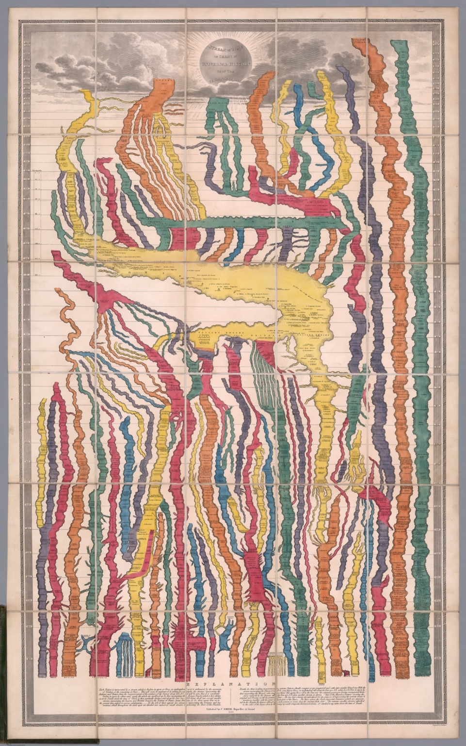
- 1 media/11194002_thumb.jpg 2020-05-08T06:37:37-07:00 Tamara Shreiner 72eaa2d1ba1352b75b8a8da73e879a4ceb510ae0 Stream of Time of the Chart of Universal History from the German of Strass (1803) Carolyn Corey 3 This wall chart created in 1803 is a novel combination of chronologic methods and influences from cartography. Its creator, the Prussian educator and historian Johann Gottlieb Friedrich Strass, was the head of pedagogical institutions and also taught history. In addition, he published history books for use in schools. The Stream of Time introduces a new visual metaphor: world history structured as the history of political entities--that is, kingdoms or nation states--with each being represented as a river. Territorial and political changes are indicated by a division of or a connection between individual rivers. A vertical timescale provides structure for these historical events. The visual can also be viewed at https://www.davidrumsey.com/luna/servlet/s/ar91g4. plain 2020-07-31T07:03:18-07:00 51.493266, -0.138707 1803 Carolyn Corey a3be5ecac5feb3465ab045c4d8c977721103c688
- 1 media/Chemin_de_fer_du_Nord_[...]_btv1b531363101_1_thumb.jpeg 2020-05-08T09:54:34-07:00 Tamara Shreiner 72eaa2d1ba1352b75b8a8da73e879a4ceb510ae0 Train Schedule of the French Northern Railroad (1852) Carolyn Corey 3 This type of train schedule in the form of a line graph was widely distributed in France in the late 19th century. The schedules, in which the vertical axis shows the route of the railway line and the horizontal hours of the day, offered an efficient visual tool to plan the traffic on a route and to publicize the schedule. This approach can be traced back to the French railway engineer Charles Ibry, who presented it to the French Minister of Public Works, according to a report in the Annales des ponts et chaussées in January 1847. He had previously introduced it to the French northern railway system where it was already in daily use for many years, per reports from this time. This image can be viewed at https://gallica.bnf.fr/ark:/12148/btv1b531363101/f1.item. plain 2020-07-31T07:21:00-07:00 48.822847, 2.340873 1852 Carolyn Corey a3be5ecac5feb3465ab045c4d8c977721103c688
- 1 2020-05-10T06:21:22-07:00 Tamara Shreiner 72eaa2d1ba1352b75b8a8da73e879a4ceb510ae0 Chart Showing the Progress of the Spasmodic Cholera (1832) Carolyn Corey 3 This is one of the first world charts of a disease. The map traces the spread of cholera from two main sources, India (1817) and China (1820), across Asia and the Middle East via trade routes, to France and England in 1832—and thence to North America. plain 2020-07-31T07:11:16-07:00 54.658468, -3.417390 1832 Carolyn Corey a3be5ecac5feb3465ab045c4d8c977721103c688
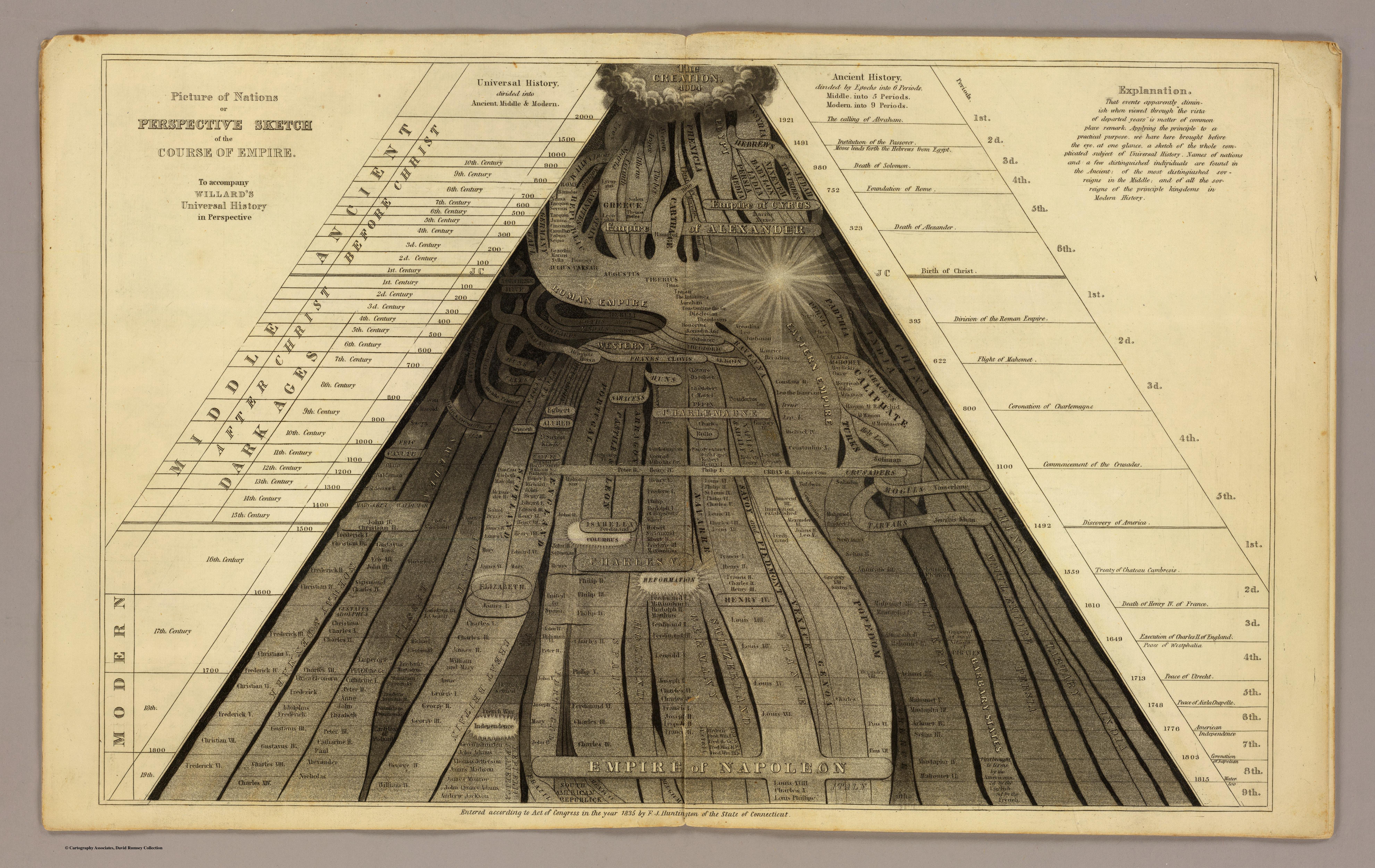
- 1 2020-06-01T07:08:29-07:00 Carolyn Corey a3be5ecac5feb3465ab045c4d8c977721103c688 Perspective Sketch of the Course of Empire (1836) Carolyn Corey 2 This chart of world history, created by Emma Willard in 1836, shows time as very fluid and flowing as a river. The birth of Christ is depicted by the bright light on the right side. The explanation in the top right corner reads, “That events apparently diminish when viewed through “the vista of departed years” is matter of common place remark. Applying the principle to a practical purpose, we have here brought before the eye, at one glance, a sketch of the whole complicated subject of Universal History. Names of nations and a few distinguished individuals are found in the Ancient; of the most distinguished sovereigns in the Middle; and of all the sovereigns of the principle kingdoms in Modern History.” This data visualization can be found at http://www.mappingthenation.com/blog/how-emma-willard-mapped-time-in-the-nineteenth-century/ plain 2020-07-31T07:15:36-07:00 41.768755, -72.676311 1836 Carolyn Corey a3be5ecac5feb3465ab045c4d8c977721103c688
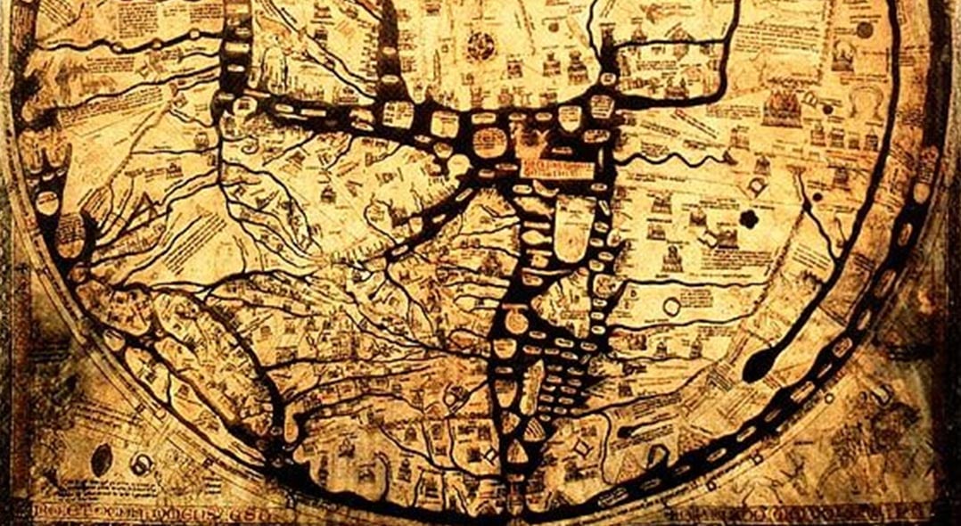
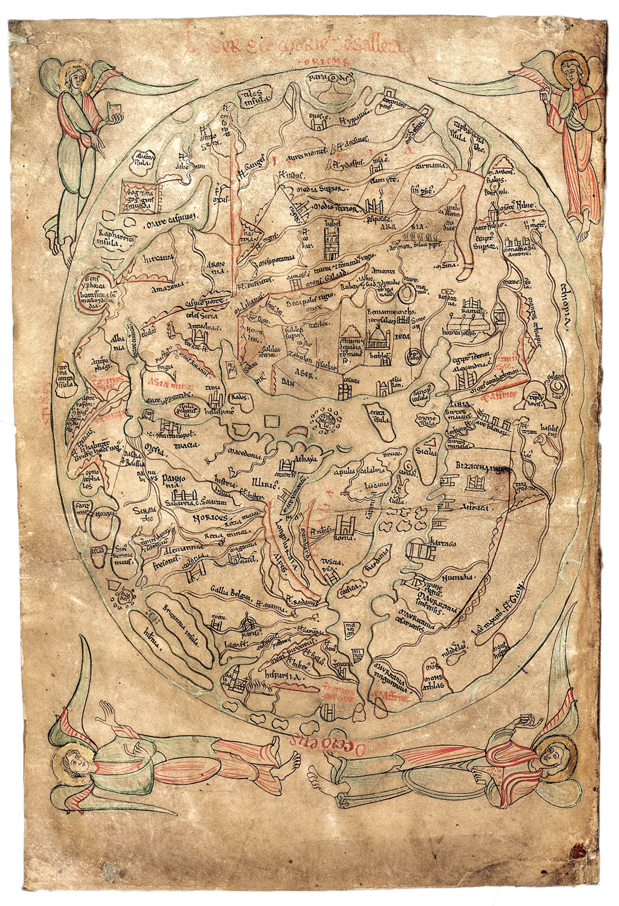
- 1 2020-06-30T07:48:44-07:00 Carolyn Corey a3be5ecac5feb3465ab045c4d8c977721103c688 Hereford Mappa Mundi (1300) Tamara Shreiner 2 There Hereford Mappa Mundi is a medieval map of the known world, dating from 1300. It is on display at Hereford Cathedral in England, and is the largest medieval map known to exist. It is 52 inches in diameter, depicting 420 towns, 15 Biblical events, 33 animals and plants, 32 people, and five scenes from classical mythology. Jerusalem sits at the center, while the Garden of Eden is a circle near the edge of the world. While flat-earth thinking was common during the Middle Ages, the spherical shape of earth was already known in ancient times, and thus the circular depiction of the earth in this visualization is probably an attempted spherical projection onto a flat surface. However, only the Northern Hemisphere was known to inhabit humans, so the circular representation was adequate for the time. Researchers believe that this map was created by multiple people, first by Richard de Bello (“Richard of Haldingham and Lafford”) and was passed onto a younger cousin. plain 2020-07-16T07:37:59-07:00 52.058968, -2.713679 1300 Tamara Shreiner 72eaa2d1ba1352b75b8a8da73e879a4ceb510ae0
- 1 media/Screen Shot 2020-06-30 at 11.20.04 AM_thumb.png 2020-06-30T08:21:15-07:00 Carolyn Corey a3be5ecac5feb3465ab045c4d8c977721103c688 Catalan Atlas (1375) Tamara Shreiner 2 The Catalan Atlas is a Medieval world map that was created in 1375. It is considered the most important map of the medieval world in the Catalan language. It was created by Cresques Abraham, a Jewish book illuminator who was described as a master of compasses. It is made up of six leaves, with the first two consisting of texts in Catalan that cover cosmology, astrology, and astronomy, accompanied by illustrations. The other four remaining leaves consist of the map itself, with Jerusalem close to the center. plain 2020-07-16T07:44:33-07:00 41.883323, 2.731931 1375 Tamara Shreiner 72eaa2d1ba1352b75b8a8da73e879a4ceb510ae0
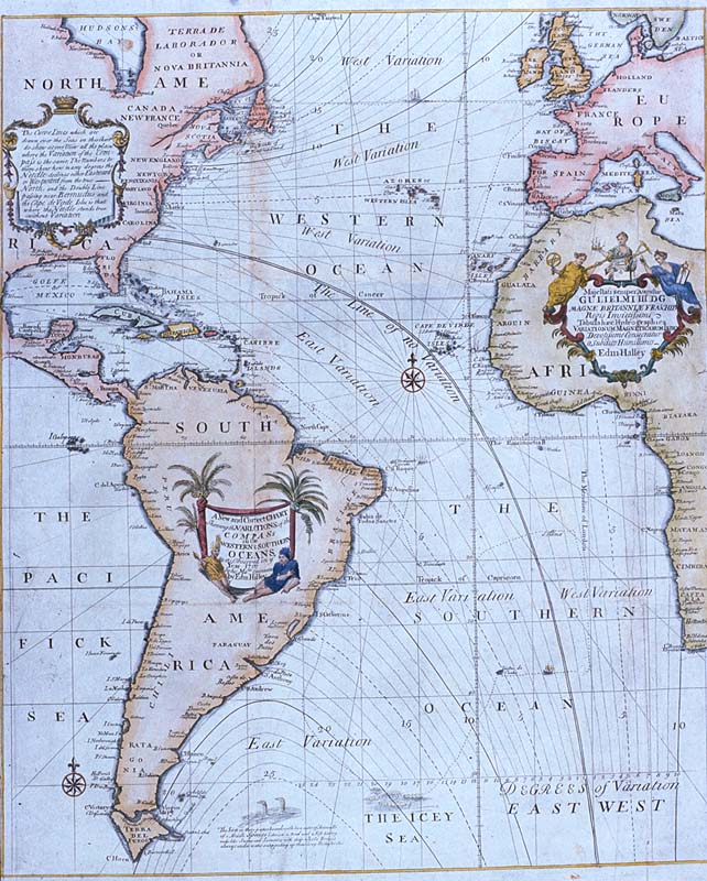
- 1 2020-05-04T13:34:30-07:00 Tamara Shreiner 72eaa2d1ba1352b75b8a8da73e879a4ceb510ae0 Halley's A New and Correct Chart (1701) Carolyn Corey 2 Edmond Halley was among the first to show how to map the invisible. This is the earliest map showing changes in magnetic declination of the compass (the angle on the horizontal plane between magnetic north and true north), crucially important to mariners at sea. To represent this data visually, he borrowed isometric lines from topography. plain 2020-07-22T19:34:32-07:00 53.467713, -2.724875 1701 Carolyn Corey a3be5ecac5feb3465ab045c4d8c977721103c688
- 1 media/11032000_thumb.jpg 2020-05-29T13:09:29-07:00 Carrie Finholm 6639ecc7d8d3786478af93b68ebed21d6d95960d Two-way Invasion Puts Germany in Tactical Dilemma (1945) Carolyn Corey 2 During World War II, Nazi Germany had been an leading power against many other countries in the world. In 1945, Nazi Germany had experienced a two-way invasion which put Germany in tactical dilemma to stay in power. The pictorial map shown, created in 1945 by Charles H. Owen, shows lines of attack, many major cities, roads, railroads, army bases, distances, mountain elevation, and relief. There are also historical notes and text within this colored map. This image can be found at https://www.davidrumsey.com/. plain 2020-07-31T07:33:46-07:00 34.107761, -118.303282 1945 Carolyn Corey a3be5ecac5feb3465ab045c4d8c977721103c688
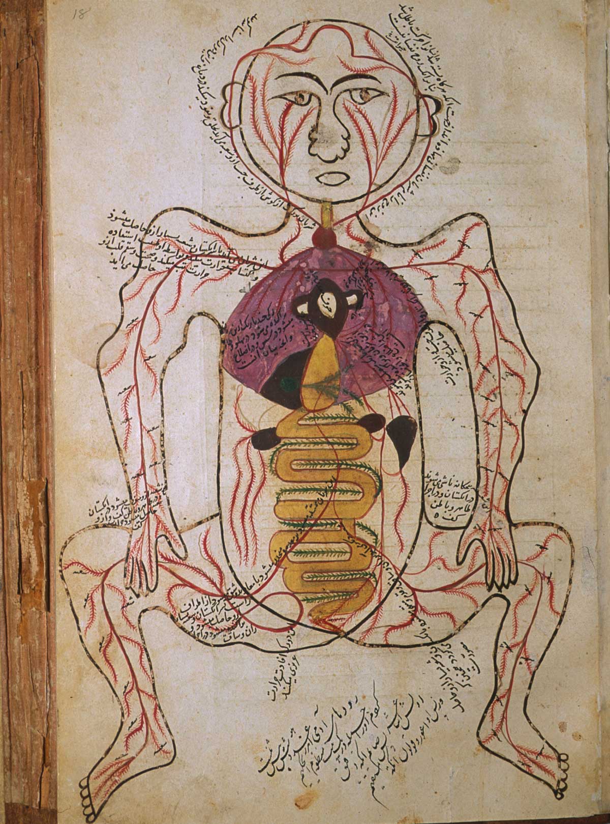
- 1 2020-05-07T16:13:06-07:00 Tamara Shreiner 72eaa2d1ba1352b75b8a8da73e879a4ceb510ae0 Mansur's Anatomical Illustrations (1390) Tamara Shreiner 2 For a long time anatomical knowledge was obtained indirectly, as many old cultures objected to cutting up corpses. The Persian author Mansur Ibn-Ilyas based his anatomy on the European-Latin teachings established by the Greek doctor Galen, which were in circulation in numerous medieval manuscripts. In particular the division of Mansur's work into five anatomical systems--bones, nerves, muscles, veins, arteries--as well as the schematic illustrations (here arteries with kidneys) that accompany the work reflect the remarkable continuity of anatomical knowledge across cultures. This particular anatomical illustration was thought to be created in 1390. plain 2020-07-16T07:46:40-07:00 29.622311, 52.491766 1390 Tamara Shreiner 72eaa2d1ba1352b75b8a8da73e879a4ceb510ae0
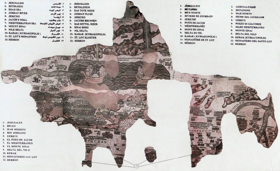
- 1 media/Screen Shot 2020-06-17 at 8.58.34 AM_thumb.png 2020-06-17T06:40:09-07:00 Carolyn Corey a3be5ecac5feb3465ab045c4d8c977721103c688 Madaba Mosaic Map (500) Tamara Shreiner 2 This map is from the second half of the 6th century and is considered to be one of the most important discovered artifacts from Western Asia and is one of the first pieces of evidence concerning ancient cartography. During construction of St. Georges Church in Madaba, Jordan, this map was discovered on the foundations of a Byzantine church. Only a quarter of the original mosaic was able to be preserved. The representation of Madaba was lost and was the most important part of the map which was directly in front of the pulpit of the Byzantine church, in line with Jerusalem. The original map displayed the area from Lebanon in the north to the Nile delta in the south, and from the Mediterranean Sea to the desert in the east. The Dead Sea and Jordan Valley form the central north-south axis. This mosaic was not necessarily used for traveling or typical map purposes, but was a complex work of Christian art with multiple layers of meaning. plain 2020-07-15T15:25:38-07:00 31.714876, 35.799258 500 Tamara Shreiner 72eaa2d1ba1352b75b8a8da73e879a4ceb510ae0
- 1 media/Screen Shot 2020-06-30 at 11.34.53 AM_thumb.png 2020-06-30T08:35:38-07:00 Carolyn Corey a3be5ecac5feb3465ab045c4d8c977721103c688 Kangnido World Map (1402) Tamara Shreiner 2 This is one of the oldest surviving world maps from East Asia and is important in understanding and reconstructing the original form of the 14th century Korean map. This map reflects the Korean and geographic knowledge of China during the Mongol Empire. Islamic geographers provided geographical information about Western countries. This map displays the form of the “Old World”, with Europe and Africa in the East and Japan in the east. There are currently two known copies of the map today, and are located in Japan containing modifications which were added later on. plain 2020-07-16T07:50:35-07:00 37.904830, 127.742408 1402 Tamara Shreiner 72eaa2d1ba1352b75b8a8da73e879a4ceb510ae0
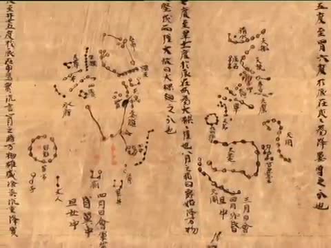
- 1 media/the-dunhuang-celestial-chart_360p_hd.original_thumb.jpg 2020-06-17T14:18:15-07:00 Carolyn Corey a3be5ecac5feb3465ab045c4d8c977721103c688 Dunhuang Star Chart (700) Tamara Shreiner 2 The Dunhuang Star Chart is one of the first known graphical chart of stars from ancient Chinese astronomers. This chart is dated back to the Tang Dynasty, 618-907. This scroll containing this chart was found in the Moago Caves in China. This chart shows over 1300 stars visible to the naked eye, before the telescope was invented. Celestial movements were incredibly important to Chinese culture and the actions of the emperor, and therefore the emperor hired many astronomers to make nightly recordings of the stars. These are valuable for astronomers today, as the sighting of a comet thousands of years ago can provide information for their locations today. plain 2020-07-15T15:27:08-07:00 40.041542, 94.809154 700 Tamara Shreiner 72eaa2d1ba1352b75b8a8da73e879a4ceb510ae0
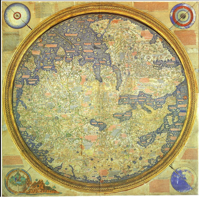
- 1 media/Screen Shot 2020-06-30 at 8.07.00 PM_thumb.png 2020-06-30T17:09:30-07:00 Carolyn Corey a3be5ecac5feb3465ab045c4d8c977721103c688 Fra Mauro Map (1450) Tamara Shreiner 2 This Fra Mauro map is a map of the world by Italian cartographer Fra Mauro. This map is considered to be the greatest memorial of medieval cartography. It is an incredibly detailed, major cartographical work. It is very large, measuring at over two by two meters, took several years to complete, and was very expensive. This map marks the end of Bible-based geography in Europe and the beginning of creating science-based maps. It was created for rulers of Venice and Portugal, the two seafaring superpowers of the time period. plain 2020-07-16T07:53:34-07:00 45.458369, 12.351379 1450 Tamara Shreiner 72eaa2d1ba1352b75b8a8da73e879a4ceb510ae0
- 1 2020-05-10T06:30:29-07:00 Tamara Shreiner 72eaa2d1ba1352b75b8a8da73e879a4ceb510ae0 New Cases of Cholera during the Epidemic of 1854 (1856) Carolyn Corey 2 Doctor Henry Acland published a comprehensive study on the cholera outbreak in Oxford in 1854. This treatise documents the intensive search for the sources of the terrible epidemic, the cause of which was unknown. It was often assumed that infection spread through bad air, which suggested weather-related influences. Thus Acland compared infection statistics with weather data, among other things in order to find causal relationships. This diagram combines the mortality rates during the epidemic with a series of meteorological data related to air pressure, ozone, wind, and humidity. Although he did not reach any clear conclusions, he hoped that future studies--if only they could be carried out fully enough--would shed light on the relationship between the epidemic and the weather. plain 2020-07-31T07:27:46-07:00 51.750821, -1.261323 1856 Carolyn Corey a3be5ecac5feb3465ab045c4d8c977721103c688
- 1 2020-06-29T06:48:44-07:00 Carolyn Corey a3be5ecac5feb3465ab045c4d8c977721103c688 The Sawley Map (1110) Tamara Shreiner 2 The Sawley world map was preserved in a late 12th century manuscript of De imagine mundi, a medieval encyclopedia, at Cambridge College in England. This map has 240 legends, with a large amount of unnamed cities, mountains, and rivers. There are around 225 geographical names, with cities and regions that are shown with an archeological symbol. Many of these symbols are significant in and allude to Christianity, with many symbols of significant Christian landmarks. The Sawley map has the Mediterranean Sea in the center, with Africa and the British Isles at its edges, and Paradise at the top. Biblical cities sit alongside contemporary places and characters and people from ancient legends are placed with current standing landmarks. plain 2020-07-15T15:40:27-07:00 53.913547, -2.341668 1110 Tamara Shreiner 72eaa2d1ba1352b75b8a8da73e879a4ceb510ae0
- 1 2020-05-15T07:08:35-07:00 Tamara Shreiner 72eaa2d1ba1352b75b8a8da73e879a4ceb510ae0 Kill that Eagle (1914) Carolyn Corey 2 The broader political situation in Europe in the year 1914 brought forth many humorous illustrated maps, of which this is perhaps the most well known. It was drawn by John Henry Amschewitz and published by the London map publishing house Geographia Ltd. The major and minor powers in Europe were symbolized by figures or animals that were supposed to demonstrate their "national character" as well as their stance in the run up to the world war. The German eagle swoops aggressively toward his neighbors, with France and Great Britain, in turn, confronting it with resolve. Austria-Hungary is ascribed a ridiculous role with the clown figure, Russia steps into the ring as a clumsy bear, while Italy seems to be singing an aria. The map also appeared in a pirated German edition--as a "document of Great Britain's treachery." plain 2020-07-31T07:29:01-07:00 51.494976, -0.118108 1914 Carolyn Corey a3be5ecac5feb3465ab045c4d8c977721103c688
- 1 2020-06-16T14:11:27-07:00 Carolyn Corey a3be5ecac5feb3465ab045c4d8c977721103c688 Peutinger Table (300-400 CE) Tamara Shreiner 2 Tabula Puetingeriana (Peutinger Table/Map) displays the Roman road network. The African continent is at the bottom, the European at the top, with Rome on the far left and the tip of Italy on the far right. The body of water is the Mediterranean Sea. Take note that this looks nothing like the Mediterranean region as seen from a birds-eye view, yet is still a good example of a practical map of linear Roman road routes. This map was created by Agrippa during the reign of Augustus (27-BCE – 14 CE). This data visualization can be found at https://landsat.gsfc.nasa.gov/geographia-from-antiquity-to-the-space-age/ plain 2020-07-15T15:22:04-07:00 40.664608, 15.106763 300-400 CE Tamara Shreiner 72eaa2d1ba1352b75b8a8da73e879a4ceb510ae0
- 1 2020-05-08T07:54:10-07:00 Tamara Shreiner 72eaa2d1ba1352b75b8a8da73e879a4ceb510ae0 Vimont Treatise on Human Phrenology (1832) Carolyn Corey 2 Not much is known about the French doctor Joseph Vimont except his impressive work on phrenology. The main thesis of this field of research, which today has long since been considered antiquated, was that intellectual abilities and individual personality traits are associated with specific areas of the brain. Through meticulous brain dissections, measurement of individual skulls, and the detailed mapping of the brain, researchers attempted to demonstrate these relationships. This visual shows the "skull of a fine conformation and of an adult man" and a sketch that illustrates "the seat of cerebral organs." plain 2020-07-31T07:13:51-07:00 48.856064, 2.32507 1832 Carolyn Corey a3be5ecac5feb3465ab045c4d8c977721103c688
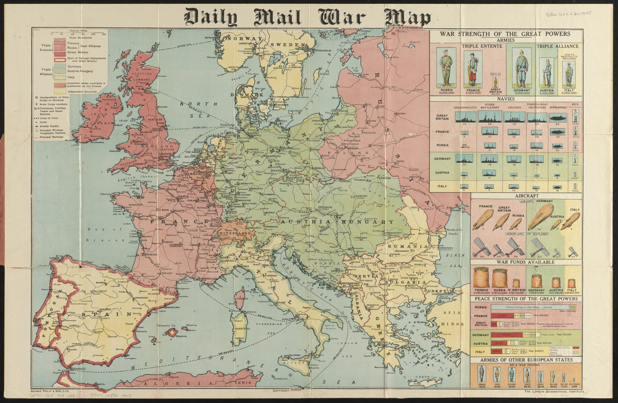
- 1 media/daily mail war map_thumb.jpg 2021-04-08T15:42:47-07:00 Mark Guzdial 12293646cf3f9238a8ffe62e740f7f92aafe60a3 Daily Mail War Map (1914) Mark Guzdial 1 The map depicts political boundaries, army troop numbers, army headquarters, forts, telegraph stations, and key railways. It also includes charts showing the strength of the Great Powers. plain 2021-04-08T15:42:47-07:00 51.5015310850933, -0.17512676628127805 1914 Mark Guzdial 12293646cf3f9238a8ffe62e740f7f92aafe60a3
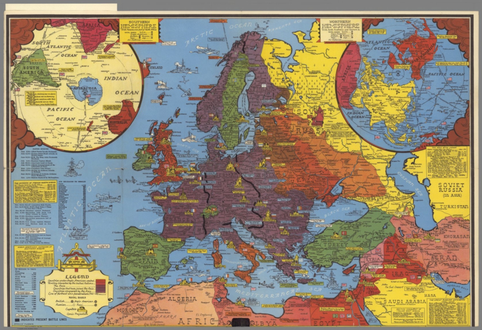
- 1 media/WWII by stanley turner_thumb.jpg 2021-04-09T18:40:23-07:00 Mark Guzdial 12293646cf3f9238a8ffe62e740f7f92aafe60a3 World War II map. by Stanley Turner (1943) Mark Guzdial 1 Stanley Turner was a British-born Canadian design artist and pictorial cartographer. The legend on the map shows naval bases and who controls what territory. plain 2021-04-09T18:40:23-07:00 45.51248782915382, -73.59025861773411 1943 Mark Guzdial 12293646cf3f9238a8ffe62e740f7f92aafe60a3
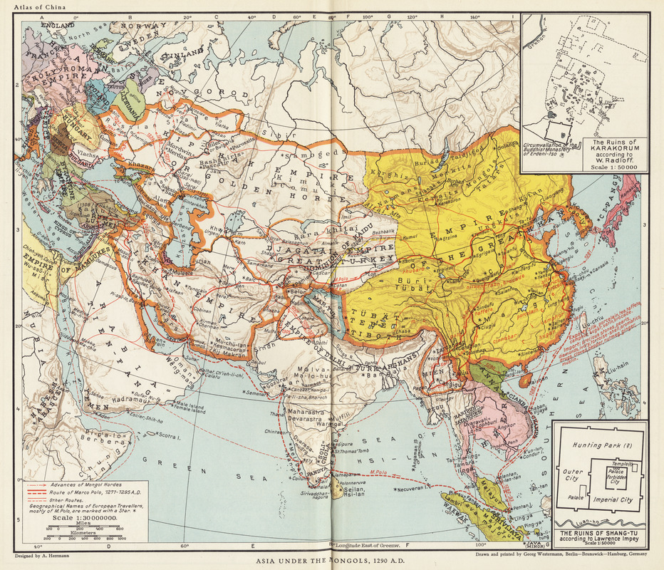
- 1 media/asia under the mongols 1290_thumb.jpg 2021-04-08T12:46:31-07:00 Mark Guzdial 12293646cf3f9238a8ffe62e740f7f92aafe60a3 Asia under the Mongols, 1290 A.D (1935) Mark Guzdial 1 Albert Herrman was a German geographer an archeaologist. Herrman had specialized knowledge of the ancient Mediterranean and Chinese geography. The map depicts Asia under the Mongols in the year 1290. plain 2021-04-08T12:46:31-07:00 53.54192509055724, 9.990963656623702 1935 Mark Guzdial 12293646cf3f9238a8ffe62e740f7f92aafe60a3
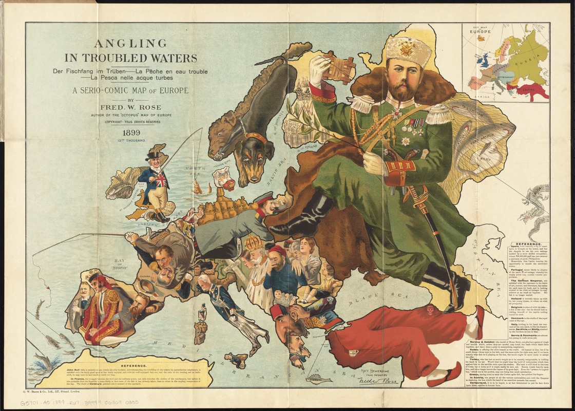
- 1 media/angling in troubled waters map_thumb.jpg 2021-04-08T15:19:29-07:00 Mark Guzdial 12293646cf3f9238a8ffe62e740f7f92aafe60a3 Angling in troubled waters: a serio-comic map of Europe (1899) Mark Guzdial 1 Frederick William rose is one of the most famous satirical mapmakers of his age. His maps often acted as political cartoons. This map, in particular, mocks European countries by depicting the leaders as a fisherman and the fish representing the nation's imperial pursuits. plain 2021-04-08T15:19:29-07:00 51.51167010851965, -0.11869427327680822 1899 Mark Guzdial 12293646cf3f9238a8ffe62e740f7f92aafe60a3