Thanks for your patience during our recent outage at scalar.usc.edu. While Scalar content is loading normally now, saving is still slow, and Scalar's 'additional metadata' features have been disabled, which may interfere with features like timelines and maps that depend on metadata. This also means that saving a page or media item will remove its additional metadata. If this occurs, you can use the 'All versions' link at the bottom of the page to restore the earlier version. We are continuing to troubleshoot, and will provide further updates as needed. Note that this only affects Scalar projects at scalar.usc.edu, and not those hosted elsewhere.
The Promise and Practice of Teaching Data Literacy in Social Studies: A Companion Site
Main Menu
A Taxonomy of Data Visualizations
Information can be visualized in multiple ways, from bar graphs to scatterplots, choropleth maps to distribution maps, timelines to time series. Designers can choose from an array of graphical elements such as points, lines, or icons used to represent data, and multiple aesthetic attributes such as color, shape, and size. Furthermore, designers can apply multiple combinations of titles, legends, and explanatory text to provide context for a data visualization. Given the almost dizzying array of data visualizations students may encounter in social studies, it is helpful to place them in categories related to the types of questions they will help us answer.
Data Visualizations as Primary Sources
Humans have been creating different types of data visualizations for centuries. Explore this collection of timelines, maps, graphs and charts to see what they reveal about the historical time and place in which they were produced.
How do students learn with data visualizations?
Reading data visualizations in print and online social studies texts can improve students' overall comprehension and quality of reasoning. And there is evidence to suggest that reading data visualizations helps students better understand historical and geographic context, multiple causation, and change over time — all important concepts for students to grasp in social studies subject areas. However, students may face significant challenges in trying to make sense of different kinds of data visualizations. This section provides insight into both benefits and challenges of reading timelines, maps, and graphs and charts.
How should students analyze data visualizations in social studies?
The challenges that data visualizations present, coupled with their prevalence in social studies texts, standardized assessments, in online social studies resources, and as sources of information in society, suggest that teaching with and about data visualizations in social studies is essential. This module provides guidance for how teachers can support students' data literacy for social studies.
How do I help students create and integrate data visualizations for social studies?
This page highlights several tools that are useful for data-based projects in social studies. And accompanying each tool is a "minimal manual" that provides guidance for using the tool in social studies inquiry- and project-based learning.
Project-Based Learning Activities for Data Literacy in Social Studies
Lorem ipsum dolor sit amet, nec constituto comprehensam te. Sea no affert nemore comprehensam, eum te purto soleat accusata. Ea est magna malis. No atqui iudico est. In vel propriae suavitate. Est homero timeam cu, novum persecuti mea an.
Index of Lesson Plans
This page contains a list of the minimal manuals and lessons found on this website. Minimal manuals are designed to be adapted to different grade levels and do not have a grade designation associated with them. Lesson plans are organized according to the school level for which they are designed. However, many of these lessons can be adapted for different grade levels.
Tamara Shreiner
72eaa2d1ba1352b75b8a8da73e879a4ceb510ae0
Primary Source Data Visualizations for Michigan History
1 media/Screenshot 2020-07-14 16.14.21.png 2020-05-19T04:54:03-07:00 Tamara Shreiner 72eaa2d1ba1352b75b8a8da73e879a4ceb510ae0 35133 34 This page provides a list of primary source data visualizations to support inquiry in Michigan history. They are organized according to the scope and sequence in Michigan's social studies standards, which has students studying Michigan before statehood in third grade, and after statehood in fourth grade. plain 2021-08-16T13:52:39-07:00 Kristen Taurence 096bf11ea9ce4df55aba17c3029242306dd910c3Click HERE to see how these primary source data visualizations are connected to Michigan Social Studies Standards for 3rd Grade Michigan History.
Click HERE to see how these primary source data visualizations are connected to Michigan Social Studies Standards for 4th Grade Michigan History.
Michigan Before Statehood
Michigan After Statehood
This page has paths:
- 1 2020-05-04T09:37:16-07:00 Tamara Shreiner 72eaa2d1ba1352b75b8a8da73e879a4ceb510ae0 Data Visualizations as Primary Sources Tamara Shreiner 70 Humans have been creating different types of data visualizations for centuries. Explore this collection of timelines, maps, graphs and charts to see what they reveal about the historical time and place in which they were produced. image_header 2023-08-23T07:00:26-07:00 Tamara Shreiner 72eaa2d1ba1352b75b8a8da73e879a4ceb510ae0
This page has tags:
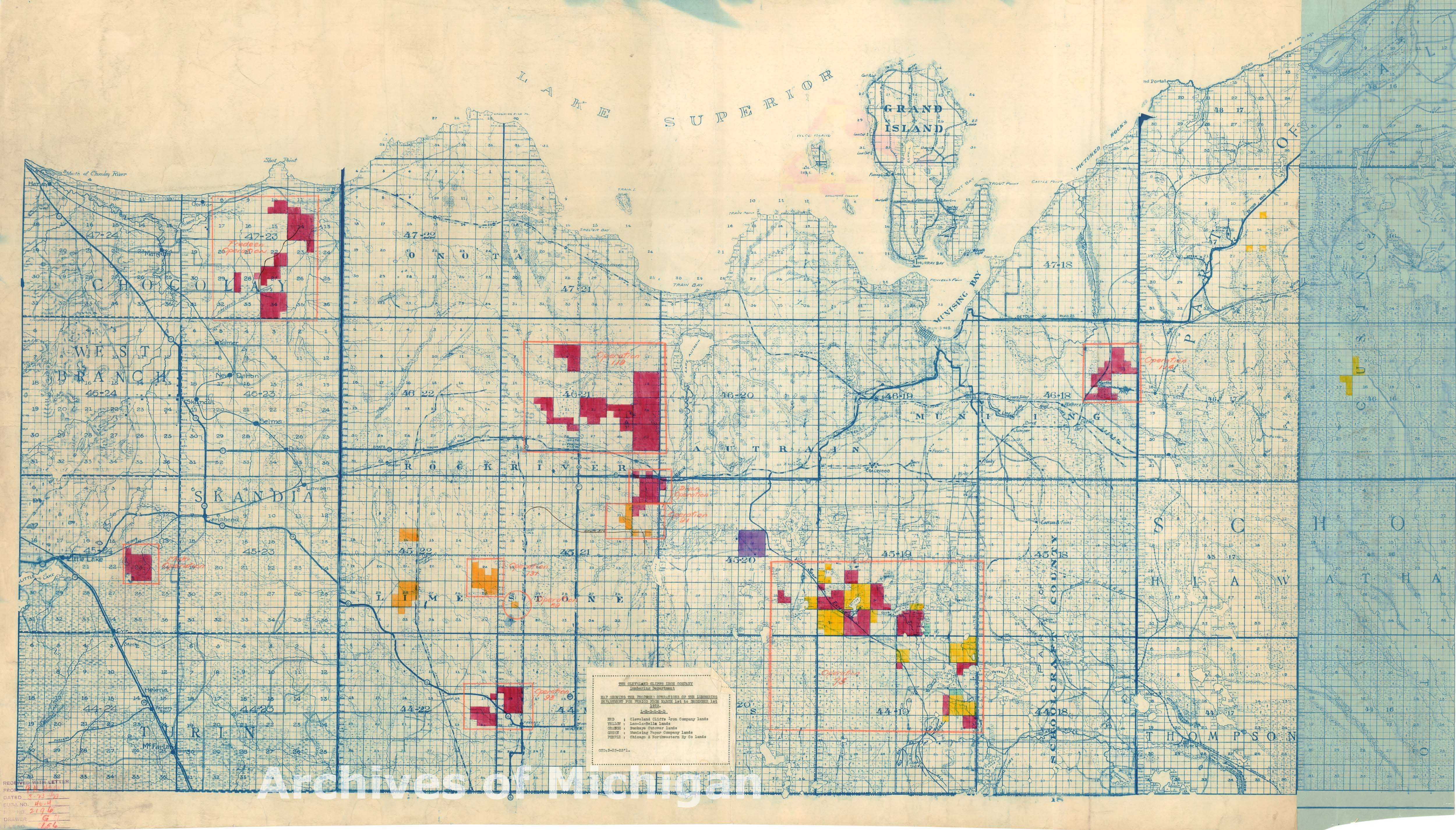
- 1 2020-07-28T10:58:07-07:00 Carrie Finholm 6639ecc7d8d3786478af93b68ebed21d6d95960d Lumbering Lands Owned by Mining Companies in the Upper Peninsula (1923) Carrie Finholm 13 The creator of this map is unknown, however it establishes and displays information regarding the lumbering lands owned by mining companies in the upper peninsula. The map also shows the proposed operations of the lumbering department for period from March 1st to December 1st in 1923. The different colors on the map show the different mining companies. A legend is provided at the bottom center to distinguish the different meanings of the colors. plain 2020-07-28T11:10:11-07:00 Carrie Finholm 6639ecc7d8d3786478af93b68ebed21d6d95960d
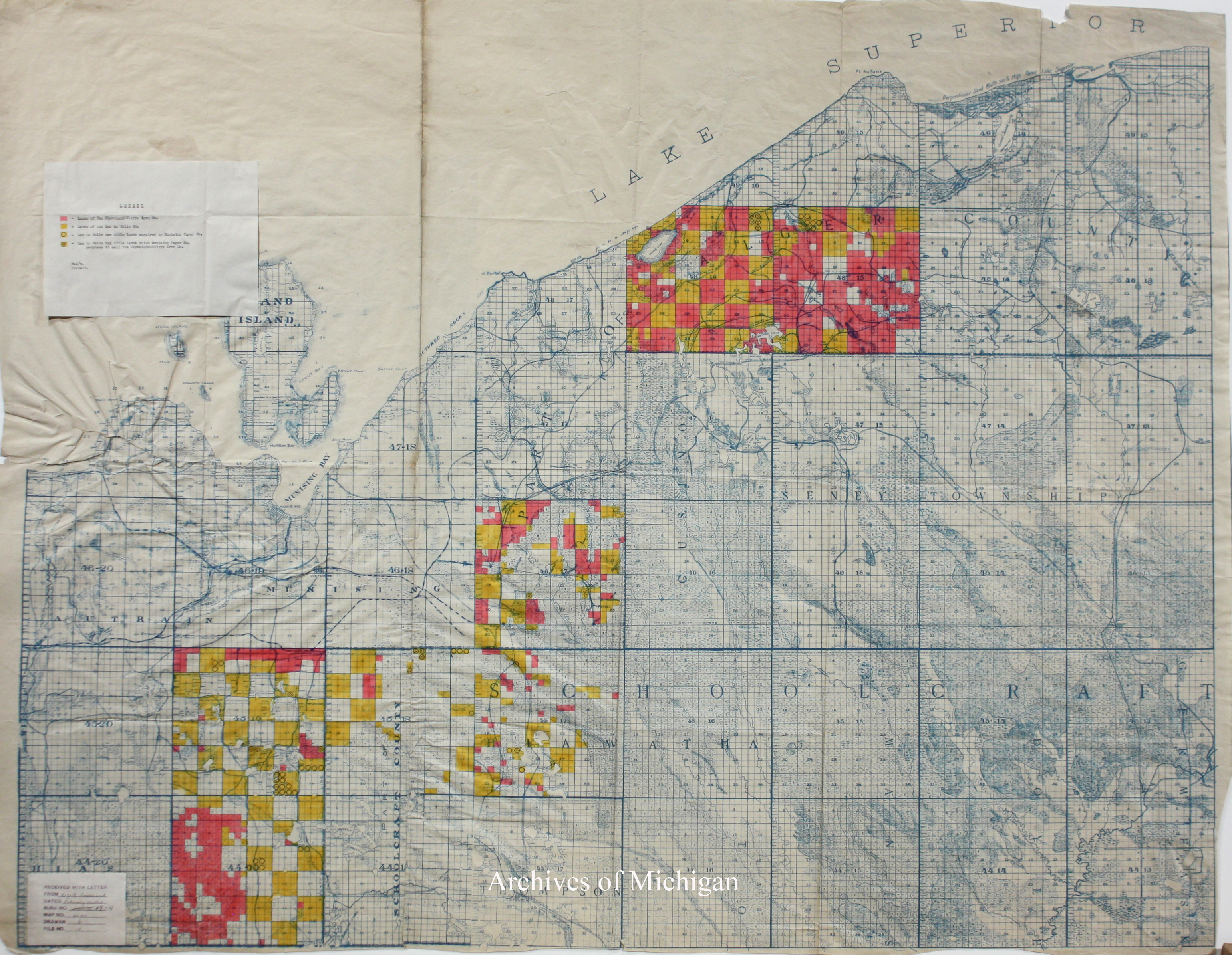
- 1 2020-07-28T11:17:34-07:00 Carrie Finholm 6639ecc7d8d3786478af93b68ebed21d6d95960d Land Owned by Mining Companies in the Mid-Upper Peninsula (1912) Carrie Finholm 11 The creator of this map is unknown but shows the land owned by mining companies in the mid-upper peninsula in the year of 1912. In the upper left hand corner, a legend is provided for the user to be able to determine the meaning behind the different colors and symbols on the map. plain 2020-07-28T11:22:59-07:00 Carrie Finholm 6639ecc7d8d3786478af93b68ebed21d6d95960d
- 1 2020-08-02T16:44:00-07:00 Carrie Finholm 6639ecc7d8d3786478af93b68ebed21d6d95960d Map Showing the Judicial Circuits and Congressional Districts of Michigan (1873) Carrie Finholm 9 Taken from the Atlas of the state of Michigan, this shows two maps created by Alexander Winchell and edited by H.F. Walling both from January 1st, 1873. One map displays the judicial circuits of Michigan and the other shows congressional districts of Michigan. plain 2020-08-02T16:55:03-07:00 Carrie Finholm 6639ecc7d8d3786478af93b68ebed21d6d95960d
- 1 2020-06-04T18:12:53-07:00 Carrie Finholm 6639ecc7d8d3786478af93b68ebed21d6d95960d Map of the Surface Formations of the Southern Peninsula of Michigan (1911) Carrie Finholm 9 Created by geologist Frank Leverett and in cooperation of Frank B. Taylor this map shows the surface formations of the southern peninsula of Michigan in the year of 1911. The bottom contains a legend that explains the color coordination of the different types of surfaces found in Michigan. plain 2020-07-20T15:09:16-07:00 Carrie Finholm 6639ecc7d8d3786478af93b68ebed21d6d95960d
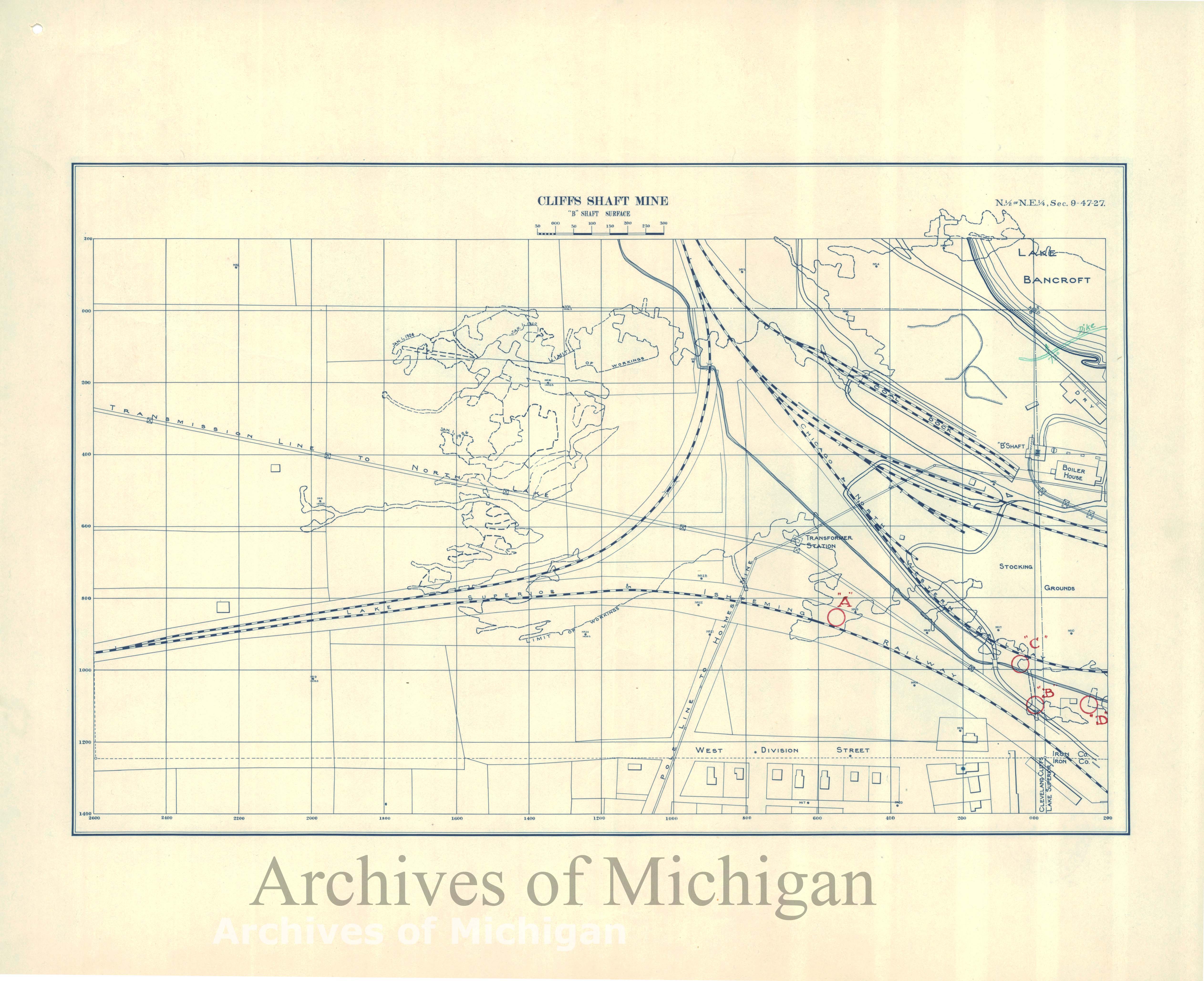
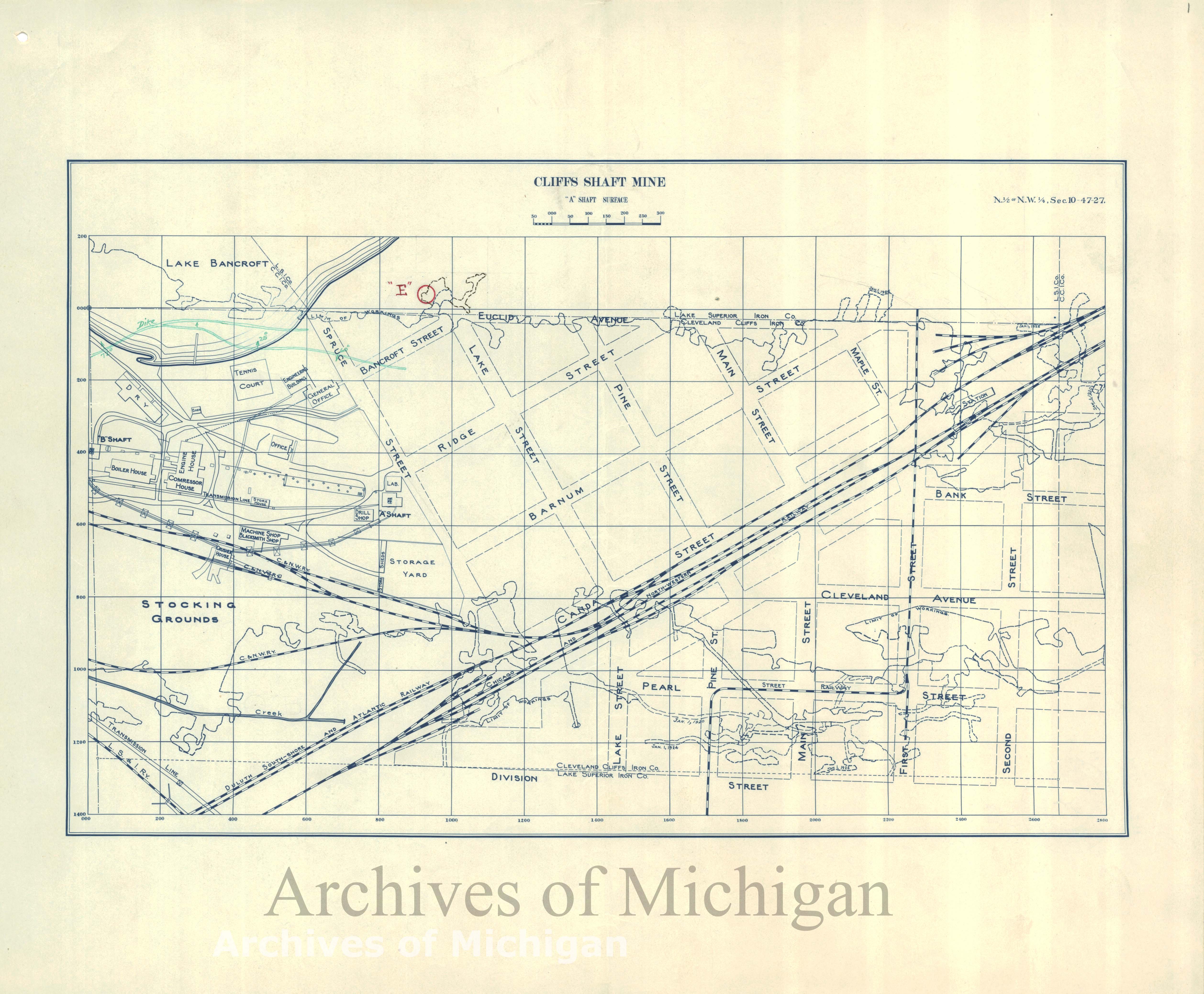
- 1 2020-07-28T11:34:09-07:00 Carrie Finholm 6639ecc7d8d3786478af93b68ebed21d6d95960d Profile of Cliffs-Shaft Mine Side 1 (1926) Carrie Finholm 6 The Cliffs Shaft Mine was a former iron mine that is now a heritage museum. The museum celebrates the history of the Marquette Iron Range. The mining company established 5 mining pits and different shafts A-E. This mine at one time was also the nation's largest producer of hematite. This map shows one side of the mining site as there is also another map on the Michigan History Primary Source page to show the second side. plain 2020-07-28T11:46:08-07:00 Carrie Finholm 6639ecc7d8d3786478af93b68ebed21d6d95960d
- 1 media/00074031_thumb.jpg 2020-05-24T14:41:32-07:00 Carrie Finholm 6639ecc7d8d3786478af93b68ebed21d6d95960d Map of Michigan Territory (1822) Carrie Finholm 5 Created in 1822 by H.C. Carey, this colored Altas Map displays the territory of Michigan before establishing statehood. This Altas is also the first American Altas to model Le Sage's plan of adding explanatory text on the sidelines of a map. Some of the explanatory text on the sidelines include the boundaries, face of the country (soil), lakes, bays, and rivers, animals, climate, civil divisions and population, towns and forts, commerce, government, and a historical sketch outline. The map in the center presents the general territory and rivers that they had charted at the time. This image can be found at https://www.davidrumsey.com/. plain 2020-07-20T13:14:28-07:00 Carrie Finholm 6639ecc7d8d3786478af93b68ebed21d6d95960d
- 1 2020-06-09T12:39:57-07:00 Carrie Finholm 6639ecc7d8d3786478af93b68ebed21d6d95960d Political Map of Michigan (1888) Carrie Finholm 5 Designed by Thomas Campbell-Copeland, this is a map that displays the political battle ground in the presidential elections from 1872-1888. The voting for each Michigan county is represented in colored bars for the years of 1872, 1876, 1880, 1884 and 1888. The bars that are blank were intended to be filled in after the 1888 election. The black bars resemble a majority vote for the Democratic Party and the red resembles a majority vote for the Republican Party for that year. For further explanation of colors, a key can be found on the upper right hand side of the map. The left sidelines of the map also give information on votes per county for Supreme Court Judges in 1887, votes for president in 1884, and the analysis for voting for president from 1872-1800. This image can be found at https://collections.leventhalmap.org. plain 2020-07-20T14:33:52-07:00 Carrie Finholm 6639ecc7d8d3786478af93b68ebed21d6d95960d
- 1 media/00064200_thumb.jpg 2020-06-13T14:15:56-07:00 Carrie Finholm 6639ecc7d8d3786478af93b68ebed21d6d95960d New Map of Michigan (1836) Carrie Finholm 5 One year before Michigan's statehood, this new map of Michigan-- created by Henry S. Turner --shows the different canals, roads & distances of Michigan. At the very top center of the map there is an explanation that goes over the various symbols provided on the map. The right sidelines of the map give steamboat routes of locations from Detroit to Fort Gratiot, Detroit to Fort Howard, and Detroit to Buffalo. This image can be found at https://www.davidrumsey.com/. plain 2020-07-20T13:37:07-07:00 Carrie Finholm 6639ecc7d8d3786478af93b68ebed21d6d95960d
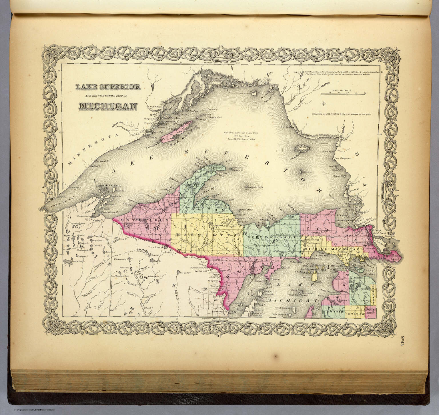
- 1 media/00134050_thumb.jpg 2020-05-24T15:27:22-07:00 Carrie Finholm 6639ecc7d8d3786478af93b68ebed21d6d95960d Map of Northern Part of Michigan and Lake Superior (1856) Carrie Finholm 4 G.W. Colton-- the creator of this Altas Map-- designed this map in color correlation of each county in Northern Michigan in the year of 1856. Lakes, rivers, important cities and locations are also included in this visual. This image can be found on https://www.davidrumsey.com/. plain 2020-07-20T14:02:05-07:00 Carrie Finholm 6639ecc7d8d3786478af93b68ebed21d6d95960d
- 1 2020-08-02T16:14:24-07:00 Carrie Finholm 6639ecc7d8d3786478af93b68ebed21d6d95960d Climatology of Michigan (1873) Carrie Finholm 4 Taken from the Altas of the State of Michigan from the University of Michigan Library, this map shows the climatology of Michigan estimated from the year of 1873. The Altas was created by Alexander Winchell and edited by H.F. Walling. The image show two different maps of Michigan's climatology. The first map demonstrates the seasons of January and July and the second map shows between summer and winter. plain 2020-08-02T16:23:01-07:00 Carrie Finholm 6639ecc7d8d3786478af93b68ebed21d6d95960d
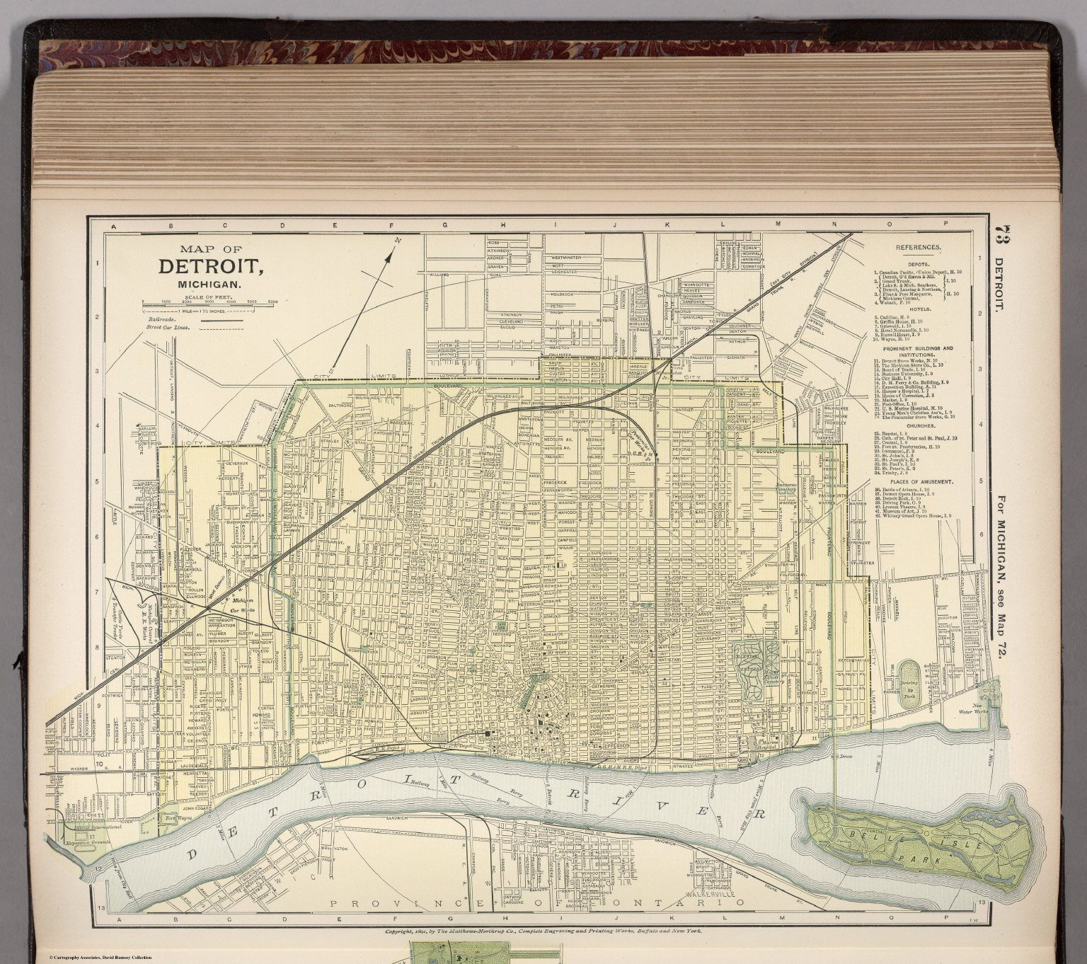
- 1 media/0026192_thumb.jpg 2020-05-24T13:28:02-07:00 Carrie Finholm 6639ecc7d8d3786478af93b68ebed21d6d95960d Map of Detroit, Michigan (1891) Carrie Finholm 4 This colored Altas Map of the city of Detroit, Michigan was created and published in 1891 by D. Appleton & Co, appromimately 54 years after Michigan was founded as a state. Railways, street car lines, blocks, parks, and canals are a few physical features shown. It also includes numerical references to deports, hotels, churches, important buildings, and many key points of interest. This image can be found at https://www.davidrumsey.com/. plain 2020-07-20T14:29:45-07:00 Carrie Finholm 6639ecc7d8d3786478af93b68ebed21d6d95960d
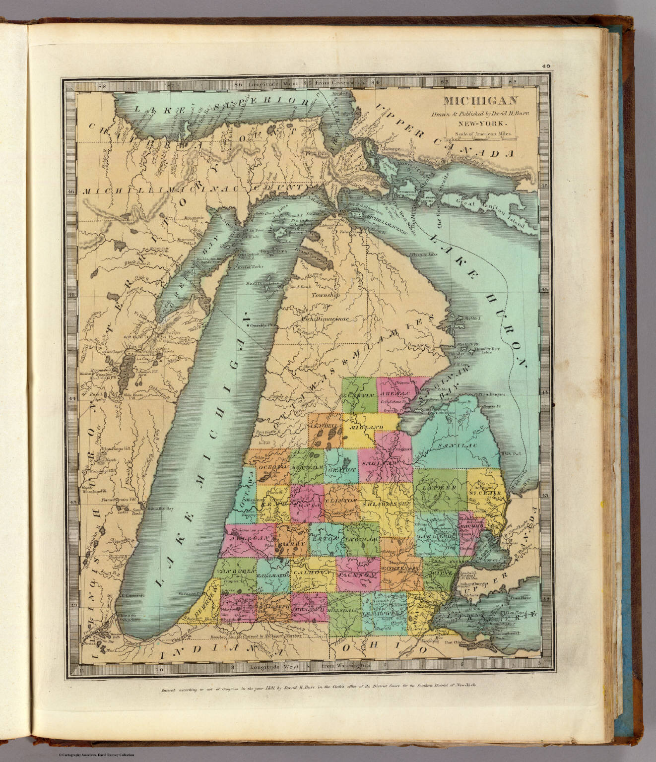
- 1 media/00404126_thumb.jpg 2020-06-13T14:36:02-07:00 Carrie Finholm 6639ecc7d8d3786478af93b68ebed21d6d95960d Michigan (1835) Carrie Finholm 4 With no date on the title page, this map was estimated with the copyright date between 1831-1835. This map of Michigan, which was before it became a state, was created by David H. Burr. It is in full color with territories and boundaries marked on the map. Important landmarks, such as rivers and lakes are also marked on the map, including counties. This image can be found at https://www.davidrumsey.com/. plain 2020-07-20T13:31:51-07:00 Carrie Finholm 6639ecc7d8d3786478af93b68ebed21d6d95960d
- 1 media/00224021.jpg 2020-05-24T14:05:51-07:00 Carrie Finholm 6639ecc7d8d3786478af93b68ebed21d6d95960d Map of Michigan (1838) Carrie Finholm 4 This colored Altas Map of Michigan is Thomas G. Bradford's best and first edition which was created in 1838, only about one year after statehood. Important cities, rivers, lakes, and counties are displayed upon the map that were established during the time. This image can be found at https://www.davidrumsey.com/. plain 2020-07-20T13:47:40-07:00 Carrie Finholm 6639ecc7d8d3786478af93b68ebed21d6d95960d
- 1 2020-07-28T12:03:48-07:00 Carrie Finholm 6639ecc7d8d3786478af93b68ebed21d6d95960d Plan of Princeton Mine No 2nd Shaft (1910) Carrie Finholm 4 The site first discovered in 1844, the Princeton Iron Mine was founded near Princeton, Michigan and has been a part of the Marquette Iron Mining District. This map displays the various types of minerals mined when the site was active. plain 2020-07-28T12:11:12-07:00 Carrie Finholm 6639ecc7d8d3786478af93b68ebed21d6d95960d
- 1 media/11122000_thumb.jpg 2020-05-29T15:54:05-07:00 Carrie Finholm 6639ecc7d8d3786478af93b68ebed21d6d95960d Greenfield Village: An Outdoor Museum (1951) Carrie Finholm 3 This pictorial map shows the world's largest indoor-outdoor history museum which was dedicated to Henry Ford. The museum is 13 acres and celebrates many accomplishments of American innovators. This particular map of the museum was created in 1951 and displays many buildings with index. The sidelines correlate where each building is located. There is also a compass rose in the center. This image can be found at https://www.davidrumsey.com/. plain 2020-07-20T14:52:48-07:00 Carrie Finholm 6639ecc7d8d3786478af93b68ebed21d6d95960d
- 1 2020-06-13T15:26:00-07:00 Carrie Finholm 6639ecc7d8d3786478af93b68ebed21d6d95960d Map of Grand Rapids, Michigan (1914) Carrie Finholm 3 This is a map from 1914 of the city of Grand Rapids, Michigan. The map shows how the city was organized at the time and where buildings were. The black squares near the top left corner of the map show the clustered buildings and architecture in the city. The red lines represent overall elevation in the area. This image can be found at USGS Science For a Changing World off of the Old Maps Online website. plain 2020-07-20T15:03:19-07:00 Carrie Finholm 6639ecc7d8d3786478af93b68ebed21d6d95960d
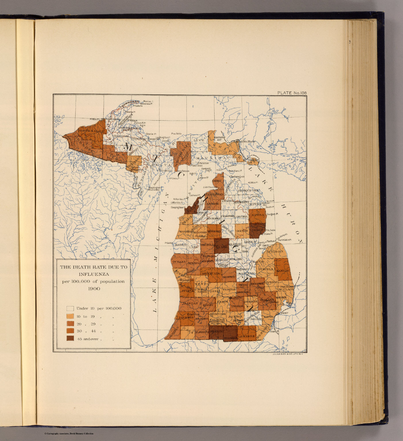
- 1 media/2152108_thumb.jpg 2020-06-13T14:07:18-07:00 Carrie Finholm 6639ecc7d8d3786478af93b68ebed21d6d95960d Influenza in Michigan (1903) Carrie Finholm 3 Published in 1903 from the United States Census Office (the twelfth census) and supervised by Henry Gannett, this map shows the distribution of the death rate of influenza per 100,000 of population in Michigan. The map is divided up by counties in the lower and upper peninsula of Michigan and displays areas where death rates were impacted; some higher and lower than others. The lower left hand corner shows a key to what the different colors represent. This image can be found at https://www.davidrumsey.com/. plain 2020-07-20T14:19:14-07:00 Carrie Finholm 6639ecc7d8d3786478af93b68ebed21d6d95960d
- 1 media/0889016_thumb.jpg 2020-06-23T14:44:57-07:00 Carrie Finholm 6639ecc7d8d3786478af93b68ebed21d6d95960d Domes & Basins; Geology of the Michigan Basin (1966) Carrie Finholm 3 This map of Michigan from 1966 shows the geology of the domes & basins within the state of Michigan. The left hand side of the map contains a description and gives more information about domes and basins. The authors James L. Scovel and Emmett J. O'Brien provided relief in the center of the map by adding contour and spot height. Depth of the map is shown by gradient hints. This image can be found at https://www.davidrumsey.com/. plain 2020-07-20T14:42:14-07:00 Carrie Finholm 6639ecc7d8d3786478af93b68ebed21d6d95960d
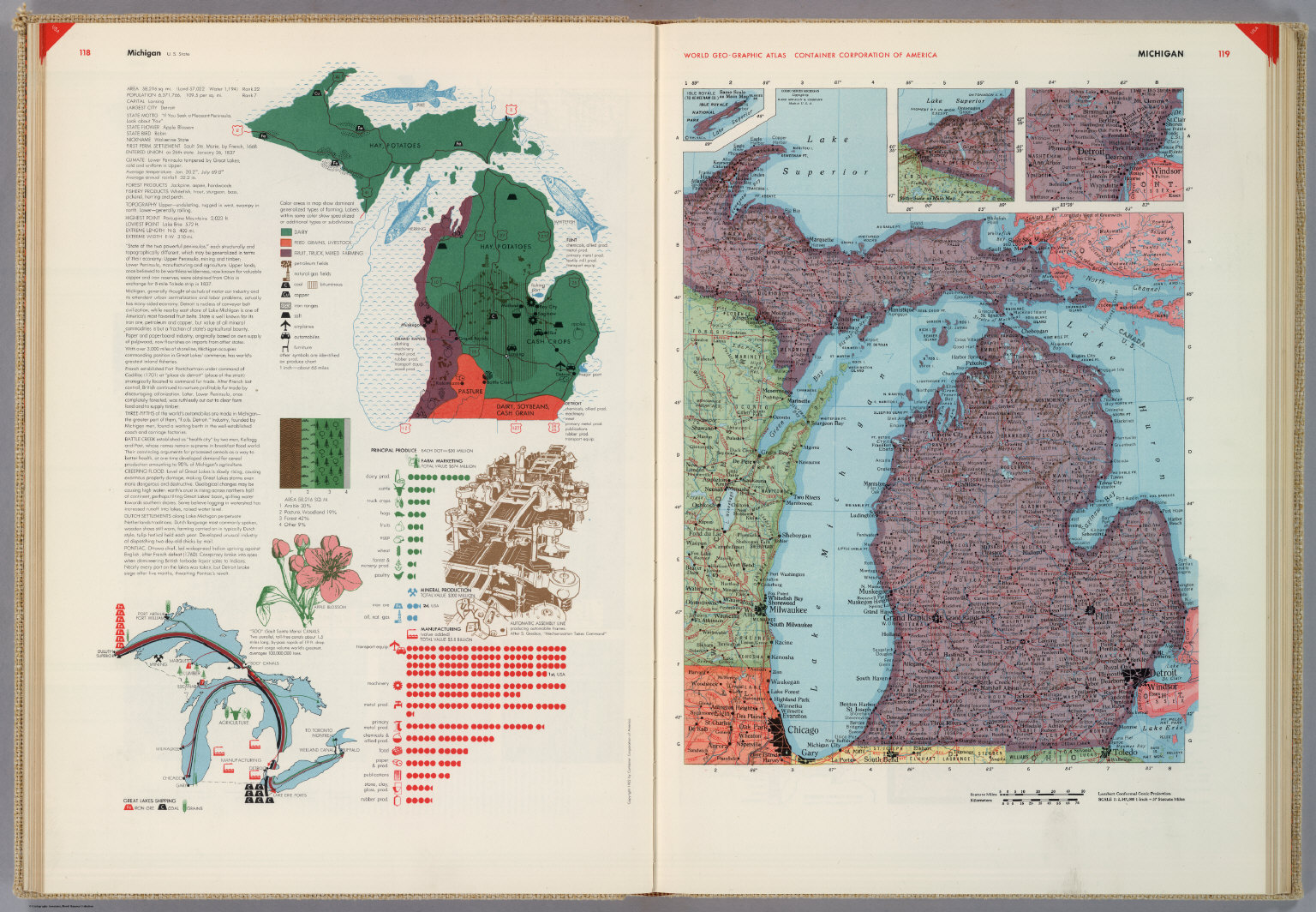
- 1 media/5842063_thumb.jpg 2020-06-23T14:25:43-07:00 Carrie Finholm 6639ecc7d8d3786478af93b68ebed21d6d95960d Michigan (1953) Carrie Finholm 3 This map of Michigan created in 1953 by Herbert Bayer and the Container Corporation of America shows many human characteristics and economic activity within the state. Some of these include principal resources, population, occupations, manufacturing, mineral production, agriculture, and land use. The left hand sideline contains a long description of important information that Michigan is known for. This image can be found at https://www.davidrumsey.com/. plain 2020-07-20T14:44:55-07:00 Carrie Finholm 6639ecc7d8d3786478af93b68ebed21d6d95960d
- 1 media/00134049_thumb.jpg 2020-05-24T15:13:53-07:00 Carrie Finholm 6639ecc7d8d3786478af93b68ebed21d6d95960d Map of Michigan (1856) Carrie Finholm 3 G.W. Colton-- the creator of this Altas Map-- designed this map in color correlation of each county in Michigan in the year of 1856. A key explanation is provided on the right hand side which includes rail roads, common roads, canals, state capital, country towns, townships, and villages. Rivers and lakes are also included in this visual. This image can be found at https://www.davidrumsey.com/. plain 2020-07-20T13:54:52-07:00 Carrie Finholm 6639ecc7d8d3786478af93b68ebed21d6d95960d
- 1 media/7823054_thumb.jpg 2020-05-29T18:35:00-07:00 Carrie Finholm 6639ecc7d8d3786478af93b68ebed21d6d95960d Pictorial Map of Michigan (1935) Carrie Finholm 3 This is a colorful and playful pictorial map of Michigan that was created in 1935 by Frank J. Taylor. The images displayed in the map reveal common things or events that the area was known for in a fun way. This image can be found at https://www.davidrumsey.com/. plain 2020-07-20T14:48:08-07:00 Carrie Finholm 6639ecc7d8d3786478af93b68ebed21d6d95960d
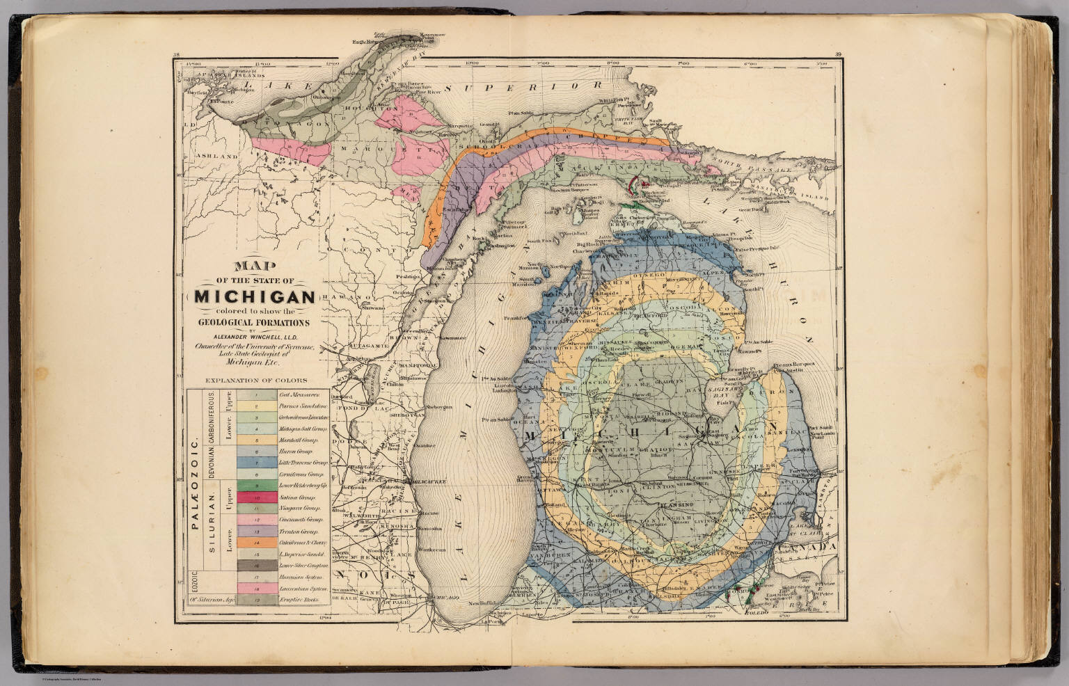
- 1 media/00734097_thumb.jpg 2020-06-29T09:15:16-07:00 Carrie Finholm 6639ecc7d8d3786478af93b68ebed21d6d95960d Map of the State of Michigan in Colors to Show Geological Formations (1873) Carrie Finholm 2 This map was created in 1873 by H.F. Walling and Alexander Winchell. Alexandar Winchell was a known as the Chancellor of the University of Syracuse and was a state geologist of Michigan at the time. This map shows the geological formations in the state of Michigan by using colors. Each color is represented on the left sideline of the map with a description of what it correlates with. The sideline also has different geological periods listed to go with each geological formation. This image can be found at https://www.davidrumsey.com/. plain 2020-07-20T14:09:46-07:00 Carrie Finholm 6639ecc7d8d3786478af93b68ebed21d6d95960d
- 1 2020-07-28T11:51:01-07:00 Carrie Finholm 6639ecc7d8d3786478af93b68ebed21d6d95960d Profile of Cliffs-Shaft Mine Side 2 (1926) Carrie Finholm 2 The Cliffs Shaft Mine was a former iron mine that is now a heritage museum. The museum celebrates the history of the Marquette Iron Range. The mining company established 5 mining pits and different shafts A-E. This mine at one time was also the nation's largest producer of hematite. This map shows one side of the mining site as there is also another map on the Michigan History Primary Source page to show the first side. plain 2020-07-28T11:54:16-07:00 Carrie Finholm 6639ecc7d8d3786478af93b68ebed21d6d95960d