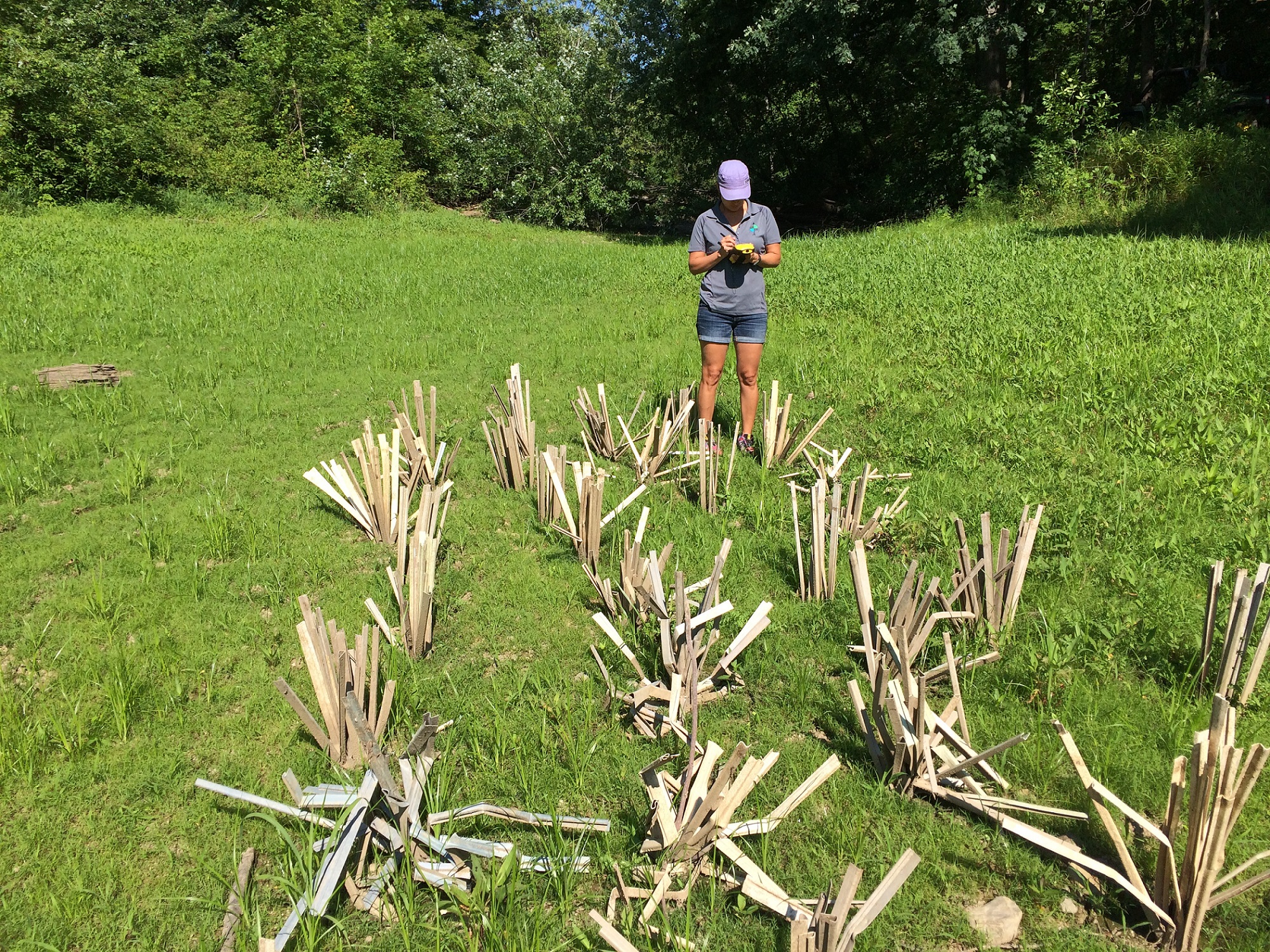
GIS Department Mapping of Habitat: Gerri Jimerson
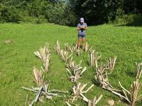
1 2018-07-26T18:00:21-07:00 Dana Reijerkerk 3c44fb85ab096c2290175e81dd4f16f0002a41e0 30861 5 The Nation's Geographic Information Services (GIS) Department works with Fish and Wildlife to map with GPS the areas where artifical habitat have been placed. Identified in the photograph is Gerri Jimerson, a member of the Nation's GIS Department. Gerri is standing in an area of the reservoir bottom where grass has begun to grow. plain 2018-08-20T16:19:07-07:00 Seneca Nation Fish & Wildlife Department 2018-07-18 stillimage FWD-005 independent sovereign nations, native peoples reservations Seneca-Iroquois National Museum eng The Nation's Geographic Information Services (GIS) Department works with Fish and Wildlife to map with GPS the areas where artifical habitat have been placed. Identified in the photograph is Gerri Jimerson, a member of the Nation's GIS Department. Gerri is standing in an area of the reservoir bottom where grass has begun to grow. 42.107313888889,-78.837822222222 electronic image/jpeg born digital Record has been transformed into MODS from the original accession record. Metadata originally created in a locally modified version of qualified Dublin Core. languageOfCataloging authority = "iso639-2b"; dcTerm:language recordCreation Date encoding = "w3cdtf"; dcTerm:date subject authority = "aat";dcTerm:subject subject authority = "tgn"; dcTerm:coverage dateCreated encoding= "w3cdtf"; dcTerm:temporal Allegany Reservation, Allegany (county), Allegany River Shane Titus This record was created by Dana Reijerkerk. 1 photograph 2016-08-08 Dana Reijerkerk 3c44fb85ab096c2290175e81dd4f16f0002a41e0Media
| resource | rdf:resource | https://scalar.usc.edu/works/ohiyo/media/fwd-005v5 |
| type | rdf:type | http://scalar.usc.edu/2012/01/scalar-ns#Media |
| is live | scalar:isLive | 1 |
| thumbnail | art:thumbnail | http://scalar.usc.edu/works/ohiyo/media/FWD-005v5_thumb.jpg |
| was attributed to | prov:wasAttributedTo | https://scalar.usc.edu/works/ohiyo/users/26037 |
| created | dcterms:created | 2018-07-26T18:00:21-07:00 |
Version 5
| resource | rdf:resource | https://scalar.usc.edu/works/ohiyo/media/fwd-005v5.5 |
| versionnumber | ov:versionnumber | 5 |
| title | dcterms:title | GIS Department Mapping of Habitat: Gerri Jimerson |
| description | dcterms:description | The Nation's Geographic Information Services (GIS) Department works with Fish and Wildlife to map with GPS the areas where artifical habitat have been placed. Identified in the photograph is Gerri Jimerson, a member of the Nation's GIS Department. Gerri is standing in an area of the reservoir bottom where grass has begun to grow. |
| url | art:url | media/FWD-005v5.jpg |
| default view | scalar:defaultView | plain |
| was attributed to | prov:wasAttributedTo | https://scalar.usc.edu/works/ohiyo/users/26037 |
| created | dcterms:created | 2018-08-20T16:19:07-07:00 |
| type | rdf:type | http://scalar.usc.edu/2012/01/scalar-ns#Version |
| source | dcterms:source | Seneca Nation Fish & Wildlife Department |
| date | dcterms:date | 2018-07-18 |
| type | dcterms:type | stillimage |
| identifier | dcterms:identifier | FWD-005 |
| subject | dcterms:subject | independent sovereign nations, native peoples reservations |
| contributor | dcterms:contributor | Seneca-Iroquois National Museum |
| language | dcterms:language | eng |
| abstract | dcterms:abstract | The Nation's Geographic Information Services (GIS) Department works with Fish and Wildlife to map with GPS the areas where artifical habitat have been placed. Identified in the photograph is Gerri Jimerson, a member of the Nation's GIS Department. Gerri is standing in an area of the reservoir bottom where grass has begun to grow. |
| spatial | dcterms:spatial | 42.107313888889,-78.837822222222 |
| format | dcterms:format | electronic |
| format | dcterms:format | image/jpeg |
| format | dcterms:format | born digital |
| conforms to | dcterms:conformsTo | Record has been transformed into MODS from the original accession record. Metadata originally created in a locally modified version of qualified Dublin Core. |
| conforms to | dcterms:conformsTo | languageOfCataloging authority = "iso639-2b"; dcTerm:language |
| conforms to | dcterms:conformsTo | recordCreation Date encoding = "w3cdtf"; dcTerm:date |
| conforms to | dcterms:conformsTo | subject authority = "aat";dcTerm:subject |
| conforms to | dcterms:conformsTo | subject authority = "tgn"; dcTerm:coverage |
| conforms to | dcterms:conformsTo | dateCreated encoding= "w3cdtf"; dcTerm:temporal |
| coverage | dcterms:coverage | Allegany Reservation, Allegany (county), Allegany River |
| creator | dcterms:creator | Shane Titus |
| creator | dcterms:creator | This record was created by Dana Reijerkerk. |
| extent | dcterms:extent | 1 photograph |
| temporal | dcterms:temporal | 2016-08-08 |
This page is referenced by:
-
1
2018-07-25T22:05:23-07:00
Ohi:yo' Restoration and Resiliency Projects
20
Members of the Seneca Nation's Watershed Resources Working Group are involved in various restoration and resiliency projects for our Ohi:yo'. The Seneca Nation's Fish and Wildlife Department in particular engages in projects related to building artificial habitat, repopulating our river's Walleye population, and building trenches to help land locked fish.
plain
788140
2018-08-27T01:23:30-07:00
Members of the Seneca Nation's Watershed Resources Working Group are involved in various restoration and resiliency projects for our Ohi:yo'. The Seneca Nation's Fish and Wildlife Department in particular engages in projects related to building artificial habitat, repopulating our river's Walleye population, and building trenches to help land locked fish. The restoration and resiliency projects were made possible by a U.S. Department of the Interior Hurricane Sandy Grant, which was awarded through the National Fish and Wildlife Foundation.
Artificial Habitat
The seasonal lowering and emptying of the water reserves within the reservoir leave our inundated land exposed and unprotected to weather elements for part of the year. This annual exposure makes it difficult for natural vegetation to grow, which acts as a barrier to erosion but is also habitat to our fish within our river.
The Seneca Nation's Fish and Wildlife Department creates artificial habitat to provide the needed environment, shelter, and food for fry and young of year fish, such as the Walleye.
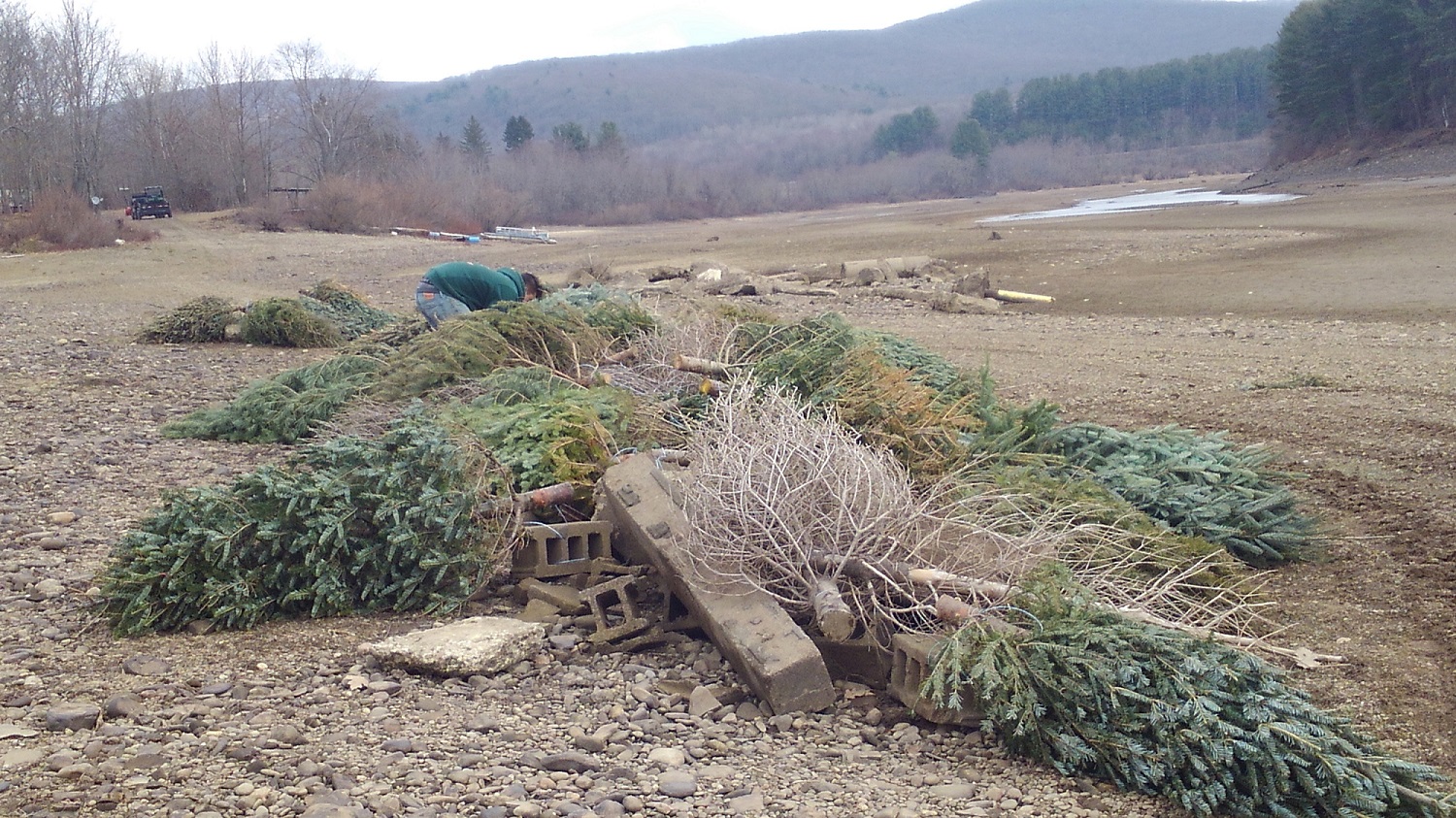
Some of the artificial habitat is made from recycled Christmas trees, which are tied in bundles of three or four and weighed down with cinder blocks. The Nation's Fish and Wildlife Department places this type of artificial habitat in areas identified for spawning and nursing fish, such as Yellow Perch, Crappie, Walleye, and White Bass.
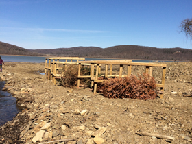
In certain areas wooden structures are also placed to help prevent erosion. The Christmas trees are then tied to the wooden structures to help prevent sediment buildup. Recycled cement rubble that has been removed from local construction projects is also bordered around nursery areas, again to provide shelter and food for young of year fish.
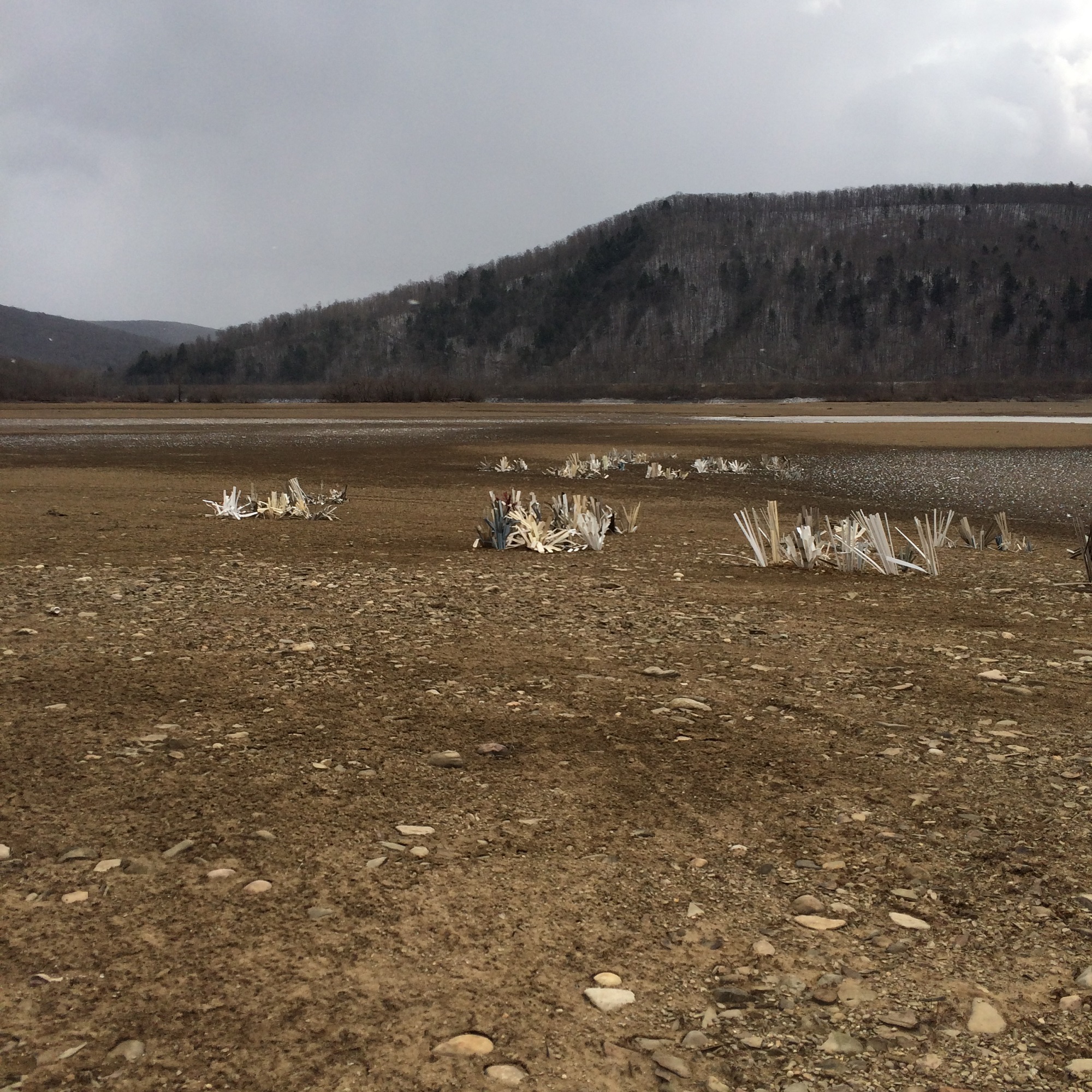
Artificial habitat is also made from recycled vinyl siding that ranges in size from one and a half to three feet in height, which is done to provide a more diverse artificial environment.
Land Locked Fish and Trenches
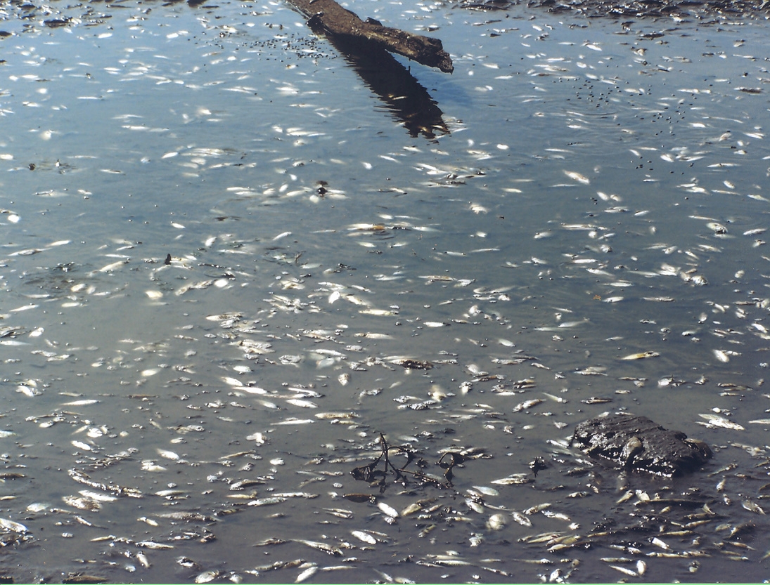
The draining of the reservoir in fall in combination with the sediment buildup that covers spawning and nursery areas leaves many areas of landlocked water that fish get trapped in, leading to mass fish kills. Once landlocked, tens of thousands of young of year fish die because of oxygen degradation, predation, and water evaporation.
Fish species affected by land locking are Crappie, Northern Pike, Muskellunge, Channel Catfish, Walleye, Bullhead, Small Mouth Bass, Large Mouth Bass, White Bass, Yellow Perch, and Paddlefish.
The Seneca Nation of Indian's Fish and Wildlife Department works to combat erosion and the mass loss of landlocked fish by building artificial habitat and digging trenches in the bottom of the Reservoir. During the winter months maintenance to the trenches dug in years past is done.Mapping the Restoration Projects
The Seneca Nation's Geographic Information Services (G.I.S.) Department has helped document and track the various restoration projects related to our river.