| resource | rdf:resource | https://scalar.usc.edu/works/ohiyo/media/a6000390002a.4 |
| versionnumber | ov:versionnumber | 4 |
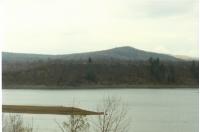
| title | dcterms:title | Erosion at Highbanks Near Highbanks Campground |
| description | dcterms:description | Pictured here is the erosion at Highbanks Campground in 1984. |
| url | art:url | media/A.600.039.0002a.jpg |
| default view | scalar:defaultView | plain |
| was attributed to | prov:wasAttributedTo | https://scalar.usc.edu/works/ohiyo/users/26037 |
| created | dcterms:created | 2018-08-23T17:55:26-07:00 |
| type | rdf:type | http://scalar.usc.edu/2012/01/scalar-ns#Version |
| source | dcterms:source | Seneca Nation Archives Department |
| date | dcterms:date | 2018-07-16 |
| type | dcterms:type | stillimage |
| identifier | dcterms:identifier | A.600.039.0002a |
| subject | dcterms:subject | topography (attribute), riverbanks, mountain ranges, hills, ridges (landforms), banks (landforms), rivers, erosion |
| contributor | dcterms:contributor | Seneca-Iroquois National Museum |
| language | dcterms:language | eng |
| format | dcterms:format | photoprint, electronic |
| format | dcterms:format | image/jpeg |
| format | dcterms:format | reformatted digital |
| alternative | dcterms:alternative | Maps & Boundaries Photo's Highbanks Bank Erosion 1987-1992 |
| conforms to | dcterms:conformsTo | Record has been transformed into MODS from the original accession record. Metadata originally created in a locally modified version of qualified Dublin Core. |
| conforms to | dcterms:conformsTo | languageOfCataloging authority = "iso639-2b"; dcTerm:language |
| conforms to | dcterms:conformsTo | recordCreation Date encoding = "w3cdtf"; dcTerm:date |
| conforms to | dcterms:conformsTo | subject authority = "aat"; dcTerm:subject |
| conforms to | dcterms:conformsTo | subject authority = "tgn"; dcTerm:coverage |
| conforms to | dcterms:conformsTo | dateCreated encoding= "w3cdtf"; dcTerm:temporal |
| coverage | dcterms:coverage | Allegany Reservation, Allegany (county), Kinzua Reservoir (reservoir), Allegany River |
| creator | dcterms:creator | Seneca Nation Maps and Boundaries Department |
| creator | dcterms:creator | This record was created by Dana Reijerkerk. |
| extent | dcterms:extent | 1 photograph; Color, 4" x 6" |
| temporal | dcterms:temporal | 1989-11-06 |
| resource | rdf:resource | https://scalar.usc.edu/works/ohiyo/media/a6000390002a.3 |
| versionnumber | ov:versionnumber | 3 |
| title | dcterms:title | Erosion at Highbanks Near Highbanks Campground |
| description | dcterms:description | Come Fall of every year, much of the bottom of the Reservoir has begun to dry up as the water reserves are lowered at the discretion of the U.S. Army Corps of Engineers. This seasonal lowering and emptying of the water reserves held within the reservoir leaves the land exposed and unprotected to weather elements, which in combination with the water fluctuations throughout the year, expediates the erosion of the shorelines and banks of Ohi:yo'. In addition, many of the shorelines along Ohi:yo' lack the needed plant growth, such as trees, to protect them from erosion. Pictured here is a wide shot that includes the Highbanks Campgrounds of the erosion along the shoreline of Ohi:yo'. |
| url | art:url | media/A.600.039.0002a.jpg |
| default view | scalar:defaultView | meta |
| was attributed to | prov:wasAttributedTo | https://scalar.usc.edu/works/ohiyo/users/26037 |
| created | dcterms:created | 2018-08-03T16:42:10-07:00 |
| type | rdf:type | http://scalar.usc.edu/2012/01/scalar-ns#Version |
| source | dcterms:source | Seneca Nation Archives Department |
| date | dcterms:date | 2018-07-16 |
| type | dcterms:type | stillimage |
| identifier | dcterms:identifier | A.600.039.0002a |
| subject | dcterms:subject | topography (attribute), riverbanks, mountain ranges, hills, ridges (landforms), banks (landforms), rivers, erosion |
| contributor | dcterms:contributor | Seneca-Iroquois National Museum |
| language | dcterms:language | eng |
| abstract | dcterms:abstract | The construction of Kinzua Dam and the Allegany Reservoir was completed in December of 1965. Seneca Nation of Indian land within the Allegany Territory that was inundated with the construction of the Allegany Reservoir is only underwater for part of the year. Come Fall of every year, much of the bottom of the Reservoir has begun to dry up as the water reserves are lowered at the discretion of the U.S. Army Corps of Engineers. This seasonal lowering and emptying of the water reserves held within the reservoir leaves the land exposed and unprotected to weather elements, which in combination with the water fluctuations throughout the year, expediates the erosion of the shorelines and banks of Ohi:yo'. In addition, many of the shorelines along Ohi:yo' lack the needed plant growth, such as trees, to protect them from erosion. Pictured here is a wide shot that includes the Highbanks Campgrounds of the erosion along the shoreline of Ohi:yo'. |
| format | dcterms:format | photoprint, electronic |
| format | dcterms:format | image/jpeg |
| format | dcterms:format | reformatted digital |
| alternative | dcterms:alternative | Maps & Boundaries Photo's Highbanks Bank Erosion 1987-1992 |
| conforms to | dcterms:conformsTo | Record has been transformed into MODS from the original accession record. Metadata originally created in a locally modified version of qualified Dublin Core. |
| conforms to | dcterms:conformsTo | languageOfCataloging authority = "iso639-2b"; dcTerm:language |
| conforms to | dcterms:conformsTo | recordCreation Date encoding = "w3cdtf"; dcTerm:date |
| conforms to | dcterms:conformsTo | subject authority = "aat"; dcTerm:subject |
| conforms to | dcterms:conformsTo | subject authority = "tgn"; dcTerm:coverage |
| conforms to | dcterms:conformsTo | dateCreated encoding= "w3cdtf"; dcTerm:temporal |
| coverage | dcterms:coverage | Allegany Reservation, Allegany (county), Kinzua Reservoir (reservoir), Allegany River |
| creator | dcterms:creator | Seneca Nation Maps and Boundaries Department |
| creator | dcterms:creator | This record was created by Dana Reijerkerk. |
| extent | dcterms:extent | 1 photograph; Color, 4" x 6" |
| temporal | dcterms:temporal | 1989-11-06 |
| resource | rdf:resource | https://scalar.usc.edu/works/ohiyo/media/a6000390002a.2 |
| versionnumber | ov:versionnumber | 2 |
| title | dcterms:title | Erosion at Highbanks Near Highbanks Campground |
| description | dcterms:description | The construction of Kinzua Dam and the Allegany Reservoir was completed in December of 1965. Seneca Nation of Indian land within the Allegany Territory that was inundated with the construction of the Allegany Reservoir is only underwater for part of the year. Come Fall of every year, much of the bottom of the Reservoir has begun to dry up as the water reserves are lowered at the discretion of the U.S. Army Corps of Engineers. This seasonal lowering and emptying of the water reserves held within the reservoir leaves the land exposed and unprotected to weather elements, which in combination with the water fluctuations throughout the year, expediates the erosion of the shorelines and banks of Ohi:yo'. In addition, many of the shorelines along Ohi:yo' lack the needed plant growth, such as trees, to protect them from erosion. Pictured here is a wide shot that includes the Highbanks Campgrounds of the erosion along the shoreline of Ohi:yo'. |
| url | art:url | media/A.600.039.0002a.jpg |
| default view | scalar:defaultView | plain |
| was attributed to | prov:wasAttributedTo | https://scalar.usc.edu/works/ohiyo/users/26037 |
| created | dcterms:created | 2018-08-03T15:58:43-07:00 |
| type | rdf:type | http://scalar.usc.edu/2012/01/scalar-ns#Version |
| source | dcterms:source | Seneca Nation Archives Department |
| date | dcterms:date | 2018-07-16 |
| type | dcterms:type | stillimage |
| identifier | dcterms:identifier | A.600.039.0002a |
| subject | dcterms:subject | topography (attribute), riverbanks, mountain ranges, hills, ridges (landforms), banks (landforms), rivers, erosion |
| contributor | dcterms:contributor | Seneca-Iroquois National Museum |
| language | dcterms:language | eng |
| abstract | dcterms:abstract | The construction of Kinzua Dam and the Allegany Reservoir was completed in December of 1965. Seneca Nation of Indian land within the Allegany Territory that was inundated with the construction of the Allegany Reservoir is only underwater for part of the year. Come Fall of every year, much of the bottom of the Reservoir has begun to dry up as the water reserves are lowered at the discretion of the U.S. Army Corps of Engineers. This seasonal lowering and emptying of the water reserves held within the reservoir leaves the land exposed and unprotected to weather elements, which in combination with the water fluctuations throughout the year, expediates the erosion of the shorelines and banks of Ohi:yo'. In addition, many of the shorelines along Ohi:yo' lack the needed plant growth, such as trees, to protect them from erosion. Pictured here is a wide shot that includes the Highbanks Campgrounds of the erosion along the shoreline of Ohi:yo'. |
| format | dcterms:format | photoprint, electronic |
| format | dcterms:format | image/jpeg |
| format | dcterms:format | reformatted digital |
| alternative | dcterms:alternative | Maps & Boundaries Photo's Highbanks Bank Erosion 1987-1992 |
| conforms to | dcterms:conformsTo | Record has been transformed into MODS from the original accession record. Metadata originally created in a locally modified version of qualified Dublin Core. |
| conforms to | dcterms:conformsTo | languageOfCataloging authority = "iso639-2b"; dcTerm:language |
| conforms to | dcterms:conformsTo | recordCreation Date encoding = "w3cdtf"; dcTerm:date |
| conforms to | dcterms:conformsTo | subject authority = "aat";dcTerm:subject |
| conforms to | dcterms:conformsTo | subject authority = "tgn"; dcTerm:coverage |
| conforms to | dcterms:conformsTo | dateCreated encoding= "w3cdtf"; dcTerm:temporal |
| coverage | dcterms:coverage | Allegany Reservation, Allegany (county), Kinzua Reservoir (reservoir), Allegany River |
| creator | dcterms:creator | Seneca Nation Maps and Boundaries Department |
| creator | dcterms:creator | This record was created by Dana Reijerkerk. |
| extent | dcterms:extent | 1 photograph; Color, 4" x 6" |
| temporal | dcterms:temporal | 1989-11-06 |
| resource | rdf:resource | https://scalar.usc.edu/works/ohiyo/media/a6000390002a.1 |
| versionnumber | ov:versionnumber | 1 |
| title | dcterms:title | Erosion at Highbanks with Highbanks Campground |
| description | dcterms:description | Photograph of the erosion at Highbanks showing the highbanks along the river and Highbanks Campgrounds. |
| url | art:url | media/A.600.039.0002a.jpg |
| default view | scalar:defaultView | plain |
| was attributed to | prov:wasAttributedTo | https://scalar.usc.edu/works/ohiyo/users/26037 |
| created | dcterms:created | 2018-07-25T15:28:34-07:00 |
| type | rdf:type | http://scalar.usc.edu/2012/01/scalar-ns#Version |
| source | dcterms:source | Seneca Nation Archives Department |
| date | dcterms:date | 2018-07-16 |
| type | dcterms:type | stillimage |
| identifier | dcterms:identifier | A.600.039.0002a |
| subject | dcterms:subject | topography (attribute), riverbanks, mountain ranges, hills, ridges (landforms), banks (landforms), rivers, erosion |
| contributor | dcterms:contributor | Seneca-Iroquois National Museum |
| language | dcterms:language | eng |
| abstract | dcterms:abstract | Photograph of the erosion at Highbanks showing the highbanks along the river and Highbanks Campgrounds. |
| format | dcterms:format | photoprint, electronic |
| format | dcterms:format | image/jpeg |
| format | dcterms:format | reformatted digital |
| alternative | dcterms:alternative | Maps & Boundaries Photo's Highbanks Bank Erosion 1987-1992 |
| conforms to | dcterms:conformsTo | Record has been transformed into MODS from the original accession record. Metadata originally created in a locally modified version of qualified Dublin Core. |
| conforms to | dcterms:conformsTo | languageOfCataloging authority = "iso639-2b"; dcTerm:language |
| conforms to | dcterms:conformsTo | recordCreation Date encoding = "w3cdtf"; dcTerm:date |
| conforms to | dcterms:conformsTo | subject authority = "aat";dcTerm:subject |
| conforms to | dcterms:conformsTo | subject authority = "tgn"; dcTerm:coverage |
| conforms to | dcterms:conformsTo | dateCreated encoding= "w3cdtf"; dcTerm:temporal |
| coverage | dcterms:coverage | Allegany Reservation, Allegany (county), Kinzua Reservoir (reservoir), Allegany River |
| creator | dcterms:creator | Seneca Nation Maps and Boundaries Department |
| creator | dcterms:creator | This record was created by Dana Reijerkerk. |
| extent | dcterms:extent | 1 photograph; Color, 4" x 6" |
| temporal | dcterms:temporal | 1989-11-06 |