| resource | rdf:resource | https://scalar.usc.edu/works/ohiyo/media/8510030245.7 |
| versionnumber | ov:versionnumber | 7 |
| title | dcterms:title | Walter Taylor, George Heron |
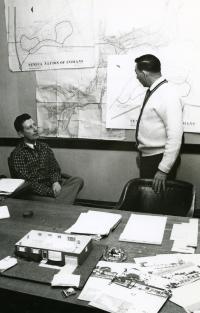
| description | dcterms:description | Walter Taylor, the national representative of the American Indian Program of the American Friends Service Committee, a Society of Friends organization, is speaking with George Heron (SNI President 1958-1960, 1962-1964) in front of two of the proposed resettlement area maps for displaced Seneca families (Jimersontown and Steamburg) that the U.S. Army Corps of Engineers created. |
| url | art:url | media/85.1003.0245.jpg |
| default view | scalar:defaultView | plain |
| was attributed to | prov:wasAttributedTo | https://scalar.usc.edu/works/ohiyo/users/26037 |
| created | dcterms:created | 2018-08-22T19:05:46-07:00 |
| type | rdf:type | http://scalar.usc.edu/2012/01/scalar-ns#Version |
| source | dcterms:source | Seneca-Iroquois National Museum |
| type | dcterms:type | stillimage |
| identifier | dcterms:identifier | 85.1003.0245 |
| subject | dcterms:subject | independent sovereign nations, flood dams, gravity dams, rolled-fill dams, rivers |
| contributor | dcterms:contributor | Seneca-Iroquois National Museum |
| language | dcterms:language | eng |
| abstract | dcterms:abstract | Walter Taylor, the national representative of the American Indian Program of the American Friends Service Committee, a Society of Friends organization, is speaking with George Heron (SNI President 1958-1960, 1962-1964) in front of two of the proposed resettlement area maps for displaced Seneca families (Jimerson Town and Steamburg) that the U.S. Army Corps of Engineers created. Between May 1961 and January of 1962 the Seneca Nation of Indians and the U.S. Army Corps of Engineers negotiated the individual landowner boundary lines of the "take" areas on the Army Corps proposed resettlement maps. |
| format | dcterms:format | photoprint, electronic |
| format | dcterms:format | image/jpeg |
| format | dcterms:format | reformatted digital |
| conforms to | dcterms:conformsTo | Record has been transformed into MODS from the original accession record. Metadata originally created in a locally modified version of qualified Dublin Core. |
| conforms to | dcterms:conformsTo | languageOfCataloging authority = "iso639-2b"; dcTerm:language |
| conforms to | dcterms:conformsTo | subject authority = "aat"; dcTerm:subject |
| conforms to | dcterms:conformsTo | subject authority = "tgn"; dcTerm:coverage |
| conforms to | dcterms:conformsTo | dc:temporal conforms to Timeline JS. |
| coverage | dcterms:coverage | New York (state), Cattaraugus (county), Salamanca (inhabited place), Allegany Reservation, Allegany River |
| creator | dcterms:creator | This record was created by Dana Reijerkerk. |
| creator | dcterms:creator | Ted Hetzel |
| extent | dcterms:extent | 1 photograph; Black and White, Glossy 5" x 7" |
| temporal | dcterms:temporal | 05/00/1961-01/00/1962 |
| resource | rdf:resource | https://scalar.usc.edu/works/ohiyo/media/8510030245.6 |
| versionnumber | ov:versionnumber | 6 |
| title | dcterms:title | Walter Taylor, George Heron |
| description | dcterms:description | Walter Taylor, the national representative of the American Indian Program of the American Friends Service Committee, a Society of Friends organization, is speaking with George Heron (SNI President 1958-1960, 1962-1964) in front of two of the proposed resettlement area maps for displaced Seneca families (Jimersontown and Steamburg) that the U.S. Army Corps of Engineers created. |
| url | art:url | media/85.1003.0245.jpg |
| default view | scalar:defaultView | plain |
| was attributed to | prov:wasAttributedTo | https://scalar.usc.edu/works/ohiyo/users/26037 |
| created | dcterms:created | 2018-08-21T17:48:45-07:00 |
| type | rdf:type | http://scalar.usc.edu/2012/01/scalar-ns#Version |
| source | dcterms:source | Seneca-Iroquois National Museum |
| type | dcterms:type | stillimage |
| identifier | dcterms:identifier | 85.1003.0245 |
| subject | dcterms:subject | independent sovereign nations, flood dams, gravity dams, rolled-fill dams, rivers |
| contributor | dcterms:contributor | Seneca-Iroquois National Museum |
| language | dcterms:language | eng |
| abstract | dcterms:abstract | Walter Taylor, the national representative of the American Indian Program of the American Friends Service Committee, a Society of Friends organization, is speaking with George Heron (SNI President 1958-1960, 1962-1964) in front of two of the proposed resettlement area maps for displaced Seneca families (Jimerson Town and Steamburg) that the U.S. Army Corps of Engineers created. Between May 1961 and January of 1962 the Seneca Nation of Indians and the U.S. Army Corps of Engineers negotiated the individual landowner boundary lines of the "take" areas on the Army Corps proposed resettlement maps. |
| format | dcterms:format | photoprint, electronic |
| format | dcterms:format | image/jpeg |
| format | dcterms:format | reformatted digital |
| conforms to | dcterms:conformsTo | Record has been transformed into MODS from the original accession record. Metadata originally created in a locally modified version of qualified Dublin Core. |
| conforms to | dcterms:conformsTo | languageOfCataloging authority = "iso639-2b"; dcTerm:language |
| conforms to | dcterms:conformsTo | subject authority = "aat"; dcTerm:subject |
| conforms to | dcterms:conformsTo | subject authority = "tgn"; dcTerm:coverage |
| conforms to | dcterms:conformsTo | dc:temporal conforms to JS Timeline. |
| coverage | dcterms:coverage | New York (state), Cattaraugus (county), Salamanca (inhabited place), Allegany Reservation, Allegany River |
| creator | dcterms:creator | This record was created by Dana Reijerkerk. |
| creator | dcterms:creator | Ted Hetzel |
| extent | dcterms:extent | 1 photograph; Black and White, Glossy 5" x 7" |
| temporal | dcterms:temporal | 05/00/1961-01/00/1962 |
| resource | rdf:resource | https://scalar.usc.edu/works/ohiyo/media/8510030245.5 |
| versionnumber | ov:versionnumber | 5 |
| title | dcterms:title | Walter Taylor, George Heron |
| description | dcterms:description | Walter Taylor, the national representative of the American Indian Program of the American Friends Service Committee, a Society of Friends organization, is speaking with George Heron (SNI President 1958-1960, 1962-1964) in front of two of the proposed resettlement area maps for displaced Seneca families (Jimersontown and Steamburg) that the U.S. Army Corps of Engineers created. |
| url | art:url | media/85.1003.0245.jpg |
| default view | scalar:defaultView | meta |
| was attributed to | prov:wasAttributedTo | https://scalar.usc.edu/works/ohiyo/users/26037 |
| created | dcterms:created | 2018-08-21T00:10:37-07:00 |
| type | rdf:type | http://scalar.usc.edu/2012/01/scalar-ns#Version |
| source | dcterms:source | Seneca-Iroquois National Museum |
| type | dcterms:type | stillimage |
| identifier | dcterms:identifier | 85.1003.0245 |
| subject | dcterms:subject | independent sovereign nations, flood dams, gravity dams, rolled-fill dams, rivers |
| contributor | dcterms:contributor | Seneca-Iroquois National Museum |
| language | dcterms:language | eng |
| abstract | dcterms:abstract | Walter Taylor, the national representative of the American Indian Program of the American Friends Service Committee, a Society of Friends organization, is speaking with George Heron (SNI President 1958-1960, 1962-1964) in front of two of the proposed resettlement area maps for displaced Seneca families (Jimersontown and Steamburg) that the U.S. Army Corps of Engineers created. Between April and September of 1961, the U.S. Army Corps of Engineers surveyed and mapped out the flowage and clearing easements for the Allegeny Reservoir, part of which would extend into Seneca Nation of Indians land on the Allegany Territory. Between May 1961 and January of 1962 the Seneca Nation of Indians and the U.S. Army Corps of Engineers negotiated the individual landowner boundary lines of the "take" areas: Seneca Nation land below the 1365 elevation line that the U.S. Army Corps was taking to be a part of the Reservoir. Seneca Nation officials were given copies of these maps and held personal meetings with families who lived in the "take" areas in addition to discussing the maps' boundaries among Council. |
| format | dcterms:format | photoprint, electronic |
| format | dcterms:format | image/jpeg |
| format | dcterms:format | reformatted digital |
| conforms to | dcterms:conformsTo | Record has been transformed into MODS from the original accession record. Metadata originally created in a locally modified version of qualified Dublin Core. |
| conforms to | dcterms:conformsTo | languageOfCataloging authority = "iso639-2b"; dcTerm:language |
| conforms to | dcterms:conformsTo | subject authority = "aat"; dcTerm:subject |
| conforms to | dcterms:conformsTo | subject authority = "tgn"; dcTerm:coverage |
| conforms to | dcterms:conformsTo | dc:temporal conforms to JS Timeline. |
| coverage | dcterms:coverage | New York (state), Cattaraugus (county), Salamanca (inhabited place), Allegany Reservation, Allegany River |
| creator | dcterms:creator | This record was created by Dana Reijerkerk. |
| creator | dcterms:creator | Ted Hetzel |
| extent | dcterms:extent | 1 photograph; Black and White, Glossy 5" x 7" |
| temporal | dcterms:temporal | 05/00/1961-01/00/1962 |
| resource | rdf:resource | https://scalar.usc.edu/works/ohiyo/media/8510030245.4 |
| versionnumber | ov:versionnumber | 4 |
| title | dcterms:title | Walter Taylor, George Heron |
| description | dcterms:description | Walter Taylor, the national representative of the American Indian Program of the American Friends Service Committee, a Society of Friends organization, is speaking with George Heron (SNI President 1958-1960, 1962-1964) in front of two of the proposed resettlement area maps for displaced Seneca families (Jimersontown and Steamburg) that the U.S. Army Corps of Engineers created. |
| url | art:url | media/85.1003.0245.jpg |
| default view | scalar:defaultView | meta |
| was attributed to | prov:wasAttributedTo | https://scalar.usc.edu/works/ohiyo/users/26037 |
| created | dcterms:created | 2018-08-21T00:04:30-07:00 |
| type | rdf:type | http://scalar.usc.edu/2012/01/scalar-ns#Version |
| source | dcterms:source | Seneca-Iroquois National Museum |
| type | dcterms:type | stillimage |
| identifier | dcterms:identifier | 85.1003.0245 |
| subject | dcterms:subject | independent sovereign nations, flood dams, gravity dams, rolled-fill dams, rivers |
| contributor | dcterms:contributor | Seneca-Iroquois National Museum |
| language | dcterms:language | eng |
| abstract | dcterms:abstract | Walter Taylor, the national representative of the American Indian Program of the American Friends Service Committee, a Society of Friends organization, is speaking with George Heron (SNI President 1958-1960, 1962-1964) in front of two of the proposed resettlement area maps for displaced Seneca families (Jimersontown and Steamburg) that the U.S. Army Corps of Engineers created. Between April and September of 1961, the U.S. Army Corps of Engineers surveyed and mapped out the flowage and clearing easements for the Allegeny Reservoir, part of which would extend into Seneca Nation of Indians land on the Allegany Territory. Between May 1961 and January of 1962 the Seneca Nation of Indians and the U.S. Army Corps of Engineers negotiated the individual landowner boundary lines of the "take" areas: Seneca Nation land below the 1365 elevation line that the U.S. Army Corps was taking to be a part of the Reservoir. Seneca Nation officials were given copies of these maps and held personal meetings with families who lived in the "take" areas in addition to discussing the maps' boundaries among Council. |
| format | dcterms:format | photoprint, electronic |
| format | dcterms:format | image/jpeg |
| format | dcterms:format | reformatted digital |
| conforms to | dcterms:conformsTo | Record has been transformed into MODS from the original accession record. Metadata originally created in a locally modified version of qualified Dublin Core. |
| conforms to | dcterms:conformsTo | languageOfCataloging authority = "iso639-2b"; dcTerm:language |
| conforms to | dcterms:conformsTo | subject authority = "aat"; dcTerm:subject |
| conforms to | dcterms:conformsTo | subject authority = "tgn"; dcTerm:coverage |
| coverage | dcterms:coverage | New York (state), Cattaraugus (county), Salamanca (inhabited place), Allegany Reservation, Allegany River |
| creator | dcterms:creator | This record was created by Dana Reijerkerk. |
| creator | dcterms:creator | Ted Hetzel |
| extent | dcterms:extent | 1 photograph; Black and White, Glossy 5" x 7" |
| temporal | dcterms:temporal | 05/00/1961-01/00/1962 |
| resource | rdf:resource | https://scalar.usc.edu/works/ohiyo/media/8510030245.3 |
| versionnumber | ov:versionnumber | 3 |
| title | dcterms:title | Walter Taylor, George Heron |
| description | dcterms:description | Walter Taylor, the national representative of the American Indian Program of the American Friends Service Committee, a Society of Friends organization, is speaking with George Heron (SNI President 1958-1960, 1962-1964) in front of two of the proposed resettlement area maps for displaced Seneca families (Jimersontown and Steamburg) that the U.S. Army Corps of Engineers created. |
| url | art:url | media/85.1003.0245.jpg |
| default view | scalar:defaultView | meta |
| was attributed to | prov:wasAttributedTo | https://scalar.usc.edu/works/ohiyo/users/26037 |
| created | dcterms:created | 2018-08-03T17:13:38-07:00 |
| type | rdf:type | http://scalar.usc.edu/2012/01/scalar-ns#Version |
| source | dcterms:source | Seneca-Iroquois National Museum |
| date | dcterms:date | 2018-07-18 |
| type | dcterms:type | stillimage |
| identifier | dcterms:identifier | 85.1003.0245 |
| subject | dcterms:subject | independent sovereign nations, flood dams, gravity dams, rolled-fill dams, rivers |
| contributor | dcterms:contributor | Seneca-Iroquois National Museum |
| language | dcterms:language | eng |
| abstract | dcterms:abstract | Walter Taylor, the national representative of the American Indian Program of the American Friends Service Committee, a Society of Friends organization, is speaking with George Heron (SNI President 1958-1960, 1962-1964) in front of two of the proposed resettlement area maps for displaced Seneca families (Jimersontown and Steamburg) that the U.S. Army Corps of Engineers created. Between April and September of 1961, the U.S. Army Corps of Engineers surveyed and mapped out the flowage and clearing easements for the Allegeny Reservoir, part of which would extend into Seneca Nation of Indians land on the Allegany Territory. Between May 1961 and January of 1962 the Seneca Nation of Indians and the U.S. Army Corps of Engineers negotiated the individual landowner boundary lines of the "take" areas: Seneca Nation land below the 1365 elevation line that the U.S. Army Corps was taking to be a part of the Reservoir. Seneca Nation officials were given copies of these maps and held personal meetings with families who lived in the "take" areas in addition to discussing the maps' boundaries among Council. |
| format | dcterms:format | photoprint, electronic |
| format | dcterms:format | image/jpeg |
| format | dcterms:format | reformatted digital |
| conforms to | dcterms:conformsTo | Record has been transformed into MODS from the original accession record. Metadata originally created in a locally modified version of qualified Dublin Core. |
| conforms to | dcterms:conformsTo | dateCreated encoding= "w3cdtf"; dcTerm:temporal |
| conforms to | dcterms:conformsTo | languageOfCataloging authority = "iso639-2b"; dcTerm:language |
| conforms to | dcterms:conformsTo | recordCreation Date encoding = "w3cdtf"; dcTerm:date |
| conforms to | dcterms:conformsTo | subject authority = "aat"; dcTerm:subject |
| conforms to | dcterms:conformsTo | subject authority = "tgn"; dcTerm:coverage |
| coverage | dcterms:coverage | New York (state), Cattaraugus (county), Salamanca (inhabited place), Allegany Reservation, Allegany River |
| creator | dcterms:creator | This record was created by Dana Reijerkerk. |
| creator | dcterms:creator | Ted Hetzel |
| extent | dcterms:extent | 1 photograph; Black and White, Glossy 5" x 7" |
| temporal | dcterms:temporal | 1961-05/1962-01 |
| resource | rdf:resource | https://scalar.usc.edu/works/ohiyo/media/8510030245.2 |
| versionnumber | ov:versionnumber | 2 |
| title | dcterms:title | Walter Taylor, George Heron |
| description | dcterms:description | Walter Taylor, the national representative of the American Indian Program of the American Friends Service Committee, a Quaker organization, is speaking with George Heron (SNI President 1958-1960, 1962-1964) in front of Army Corps of Engineer maps of Jimersontown and Steamberg, two of the relocation areas for the Nation's land that was going to be inundated by the Allegany Reservoir. |
| url | art:url | media/85.1003.0245.jpg |
| default view | scalar:defaultView | plain |
| was attributed to | prov:wasAttributedTo | https://scalar.usc.edu/works/ohiyo/users/26037 |
| created | dcterms:created | 2018-07-25T15:21:57-07:00 |
| type | rdf:type | http://scalar.usc.edu/2012/01/scalar-ns#Version |
| source | dcterms:source | Seneca-Iroquois National Museum |
| date | dcterms:date | 2018-07-18 |
| type | dcterms:type | stillimage |
| identifier | dcterms:identifier | 85.1003.0245 |
| subject | dcterms:subject | independent sovereign nations, flood dams, gravity dams, rolled-fill dams, rivers |
| contributor | dcterms:contributor | Seneca-Iroquois National Museum |
| language | dcterms:language | eng |
| abstract | dcterms:abstract | Walter Taylor, the national representative of the American Indian Program of the American Friends Service Committee, a Quaker organization, is speaking with George Heron (SNI President 1958-1960, 1962-1964) in front of Army Corps of Engineer maps of Jimersontown and Steamberg, two of the relocation areas for the Nation's land that was going to be inundated by the Allegany Reservoir. |
| format | dcterms:format | photoprint, electronic |
| format | dcterms:format | image/jpeg |
| format | dcterms:format | reformatted digital |
| conforms to | dcterms:conformsTo | Record has been transformed into MODS from the original accession record. Metadata originally created in a locally modified version of qualified Dublin Core. |
| conforms to | dcterms:conformsTo | |
| conforms to | dcterms:conformsTo | languageOfCataloging authority = "iso639-2b"; dcTerm:language |
| conforms to | dcterms:conformsTo | recordCreation Date encoding = "w3cdtf"; dcTerm:date |
| conforms to | dcterms:conformsTo | subject authority = "aat";dcTerm:subject |
| conforms to | dcterms:conformsTo | subject authority = "tgn"; dcTerm:coverage |
| coverage | dcterms:coverage | New York (state), Cattaraugus (county), Salamanca (inhabited place), Allegany Reservation, Allegany River |
| creator | dcterms:creator | This record was created by Dana Reijerkerk. |
| creator | dcterms:creator | Ted Hetzel |
| extent | dcterms:extent | 1 photograph; Black and White, Glossy 5" x 7" |
| temporal | dcterms:temporal | 1964/1965 |