Campus Maps
1 media/Big Pueblo Map.png media/Hospital Map South.png 2022-03-15T10:35:17-07:00 Alexander J Moore 534d3d5224d8b5830fb6e191d6df60cc22362a04 40165 22 gallery 1158292 2022-04-28T17:06:14-07:00 Alexander J Moore 534d3d5224d8b5830fb6e191d6df60cc22362a04Page
| resource | rdf:resource | https://scalar.usc.edu/works/colorado-state-hospital--1/campus-map |
| type | rdf:type | http://scalar.usc.edu/2012/01/scalar-ns#Composite |
| is live | scalar:isLive | 1 |
| background | scalar:background | media/Big Pueblo Map.png |
| banner | scalar:banner | media/Hospital Map South.png |
| was attributed to | prov:wasAttributedTo | https://scalar.usc.edu/works/colorado-state-hospital--1/users/35859 |
| created | dcterms:created | 2022-03-15T10:35:17-07:00 |
Version 22
| resource | rdf:resource | https://scalar.usc.edu/works/colorado-state-hospital--1/campus-map.22 |
| versionnumber | ov:versionnumber | 22 |
| title | dcterms:title | Campus Maps |
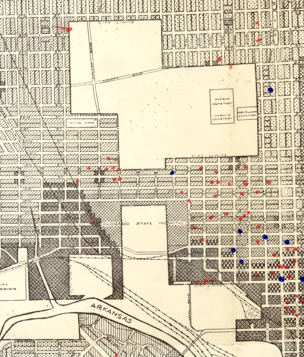
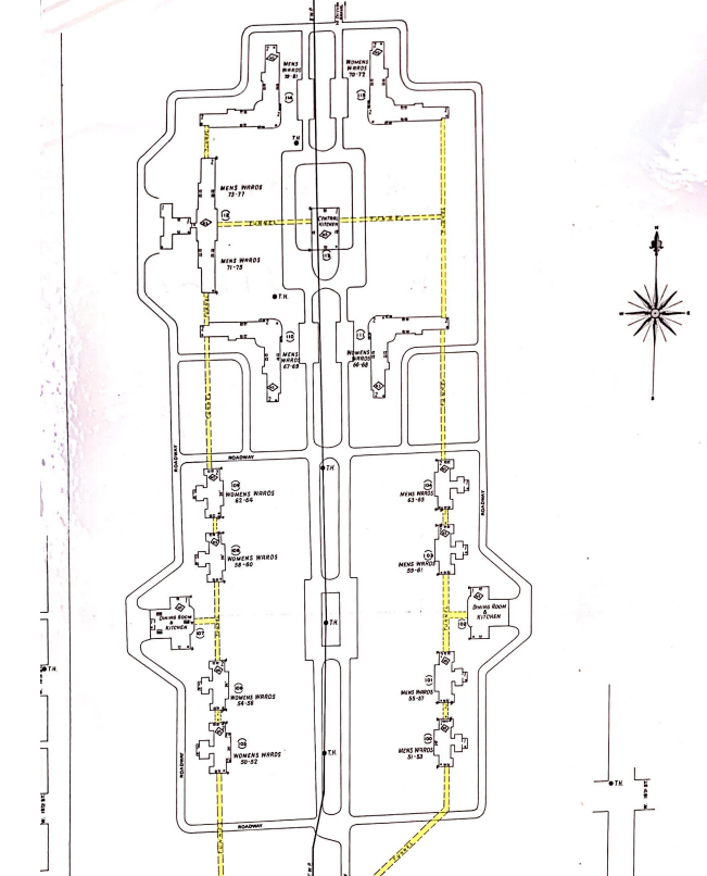
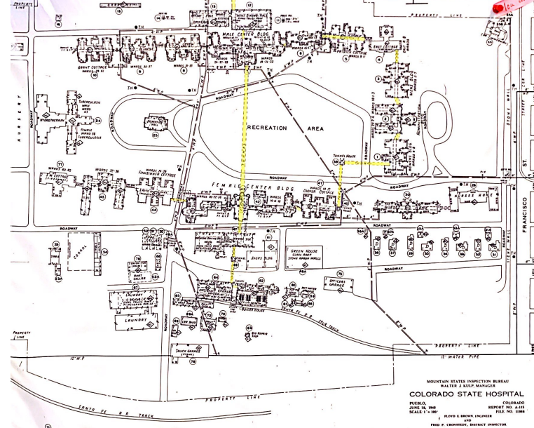
| content | sioc:content | The Colorado State Mental Hospital is located in western Pueblo which has now become an area dominated by modern housing. Originally the vast emptiness surrounding the Hospital made it one of the only discernable features of this area, but now the densely populated area around even makes it difficult to find. The map below shows the campus of the Colorado State Hospital as well as a large unused swathe of land to the north. The constant expansion of the hospital resulted in them quickly using all their available space on their original property. The expansion of the hospital was the chief reason they eventually spread their campus to the north throughout the 40's and 50's. The map above was drawn in 1936 and interestingly does not show that the State Hospital had mad their move to the northern field. Today however, most of the campus that remains in function is located to the north, a few blocks away from the original campus. The split nature of the campus presented some interesting dilemmas for the staff at the hospital. Patients, resources, food, and personnel were constantly being transported between the two sections of the campus, which is separated by about 5 city blocks. Tunnels were eventually built between the campuses that made this easier, though their dark hallways made it possible for patients to hide there for extended periods of time during escape attempts. Today, the tunnels are sealed and unused due to asbestos. The first image in the media gallery shows the campus and surrounding neighborhood. The second and third images are a detailed look at the two sections of the Hospital campus. The first image is the northern section near the cemetery: the second section is indicated by "Colorado State Hospital" on the first map. |
| default view | scalar:defaultView | gallery |
| continue to content id | scalar:continue_to_content_id | 1158292 |
| was attributed to | prov:wasAttributedTo | https://scalar.usc.edu/works/colorado-state-hospital--1/users/35859 |
| created | dcterms:created | 2022-04-28T17:06:14-07:00 |
| type | rdf:type | http://scalar.usc.edu/2012/01/scalar-ns#Version |
Version 21
| resource | rdf:resource | https://scalar.usc.edu/works/colorado-state-hospital--1/campus-map.21 |
| versionnumber | ov:versionnumber | 21 |
| title | dcterms:title | Campus Maps |
| content | sioc:content | The Colorado State Mental Hospital is located in western Pueblo which has now become an area dominated by modern housing. Originally the vast emptiness surrounding the Hospital made it one of the only discernable features of this area, but now the densely populated area around even makes it difficult to find. The map below shows the campus of the Colorado State Hospital as well as a large unused swathe of land to the north. The constant expansion of the hospital resulted in them quickly using all their available space on their original property. The expansion of the hospital was the chief reason they eventually spread their campus to the north throughout the 40's and 50's. The map above was drawn in 1936 and interestingly does not show that the State Hospital had mad their move to the northern field. Today however, most of the campus that remains in function is located to the north, a few blocks away from the original campus. The split nature of the campus presented some interesting dilemmas for the staff at the hospital. Patients, resources, food, and personnel were constantly being transported between the two sections of the campus, which is separated by about 5 city blocks. Tunnels were eventually built between the campuses that made this easier, though their dark hallways made it possible for patients to hide there for extended periods of time during escape attempts. Today, the tunnels are sealed and unused due to asbestos. The first image in the media gallery shows the campus and surrounding neighborhood. The second and third images are a detailed look at the two sections of the Hospital campus. The first image is the northern section near the cemetery: the second section is indicated by "Colorado State Hospital" on the first map. |
| default view | scalar:defaultView | gallery |
| continue to content id | scalar:continue_to_content_id | 1158292 |
| was attributed to | prov:wasAttributedTo | https://scalar.usc.edu/works/colorado-state-hospital--1/users/35859 |
| created | dcterms:created | 2022-04-28T17:06:01-07:00 |
| type | rdf:type | http://scalar.usc.edu/2012/01/scalar-ns#Version |
Version 20
| resource | rdf:resource | https://scalar.usc.edu/works/colorado-state-hospital--1/campus-map.20 |
| versionnumber | ov:versionnumber | 20 |
| title | dcterms:title | Campus Maps |
| content | sioc:content | The Colorado State Mental Hospital is located in western Pueblo which has now become an area dominated by modern housing. Originally the vast emptiness surrounding the Hospital made it one of the only discernable features of this area, but now the densely populated area around even makes it difficult to find. The map below shows the campus of the Colorado State Hospital as well as a large unused swathe of land to the north. The constant expansion of the hospital resulted in them quickly using all their available space on their original property. The expansion of the hospital was the chief reason they eventually spread their campus to the north throughout the 40's and 50's. The map above was drawn in 1936 and interestingly does not show that the State Hospital had mad their move to the northern field. Today however, most of the campus that remains in function is located to the north, a few blocks away from the original campus. The split nature of the campus presented some interesting dilemmas for the staff at the hospital. Patients, resources, food, and personnel were constantly being transported between the two sections of the campus, which is separated by about 5 city blocks. Tunnels were eventually built between the campuses that made this easier, though their dark hallways made it possible for patients to hide there for extended periods of time during escape attempts. Today, the tunnels are sealed and unused due to asbestos. The first image in the media gallery shows the campus and surrounding neighborhood. The second and third images are a detailed look at the two sections of the Hospital campus. The first image is the northern section near the cemetery: the second section is indicated by "Colorado State Hospital" on the first map. |
| default view | scalar:defaultView | gallery |
| continue to content id | scalar:continue_to_content_id | 1158292 |
| was attributed to | prov:wasAttributedTo | https://scalar.usc.edu/works/colorado-state-hospital--1/users/35859 |
| created | dcterms:created | 2022-04-28T17:05:07-07:00 |
| type | rdf:type | http://scalar.usc.edu/2012/01/scalar-ns#Version |
Version 19
| resource | rdf:resource | https://scalar.usc.edu/works/colorado-state-hospital--1/campus-map.19 |
| versionnumber | ov:versionnumber | 19 |
| title | dcterms:title | Campus Map |
| content | sioc:content | The Colorado State Mental Hospital is located in western Pueblo which has now become an area dominated by modern housing. Originally the vast emptiness surrounding the Hospital made it one of the only discernable features of this area, but now the densely populated area around even makes it difficult to find. The map below shows the campus of the Colorado State Hospital as well as a large unused swathe of land to the north. The constant expansion of the hospital resulted in them quickly using all their available space on their original property. The expansion of the hospital was the chief reason they eventually spread their campus to the north throughout the 40's and 50's. The map above was drawn in 1936 and interestingly does not show that the State Hospital had mad their move to the northern field. Today however, most of the campus that remains in function is located to the north, a few blocks away from the original campus. The split nature of the campus presented some interesting dilemmas for the staff at the hospital. Patients, resources, food, and personnel were constantly being transported between the two sections of the campus, which is separated by about 5 city blocks. Tunnels were eventually built between the campuses that made this easier, though their dark hallways made it possible for patients to hide there for extended periods of time during escape attempts. Today, the tunnels are sealed and unused due to asbestos. The first image in the media gallery shows the campus and surrounding neighborhood. The second and third images are a detailed look at the two sections of the Hospital campus. The first image is the northern section near the cemetery: the second section is indicated by "Colorado State Hospital" on the first map. |
| default view | scalar:defaultView | gallery |
| continue to content id | scalar:continue_to_content_id | 1158292 |
| was attributed to | prov:wasAttributedTo | https://scalar.usc.edu/works/colorado-state-hospital--1/users/35859 |
| created | dcterms:created | 2022-04-28T16:55:07-07:00 |
| type | rdf:type | http://scalar.usc.edu/2012/01/scalar-ns#Version |
Version 18
| resource | rdf:resource | https://scalar.usc.edu/works/colorado-state-hospital--1/campus-map.18 |
| versionnumber | ov:versionnumber | 18 |
| title | dcterms:title | Campus Map |
| content | sioc:content | The Colorado State Mental Hospital is located in western Pueblo which has now become an area dominated by modern housing. Originally the vast emptiness surrounding the Hospital made it one of the only discernable features of this area, but now the densely populated area around even makes it difficult to find. The map below shows the campus of the Colorado State Hospital as well as a large unused swathe of land to the north. The constant expansion of the hospital resulted in them quickly using all their available space on their original property. The expansion of the hospital was the chief reason they eventually spread their campus to the north throughout the 40's and 50's. The map above was drawn in 1936 and interestingly does not show that the State Hospital had mad their move to the northern field. Today however, most of the campus that remains in function is located to the north, a few blocks away from the original campus. The split nature of the campus presented some interesting dilemmas for the staff at the hospital. Patients, resources, food, and personnel were constantly being transported between the two sections of the campus, which is separated by about 5 city blocks. Tunnels were eventually built between the campuses that made this easier, though their dark hallways made it possible for patients to hide there for extended periods of time during escape attempts. Today, the tunnels are sealed and unused due to asbestos. |
| default view | scalar:defaultView | gallery |
| continue to content id | scalar:continue_to_content_id | 1158292 |
| was attributed to | prov:wasAttributedTo | https://scalar.usc.edu/works/colorado-state-hospital--1/users/35859 |
| created | dcterms:created | 2022-04-28T16:52:25-07:00 |
| type | rdf:type | http://scalar.usc.edu/2012/01/scalar-ns#Version |
Version 17
| resource | rdf:resource | https://scalar.usc.edu/works/colorado-state-hospital--1/campus-map.17 |
| versionnumber | ov:versionnumber | 17 |
| title | dcterms:title | Campus Map |
| content | sioc:content | The Colorado State Mental Hospital is located in western Pueblo which has now become an area dominated by modern housing. Originally the vast emptiness surrounding the Hospital made it one of the only discernable features of this area, but now the densely populated area around even makes it difficult to find. The map below shows the campus of the Colorado State Hospital as well as a large unused swathe of land to the north. The constant expansion of the hospital resulted in them quickly using all their available space on their original property. The expansion of the hospital was the chief reason they eventually spread their campus to the north throughout the 40's and 50's. The map above was drawn in 1936 and interestingly does not show that the State Hospital had mad their move to the northern field. Today however, most of the campus that remains in function is located to the north, a few blocks away from the original campus. The split nature of the campus presented some interesting dilemmas for the staff at the hospital. Patients, resources, food, and personnel were constantly being transported between the two sections of the campus, which is separated by about 5 city blocks. Tunnels were eventually built between the campuses that made this easier, though their dark hallways made it possible for patients to hide there for extended periods of time during escape attempts. Today, the tunnels are sealed and unused due to asbestos. The image below is an aerial view of the part of town where the hospital was located and its differences to the modern day landscape are striking. The picture itself was taken in 1960 and is contained in the Pueblo County Library Archives. The hospital and its grounds are located in the upper left side of the image, near the rivers bend. In stark contrast to todays view, the hospital was surrounded by empty space. |
| default view | scalar:defaultView | gallery |
| continue to content id | scalar:continue_to_content_id | 1158292 |
| was attributed to | prov:wasAttributedTo | https://scalar.usc.edu/works/colorado-state-hospital--1/users/35859 |
| created | dcterms:created | 2022-04-28T16:51:36-07:00 |
| type | rdf:type | http://scalar.usc.edu/2012/01/scalar-ns#Version |
Version 16
| resource | rdf:resource | https://scalar.usc.edu/works/colorado-state-hospital--1/campus-map.16 |
| versionnumber | ov:versionnumber | 16 |
| title | dcterms:title | Campus Map |
| content | sioc:content | The Colorado State Mental Hospital is located in western Pueblo which has now become an area dominated by modern housing. Originally the vast emptiness surrounding the Hospital made it one of the only discernable features of this area, but now the densely populated area around even makes it difficult to find. The map below shows the campus of the Colorado State Hospital as well as a large unused swathe of land to the north. The constant expansion of the hospital resulted in them quickly using all their available space on their original property. The expansion of the hospital was the chief reason they eventually spread their campus to the north throughout the 40's and 50's. The map above was drawn in 1936 and interestingly does not show that the State Hospital had mad their move to the northern field. Today however, most of the campus that remains in function is located to the north, a few blocks away from the original campus. The split nature of the campus presented some interesting dilemmas for the staff at the hospital. Patients, resources, food, and personnel were constantly being transported between the two sections of the campus, which is separated by about 5 city blocks. Tunnels were eventually built between the campuses that made this easier, though their dark hallways made it possible for patients to hide there for extended periods of time during escape attempts. Today, the tunnels are sealed and unused due to asbestos. The image below is an aerial view of the part of town where the hospital was located and its differences to the modern day landscape are striking. The picture itself was taken in 1960 and is contained in the Pueblo County Library Archives. The hospital and its grounds are located in the upper left side of the image, near the rivers bend. In stark contrast to todays view, the hospital was surrounded by empty space. |
| default view | scalar:defaultView | gallery |
| continue to content id | scalar:continue_to_content_id | 1158292 |
| was attributed to | prov:wasAttributedTo | https://scalar.usc.edu/works/colorado-state-hospital--1/users/35859 |
| created | dcterms:created | 2022-04-28T16:50:37-07:00 |
| type | rdf:type | http://scalar.usc.edu/2012/01/scalar-ns#Version |
Version 15
| resource | rdf:resource | https://scalar.usc.edu/works/colorado-state-hospital--1/campus-map.15 |
| versionnumber | ov:versionnumber | 15 |
| title | dcterms:title | Campus Map |
| content | sioc:content | The Colorado State Mental Hospital is located in western Pueblo which has now become an area dominated by modern housing. Originally the vast emptiness surrounding the Hospital made it one of the only discernable features of this area, but now the densely populated area around even makes it difficult to find. The map below shows the campus of the Colorado State Hospital as well as a large unused swathe of land to the north. The constant expansion of the hospital resulted in them quickly using all their available space on their original property. The expansion of the hospital was the chief reason they eventually spread their campus to the north throughout the 40's and 50's. The map above was drawn in 1936 and interestingly does not show that the State Hospital had mad their move to the northern field. Today however, most of the campus that remains in function is located to the north, a few blocks away from the original campus. The split nature of the campus presented some interesting dilemmas for the staff at the hospital. Patients, resources, food, and personnel were constantly being transported between the two sections of the campus, which is separated by about 5 city blocks. Tunnels were eventually built between the campuses that made this easier, though their dark hallways made it possible for patients to hide there for extended periods of time during escape attempts. Today, the tunnels are sealed and unused due to asbestos. The image below is an aerial view of the part of town where the hospital was located and its differences to the modern day landscape are striking. The picture itself was taken in 1960 and is contained in the Pueblo County Library Archives. The hospital and its grounds are located in the upper left side of the image, near the rivers bend. In stark contrast to todays view, the hospital was surrounded by empty space. |
| default view | scalar:defaultView | image_header |
| continue to content id | scalar:continue_to_content_id | 1158292 |
| was attributed to | prov:wasAttributedTo | https://scalar.usc.edu/works/colorado-state-hospital--1/users/35859 |
| created | dcterms:created | 2022-04-28T16:49:48-07:00 |
| type | rdf:type | http://scalar.usc.edu/2012/01/scalar-ns#Version |
Version 14
| resource | rdf:resource | https://scalar.usc.edu/works/colorado-state-hospital--1/campus-map.14 |
| versionnumber | ov:versionnumber | 14 |
| title | dcterms:title | Campus Map |
| content | sioc:content | The Colorado State Mental Hospital is located in western Pueblo which has now become an area dominated by modern housing. Originally the vast emptiness surrounding the Hospital made it one of the only discernable features of this area, but now the densely populated area around even makes it difficult to find. The map below shows the campus of the Colorado State Hospital as well as a large unused swathe of land to the north. The constant expansion of the hospital resulted in them quickly using all their available space on their original property. The expansion of the hospital was the chief reason they eventually spread their campus to the north throughout the 40's and 50's. The map above was drawn in 1936 and interestingly does not show that the State Hospital had mad their move to the northern field. Today however, most of the campus that remains in function is located to the north, a few blocks away from the original campus. The split nature of the campus presented some interesting dilemmas for the staff at the hospital. Patients, resources, food, and personnel were constantly being transported between the two sections of the campus, which is separated by about 5 city blocks. Tunnels were eventually built between the campuses that made this easier, though their dark hallways made it possible for patients to hide there for extended periods of time during escape attempts. Today, the tunnels are sealed and unused due to asbestos. The image below is an aerial view of the part of town where the hospital was located and its differences to the modern day landscape are striking. The picture itself was taken in 1960 and is contained in the Pueblo County Library Archives. The hospital and its grounds are located in the upper left side of the image, near the rivers bend. In stark contrast to todays view, the hospital was surrounded by empty space. |
| default view | scalar:defaultView | image_header |
| continue to content id | scalar:continue_to_content_id | 1158292 |
| was attributed to | prov:wasAttributedTo | https://scalar.usc.edu/works/colorado-state-hospital--1/users/35859 |
| created | dcterms:created | 2022-04-28T16:49:23-07:00 |
| type | rdf:type | http://scalar.usc.edu/2012/01/scalar-ns#Version |
Version 13
| resource | rdf:resource | https://scalar.usc.edu/works/colorado-state-hospital--1/campus-map.13 |
| versionnumber | ov:versionnumber | 13 |
| title | dcterms:title | Campus Map |
| content | sioc:content | The Colorado State Mental Hospital is located in western Pueblo which has now become an area dominated by modern housing. Originally the vast emptiness surrounding the Hospital made it one of the only discernable features of this area, but now the densely populated area around even makes it difficult to find. The map below shows the campus of the Colorado State Hospital as well as a large unused swathe of land to the north. The constant expansion of the hospital resulted in them quickly using all their available space on their original property. The expansion of the hospital was the chief reason they eventually spread their campus to the north throughout the 40's and 50's. The map above was drawn in 1936 and interestingly does not show that the State Hospital had mad their move to the northern field. Today however, most of the campus that remains in function is located to the north, a few blocks away from the original campus. The split nature of the campus presented some interesting dilemmas for the staff at the hospital. Patients, resources, food, and personnel were constantly being transported between the two sections of the campus, which is separated by about 5 city blocks. Tunnels were eventually built between the campuses that made this easier, though their dark hallways made it possible for patients to hide there for extended periods of time during escape attempts. Today, the tunnels are sealed and unused due to asbestos. The image below is an aerial view of the part of town where the hospital was located and its differences to the modern day landscape are striking. The picture itself was taken in 1960 and is contained in the Pueblo County Library Archives. The hospital and its grounds are located in the upper left side of the image, near the rivers bend. In stark contrast to todays view, the hospital was surrounded by empty space. |
| default view | scalar:defaultView | image_header |
| continue to content id | scalar:continue_to_content_id | 1158292 |
| was attributed to | prov:wasAttributedTo | https://scalar.usc.edu/works/colorado-state-hospital--1/users/35859 |
| created | dcterms:created | 2022-04-28T16:06:18-07:00 |
| type | rdf:type | http://scalar.usc.edu/2012/01/scalar-ns#Version |
Version 12
| resource | rdf:resource | https://scalar.usc.edu/works/colorado-state-hospital--1/campus-map.12 |
| versionnumber | ov:versionnumber | 12 |
| title | dcterms:title | Campus Map |
| description | dcterms:description | This page discusses maps and images regarding the location of the hospital. |
| content | sioc:content | The Colorado State Mental Hospital is located in western Pueblo which has now become an area dominated by modern housing. Originally the vast emptiness surrounding the Hospital made it one of the only discernable features of this area, but now the densely populated area around even makes it difficult to find. The map below shows the campus of the Colorado State Hospital as well as a large unused swathe of land to the north. The constant expansion of the hospital resulted in them quickly using all their available space on their original property. The expansion of the hospital was the chief reason they eventually spread their campus to the north throughout the 40's and 50's. The map above was drawn in 1936 and interestingly does not show that the State Hospital had mad their move to the northern field. Today however, most of the campus that remains in function is located to the north, a few blocks away from the original campus. The split nature of the campus presented some interesting dilemmas for the staff at the hospital. Patients, resources, food, and personnel were constantly being transported between the two sections of the campus, which is separated by about 5 city blocks. Tunnels were eventually built between the campuses that made this easier, though their dark hallways made it possible for patients to hide there for extended periods of time during escape attempts. Today, the tunnels are sealed and unused due to asbestos. The image below is an aerial view of the part of town where the hospital was located and its differences to the modern day landscape are striking. The picture itself was taken in 1960 and is contained in the Pueblo County Library Archives. The hospital and its grounds are located in the upper left side of the image, near the rivers bend. In stark contrast to todays view, the hospital was surrounded by empty space. |
| default view | scalar:defaultView | image_header |
| continue to content id | scalar:continue_to_content_id | 1158292 |
| was attributed to | prov:wasAttributedTo | https://scalar.usc.edu/works/colorado-state-hospital--1/users/35859 |
| created | dcterms:created | 2022-04-28T15:56:37-07:00 |
| type | rdf:type | http://scalar.usc.edu/2012/01/scalar-ns#Version |
Version 11
| resource | rdf:resource | https://scalar.usc.edu/works/colorado-state-hospital--1/campus-map.11 |
| versionnumber | ov:versionnumber | 11 |
| title | dcterms:title | Campus Map |
| description | dcterms:description | This page discusses maps and images regarding the location of the hospital. |
| content | sioc:content | The Colorado State Mental Hospital is located in western Pueblo which has now become an area dominated by modern housing. Originally the vast emptiness surrounding the Hospital made it one of the only discernable features of this area, but now the densely populated area around even makes it difficult to find. The map below shows the campus of the Colorado State Hospital as well as a large unused swathe of land to the north. The constant expansion of the hospital resulted in them quickly using all their available space on their original property. The expansion of the hospital was the chief reason they eventually spread their campus to the north throughout the 40's and 50's. The map above was drawn in 1936 and interestingly does not show that the State Hospital had mad their move to the northern field. Today however, most of the campus that remains in function is located to the north, a few blocks away from the original campus. The split nature of the campus presented some interesting dilemmas for the staff at the hospital. Patients, resources, food, and personnel were constantly being transported between the two sections of the campus, which is separated by about 5 city blocks. Tunnels were eventually built between the campuses that made this easier, though their dark hallways made it possible for patients to hide there for extended periods of time during escape attempts. Today, the tunnels are sealed and unused due to asbestos. The image below is an aerial view of the part of town where the hospital was located and its differences to the modern day landscape are striking. The picture itself was taken in 1960 and is contained in the Pueblo County Library Archives. The hospital and its grounds are located in the upper left side of the image, near the rivers bend. In stark contrast to todays view, the hospital was surrounded by empty space. |
| default view | scalar:defaultView | image_header |
| was attributed to | prov:wasAttributedTo | https://scalar.usc.edu/works/colorado-state-hospital--1/users/35859 |
| created | dcterms:created | 2022-04-28T15:55:44-07:00 |
| type | rdf:type | http://scalar.usc.edu/2012/01/scalar-ns#Version |
Version 10
| resource | rdf:resource | https://scalar.usc.edu/works/colorado-state-hospital--1/campus-map.10 |
| versionnumber | ov:versionnumber | 10 |
| title | dcterms:title | Campus Map |
| description | dcterms:description | This page discusses maps and images regarding the location of the hospital. |
| content | sioc:content | The Colorado State Mental Hospital is located in western Pueblo which has now become an area dominated by modern housing. Originally the vast emptiness surrounding the Hospital made it one of the only discernable features of this area, but now the densely populated area around even makes it difficult to find. The map below shows the campus of the Colorado State Hospital as well as a large unused swathe of land to the north. The constant expansion of the hospital resulted in them quickly using all their available space on their original property. The expansion of the hospital was the chief reason they eventually spread their campus to the north throughout the 40's and 50's. The map above was drawn in 1936 and interestingly does not show that the State Hospital had mad their move to the northern field. Today however, most of the campus that remains in function is located to the north, a few blocks away from the original campus. The split nature of the campus presented some interesting dilemmas for the staff at the hospital. Patients, resources, food, and personnel were constantly being transported between the two sections of the campus, which is separated by about 5 city blocks. Tunnels were eventually built between the campuses that made this easier, though their dark hallways made it possible for patients to hide there for extended periods of time during escape attempts. Today, the tunnels are sealed and unused due to asbestos. The image below is an aerial view of the part of town where the hospital was located and its differences to the modern day landscape are striking. The picture itself was taken in 1960 and is contained in the Pueblo County Library Archives. The hospital and its grounds are located in the upper left side of the image, near the rivers bend. In stark contrast to todays view, the hospital was surrounded by empty space. |
| default view | scalar:defaultView | image_header |
| was attributed to | prov:wasAttributedTo | https://scalar.usc.edu/works/colorado-state-hospital--1/users/35859 |
| created | dcterms:created | 2022-04-28T15:46:56-07:00 |
| type | rdf:type | http://scalar.usc.edu/2012/01/scalar-ns#Version |
Version 9
| resource | rdf:resource | https://scalar.usc.edu/works/colorado-state-hospital--1/campus-map.9 |
| versionnumber | ov:versionnumber | 9 |
| title | dcterms:title | Campus Map |
| description | dcterms:description | This page discusses maps and images regarding the location of the hospital. |
| content | sioc:content | The Colorado State Mental Hospital is located in western Pueblo which has now become an area dominated by modern housing. Originally the vast emptiness surrounding the Hospital made it one of the only discernable features of this area, but now the densely populated area around even makes it difficult to find. The map below shows the campus of the Colorado State Hospital as well as a large unused swathe of land to the north. The constant expansion of the hospital resulted in them quickly using all their available space on their original property. The expansion of the hospital was the chief reason they eventually spread their campus to the north throughout the 40's and 50's. The map above was drawn in 1936 and interestingly does not show that the State Hospital had mad their move to the northern field. Today however, most of the campus that remains in function is located to the north, a few blocks away from the original campus. The split nature of the campus presented some interesting dilemmas for the staff at the hospital. Patients, resources, food, and personnel were constantly being transported between the two sections of the campus, which is separated by about 5 city blocks. Tunnels were eventually built between the campuses that made this easier, though their dark hallways made it possible for patients to hide there for extended periods of time during escape attempts. Today, the tunnels are sealed and unused due to asbestos. The image below is an aerial view of the part of town where the hospital was located and its differences to the modern day landscape are striking. The picture itself was taken in 1960 and is contained in the Pueblo County Library Archives. The hospital and its grounds are located in the upper left side of the image, near the rivers bend. In stark contrast to todays view, the hospital was surrounded by empty space. |
| default view | scalar:defaultView | image_header |
| was attributed to | prov:wasAttributedTo | https://scalar.usc.edu/works/colorado-state-hospital--1/users/35859 |
| created | dcterms:created | 2022-04-28T09:52:48-07:00 |
| type | rdf:type | http://scalar.usc.edu/2012/01/scalar-ns#Version |
Version 8
| resource | rdf:resource | https://scalar.usc.edu/works/colorado-state-hospital--1/campus-map.8 |
| versionnumber | ov:versionnumber | 8 |
| title | dcterms:title | Campus Map |
| description | dcterms:description | This page discusses maps and images regarding the location of the hospital. |
| content | sioc:content | The Colorado State Mental Hospital is located in western Pueblo which has now become an area dominated by modern housing. Originally the vast emptiness surrounding the Hospital made it one of the only discernable features of this area, but now the densely populated area around even makes it difficult to find. The map below shows the campus of the Colorado State Hospital as well as a large unused swathe of land to the north. The constant expansion of the hospital resulted in them quickly using all their available space on their original property. The expansion of the hospital was the chief reason they eventually spread their campus to the north throughout the 40's and 50's. The map above was drawn in 1936 and interestingly does not show that the State Hospital had mad their move to the northern field. Today however, most of the campus that remains in function is located to the north, a few blocks away from the original campus. The split nature of the campus presented some interesting dilemmas for the staff at the hospital. Patients, resources, food, and personnel were constantly being transported between the two sections of the campus, which is separated by about 5 city blocks. Tunnels were eventually built between the campuses that made this easier, though their dark hallways made it possible for patients to hide there for extended periods of time during escape attempts. Today, the tunnels are sealed and unused due to asbestos. The image below is an aerial view of the part of town where the hospital was located and its differences to the modern day landscape are striking. The picture itself was taken in 1960 and is contained in the Pueblo County Library Archives. The hospital and its grounds are located in the upper left side of the image, near the rivers bend. In stark contrast to todays view, the hospital was surrounded by empty space. |
| default view | scalar:defaultView | image_header |
| was attributed to | prov:wasAttributedTo | https://scalar.usc.edu/works/colorado-state-hospital--1/users/35859 |
| created | dcterms:created | 2022-04-26T08:16:23-07:00 |
| type | rdf:type | http://scalar.usc.edu/2012/01/scalar-ns#Version |
Version 7
| resource | rdf:resource | https://scalar.usc.edu/works/colorado-state-hospital--1/campus-map.7 |
| versionnumber | ov:versionnumber | 7 |
| title | dcterms:title | Campus Map |
| description | dcterms:description | This page discusses maps and images regarding the location of the hospital. |
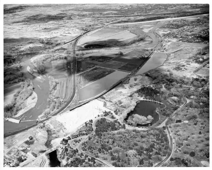
| content | sioc:content | The Colorado State Mental Hospital is located in western Pueblo which has now become an area dominated by modern housing. Originally the vast emptiness surrounding the Hospital made it one of the only discernable features of this area, but now the densely populated area around even makes it difficult to find. The map below shows the campus of the Colorado State Hospital as well as a large unused swathe of land to the north. The constant expansion of the hospital resulted in them quickly using all their available space on their original property. The expansion of the hospital was the chief reason they eventually spread their campus to the north throughout the 40's and 50's. The map above was drawn in 1936 and interestingly does not show that the State Hospital had mad their move to the northern field. Today however, most of the campus that remains in function is located to the north, a few blocks away from the original campus. The split nature of the campus presented some interesting dilemmas for the staff at the hospital. Patients, resources, food, and personnel were constantly being transported between the two sections of the campus, which is separated by about 5 city blocks. Tunnels were eventually built between the campuses that made this easier, though their dark hallways made it possible for patients to hide there for extended periods of time during escape attempts. Today, the tunnels are sealed and unused due to asbestos. The image below is an aerial view of the part of town where the hospital was located and its differences to the modern day landscape are striking. The picture itself was taken in 1960 and is contained in the Pueblo County Library Archives. The hospital and its grounds are located in the upper left side of the image. In stark contrast to todays view, the hospital was surrounded by empty space. |
| default view | scalar:defaultView | image_header |
| was attributed to | prov:wasAttributedTo | https://scalar.usc.edu/works/colorado-state-hospital--1/users/35859 |
| created | dcterms:created | 2022-04-26T08:15:04-07:00 |
| type | rdf:type | http://scalar.usc.edu/2012/01/scalar-ns#Version |
Version 6
| resource | rdf:resource | https://scalar.usc.edu/works/colorado-state-hospital--1/campus-map.6 |
| versionnumber | ov:versionnumber | 6 |
| title | dcterms:title | Campus Map |
| description | dcterms:description | This page discusses maps and images regarding the location of the hospital. |
| content | sioc:content | The Colorado State Mental Hospital is located in western Pueblo which has now become an area dominated by modern housing. Originally the vast emptiness surrounding the Hospital made it one of the only discernable features of this area, but now the densely populated area around even makes it difficult to find. The map below shows the campus of the Colorado State Hospital as well as a large unused swathe of land to the north. The constant expansion of the hospital resulted in them quickly using all their available space on their original property. The expansion of the hospital was the chief reason they eventually spread their campus to the north throughout the 40's and 50's. The map above was drawn in 1936 and interestingly does not show that the State Hospital had mad their move to the northern field. Today however, most of the campus that remains in function is located to the north, a few blocks away from the original campus. The split nature of the campus presented some interesting dilemmas for the staff at the hospital. Patients, resources, food, and personnel were constantly being transported between the two sections of the campus, which is separated by about 5 city blocks. Tunnels were eventually built between the campuses that made this easier, though their dark hallways made it possible for patients to hide there for extended periods of time during escape attempts. Today, the tunnels are sealed and unused due to asbestos. |
| default view | scalar:defaultView | image_header |
| was attributed to | prov:wasAttributedTo | https://scalar.usc.edu/works/colorado-state-hospital--1/users/35859 |
| created | dcterms:created | 2022-04-26T08:11:15-07:00 |
| type | rdf:type | http://scalar.usc.edu/2012/01/scalar-ns#Version |
Version 5
| resource | rdf:resource | https://scalar.usc.edu/works/colorado-state-hospital--1/campus-map.5 |
| versionnumber | ov:versionnumber | 5 |
| title | dcterms:title | Campus Map |
| description | dcterms:description | This page discusses maps and images regarding the location of the hospital. |
| content | sioc:content | The Colorado State Mental Hospital is located in western Pueblo which has now become an area dominated by modern housing. Originally the vast emptiness surrounding the Hospital made it one of the only discernable features of this area, but now the densely populated area around even makes it difficult to find. The map below shows the campus of the Colorado State Hospital as well as a large unused swathe of land to the north. The constant expansion of the hospital resulted in them quickly using all their available space on their original property. The expansion of the hospital was the chief reason they eventually spread their campus to the north throughout the 40's and 50's. The map above was drawn in 1936 and interestingly does not show that the State Hospital had mad their move to the northern field. Today however, most of the campus that remains in function is located to the north, a few blocks away from the original campus. The split nature of the campus presented some interesting dilemmas for the staff at the hospital. Patients, resources, food, and personnel were constantly being transported between the two sections of the campus, which is separated by about 5 city blocks. Tunnels were eventually built between the campuses that made this easier, though their dark hallways made it possible for patients to hide there for extended periods of time during escape attempts. Today, the tunnels are sealed and unused due to asbestos. |
| default view | scalar:defaultView | image_header |
| was attributed to | prov:wasAttributedTo | https://scalar.usc.edu/works/colorado-state-hospital--1/users/35859 |
| created | dcterms:created | 2022-04-26T08:10:21-07:00 |
| type | rdf:type | http://scalar.usc.edu/2012/01/scalar-ns#Version |
Version 4
| resource | rdf:resource | https://scalar.usc.edu/works/colorado-state-hospital--1/campus-map.4 |
| versionnumber | ov:versionnumber | 4 |
| title | dcterms:title | Campus Map |
| description | dcterms:description | This page discusses maps and images regarding the location of the hospital. |
| content | sioc:content | The Colorado State Mental Hospital is located in western Pueblo which has now become an area dominated by modern housing. Originally the vast emptiness surrounding the Hospital made it one of the only discernable features of this area, but now the densely populated area around even makes it difficult to find. The map below shows the campus of the Colorado State Hospital as well as a large unused swathe of land to the north. The constant expansion of the hospital resulted in them quickly using all their available space on their original property. The expansion of the hospital was the chief reason they eventually spread their campus to the north throughout the 40's and 50's. The map above was drawn in 1936 and interestingly does not show that the State Hospital had mad their move to the northern field. Today however, most of the campus that remains in function is located to the north, a few blocks away from the original campus. |
| default view | scalar:defaultView | image_header |
| was attributed to | prov:wasAttributedTo | https://scalar.usc.edu/works/colorado-state-hospital--1/users/35859 |
| created | dcterms:created | 2022-04-26T08:05:24-07:00 |
| type | rdf:type | http://scalar.usc.edu/2012/01/scalar-ns#Version |
Version 3
| resource | rdf:resource | https://scalar.usc.edu/works/colorado-state-hospital--1/campus-map.3 |
| versionnumber | ov:versionnumber | 3 |
| title | dcterms:title | Campus Map |
| description | dcterms:description | This page discusses maps and images regarding the location of the hospital. |
| content | sioc:content | The Colorado State Mental Hospital is located in western Pueblo which has now become an area dominated by modern housing. Originally the vast emptiness surrounding the Hospital made it one of the only discernable features of this area, but now the densely populated area around even makes it difficult to find. The map below shows the campus of the Colorado State Hospital as well as a large unused swathe of land to the north. The constant expansion of the hospital resulted in them quickly using all their available space on their original property. The expansion of the hospital was the chief reason they eventually spread their campus to the north throughout the 40's and 50's. The map above was drawn in 1936 and interestingly does not show that the State Hospital had mad their move to the northern field. Today however, most of the campus that remains in function is located to the north, a few blocks away from the original campus. |
| default view | scalar:defaultView | image_header |
| was attributed to | prov:wasAttributedTo | https://scalar.usc.edu/works/colorado-state-hospital--1/users/35859 |
| created | dcterms:created | 2022-04-26T08:04:27-07:00 |
| type | rdf:type | http://scalar.usc.edu/2012/01/scalar-ns#Version |
Version 2
| resource | rdf:resource | https://scalar.usc.edu/works/colorado-state-hospital--1/campus-map.2 |
| versionnumber | ov:versionnumber | 2 |
| title | dcterms:title | Campus Map |
| description | dcterms:description | This page discusses maps and images regarding the location of the hospital. |
| content | sioc:content | The Colorado State Mental Hospital is located in western Pueblo which has now become an area dominated by modern housing. Originally the vast emptiness surrounding the Hospital made it one of the only discernable features of this area, but now the densely populated area around even makes it difficult to find. The map below shows the campus of the Colorado State Hospital as well as a large unused swathe of land to the north. The constant expansion of the hospital resulted in them quickly using all their available space on their original property. The expansion of the hospital was the chief reason they eventually spread their campus to the north throughout the 40's and 50's. The map above was drawn in 1936 and interestingly does not show that the State Hospital had mad their move to the northern field. Today however, most of the campus that remains in function is located to the north, a few blocks away from the original campus. |
| default view | scalar:defaultView | image_header |
| was attributed to | prov:wasAttributedTo | https://scalar.usc.edu/works/colorado-state-hospital--1/users/35859 |
| created | dcterms:created | 2022-04-26T08:03:59-07:00 |
| type | rdf:type | http://scalar.usc.edu/2012/01/scalar-ns#Version |
Version 1
| resource | rdf:resource | https://scalar.usc.edu/works/colorado-state-hospital--1/campus-map.1 |
| versionnumber | ov:versionnumber | 1 |
| title | dcterms:title | Campus Map |
| default view | scalar:defaultView | plain |
| was attributed to | prov:wasAttributedTo | https://scalar.usc.edu/works/colorado-state-hospital--1/users/35859 |
| created | dcterms:created | 2022-03-15T10:35:17-07:00 |
| type | rdf:type | http://scalar.usc.edu/2012/01/scalar-ns#Version |