Picturing Knowledge: Scientific Images in Printed Books (1450–1800)

Mapping Places, Mapping People

Mapping Places, Mapping People

Claire Fausett, Azriel Czerniak Linder, Hudi Potash, and Eileen Zong

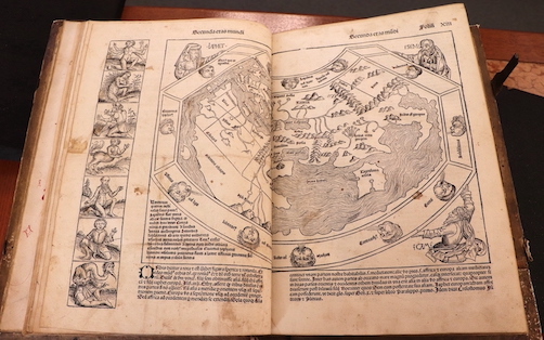
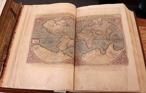
Today, we take maps for granted as factual representations of the world. Yet the very lines delegating borders and names designating places are emblematic of an ongoing process—of political, ethnic, and cultural arguments and changing identities. Maps, like any other source of media, are carefully crafted claims that advance one opinion over another. Where objective geographic measurements and subjective ideological assertions intersect is a gray area—especially when European colonial powers first began charting voyages across the world. As Surekha Davies writes in Renaissance Ethnography and the Invention of the Human, maps were “key artefacts in the fluctuating shape of the human in the European imaginary in an era of transformative, often catastrophic, cultural contacts.”[1] As European explorers encountered new peoples in their voyages, they construed these ethnographic encounters through a framework built on geographic knowledge dating from ancient antiquity. Renaissance books describing Indigenous peoples presented them through subjective, denigrating language that provided justifications for colonial projects. Similarly, our conceptions of race and ethnicity have changed drastically throughout history as a result of European colonization. Race as we understand it today is a human-made social construct for categorizing different social groups according to physical characteristics—it is not a biological fact.[2] Ancient Greek philosophers and Renaissance naturalists believed that human beings were governed by natural laws, and that human bodies varied with climate and geography. More extreme environments were thought to impair peoples’ higher mental faculties and deform their souls. This argument provided the theoretical basis for the expectations of Europeans to encounter monstrous or sub-human peoples during voyages to the Americas.[3] Indeed, the concept of “white people” did not exist until English explorers encountered people of the East Indies. Over time, the concept of whiteness evolved to encompass anyone who looked “European” and contrast against groups that Europeans deemed “savage” or “subhuman”—especially Indigenous and African peoples. By examining Renaissance images portraying voyages and encounters with Indigenous peoples, it becomes clear that we must challenge modern notions of objectivity, whether those are in relation to maps or people.
Case 3: A Changing World

Beginning in 1492, European voyages to the Americas completely upended conceptions of geography and space. Over the following centuries, European maps began to feature larger land areas and regions they had not previously depicted in order to educate and instill wonder among the public. World maps expanded to depict both larger and more finely detailed geographic spaces, and books represented specific locations or regions within the Americas from a Eurocentric viewpoint. Maps and geographic treatises were closely intertwined with the political goals and aims of European empires. (Azriel Czerniak Linder)

Click to see an item.
“World map,” in Hartmann Schedel, Liber Cronicarum [Nuremberg Chronicle] (Nuremberg, 1492)
“Orbis Terrae compendiosa descriptio,” in [Hendrik Hondius], Gerardi Mercatoris Atlas, sive, Cosmographicae meditationes de fabrica mundi et fabricati figura (Amsterdam, 1609)
Both geographically and ethnographically, early modern maps represented a world where information and ideas were constantly changing. During the Renaissance, maps became common tools for scholarly inquiry rather than practical tools meant only for navigation. These maps were not made by explorers, but rather constructed by scholars who used travel accounts to decide what cultural and geographical information to include.[4] Their main purpose was to compare regions and cultures to help readers understand their own kingdoms and Europe as a continent in a worldwide context.[5] Beyond their educational uses, maps were also political tools that asserted the importance of certain places or groups— in almost all cases Europe and Europeans.[6] In his essay titled “Maps, Knowledge, and Power,” historian J.B. Harley stated that “to own the map was to own the land.” Attitudes of superiority were communicated not only through words but through the visual language of maps by adding symbols and illustrations that held cultural meanings that could be readily interpreted and understood by European audiences. The Americas had been represented on world maps beginning in 1507, and these regions grew in prominence as maps continued to be produced.[7] The “new world” depicted on these maps was often presented as if it had never been visited by humans. Groups of Native Americans were often portrayed maliciously and falsely or ignored completely. Silences in maps could have similar effects as the negative and false portrayals of groups.[8] Although the maps were made for the European public, they could only be acquired by a limited audience. They were “expensive, decorative objects made by skilled artisans, they were status symbols that signaled the education and taste of those who commissioned and owned them.”[9] Even for people who were well-off, traveling around the world was dangerous and time consuming, so these maps were presented as safe alternatives to acquiring firsthand knowledge in the manner of explorers.
Case 4: To Travel Is to Map

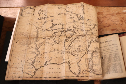
As Europeans explored the Americas, the authority of maps came from travelers’ firsthand observations. In turn, this meant that new maps were highly specific to the contexts and goals of new colonies and settlement efforts. One explorer, Louis Hennepin, traveled to North America with the intention of converting Indigenous people to Christianity. He drew a map of areas he visited with forts, settlements, ports, and other key locations and indicated the navigation routes linking these sites. Later observers noted that the Mississippi River was misrepresented in Hennepin’s map, showing that the act of mapping was a continuous and iterative project for cartographers. (Hudi Potash)

Click to see an item.
“A Map of a Large Country Newly Discovered,” in Louis Hennepin, A new discovery of a vast country in America ... (London, 1699)
As Europeans began to expand their spatial understanding of the world, they revised their maps to include these newly “discovered” lands. Mapping itself was not unknown to Europeans before 1493, as one of the most historically significant incunable books included a world map. The map in this book had only three continents: Europe, Asia, and Africa.[10] But as Europeans began to realize there were vast continents not included in their prior worldviews, they began to draw and map these areas using existing European norms for cartography. These conventions were a “form of political discourse concerned with the acquisition of power.”[11] These norms included placing Europe centrally and at the tops of maps, which gave the continent visual priority. Mercator's map was one of the most recognized world maps and showed three other continents: the Americas and Oceania.[12] Mercator's grid lines confer a sense of objectivity to this map in comparison with prior world maps. Yet these maps nevertheless expressed the opinions and claims to power of their creators and played a role in forming “imaginary communities” among European publics.[13] Ultimately, questions about who decides or controls the ownership of land are not objective. Mercator himself never visited the lands shown in his maps; rather, his authority came from communicating with explorers and aggregating the information they provided.[14] Of course, he neglected Indigenous perspectives. As time went on, explorers themselves began to map the areas they visited. For example, a missionary, Louis Hennepin, described his voyages in North America in A new discovery of a vast country in America… (London, 1699). The book included his map dedicated to King William III of England in 1699. This map included specific features like forts and Indigenous villages.[15] These details show that mapping practices became more focused on the features of specific regions. “A Changing World” and “To Travel is to Map” focus on the changes in cartography as Europeans began to voyage beyond their continent. These maps were integral to defining and expanding the knowledge of natural history and science. While Europeans may have viewed these maps as “objective,” maps resulted from human choices, partial understandings of the spaces they represented, and ideological claims about the right to control the ownership of land.[16] If owning land is a form of power, then the choices made by cartographers while drawing space helped to support their claims about the proper ownership of land and wealth in the Americas.
Case 5: Ethnographic Encounters

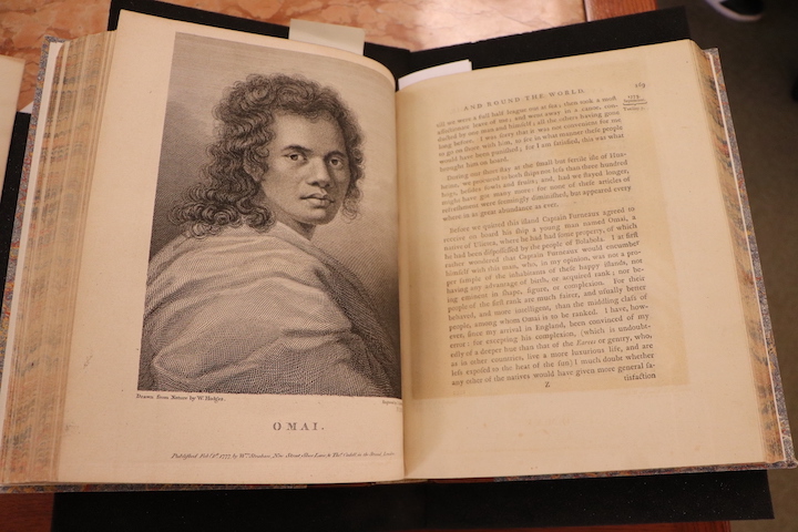
English colonial voyages to Australia, the Pacific Islands, and the Americas set in motion impactful and culturally destructive encounters that contributed to the development of the British Empire. Captain James Cook’s published account of his voyages urged Britain to reap “the full advantages of her own discoveries.” The maritime charts included in Cook’s publications would later become essential for British settlement of Australia and New Zealand. Similarly, James Adair wrote in the dedication to his book that he hoped to “promote an accurate investigation and knowledge of the American Indians . . . and the happy settlement of the fertile lands around them.” (Claire Fausett and Eileen Zong)

Click to see an item.
“A Map of the American Indian Nations,” in James Adair, The History of the American Indians: Particularly those Nations Adjoining to the Mississippi, East and West Florida, Georgia, South and North Carolina, and Virginia ... (London, 1775)
“Omai, who was brought to England by Captain Furneaux,” in James Cook, A Voyage Towards the South Pole and Round the World: Performed in His Majesty’s Ships the Resolution and Adventure, in the Years 1772, 1773, 1774 and 1775 (London, 1777)
When Europeans started adventuring into new parts of the world, they encountered indigenous peoples with different customs and ways of life. European explorers applied arbitrary Western standards regarding what made a civilized culture and decided that the Indigenous people globally were inferior to them. New explorers, who followed in the footsteps of the first wave of early discoverers, continued these misconceptions by applying established derogatory stereotypes to the Indigenous Peoples they encountered. Maps and books about voyages were crucial to developing the European mindset towards Indigenous people, as travel was inaccessible during this time.[17] Hence, people relied on books to learn the truth about other parts of the globe. Early Modern ethnography misrepresented the indigenous groups that explorers encountered and often simplified them into one caricature found on the corner of an artist's map. Placing one small ethnographic image on a map to represent a non-European part of the world gave the map's readers an easy way of understanding the civility and culture of a people.[18] Renaissance writers worked diligently in their books to establish authority in their depictions and convince the public to believe their ideas about a region they had never seen before. “Ethnographic Encounters” picks up in the 1700s, following around two hundred years of European conquest and encounters with indigenous peoples globally. This case will examine how harmful rhetoric fostered by map makers enabled the attitude towards indigenous peoples by the end of the Early Modern age. Following hundreds of years of map makers establishing harmful stereotypes through ethnographic images on maps, newer maps did not need to be ethnographic. Instead, most books from the late years of the Early Modern era prioritized ethnographic research (which we can think of similarly to anthropological research), detailing the customs and beliefs of the indigenous peoples. In The history of the American Indians, James Adair introduces his map at the start of the book to allow readers to locate the specific groups he mentions as they read. Adair notably introduces previous stereotypes as strong themes in his depictions of indigenous peoples.[19] Captain James Cook's rhetoric in A voyage towards the South Pole and round the world exemplifies how ingrained stereotypes created on ethnographic maps became and how it shaped Cooks plans for his voyage.[20] Therefore, "Ethnographic Encounters" focuses on the impact of previous scholarship on Indigenous peoples found on ethnographic maps and the new age of ethnographic research during the eighteenth century.


[1] Surekha Davies, Renaissance Ethnography and the Invention of the Human: New Worlds, Maps, and Monsters (Cambridge: Cambridge University Press, 2016), 2.

[2] "Historical Foundations of Race." National Museum of African American History and Culture. Accessed October 30, 2022. https://nmaahc.si.edu/learn/talking-about-race/topics/historical-foundations-race

[3] Davies, Renaissance Ethnography, 2.

[4] Davies, Renaissance Ethnography, 1–2.

[5] Davies, Renaissance Ethnography, 47.

[6] Davies, Renaissance Ethnography,60.

[7] Davies, Renaissance Ethnography, 88.

[8] J.B. Harley, "Maps, Knowledge, and Power," in Paul Laxter (ed.), The New Nature of Maps: Essays on the History of Cartography (Baltimore: The Johns Hopkins University Press, 2001), 67.

[9] Davies, Renaissance Ethnography, 115.

[10] "World map," woodcut, in Hartmann Schedel, Liber Cronicarum [Nuremberg Chronicle] (Nuremberg, 1492)

[11] David Turnbull, "Cartography and Science in Early Modern Europe: Mapping the Construction of Knowledge Spaces," Imago Mundi 48, no. 1 (1996): 5-24.

[12] Keith Hodgkinson, "Standing the World on its Head: A Review of Eurocentrism in Humanities Maps and Atlases," Teaching History 62, (1991): 19.

[13] Davies, Renaissance Ethnography, 4.

[14] “Mercator’s Atlas of Europe,” The British Library, https://www.bl.uk/collection-items/mercator-atlas-of-europe, accessed November 2, 2022 .

[15] “A Map of a Large Country Newly Discovered," copperplate engraving, in Louis Hennepin, A new discovery of a vast country in America…,(London, 1699)

[16] Graham Huggan, “Decolonizing the Map: Postcolonialism, Poststructuralism and the Cartographic Connection,” in Graham Huggan (ed. ), Interdisciplinary Measures: Literature and the Future of Postcolonial Studies (Liverpool: Liverpool University Press, 2008), 67.

[17] Davies, Renaissance Ethnography, 2.

[18] Davies, Renaissance Ethnography, 10.

[19] James Adair, The History of the American Indians;: Particularly Those Nations Adjoining to the Mississippi, East and West Florida, Georgia, South and North Carolina, and Virginia:... (London, 1775).

[20] James Cook, A Voyage towards the South Pole and Round the World (London, 1777).

Contents of this path: