Mapping Asia Adjacent to the United States
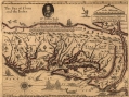
Likewise, English promoters of American colonization desperately hoped to find Asia close by, or at least just beyond a direct water route across a minor continent, the infamous, elusive Northwest Passage. In 1651 English mapmaker and member of the Royal Virginia Company, John Farrer, sent home a promotional map mistaking the mountain chain along the east coast of California, the Sierra Madres, described by Francis Drake (whose portrait is displayed on the map for reference), for the Appalachian Mountains bordering the western reaches of the explored parts of Virginia (note that west lies along the top of the map). The map is, in fact, accurate as far north as the Delaware River, but then veers into imaginary geography in depicting the Hudson as running a short path directly into the Sea of China. A legend on the map notes that it is only a ten-day march from the head of the James River to the rivers that run into the "Indian Seas."[22]
________________________
[22] Jeremy O' Connor and Michael DiRuggiero, Collectorsfolio, New Your, NY, accessed online on 9/20/14, http://www.collectorsfolio.com/rare-books/86/231/farrar-farrer-john-a-mapp-of-virginia-discouered-to-ye-hills-first-edition