Circulation and Centrality: Networks of Motion from Footpath to Freeway to Flight Path, 9,000 BP to the 21st Century
So much is true of all cities. But every city grows up defining utterly unique places, utterly unique regions, and those urban places embody, produce, and transmit the diversity of the world: Everyone wants Paris, London, Mumbai, Shanghai, San Francisco, and Los Angels to be different, unique places. Ghost Metropolis seeks to map the ultimately unique ways that Los Angeles put its distinctive stamp on the world. The world put its stamp on Los Angeles as well, to be sure. Especially since the Spanish conquered it as an imperial outpost, the flow of global civilization into and out of Los Angeles has been one of its most defining features.
Just how people, things, ideas circulate between and within cities is a matter of supreme importance for understanding any place. Circulatory networks etch the paths of intensive human labor at the scale of minutes, hours, days, months, and years. At the scale of generations and centuries, early paths become major highways and arteries. People and their institutions take root around those paths and the central places where they intersect.
Foot and Wheel Roads
The shape of Los Angeles today reflects the shapes inscribed over many centuries by many generations. The 110 Harbor Freeway, constructed 1948-1953, follows the path of a road that was already thousands of years old when the Spanish arrived. That path, about 23 miles in length, is labeled "Very Ancient Road" in Kirkman and Harriman's 1937 reconstruction of historic thoroughfares in the Los Angeles Basin. (See Detail of 1937 map). style="line-height: 20.8px;" Millingstone People inhabited the Los Angeles Basin for about 9,000 years, followed by another 2,000 years of Uto-Aztecan rule before the Spanish arrived. The LA Basin was highly inscribed by these centuries of circulation between the principal Southern California settlements, threading through canyons, along rivers and ridges, between hills, and through passes like the later-named Sepulveda Pass. Spanish conquerors most certainly used these footways as the basis for their horse-and-cart-carrying "Caminos Reales" ("Royal Roads"--that is, official roads of the Spanish Empire) and "Mission Roads" (that is, road that connected the Roman Catholic missions run by the Franciscan order) Those roads, in turn were paved and graded during the Anglo period for the Age of the Automobile. Fast forward to the mid-Twentieth century, and witness that the Caminos Reales of the Los Angeles Basin provided the paths for the Ventura (US 101) Hollywood (101), and San Diego Freeways (5) Freeways. Those join with the rest of the renowned LA freeway network in a tight ring around the original Spanish Land Grant of "Four Square Leagues" centered on La Placita.. This centrality has always assured that the highest densities of land value, highest concentrations of financial capital, highest traffic flow densities, and highest concentrations of state officers (Federal, California, County, and Los Angeles City governments), are co-located here.Note
This ever-growing network of arteries historically converged on a very durable core: "Yang-na" (Indigenous), "El Pueblo..." (Spanish/Mexican), "Downtown LA" (Anglo). This circulatory network converged on that core many centuries prior to the end of the 18th century, when the Spanish empire represented by the fourth Gubernador de Alta California, Felipe de Neve (1724–1784; governor 1775-1782) chose that site for its Pueblo in 1781. The centrality of Downtown LA today derives its power from this deep historical inscription.Note
Prior to the high-speed "freeways" of the mid-20th century, the "highways," prior to the 1950s were mainly the multi-lane paved arteries: Figueroa, Pico, Santa Monica, Long Beach, Alameda, Whittier, Wilshire, Mission, San Fernando, Manchester, and many more. Regional maps from 1910-20s show the footprint of the Spanish-Mexican period in meandering mission roads and caminos reales roads that connected the ancient dense settlements along the canyons and basins of the region, most certainly etched into pre-existing indigenous Uto-Aztecan paths.
Gridded over this ancient network of place-connecting "Old Roads," (as Kirkman and Harriman called them in their 1937 reconstruction) are the half-square mile Anglo arterials. The grid in urban planning is doubly neoclassical in Los Angeles: from the Spanish Law of the Indies, and from Jefferson's Enlightenment/capitalist Northwest Ordinance. The Anglo-American grid is one that does not always connect pre-existing settlements, in the way that ancient roadways do. In capitalist urbanism, the value polarity is reversed: the roadway is the valuable spatial form, conferring value on the land as a commodity. Nineteenth-century American city governments served as subsidizers of private investors and developers. Thus, the initial (post-1848) Anglo grid of rectilinear North-South and East-West arteries originally appeared preposterous. Graded with space for 8 traffic lanes (sufficient in the 21st century to carry up to 300,000 vehicles per day), these giant roads in the 1880s looked like a gratuitous dredging of the pastoral landscape.
Together, the ancient and the Anglo highways convered on two centers: the old Spanish-Mexican Plaza (known for generations as "La Placita"), and the newer Anglo-Commercial "Downtown," centered at Central Park (later renamed Pershing Square). For many years, automotive and horse-drawn vehicles jostled side-by-side. Already by 1915, the Auto Club of Southern California printed a map of LA's Downtown "Congested District," showing the effect of so much traffic converging at this central place, within the 1781 Royal Grant of four square leagues.
Standing back to view the region asa whole, fold-out map produced by the Auto Club also in 1915 shows how automobile-carrying old roads (Mission, San Fernando) plus the major Anglo arteries linked more than twenty urban concentrations throughout Southern California, all converging on Downtown LA. These two Auto Club maps help to explain each other: the congestion at the center reflected the bottle-neck of so many arteries converging there. That center, in turn, hosted the administrative centers that organized communication, investment, power, and the wider distribution of goods throughout the region.
Rail Roads
It is often thought that the Age of Automobile succeeded the great Age of Railroad, but in fact as mass people movers, they overlapped from about 1900 to 1940, and served different purposes. Automobiles were limited to local, metropolitan, and regional and travel, while Railroads provided most inter-state and inter-regional travel, and "light rail" (trolleys, streetcars) provided about the same range as automobiles.
Railroads (meaning inter-urban here) and ocean-going passenger ships hauled most of the millions of people entering and exiting the Southern California Region annually by the beginning of the 20th century. Roads outside of most major cities in the United States were still very difficult for automobiles to traverse. Besides, Los Angeles is ringed by deserts and high mountain chains, so only the adventurous would have attempted long-distance auto travel to Los Angeles before the 1920s. The two principal rail lines into and out of Los Angeles after the 1880s were the Southern Pacific and the Santa Fe. Each had its own Downtown terminal.
The Southern Pacific's central Downtown terminus depot migrated several times as its flow increased. The first location was the River Station, (two successive structures, 1876-88, 1888-1901) in what is today known as the Cornfields, a space north of New Chinatown next to the Los Angeles River. The SP upgraded their facilities with the Arcade Station, from 1888 until 1914. The Arcade was replaced again by the Beaux Arts Central Depot, which opened in 1918.
The Santa Fe Railroad's "La Grande" railway station between 1st and 2nd Streets on Santa Fe Ave, adjacent to the Los Angeles River, was for three generations the second major railway gateway into and out of Los Angeles. Built in 1893, the same year as the Bradbury Building, it's architects gave its central open chamber a "Moorish" dome and the rest of it a medieval Crusader's castle. For 44 years, from its opening in 1893 until it was closed in 1938, millions of people flowed into and out of this shared space.
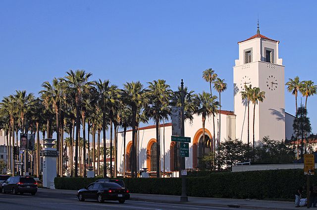
Having two major transcontinental railroads converge on Downtown at two separate major railway became a serious burden by the end of the booming 1920s, during which decade tens of millions arrived by rail as the permanent population of Los Angeles grew by two million residents. Siting and building a major unified (that is "Union"") passenger station, linking all the intercontinental, regional, and local rail systems, became a major public choice on the ballot in 1926. The location was a master-stroke of the Los Angeles elite's racial and spatial imagination. The "Arroyo Set" of Romantic civic leaders wished through urban planning to focus public attention on the now-quaint Olvera Street, and on the Plaza (now as a Yankee-supervised fiesta space to supercede its role in the 19-teens as a revolutionary mass-meeting space). That and the sensible goal of siting a Union Station on Alameda St as a central thoroughfare argued for the parcel on the east side of Alameda just opposite Olvera St and La Placita.
The planned Union Station site, however, was currently occupied, by (Old) Chinatown. That was no accident either. While Christine Sterling (mastermind of Olvera Street as a tourist attraction and branding landscape for Los Angeles) idolized a "Spanish" (erasing the public figure of the darker-skinned indigenous Mexicans and mixed-race "cholos" of the large Angeleno Mexican working class), the Otis-Chandler oligarchy had long wished to eradicate the whole of Chinatown. Union Station, designed by architects John Parkinson and Donald B. Parkinson in a Spanish style to match the now-romanticized Missions, killed both birds with one structure.
Shrewdly bargaining with Chinatown's civic/business leaders to establish a "New" Chinatown several blocks to the North, on the much more pleasant and higher ground of Broadway north of Sunset, the Union Station planners eventually razed more than ten dense city blocks of (Old) Chinatown to build what would prove to be the last great metropolitan passenger rail station in the United States.
Union Station arrived in 1939 just in time for the Age of the Automobile. while that accolade makes it sound like it became obsolete, the story is not so simple nor even true. While rail ridership did steadily decline from the 1950s until the 1980s, the regional Metropolitan Transit Authority (MTA) eventually breathed new life into Union Station by expanding it to become the hub of the entire late-20th century public rail system, providing ideal transfers between intercontinental, inter-urban, and urban streetcar systems.
Angelenos and visitors to Los Angeles during the years from the 1890s to the 1940s navigated a diverse landscape of multiple transportation modes. The great wide-gauge Santa Fe and Southern Pacific passenger railways brought the masses into and out of the metropolis, but "light rail," both inter-urban and intra-urban lines, criss-crossed the region, branching outward from the central node of Downtown LA. The most renowned is the gigantic Pacific Electric Railway, a business venture and simmering hotbed of labor strikes from its inception in 1901, though its peak in the 1920s-30s, until its demise in 1961.
Running, at its peak, 2,160 daily trains over 1,000 miles (1,600 km) of track at its peak coverage in the 1920s, the "PE Red Cars" provided reliable and affordable regional transformation. It was reputedly the largest inter-urban mass transit system int eh world. Capitalized by the SP heir Collis P. Huntington and the banker I.W. Hellman, the actual purpose of their mass transit system was to endow market value on the vast tracts of Los Angeles Basin land that they sought to develop as residential communities. While it was a marvel of clean, efficient, and affordable public transit (privately held), the Red Cars were essentially a "Free Lunch." That very term, "free lunch," was coined by Southern California real estate developers, who offered free lunches on weekends as part of picnic marketing events to sell plots on the wind-swept subdivisions that defined "suburbia" in the San Fernando and San Gabriel Valleys, especially. predictably, then, Huntington and Hellman lost interest in the Pacific Electric once they had sold off and developed the bulk of their holdings by the late 1930s, and gladly sold it off, just when its service began to sag, with very slow travel times and fewer open lines.
Thanks to a long-lived folk legend, many think that they know about the the disappearance of the Red Cars and mass rail by the 1960s, General Motors and the petroleum industry, it is alleged, bought up and tore-up the PE tracks to favor rubber-wheeled, gas-guzzling buses and automobiles. GM did indeed, buy up and tear-up much of those lines. But few people rode the Red Cars by the 1950s. The Pacific Electric was built "at grade," meaning, it had to share streets and intersections with automobiles, trucks, and buses. That cheap-build arrangement was fine in the 1920s, for the original purpose of providing access to far-flung suburban real estate developments by Huntington and Hellman.
By the late 1940s and the 1950s so many vehicles crowded the Los Angeles Basin that PE Red Car riders spent frustrating hours in traffic jams. The two transportation modes were already strained by congestion by the mid-1930s, when the State Highway Department conducted a systematic traffic density survey, and produced an excellent map-visualization of traffic flow in the Los Angeles metropolis. Reading this map in detail, following a very clear legend, we can see which stretches of the major arteries experienced the highest vehicle volume per day. The maximum in 1934 was 21,000-40,000 per day. At the peak zones surveyors counted 20-40,000 vehicles per day (approx 2,000 per hour): Mid-Wilshire west of downtown; Figueroa approaching north and south of Downtown, Sunset Boulevard and Brooklyn Ave (today Cesar Chavez Ave); Ventura Blvd in the San Fernando Valley.
These areas are of great interest because they point directly to the zones of greatest circulatory activity, which in urban economics, translates directly into highest land values (called "ground rent" by economists). This intensive circulation inscribed central place power into the metropolitan landscape. These same areas are among the highest traffic densities and land values in the 21st century.
The historian Scott Bottles showed long ago, no GM-led conspiracy was even necessary to kill mass transit. Ironically, the masses who bought and drove automobiles, not the industry leaders who profited from them, killed light rail by abandoning them for cars that then crowded the streets so much that the Red Cars, like 1920s relics, could barely move. Besides, a 1,000-mile streetcar system depend for its construction, operation, and maintenance on an army of thousands of workers, and those workers were rarely happy with their pay or conditions, striking regularly during life of the Pacific Electric Railway (especially in 1903, 1918, and **). Declining ridership and chronic labor rebellion soured any investor's interest in the famed light-rail system by the late 1950s, and the last line closed in 1961.
This page has paths:
- structured media gallery test Curtis Fletcher
- Places and Paths of Los Angeles Phil Ethington
- Narrative Essays Phil Ethington
This page references:
- "The Santa Fe Station By Night, Los Angeles, Cal." [A nighttime view of the La Grande Station from the southeast].
- The Southern California Region in 1915
- Southern Pacific "Arcade Station" Alameda St at 5th St (1891)
- Relief map of territory served by lines of [the] Pacific Electric Railway in Southern California (1920)
- Southern Pacific's River Station 1887−1901
- The Four-Level Interchange, 1954
- Legend, Traffic Density: California Highway Transportation Survey, 1934.
- Model of Downtown LA, Showing Union Station (model and photo, 1938. Union Station opened 1939).
- Old Roads, Harbors, and Freeways, 10,000 BCE to 2000
- Map Showing Congested and Business District of the City of Los Angeles and Corners Where Left Turns Are Prohbited
- Detail: Central Area., Traffic Density, 1934, State Department of Highways
- Marchessault St. during evacuation of Old Chinatown prior to razing, 1933
- Pacific Electric Railway, 1901-1961
- Pacific Electric Red Car (2008)
- Union Station (1939), Alamada St, Los Angeles
- Detail showing "Very Ancient Road" in Kirkman and Harriman Map (1937)