Soil
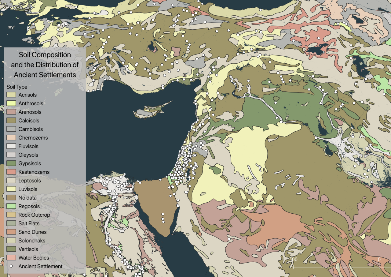
Soil composition features prominently in Scott’s work: “We can be more specific about the geographical conditions for state building. Only the richest soils were productive enough per hectare to sustain a large population in a compact area and to produce a taxable surplus. In practice this meant loess (wind deposited) or alluvial (flood deposited) soils. Alluvia, the historic gift of the annual floods of the Tigris and Euphrates and their tributaries, were the sites of state making in Mesopotamia: no alluvium, no state.”1 Scott’s comments allude to the interconnection of environmental variables in creating as well as maintaining the conditions necessary for agriculture to take support large settled populations. Further, the identification of loess or alluvial soil deposits highlights the specificity of the “recipe” for agriculturally ideal landscapes. Figure 4 compares the ancient settlement dataset from Figure 3 with soil composition data, aggregated from modern sources and made available by the FAO in the Harmonized World Soil Database (HWSD).2
The visual cacophony of information presented in this sample region reveals the complex distribution of soil types across globe. Table 1 clarifies the relationship between the ancient settlement data (see Figure 3) used in this chapter (not globally comprehensive, but inclusive of the regions with which this dissertation is concerned) and the HWSD soil composition dataset.3 Although it is important to recall the unreliability of the georeferenced ancient settlement data at scales small enough to require precise coordinates, the information contained within Table 1 lends credence to Scott’s suggestion that wind- or water-deposited soils account for the majority of land on which agricultural settlements were founded. Comparing the modern cities dataset (see Figure 2) with the HWSD soil data, Table 2 confirms many of the associations between soil types and settled agricultural centers suggested in Table 1.4
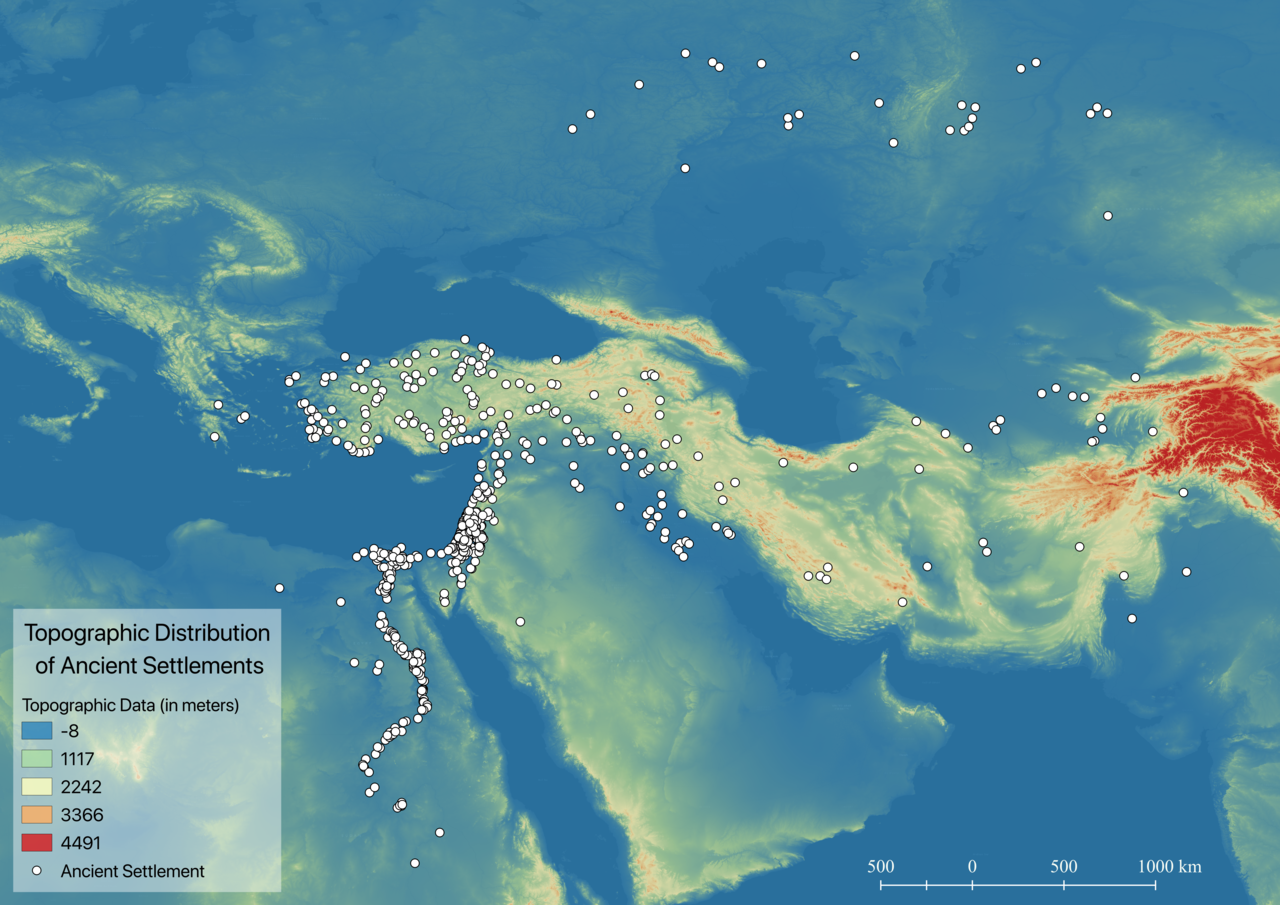
According to the FAO’s World Reference Base for Soil Resources 2014, the soil types “Calcisols,” “Fluvisols,” “Luvisols,” and some “Cambisols” appear to fit the descriptions of deposited material used by Scott (loess or alluvial).5 Together these soil types are associated with just over half of the ancient settlements in the dataset and account for approximately 550 million hectares of global land surface.6 The same volume describes the soil type “Leptosols” as the most extensive (1.655 billion ha) comprising thin layers of soil predominately found in mountainous regions.7 The large number of settlements found within this group of soils suggest the need for an examination of the potential role of topography in the development of agriculture. The relationship between topography and the ancient settlement dataset (Figure 5) appears to be inconsistent enough to discount this feature as a major variable in the definition of agriculturally ideal landscapes.8 Although a direct role of topographic variation in the environmental “recipe” for agricultural settlement is not indicated in Figure 5, the shape of physical landscapes significantly does seem to affect the distribution of weather, surface water, and soil deposits.
1 Scott, Against the Grain: A Deep History of the Earliest States, 124.
2 Data from: “Harmonized World Soil Database v1.2 | FAO SOILS PORTAL | Food and Agriculture Organization of the United Nations,” accessed November 17, 2018, http://www.fao.org/soils-portal/soil-survey/soil-maps-and-databases/harmonized-world-soil-database-v12/en/; G. Fischer et al., “Global Agro-Ecological Zones Assessment for Agriculture (GAEZ 2008). IIASA, Laxenburg, Austria and FAO, Rome, Italy.,” 2008.
3 In order to conserve space, Table 1 includes only the soil types associated with a minimum of one percent of ancient settlement data.
4 In order to conserve space, Table 2 includes only the soil types associated with a minimum of five percent of modern city data.
5 IUSS Working Group WRB, World Reference Base for Soil Resources 2014, Update 2015 International Soil Classification System for Naming Soils and Creating Legends for Soil Maps, World Soil Resources Reports 106 (Rome: FAO, 2015), 151–52, 157–58, 165–66.
6 IUSS Working Group WRB, 151, 158, 167.
7 IUSS Working Group WRB, 163–64.
8 Data from: “Global Multi-Resolution Terrain Elevation Data 2010 (GMTED2010),” accessed November 1, 2018, https://topotools.cr.usgs.gov/gmted_viewer/.
This page has paths:
- Agriculturally Marginal Landscapes Edward N. Surman