Settled Agricultural "Civilization"
Figure 1 presents one such dataset, “Cradles of Civilization,” georeferenced from Figure “2.1. Locations of seven early civilizations” in Bruce G. Trigger’s Understanding Early Civilizations.1 Trigger writes,
This study compares seven early civilizations that developed in different parts of the world: Old and Middle Kingdom Egypt (2700–1780 B.C.), southern Mesopotamia from Early Dynastic III to Old Babylonian times (2500– 1600 B.C.), northern China in the late Shang and early Western Zhou periods (1200–950 B.C.), the Valley of Mexico in the late fifteenth and early sixteenth centuries A.D., the Classic Maya (A.D. 250–800), the Inka kingdom during the early sixteenth century A.D., and the Yoruba and Benin peoples of West Africa from the mid-eighteenth century to the beginning of the colonial era in the late nineteenth century (Figs. 2.1, 2.2). The Yoruba states and Benin, selected to represent sub-Saharan Africa, constituted the best-documented and one of the culturally most advanced early civilizations of that region. The same is true of the Late Aztec period in the Valley of Mexico in the broader context of highland Mesoamerica, of the Inka kingdom in the context of Peru, of the Shang state in relation to all of China, and of southern Mesopotamia in relation to the Middle East. Ancient Egypt and the Classic Maya were the sole early civilizations that developed in their particular areas.2
In Figure 1, this information is juxtaposed with modern agricultural land cover data produced using an algorithm for interpreting global satellite imagery.3 Navin Ramankutty et al. explain,
The agricultural inventory data, with much greater spatial detail than previously available, is used to train a land cover classification data set obtained by merging two different satellite-derived products (Boston University’s MODIS-derived land cover product and the GLC2000 data set). Our data are presented at 5 min (10 km) spatial resolution in longitude by longitude, have greater accuracy than previously available, and for the first time include statistical confidence intervals on the estimates. According to the data, there were 15.0 (90% confidence range of 12.2–17.1) million km of cropland (12% of the Earth’s ice-free land surface) and 28.0 90% confidence range of 23.6–30.0) million km of pasture (22%) in the year 2000.4
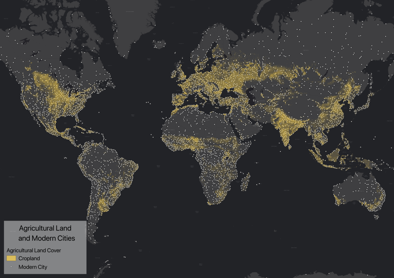
This figure suggests a relationship between modern and ancient regions of agricultural settlement. The connection between settlement and agriculture is further emphasized in Figure 2, which layers the same agricultural land cover dataset with information regarding modern population centers.5
The same cropland data is compared with ancient settlement information georeferenced from volumes on the archaeology and history of the ancient Near East, Middle East, and Central Asia in Figure 3.6 At a regional scale, the relationship between modern agricultural land cover and ancient settlement data is particularly striking.
In Against the Grain, James C. Scott argues that the connection between agriculture and settled “civilization” is notably pronounced in grain-based farming cultures.7 He writes, “In a grain state, one or two cereal grains provided the main food starch, the unit of taxation in kind, and the basis for a hegemonic agrarian calendar. Such states were confined to the ecological niches where alluvial soils and available water made them possible….The key to the nexus between grains and states lies, I believe, in the fact that only the cereal grains can serve as a basis for taxation: visible, divisible, assessable, storable, transportable, and ‘rationable.'”8 Scott’s suggestion provides a reasonable explanation for the apparent stability of a relationship between settled states and agricultural modes of food production (of a particular category of crops). Although they are not grouped according to state or political affiliation, the ancient settlements shown in Figure 3 seem to distribute along the general shapes of large polities (states and empires) known in the region before the Common Era (the largest and longest-lived are identifiable in Figure 1, georeferenced from Trigger’s work). This connection is useful to identifying the category of environmental zone that contextualizes the earliest settled agricultural societies.
The category of landscape not “agriculturally marginal” might be called “agriculturally ideal.” Scott notes that states, being predominately agrarian, were geographically limited by the environmental needs of agriculture until the modern era.9 Figure 1 offers a glimpse of the limited extent agricultural land cover in recent decades and suggests that the majority of global land mass does not seem to be used for farming. The small and scattered zones which gave rise to “cradles” of agricultural settlement identified in this figure point to the reality that large-scale agriculture (particularly those “grain-based” economies on which Scott bases his research) has been historically possible in a small percentage of the land in the world. According to the Food and Agriculture Organization of the United Nations (FAO), just less than one third (4.17 billion hectares) of the land surface of the globe (13.4 billion ha) is, to varying degrees, potentially suitable for agricultural production.10 This number far outstrips what the FAO estimates is the actual global extent of cropland by the early 21stcentury: approximately 1.5 billion ha (just over a third of the estimated potential).11 In numeric terms, it appears that the vast majority of the global land surface area falls within the category of agriculturally marginal landscapes. In order to understand the environmental features of agriculturally ideal landscapes that set this category apart from agriculturally marginal landscapes this examination includes environmental data comprising the most basic “recipe” for farming: soil, water, and sunlight.
1 Bruce G. Trigger, Understanding Early Civilizations: A Comparative Study (Cambridge: Cambridge University Press, 2003), 31.
2 Trigger, 28.
3 Cropland data from: “Cropland and Pasture Area in 2000,” EarthStat, accessed November 16, 2018, http://www.earthstat.org/cropland-pasture-area-2000/; Navin Ramankutty et al., “Farming the Planet: 1. Geographic Distribution of Global Agricultural Lands in the Year 2000,” Global Biogeochemical Cycles 22, no. 1 (March 1, 2008), https://doi.org/10.1029/2007GB002952; Navin Ramankutty and Jonathan A. Foley, “Estimating Historical Changes in Land Cover: North American Croplands from 1850 to 1992,” Global Ecology and Biogeography 8, no. 5 (1999): 381–96.
4 Ramankutty et al., “Farming the Planet: 1. Geographic Distribution of Global Agricultural Lands in the Year 2000.”
5 Data from Natural Earth: “Populated Places | Natural Earth,” accessed November 16, 2018, https://www.naturalearthdata.com/downloads/10m-cultural-vectors/10m-populated-places/.
6 Data georeferenced from maps found within: Anthony, The Horse, the Wheel, and Language: How Bronze-Age Riders from the Eurasian Steppes Shaped the Modern World, 390, 414; William G. Dever, Beyond the Texts: An Archaeological Portrait of Ancient Israel and Judah (Atlanta: SBL Press, 2017), 265, 396; Kuhrt, The Ancient Near East c. 3000-330 BC, 2006, 1:57, 83, 131, 233, 319, 366; Kuhrt, The Ancient Near East c. 3000-330 BC, 2006, 2:549, 563, 627, 635; Kuhrt, The Persian Empire, 2007, 1:190–91; Amihai Mazar, Archaeology of the Land of the Bible, 1st ed., The Anchor Bible Reference Library (New York: Doubleday, 1990), 61, 95, 115, 153, 177, 309, 370; Richard H. Wilkinson, The Complete Temples of Ancient Egypt (New York: Thames & Hudson, 2000), 10–11 Only one data point is mapped per settlement, regardless of how many times it is attested in these sources.
7 James C. Scott, Against the Grain: A Deep History of the Earliest States, Yale Agrarian Studies (New Haven: Yale University Press, 2017), 128.
8 Scott, 128–29.
9 Scott, 14.
10 “World Agriculture: Towards 2015/2030 - An FAO Perspective,” accessed November 19, 2018, http://www.fao.org/docrep/005/y4252e/y4252e06.htm.
11 “World Agriculture: Towards 2015/2030 - An FAO Perspective.”
This page has paths:
- Agriculturally Marginal Landscapes Edward N. Surman