Pushpita's Project Review
Project Name: Mapping gothic.org
Mapping Gothic France is an informative web archive of France in gothic period. The Mapping Gothic France project was initiated by Stephen Murray, Professor of Art History and Archaeology at Columbia University and Andrew Tallon, Assistant Professor of Art at Vassar College and funded through the Andrew W. Mellon Foundation. Mapping Gothic France was developed within the framework of collaboration between the Media Center for Art History in the Department of Art History and Archaeology at Columbia University, the Visual Resources Library at Vassar College, and the Columbia University Libraries.It is an open source project. With a database of images, texts, charts and historical maps, Mapping Gothic France invites its reader to explore the parallel stories of Gothic architecture and the formation of France in the 12th and 13th centuries, considered in three dimensions: space, time and narratives. The project is designed is such a way so that its reader can easily get the experience of both academic and aesthetic excellence. Along with the virtual tour of the monuments, this site includes the essays, historical documentations and mapping, detail architectural and structural description of these churches along with their history. Moreover this project went beyond only archiving by providing simulation software for virtual modeling to analyze the projects, which directly a try to merge the first and second wave of digital humanities.
The design of the journal is accomplished with great intensity. It is a complete blend of literary work with visualization. It is basically the listing of the gothic churches throughout Europe, especially in France. This digital humanities project includes all the Gothic churches in the digital mapping by data mining system and also provided the detail description of those churches. This site is all together much informative as well as has a great deal of visual aesthetic.
Their intention was not just to develop a more appropriate way of representing the spaciousness of individual monuments, but to provide the user of the site with new ways to understand the relationship of hundreds of buildings conventionally described as "Gothic" -- in terms of sameness and difference, found in the forms of multiple buildings within a defined period of time and space that corresponds to the advent of the nation of France. With documenting the detailing of the church, this project gave a clear understanding of the time period of the particular monument, the socio political strata of Europe, the political control of France on European countries through mapping. It is not a pile of information, but surely is a resourceful source of information. The resources are very easy to navigate and at the same time it has an effective and clear functionality for its readers. It combines the functionality of traditional print media to the advanced digital technologies like 360 degree panoramic view of a monument, the juxtaposition of maps with images, the virtual tour of the monument sites etc. which traditional system of archiving could never achieve. Therefore this project is a well try to do something different from doing the traditional way of archiving.
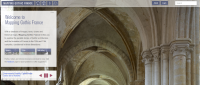
The cover page of the site is neatly designed with all useful menu bar needed in this archive. In the top left of it is the front page, the mapping of the Gothic France, after that gradually we find all the maps of gothic France. The historical essays are in the last. The top right end has the log in option and the search option. While we get into the mapping page we get a list of different options of choice like selecting any particular church, or a number of churches, or select the monograph page of any church, the comparison between different styles of gothic churches. Moreover they also included simulation software of modeling to experiment the structural behavior of arched masonry. The right end of this page has the choice of maps. That means, they have the option to put the churches on different kind of maps of France, like road map, terrain map, satellite map etc.
At this point their limitation of digital archiving came to light. Though they tried to provide two kinds of maps, one historical and one for the present day Europe, but while adding the modern technology to the map, they could not provide the satellite or road network map of the ancient period. As the Google map is widely used for this kind of information, the original site remains weak in this particular area. Probably this is one of the major difficulties of digital humanity to relate the past with the present.
Though this project has open access for its entire viewer, still it has a log in option for the members who can contribute to the development of the site. Again, instead being a historic site this project still kept room for future technological development and addition which is a very positive approach for the project. Overall the project was a well try to accommodate every kind of information to read, understand and perceive the time period, construction system, architecture, socio political scenario of gothic churches in France in medieval period.