Geology, Climate, and Natural Forces
Climate
The region receives about 15 inches of rain and 35 inches of snow annually, and averages 248 sunny days per year. The average high temperature in the warmest month of the year, July, is around 87 degrees, and the average low temperature in January is 17.
The Fountain Creek Watershed
John Wesley Powell, the famous 19th century geologist and explorer, describes a watershed as "that area of land, a bounded hydrologic system, within which all living things are inextricably linked by their common water course and where, as humans settled, simple logic demanded that they become part of a community.” In less poetic terms, a watershed is a region that drains into a river, river system, or other body of water. The Fountain Creek Watershed is a 927-square mile watershed that is located along the central front range of Colorado that drains into the Arkansas River south of the Fountain Valley in Pueblo. The watershed is bordered by the Palmer Divide to the north, Pikes Peak to the west, and a minor divide 20 miles east of Colorado Springs.
The area is characterized by extremes in temperature and precipitation, large elevation changes, steep gradients, diverse ecosystems, and a multitude of water uses. Portions of El Paso, Teller, and Pueblo counties make up the watershed, which encompasses the eight municipalities of Pueblo, Colorado Springs, Fountain, Manitou Springs, Green Mountain Falls, Woodland Park, Palmer Lake, and Monument.
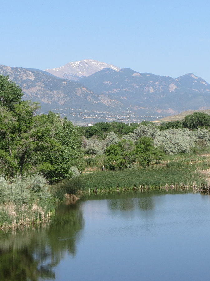
Fountain Creek
Fountain Creek is a 74.5 mile long creek that originates near Pikes Peak in Teller County, and flows through El Paso County to its confluence with the Arkansas River in Pueblo. Fountain Creek's elevation ranges from 14,114 to 4,640 feet from Pikes Peak to where it meets the Arkansas River in Pueblo. It was once known as the Fontaine qui Bouille, "Boiling Fountain," named after a bubbling spring near its headwaters.
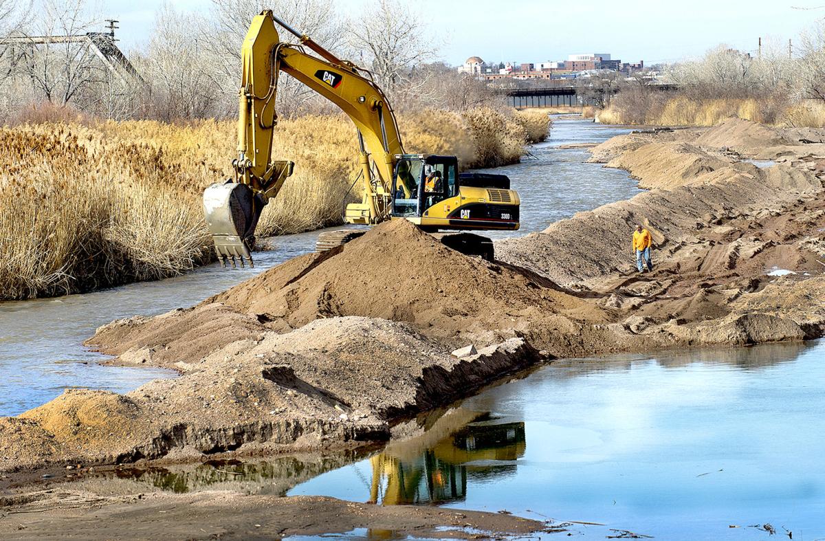
Fountain Creek has drawn humans and animals to the region for thousands of years, including several Native American tribes who travelled along the creek to hunt bison. Following the Colorado Gold Rush in 1859, many failed miners were drawn to a life of farming and ranching, and Fountain Creek was one of the few sources of water that made irrigation possible. But, even as Fountain Creek became the lifeblood of the region's agricultural community, it was also a source of destruction and hardship for many ranchers and farmers. Sometimes the creek runs to less than a trickle causing drought conditions, while at other times it becomes a rushing torrent that consumes hundreds of acres of land at a time. It has been known to destroy entire fields of crops, kill livestock, wipe out fences and roads, and it has even taken entire buildings.
As development upstream from the Hanna Ranch in Colorado Springs has exploded over the past several decades, destruction from the creek has gotten worse. When rain falls on the open prairie it is soaked up by the soil and grass and is eventually deposited into the creek slowly. In the city, however, rain falls on asphalt, concrete, rooftops, and other impermeable surfaces, rushing towards the creek through steel pipes and cement gutters until it collects into one area and flows out of town, towards the communities downstream. So, while the Hanna Ranch and its surrounding neighbors may not receive a single inch of rain, the deluge from upstream might wipe out their land and and cause thousands of dollars in damage. In addition to the farms and ranches in southern El Paso County, stormwater from Colorado Springs has caused damage in Pueblo and other communities along Fountain Creek and the Arkansas River. Colorado Springs is slated to spend $460 million over 20 years on stormwater projects to alleviate runoff, and a lawsuit from the EPA regarding the city's stormwater issues is currently pending.
Fountain Creek
Fountain Creek is a 74.5 mile long creek that originates near Pikes Peak in Teller County, and flows through El Paso County to its confluence with the Arkansas River in Pueblo. Fountain Creek's elevation ranges from 14,114 to 4,640 feet from Pikes Peak to where it meets the Arkansas River in Pueblo. It was once known as the Fontaine qui Bouille, "Boiling Fountain," named after a bubbling spring near its headwaters.
Fountain Creek has drawn humans and animals to the region for thousands of years, including several Native American tribes who travelled along the creek to hunt bison. Following the Colorado Gold Rush in 1859, many failed miners were drawn to a life of farming and ranching, and Fountain Creek was one of the few sources of water that made irrigation possible. But, even as Fountain Creek became the lifeblood of the region's agricultural community, it was also a source of destruction and hardship for many ranchers and farmers. Sometimes the creek runs to less than a trickle causing drought conditions, while at other times it becomes a rushing torrent that consumes hundreds of acres of land at a time. It has been known to destroy entire fields of crops, kill livestock, wipe out fences and roads, and it has even taken entire buildings.
As development upstream from the Hanna Ranch in Colorado Springs has exploded over the past several decades, destruction from the creek has gotten worse. When rain falls on the open prairie it is soaked up by the soil and grass and is eventually deposited into the creek slowly. In the city, however, rain falls on asphalt, concrete, rooftops, and other impermeable surfaces, rushing towards the creek through steel pipes and cement gutters until it collects into one area and flows out of town, towards the communities downstream. So, while the Hanna Ranch and its surrounding neighbors may not receive a single inch of rain, the deluge from upstream might wipe out their land and and cause thousands of dollars in damage. In addition to the farms and ranches in southern El Paso County, stormwater from Colorado Springs has caused damage in Pueblo and other communities along Fountain Creek and the Arkansas River. Colorado Springs is slated to spend $460 million over 20 years on stormwater projects to alleviate runoff, and a lawsuit from the EPA regarding the city's stormwater issues is currently pending.
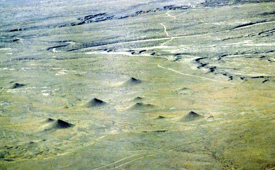
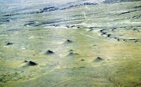
Tepee Buttes
The Tepee Buttes, as their name suggests, are tepee shaped buttes that are scattered throughout the Hanna Ranch and other nearby properties, and are what gives the Buttes region of Southern Colorado its name. These cone-shaped carbonate mounds formed around methane springs and vents on the seafloor of a vast ocean that once stretched from the Gulf of Mexico, through the middle of what is now the United States and Canada, all of the way up to the Arctic Ocean. At the center of each butte is a limestone core partially filled with cemented sand particles, and large "paleocommunities" that surround the limestone cores that once supported them. These paleocommunities consisted of bacteria, algae, and mollusks among other lifeforms. These vents are considered to be relatively rare, and the surrounding Pierre Shale deposits contain fossils from this ancient sea that have been the target of numerous paleontological studies.