The Digital PiranesiMain MenuAboutThe Digital Piranesi is a developing digital humanities project that aims to provide an enhanced digital edition of the works of Italian illustrator Giovanni Battista Piranesi (1720-1778).Works and VolumesGenres, Subjects, and ThemesBibliographyGlossary
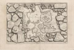
This map is based on an ancient map carved on broken stone tablets known as the Severan Marble Plan. The public display of this map in the early eighteenth century sparked developments in cartography that also led to Giovanni Battista Nolli’s well-known map [image], a remarkably accurate and graphically revolutionary representation of Rome. Nolli’s map is revolutionary for its representation of urban space: black space indicates buildings, and white indicates exterior space. Piranesi contributed the framing vistas. But while Nolli’s map of contemporary Rome uses the more traditional illusion of the two views—the framing vistas and central bird’s eye view—Piranesi’s map of ancient Rome uses a more modern illusion of a printed page displaying fragmented stone. Both present mediated views of Rome’s space, but Piranesi’s insists on the distancing effects of the reproductive image and the dissonance between the historical stone tablet and the contemporary medium of print. Piranesi’s map is also part of an elaborate system of references within his Antichità romane. In the book’s “index,” [image] Piranesi briefly explains the Colosseum’s history and significance next to its number on the Roma map and includes further references pointing to other images [add images] located elsewhere in the volume. To capture Piranesi’s full view of Rome and its monuments, a reader must jump back and forth in this volume, follow numbered references across unnumbered pages, and seek out keys at a great distance from the images they explicate. This presentation of historical place through the heavily-mediated space of the large, illustrated, architectural study seems to combine an idealistic recreation of the lost place of ancient Rome with the present-day efforts embodied in the spatial work that the printed book requires of its users.
NB: there are TWO sets of numbers with two indexes. Each stone fragment in the image is numbered; that index is on digital pp. 57 and 60. The monuments in the map are also numbered; that index is on digital pp. 12-32.