Multispectral Thermal Imager ProjectMain MenuMultispectral Thermal ImagerLA-UR-17-26585Project OverviewMTI OverviewData Processing and AnalysisApplicationsDifferent uses for the data collected by the MTISignificant EventsUnexpected events effecting the functioning of the MTI SatelliteGround Truth MeasurementsMTI Cloud ImagesAtmospheric interference and cloud mask algorithmsCreditsMadeline Whitacreff6e9d0020839762e90346899bb13cc3647ebcbd
Ground Truth Sites and Objectives
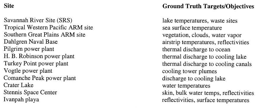
12017-07-06T06:21:54-07:00Madeline Whitacreff6e9d0020839762e90346899bb13cc3647ebcbd197022Sites used for ground truth data collection and the algorithms validated at each siteplain2017-07-06T06:38:10-07:00Madeline Whitacreff6e9d0020839762e90346899bb13cc3647ebcbd
This page is referenced by:
1media/Thermal Images Squaw Creek Reservoir.PNG2017-06-26T15:14:41-07:00Ground Truth Measurements14plain2017-07-25T06:34:24-07:00Several sites were selected to collect ground truth data for the MTI satellite. This data was then used to validate the algorithms used by the MTI.
The algorithms used by the imager were developed primarily by scientists at Los Alamos National Laboratory, while the Savannah River Technology Center was responsible for collecting the ground truth data.
A variety of different ground truth sites were chosen for gathering this data. Sites were chosen based on specific characteristics which could be used to test and validate the MTI algorithms.
The data collected from these sites was used to determine the accuracy of the MTI. The ground truth and MTI data also contributed to other research being conducted at the sites. Further analysis was done on data collected at the Comanche Peak, Pilgrim, and Turkey Point power plants.