Ground Truth Measurements
The algorithms used by the imager were developed primarily by scientists at Los Alamos National Laboratory, while the Savannah River Technology Center was responsible for collecting the ground truth data.
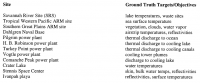
A variety of different ground truth sites were chosen for gathering this data. Sites were chosen based on specific characteristics which could be used to test and validate the MTI algorithms.
The data collected from these sites was used to determine the accuracy of the MTI. The ground truth and MTI data also contributed to other research being conducted at the sites. Further analysis was done on data collected at the Comanche Peak, Pilgrim, and Turkey Point power plants.
- Ground truth collections at the MTI core sites
This page has paths:
- Project Overview Madeline Whitacre