Maps of the City of Long Beach
There are some very different representations of Long Beach through different maps that the city has produced. While it is very hard to have a solid representation of Long Beach because of its vast size, different cartographers have taken different approaches to how they want Long Beach to be represented.
In the Long Beach Tourist Map it is evident that the only areas of the city that are really highlighted are those by the shore, and Downtown Long Beach. These are the areas that hold the main tourist attractions like the Queen Mary, Aquarium of the Pacific, and the many shops and restaurants within the area. This map also indulges into the representation that Long Beach has been trying to project to portray itself as a very 'walkable' city were both residents and tourists can walk to and from their destination. This map is produced by Downtown Long Beach, and it is very evident that they are trying to depict Long Beach as a very cosmopolitan city.
In the next official map, the city is divided by zip codes. I decided to include this map because it really put the city of the city into perspective. While websites and many other indicators announce that Long Beach is very big, but yet the actual distance of the city is very hard to grasp. By splitting up the city into these types of color codes by zip codes, the immensity of Long Beach can be really understood by both residents, locals, and visitors. In a sense when the size of the city is displayed like this, the term "Global-City" is increasingly present because we can now understand just how big the city is.
Critical Maps of Long Beach
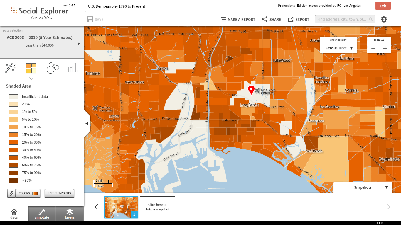
Through Social Explorer I decided to create a map that focused on different aspects of the city that would not be found on a conventional map. I decided to look into the income of the population of Long Beach depending on their location. I chose to have my map indicate those households that are living off with an income of less than $40,000 a year. When analyzing the map, it became very evident that the communities with the lowest income came from East Long Beach, and those who were better off resided in the Western part of Long Beach as well as on the shore facing the beach. While the figure of $40,000 is very well above the poverty line for a standard house of 4 in the United States, I chose this figure because I also wanted to include the middle-class families that reside in the city in my map.
The second Critical Map that I decided to include of the city of Long Beach is the map above that encompasses what I believe to be the most historical and important parts of Long Beach.
- I included the Port of Long Beach because of its significance to making Long Beach a truly "Global City" because of all the economic opportunities that it has brought to Long Beach citizens, and the city itself over the past 100 years.
- I also included schools like Long Beach Polytechnic High School, Long Beach City College, and California State University Long Beach because of the importance of education to a global city. Not only have I repeatedly mentioned the historical significance that Poly High brings to Long Beach but also the potential in academia that it has. Currently, Cal State Long Beach is one of the most competitive CSU's in the state, and that sends the message to the rest of the world that Long Beach as a Global City also cares about its scholars and academia.
-I decided to include classic landmarks like the Queen Mary and the Aquarium of the Pacific because they represent past marine history. As a coastal city the city also experiences a marine culture, and while it has for the most part been catered to please tourists and visitors, it is still important to the city.
-I included Cambodia Town because it is important to recognize one of the strongest Asian-American communities in the city and all of the accomplishments that they have brought into the city and the culture that this community continues to share. -
Last but not least I decided to include the Museum of Latin American Art (MOLAA) because I appreciate how they recognized the achievements of Latinos in a city that also has a predominantly Latino population.
Through this map, I tried to represent what my research has allowed me to explore, and that is the many things that encompass the global city of Long Beach. I felt that all of these factors do encompass the great city that Long Beach is, and while the city and its residents are still continuing to evolve, this is the Long Beach of today.
Background Image:
Pacific Long Beach
WikiCommmons
| Previous page on path | Long Beach, page 4 of 4 | Path end, return home |
Discussion of "Maps of the City of Long Beach"
Add your voice to this discussion.
Checking your signed in status ...