1930 Census Visualization
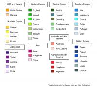
To create this digital visualization, Caroline Luce identified the enumeration districts in the 1930 Federal Census that correspond to districts 4 and 5 in the survey, compiled the data from those census records, and mapped it to explore the demographics of this particular portion of the neighborhood. The points on the map represent individual Heads of Household and the color of the point indicates that individual’s Country of Origin as identified by the census takers. Importantly, the 1930 Federal Census did not explicitly identify Jews, but it did include a category for “Mother Tongue (Native Language),” the listing of Yiddish, Hebrew, or “Jewish” providing an important indicator of Jewish identity, although not an exclusive one. The data reveals not only the neighborhood’s outstanding diversity—with 43 different countries of origins represented in just these two districts—but also the diversity of the Jewish population itself.