Funerary Sculpture of a Bactrian Camel
1 media/Object 5 LACMA bactrian camel_thumb.jpg 2021-04-09T14:57:16-07:00 Curtis Fletcher 3225f3b99ebb95ebd811595627293f68f680673e 39023 3 China, 700-800, molded earthenware in polychrome glaze. plain 2022-03-03T12:13:09-08:00 William Randolph Hearst Collection (46.16.22). Los Angeles County Museum of Art. Curtis Fletcher 3225f3b99ebb95ebd811595627293f68f680673eThis page is referenced by:
-
1
media/Object_5_thumbnail.jpg
2021-04-09T14:42:37-07:00
Funerary Sculpture of a Bactrian Camel
14
See Entry
plain
2022-06-13T13:56:59-07:00
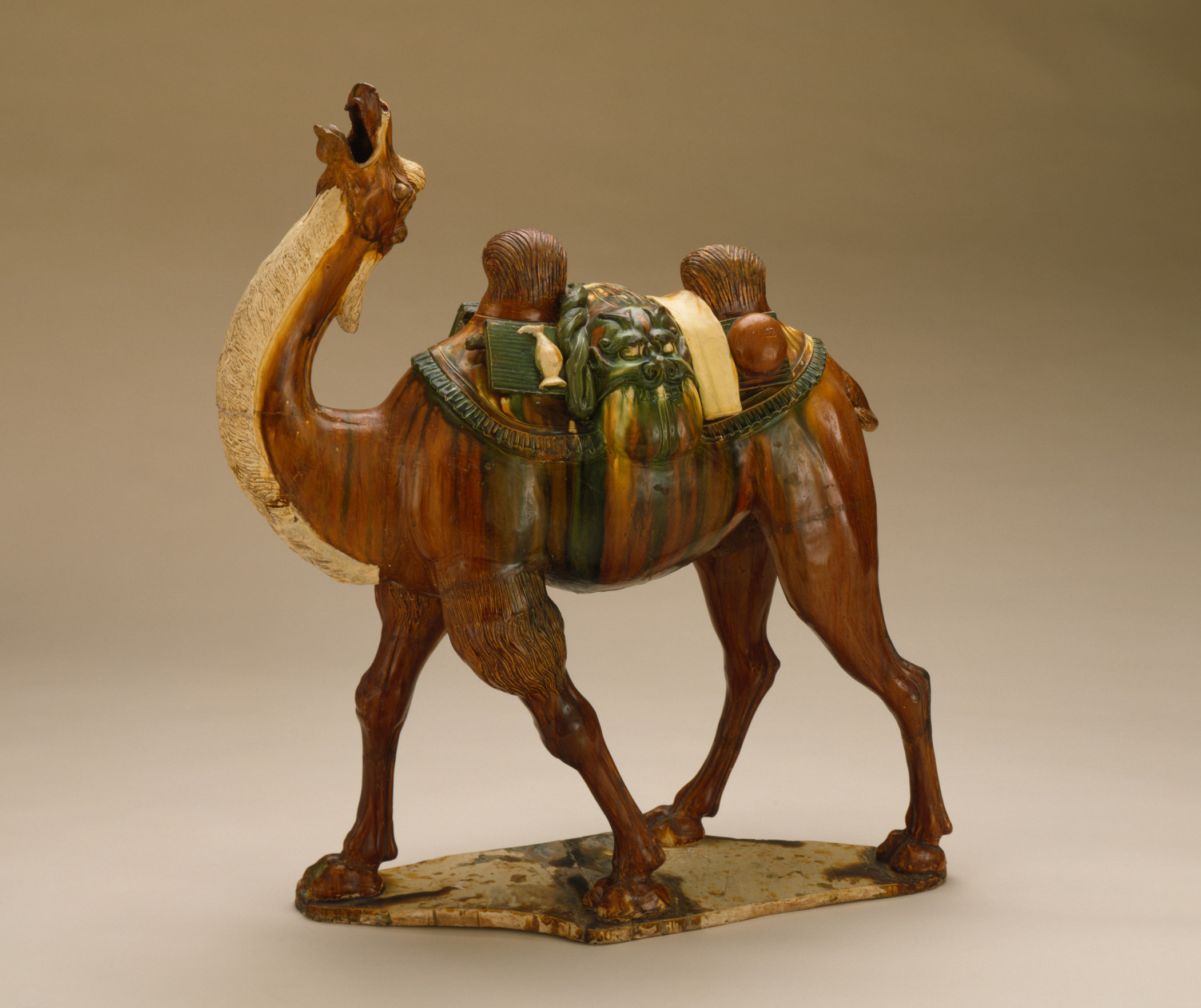
The Tang Dynasty (618–907) marks a golden age in Chinese history. The stability and prosperity that pervaded the country in the first half of the dynasty helped spawn new trends in the visual arts. Some of the works created at that time were preserved in the tombs of the elite, which were discovered in modern times. Particularly significant from these tombs was a type of ceramic sculpture in three colors known as Tang sancai, the Three Colors of the Tang. These pieces reflect not only the tomb culture and ideas about the afterlife in the Tang Dynasty, but also the makers’ superb artistic skills. The Funerary Sculpture of Bactrian Camel now in the Los Angeles County Museum of Art (LACMA) is an exceptional example.
The lively appearance of the camel conjures the vibrancy of commercial and cultural exchanges along the ancient Silk Road, which once connected the Tang capital of Chang’an (today’s Xi’an) with other cities in Central Asia and beyond. The two-humped camel is depicted making bold strides forward, with its head pointing skyward while making a loud cry. It carries on its back bolts of textiles, a water flask, a bowl, and a large sack topped by a grotesque animal mask. Many of these objects are believed to have been made by communities along the Silk Road and traded by Sogdian merchants. Depicting the camel in motion with its back fully loaded underscores the original purpose of the sculpture, namely, to show the camel’s close association with long-distance travels under harsh, uncertain conditions.
The main body of the LACMA camel sculpture is painted in three colors: yellow, green and white. The use of different colors adds vitality to the work, enhancing the realism of the animal. The white manes on its neck, chin, and head contrast sharply with its muscular body that is painted in stripes of brown, green, and yellow. Black vertical stripes are added onto the camel’s torso to create depth in its musculature, thus adding texture to the surfaces of the animal. The cargoes on the back of the camel are mainly in yellow and green. The saddle pad is painted in green, which contrasts with the brown of the camel’s body. On the whole, the glaze is applied across much of the camel body, although parts of the camel such as its head and inner thighs remain unglazed. The purposeful use of colors creates a unique tonal style that is characteristic of the Tang sancai.
The LACMA camel and the long-distance travel that it represents carries historical significance in two ways: first, as a record of the exploration of the Silk Road during the Tang Dynasty; second, as part of the contemporary tomb culture.
In the heydays of the Tang Dynasty, China was the destination for many foreign merchants active along the Silk Road. Not only did they bring luxury goods of all sorts from afar to China, they also supplied Chinese silk textiles to Central Asia and even Europe. The camel was an indispensable means of transportation along the Silk Road. It also became an important theme in the Three Colors of the Tang tradition. The inclusion of three-colored camel sculptures in tombs of the elite in Chinese capitals underscore the widespread awareness of the commercial and cultural exchanges along the Silk Road.
The practice of depositing ceramic sculptures as tomb furnishing had a long history in China. Although little is known about the provenance of the LACMA camel sculpture, a comparison with other similar examples from excavated tombs in Xi’an and Luoyang indicate that it likely came from a lavish burial for a member of the elite class in a capital city during the Tang dynasty. Low-fired ceramic sculptures of various shapes and themes were buried alongside the deceased in decorated subterranean structures made of bricks and stones. By making clay models based on objects from everyone life and placing them inside tombs, the deceased and their living descendent apparently believed that life would somehow continue in the afterlife, so that the comfort and luxury represented in the tomb furnishings could still be enjoyed by the deceased in the world beyond. Bringing the traveling camel into the tomb space is interesting, because its presence suggests a desire by the tomb occupant to explore the Silk Road in the afterlife and perhaps a fantasy about the foreign cultures along the way.
There are other funerary ceramic sculptures in this exhibition that help put the LACMA camel sculpture in context. The Horse and Groom (Entry No. 2) from the USC Pacific Asia Museum, in particular, forms a meaningful comparison. The set of ceramic sculptures was made with the same Tang sancai technique. Like the camel, both figures are closely associated with the cultures along the Silk Road. Standing with both hands raised as if holding onto the reins, the groom has deep-set eyes and a large nose. His outfit was typical of the Sogdians: the cone-shaped hat, an overcoat with lapels, and a large ribbon that wraps around his waist. Similarly, the horse likely came from the Sogdian homeland around the Ferghana Valley, where some of the best horses in the world have been bred. Like the camel, the horse and groom represent long-distance travel that once connected China and the outside world through active commercial and cultural exchanges.
-Shiyun Tang
Further Reading:
Qiqi Jiang, “Tang Sancai” (Ph.D. dissertation, University of Oxford, 2009).
George Kuwayama, Funerary Art of China: Han through T’ang Dynasties (Los Angeles: Los Angeles Museum of Art, 1973).
The Sogdians: Influencers on the Silk Roads. Freer Gallery of Art and the Arthur M. Sackler Gallery, Smithsonian Institutions, Washington D.C. https://sogdians.si.edu/
Daniel C. Waugh, “Horses and Camels,” depts.washington.edu/silkroad/exhibit/trade/horcamae.html
-
1
media/Object_6_thumbnail.jpg
2022-03-03T14:01:41-08:00
The Shāhnāmeh
3
plain
2022-03-04T11:55:36-08:00
Shāhnāmeh or the Book of Kings is an Iranian epic poem that recounts the history of ancient Iran. Of the many settings for the work, the one written by Ferdowsi in 1010 is the most famous, as it offers a cohesive narrative structure to encompass both mythological and historically based stories in some sixty thousand couplets. In the fifteenth century, a Timurid prince named Bāysonghor (1397–1433) commissioned illustrations to accompany Ferdowsi’s setting of the Shāhnāmeh in what came to be known as the Bāysonghori Manuscript, now in the Gulistan Museum in Tehran [1]. If we consider this Shāhnāmeh as a reflection of Persian society in the fifteenth century, we can likewise interpret it as a product of the influences from other cultures along the Silk Road that helped define Persia at that time. Literary historians have already noted the striking similarities in narrative structure that stories in Shāhnāmeh shares with those in Homer’s Iliad, pointing to common Indo-European sources in both works [2]. Pictorial illustrations in the Bāysonghori Manuscript provide another viable venue to examine the cultural interconnections that it exemplifies. Significantly, the Bāysonghori Manuscript boasts illustrations of superior quality, which has made it a masterpiece in the Herat school of miniature painting that is known for its refined brushwork, brilliant colors, and unique spatial perspective.
Evidence of cultural exchange is present in many illustrations that fall under the two major themes in the Shāhnāmeh: the enthronement and battle scenes. Two plates (Object 6A and 6B) best represent the former, whereas Object 6C is a standout of the latter. These three examples show that cross-cultural influences were present during both times of war and of peace.
Object 6A (Plate XXXIII) depicts a Persian ruler watching two people play a game of chess. According to the manuscript, the Shah was challenged by the Raja of India to learn chess. If the Shah did not comply, India would no longer pay tribute to the Shah [3]. One of the Shah’s advisors figured out how to play chess and then challenged the Raja to a new game, backgammon. The cross-cultural dialogue is explicit here: Persia was exchanging games with India. Beyond the scene’s main storyline, there are pictorial details that also demonstrate cross-cultural trade and influence. For one, there are turbans atop every subject’s head. This is in contrast to other scenes that feature the ruler on the throne, in which many people wear Mongol-style hats instead of turbans. The turbans themselves are suggestive of Islamic and South Asian influence at the time. Additionally, there is a person with a darker complexion in the upper right part of the chess audience, who most likely represents the messenger sent by the Raja to the Shah. While the presence of a chess set and a person with darker complexion represent active cross-cultural dialogue, the turbans on many of the subjects’ heads suggest that the practice of wearing them had become mainstream in Persia. Altogether, there were evidently different levels of integration of foreign cultural practices and objects into Persian society at the time.
If Object 6A encapsulates intercultural dialogues between Persia and India, Object 6B (Plate XIX) represents those with East Asia. The scene depicts the legendary ruler Key-Kāvus on a throne enjoying an outdoor gathering full of music, food, and lively conversations. Interestingly, there is a golden Chinese-style table in the foreground of the painting with three Chinese porcelain vases on top. Basil Gray believes that the designs found on these vases such as the two lions playing with streamers on the central vase was based on blue-and-white porcelains of the Ming Emperor Xuande’s reign (1416–1435), which was contemporaneous with the Bāysonghori Manuscript [4]. Since the thirteenth century, trade between Persian and China had increased under the Mongol rule in both countries. Porcelains made in Jingdezhen soon their way into the residences of Persian royalties and aristocrats as tangible symbols of prestige and wealth.
Designs and objects from China are featured equally prominently in battle scenes in the Bāysonghori Manuscript. Object 6C (Plate XXV) depicts another legendary Persian king Key-Khosrow in a clash with Afrasiyab, one of the recurring villains in the Shāhnāmeh who sought to invade ancient Iran on multiple occasions. In this epic battle, a large military banner is hoisted above Key-Khosrow’s army on the left displaying what appears to be Chinese dragons. The design seems to represent the integration of Chinese mythology and its imagery into Iranian culture. The banner is perhaps even a stronger symbol of Chinese influence in Iran than the Chinese vases shown in Object 6B. While the ruler’s possession of these luxury objects represents an association of opulence with Chinese goods, military use of Chinese designs represents their integration into the Persian identity. The depiction of this Chinese-style banner is significant because its association with this foundational story in Persian history suggests that Persians prized the Chinese-style designs enough to identify themselves with them on the battlefield.
In addition to Chinese influences, Object 6C also includes explicit references to European military traditions. Both armies in the composition are utilizing some sort of brass horn, which is more characteristic of battles in Western Europe than in East Asia. Additionally, the shape of the swords appears to be more western. The swords have a cross-shaped hilt, unlike the katanas and other swords of East Asia. The horns resemble early trumpets, which were often used in warfare in Europe. The presence of both the early trumpets and the cross-shaped hilt suggests trade and travel along the Silk Road, as these objects and military technologies they exemplify originated in Europe.
The Bāysonghori Manuscript is both a literary masterpiece and a work of art. Not only does it tell vivid stories about mythical and historical characters in ancient Persia, but it also reveals that people in fifteenth-century Timurid society embraced cultural influences from India, China, and Europe. With a wealth of visual evidence in the illustrations, this manuscript of The Shāhnāmeh of Ferdowsi can be seen as a prized product of the Silk Road and its legacy.
-Koji Sakano and Jayne Hoagbin
[1] Robert Hillenbrand, “Exploring a Neglected Masterpiece: The Gulistan Shahnama of Baysunghur,” Iranian Studies 43, no. 1 (February 2010), 99.
[2] One such example is the story of Hojir in the Shāhnāmeh and that of Helen in the Iliad. See Dick Davis, “In the Enemy’s Camp: Homer’s Helen and Ferdowsi’s Hojir,” Iranian Studies 25, no. ¾ (1992), 17–26.
[3] Gray, An Album of Miniatures and Illuminations from the Bāysonghori Manuscript of the Shāhnāmeh of Ferdowsi, 104–105.
[4] Ibid, 75.
Further Reading:
B. W. Robinson, The Persian Book of Kings: An Epitome of the Shahnama of Firdawsi (London: Routledge, 2013). -
1
media/Object_5_thumbnail.JPG
2022-03-03T13:54:43-08:00
The Travels of Marco Polo
1
plain
2022-03-03T13:54:43-08:00
Over the centuries, no one has encapsulated journeys along the Silk Road or captured the imagination of the world quite like Marco Polo. The Venetian explorer’s journey from his home in Italy through the Middle East and Central Asia to China during the second half of the thirteenth century has earned him worldwide renown, as has his nearly two-decade-long stay in China under the Mongol ruler Khubilai Khan (r. 1279–1294). The 1818 edition of Polo’s memoir The Travels of Marco Polo (Il milione) in the USC Special Collections includes accounts of the explorer’s travels and relationships as well as a detailed fold-out map by James Rennell, an English cartographer and cofounder of the Royal Geographical Society. This map is an exciting visual retelling of Polo’s journey across Eurasia. Notably, the central routes of the Silk Road marking the main thoroughfares between Europe and China as well as Polo’s own path receive the most attention. Likewise, central China is littered with location names and geographic features pertaining to what was at the time the domain of the Yuan Dynasty (1279–1368). On the other hand, there is little to no information given on East Africa, the Arabian Peninsula, Japan, and Korea. This selective detailing is significant for a number of reasons, particularly when compared to other maps of the Silk Road and other editions of Il milione.
As the connection between East and West and the stage on which empires have clashed for centuries, the Silk Road is the source of endless fascination by cartographers. Maps contemporaneous with Rennell’s in The Travels of Marco Polo and those from later times have notable differences that are worth close examination. One such map, Asia and Its Islands by the French cartographer Jean-Baptiste Bourgiugnon D’Anville from 1787, makes a sprawling illustration of the Eurasian landmass in great detail (figure 5.1) [1]. Not only did D’Anville cover far-flung regions in his map, he also stepped back from the local-oriented view to provide visual commentary on the regional realties of the time. For example, colors were utilized in the 1787 map to delineate regions based on political and cultural ties, so that China, Mongol-controlled territory, and Korea were shown as separate entities. In Rennell’s map, however, there are no such distinctions. Nor was there any acknowledgement of the presence of the Yuan Dynasty during Polo’s travels or the cultural makeup of the civilizations along the Silk Road.
There are also noticeable differences between Rennell’s map and later works charting the geography of the Silk Road. Ferdinand von Richthofen’s map from 1877 was the first to apply the term “Silk Road” (die Seidentrasse) to transportation routes connecting the Chinese city of Chang’an (Xi’an) to the eastern regions of Persia (see Entry No. 8) [2]. Richthofen was the first European scholar to seriously use Chinese sources when studying Asian geography, as opposed to relying heavily on works by classical writers such as Ptolemy and Marnius. This approach makes his map unique by taking local knowledge into account. His map also utilizes color to differentiate terrain and climate, thus making it more useful for explorers working in the region than either Rennell’s or D’Anville’s. At the same time, Richthofen failed to show the full extent of the Silk Road as a vital route connecting East and West, a feature which was achieved more effectively by Rennell. In comparison, the Silk Road map reflects the priorities of the time it was produced. The Great Game, a term referring to the power struggles between the Russian and British Empires, dominated the geopolitics in Central Asia in the second half of the nineteenth century. Surveyors used cartography as a means to stake their claim to regional activities. To this end, Richthofen’s map succeeds, but it falls short in terms of capturing the grandeur of the Silk Road on a continental scale.
Examining the Rennell map in The Travels of Marco Polo in light of other survey maps of the region from different time periods underscores its uniqueness in production and aim. Unlike D’Anville’s map of Eurasia, Rennell made no effort to include every detail of the landmass, noting only those that Polo might have traveled through or visited during his decades of exploration across Asia. While Richthofen’s map sought to provide detailed analysis of terrain type, elevation, and transportation routes across the Silk Road, Rennell chose instead to use only labels and clusters of names to form a loose construction of the route across Central Asia. These discrepancies could well be interpreted as inadequacies in Rennell’s map to provide essential information. However, maps like Rennell’s serve a purpose decidedly separate from those from D’Anville and Richthofen in that it was meant for storytelling rather than to disseminate geographical knowledge. The inclusion of places visited by Polo positions the man himself as the subject of the map, not the landmass he traversed. Furthermore, the decision to omit Southern Europe and in particular, Italy, from the map gives another clue to the map’s true purpose.
Polo, a Venetian, began his journey in northern Italy and eventually returned there many years later. The first chapter in the Travels begins in Venice with Polo’s call to adventure and departure from the Italian city. Rennell’s choice to omit Italy thus removes the context of Polo’s early years, transforming him from a Venetian with a specific kind of upbringing and identity into an European broadly speaking. By presenting Polo as a person whose worth is wholly defined by the journey he took, the mapmaker ensured that readers in Europe could relate to and imagine themselves as Polo. In this way, Polo is a stand-in for the readers who, upon starting the book, will soon feel themselves traveling along the Silk Road as Polo did during the thirteenth century. The unique design of Rennell’s map reveals his intention not to provide readers with a tool to travel the Silk Road themselves but rather a guide as they are transported there by Polo. In transforming Polo from a historical figure into a vehicle through which a reader experiences the map and the narrative to follow, Rennell’s map gives Polo an almost mythical quality. The map should therefore be thought of as a literary device that aims to amplify the experience of reading The Travels and elevate Polo’s status among the readers.
The 1818 map by James Rennell stands out as one of the most significant maps to have been published in accompaniment to The Travels of Marco Polo. In a version of the book published in 1908, for example, no such map was included to illustrate Polo’s journey from Venice to Yuan China along the Silk Road. Rennell’s map and the 1818 publication of The Travels of Marco Polo is therefore significant both as a literary work and for its exceptional use of cartography to complement a travel memoir.
-Matt Slade
[1] The full title of D’Anville’s map is Asia and Its Islands according to D’Anville, Divided into Empires, Kingdoms, States, Regions, & ca. with the European Possessions and Settlements in the East Indies and an Exact Delineation of All the Discoveries Made in the Eastern Parts by the English under Captain Cook. It was published in Thomas Kitchin’s General Atlas, Describing the Whole Universe (London: Robert Sayer, 1790), pl. 22–23.
[2] The map was printed in Ferdinand von Richthofen, China: Ergebnisse eigener Reisen un darauf gegründeter Studien (Berlin: D. Reimer, 1877-1912), volume 1. -
1
media/Object_9_thumbnail.JPG
2022-03-03T14:08:38-08:00
The Ruins of Palmyra
1
plain
2022-03-03T14:08:38-08:00
The Ruins of Palmyra was written by Robert Wood and printed in 1753 in London. In this book, Wood documented his journey with James Dawkins and Giovanni Battista Borra to the Mediterranean coast in 1751, during which they visited ancient ruins in Greece, Syria, Palestine, and Egypt. The three men spent the most time in Palmyra taking measurements of artifacts, copying inscriptions, and making detailed drawings of ruined structures and the surrounding landscape, with the hope to rescue what remained of the city from oblivion through their work. The volume that resulted from their labor was considered an elephant folio, meaning that it is a large-size book (measuring 22 inches x 15 inches) and bound by marbled boards covered in calf leather. It is comprised of sixty-two etchings depicting general views of Palmyra as well as architectural elements of select buildings such as the doors, ornaments, and sepulchers. Along with descriptions of what each plate depicts, Wood also describes the current state of the monument at hand and what it might have suffered over time.
The many meticulous, precise architectural drawings in Wood’s The Ruins of Palmyra have made the book an impressive object to behold. The colored, marbled inner covers show how much Wood emphasized the aesthetic appeal of his work. While the overall presentation of the book is stately, the amount of text that accompanies the plates is underwhelming in comparison. A closer examination of the plates gives the impression that The Ruins of Palmyra was conceived as an architectural analysis rather than as a faithful documentation of the site. Tab XIX, for example, depicts two undersides of a roof, showing only the designs as a flat picture (figure 9.1). If Wood’s aim were to accurately represent the buildings both in their past and present forms, he could have offered a more comprehensive discussion of the building, potentially by incorporating diagrams showing from where the piece in question was taken or by noting the proportions of the illustrations relative to the rest of the building. Due to the absence of these details, the plates could easily be misinterpreted and taken out of context. Wood’s true intention, it seems, was to fully restore the glory of each building through reconstruction rather than to faithfully document the structure in its current state.
The publication of Ruins of Palmyra rekindled interest in the ancient city across Europe, luring many to seek out the site themselves. By the mid eighteenth century, Palmyra had evolved for over a millennium an oasis city in the Tadmurean Desert that thrived on trade and cultural exchange between the Mediterranean world and Western Asia. In antiquity, Palmyrene merchants navigated between the Roman and Parthian Empires, bringing goods, ideas, and customs from around the world to the city. They also made their way further east by traveling to the Euphrates from which they rafted downstream to ports connecting with the Indian maritime network [1]. Although they did not travel the overland routes across Central Asia, Palmyrene merchants still managed to import desirable products of the Silk Road trade such as Chinese silk textiles to Syria and across the Roman Empire, as evidenced by the discovery textile fragments from Han-dynasty China in tombs in Palmyra [2].
The Ruins of Palmyra by Robert Wood was not the first publication from Early Modern Europe to recount travels to the Middle East. The Travels of Sir John Chardin into Persia and the East Indies by John Chardin from 1686 was another influential book of the time that gave readers an engrossing account of East-West exchange from a European’s perspective (featured in the Doheny Exhibition) [3]. Written a few decades before Wood’s journey to Palmyra, John Chardin wrote about his voyage from Paris to Isfahan in The Travels. Although these two books cover the same part of the world, the authors focus on subjects in their respective works. Chardin’s book is a personal account of his experience traveling, attempting to collect objects, and participating in high-profile events on behalf of the Parliament of France. Due to the vast array of topics covered in Chardin’s book, the reader is able to learn and develop an opinion about the culture and lifestyle of those residing in Middle Eastern countries. Wood’s book, on the other, amplifies the reader’s curiosity about Palmyra’s ruins and supplies intricate details to help them visualize the past. Chardin’s book captivates the reader, allowing them to fall in love with the people and cultures of the Middle East through his vivid descriptions. However, Wood’s book makes the reader feel nostalgic by presenting them with images of classical monuments as what they might have looked like in their original form through reconstructions.
-Esther Hsu and Hanna Persky
[1] Joan Aruz, Return to Palmyra, Palmyra: Caravan City and Cultural Crossroads, accessed 2022/02/20, https://www.getty.edu/research/exhibitions_events/exhibitions/palmyra/essay.html
[2] Ibid.
[3] John Chardin, The Travels of Sir John Chardin into Persia and the East Indies, the First Volume, Containing the Author’s Voyage from Paris to Ispahan: To Which Is Added, the Coronation of This Present King of Persia, Solyman the Third. (1686). -
1
media/Object_4_thumbnail.jpg
2022-03-03T13:45:48-08:00
Map of Xingqing Palace
1
plain
2022-03-03T13:45:48-08:00
Xingqing Palace was originally constructed in 701 as the residence of five princes in the capital Chang’an under the Tang Dynasty. It became the main residence of Emperor Xuanzong (r. 713–755) in 729. The complex bordered the eastern section of the city wall, just northeast of the city’s main eastern market. It was smaller than the other palaces in the capital at only 1.35 square kilometers compared to the palace city’s 4.2 square kilometers and Daming palace’s 3.11 square kilometers [1].
In this ink rubbing, which is based on an engraved stone stele from 1080, the palace is shown from above, displaying the six outer gates of the palace as well as the seven sections of various sizes within the internal walls. The southern half of the palatial complex were occupied by the Dragon Pond and its grounds. A stream or irrigation ditch crossed the palace from east to west, north of the pond, with a tributary connecting it to the pond. The stele shows eight freestanding buildings within the walls as well as a hall built into the southwest corner of the outer wall. The largest buildings in the palace compound were two halls enclosed by courtyards in the palace’s northwest quarter. Three smaller buildings which might have been open pavilions occupied the grounds of Dragon Pond. Another large hall was just south of the palace’s northern gate, and the northeast quarter was made up of open grounds and two smaller structures. The gates, pond, and buildings were all labeled on the stele.
The stone stele of 1080 was discovered in a fragmentary state in 1934. It purportedly contained the plan of the entire city of Chang’an. This ink rubbing measures approximately 76 cm by 102 cm (30 inches by 40 inches). It was made from a proto-printing technique in which the maker laid a wet piece of paper on the stone, carefully pressing the paper into the depressions of the engraving so as not to break the paper. By letting the paper dry a bit, this allowed the maker to deboss the paper with use of the stone. Next, when the paper was partially dried, the maker would lightly tap the paper with an ink pad, light enough to not darken the debossed sections. When the paper was fully covered with ink, the majority of it would be black while the debossed sections remaining in white lines delineating the map’s images and texts.
To understand the meaning Xingqing Palace had both in its heyday and to later dynasties, it is important to place it in its context of the Tang capital of Chang’an. Although an earlier city near the same site had been one of the capitals of the Han dynasty, Chang’an was reconstructed by the first Sui emperor, Wendi, and further reconstructed under the Tang dynasty. Chang’an was the eastern terminus of the Silk Roads and because of this was home to several ethnic and religious populations. More than one hundred Buddhist monasteries were built in Chang’an along with Daoist, Christian, and Zoroastrian places of worship. The city was constructed near symmetrically in a grid pattern with twenty-five roads running longitudinally, and fourteen roads running latitudinally making it incredibly large. The two main, wide roads running north and south, and east and west of the city were divided into three lanes, with the middle lane exclusively for the imperial family. The city was divided into 110 wards: 108 residential wards and 2 wards that housed markets. The multiple gates leading in and out of the outer wall, and inside and outside of the imperial and palace city walls were reserved for different groups -- whether that be commoners, officials, or the imperial family. From a functional purpose this helped with population control, and government control of commerce in the markets with imperial sanctioned purchasing, selling, and price fixing. Gardens and ponds helped with the distribution of water. From a symbolic perspective, this delineation of specific gates, roads, and wards for specific groups helped inculcate the population into government sanctioned social hierarchies -- this is also seen in the Forbidden City. This helped create the association between city planning and its “associations with strong Chinese-style leadership” [2].
In comparison to other depictions of cities and buildings along the Silk Roads, the map of Xingqing Palace is distinct in both its perspective and the experience it conveys. While they were created hundreds of years after the Xingqing Palace was built, drawings such as Robert Wood’s
illustrations of Palmyra (see Entry No. 9) share some similarities with it. They were all created long after the heydays of the cities they depict and were created from the viewpoint of an outsider looking in. In the case of the Xingqing Palace, these outsiders were artists working for later Chinese dynasties, while Wood was among the Europeans travelling along the Silk Roads. However, while Wood drew from his own perspectives looking up at the monumental ruins of the Silk Road cities, the Xingqing Palace stele was engraved from a perspective looking down on the city. Wood’s illustrations also include indications of scale such as human figures or trees, while the palace stele contains no such indications. While the later depictions of Silk Road cities and ruins emphasize the emotional experience of the locations, the palace stele minimizes it. The Palmyrene illustrations give their locations an otherworldly feeling, almost implying that they could not be matched in the present day of the illustrations. In contrast, the Xingqing Palace stele gives the place a feeling of order and a sense of being ordinary, as far as the palace of the Son of Heaven in the largest city in the world can be ordinary.
The stele depicting Xingqing Palace was carved more than a hundred years after the fall of the Tang dynasty, which raises the question of why later dynasties would want to commemorate the buildings of their predecessors. The stele emphasizes the everyday nature of the palace to make a statement about continuity and improvement between dynasties. The stele indirectly makes the claim that the later dynasties that followed the Tang were capable of matching and exceeding its grand architecture. This bolsters their claim to a continuous Chinese cultural legacy. The European illustrations of Silk Road cities make a claim in the opposite direction. They show the ruined cities as unmatched by following states along the Silk Road, strengthening the European claim to cultural greatness.
The style followed by the stele of displaying the plan of the palace as seen from above is not unique in Chinese cartography. It was often used by later dynasties to display the cities and palaces built by the Sui and Tang [3]. Creating a map of the city from above is akin to creating the city in miniature, and owning a city map is akin to owning the city. This corresponds with the Chinese dynastic habit of displaying the objects of previous dynasties. The image of order that the aerial map creates also serves a political purpose, as legitimizes the current dynasty as the keeper of order in succession to the builders of the city. The true experience of a city like Chang’an may not have matched the order and splendor shown in a display object like the Xingqing palace stele. However, seeing it displayed connected the splendor of the past with the present. The dynasty creating the image declared both that it strove toward the splendor of the great cities of the past and that it could create that splendor. In this way the images served as proxies for architectural drawings of future cities that the authority creating the images hoped to create.
-Ryan Rossio and Omar Kofie
[1] Fu Xinian, Chinese Architecture (Yale University Press, 2016), 104-105.
[2] Nancy S. Steinhardt, Chinese Imperial City Planning (Honolulu: University of Hawaii Press, 1990).
[3] Fu, Chinese Architecture, 99–100.