Roma, Braun Hogenberg
1 media/Roma, Braun-Hogenberg_thumb.png 2021-05-16T09:18:21-07:00 Jeanne Britton e120651dde677d5cf1fd515358b14d86eb289f11 22849 1 from University of South Carolina Digital Collections plain 2021-05-16T09:18:21-07:00 Jeanne Britton e120651dde677d5cf1fd515358b14d86eb289f11This page is referenced by:
-
1
2018-12-03T19:52:03-08:00
Remains of a Covered Portico, or Cryptoporticus, in a villa of Domitian
15
Avanzi d’un portico coperto, o criptoportico, in una villa di Domiziano cinque miglia lontan da Roma su la via di Frascati
plain
2021-05-17T08:06:31-07:00
Title: Avanzi d’un portico coperto, o criptoportico, in una villa di Domiziano cinque miglia lontan da Roma su la via di Frascati Signature: Cavalier Piranesi F(ecit).
Title: Remains of a Covered Portico, or Cryptoporticus, in a Villa of Domitian five miles from Rome on the Via di Frascati Signature: Made by the Knight Piranesi.
In this image, a ruined and precarious entranceway serves as an irregular, jagged frame for a crumbling colonnade. The deep gashes of Piranesi’s etching needle echo those along the severed edges of this ancient remnant. Vines intermingle with gouges in the tufa, which is depicted in almost luminous detail. This structure, which here seems to be on the verge of collapse, no longer exists today. The site is part of the Archaeological Park of the Ancient Appian Way, about 10 km southeast of central Rome, mid-way between Rome and, as Piranesi notes in his caption, Frascati. The Villa of which it was a part was in fact the Villa dei Sette Bassi, one of the largest suburban villas in ancient Rome. Later deemed an entrance door, this structure is not in fact a cryptoportico (a semi-underground passageway whose vaulting supports above-ground structures). In his short volume Di due Spelonche dei ornate dagli Antichi alla Riva del Lago Albano (1762), Piranesi depicts a cryptoportico in two views below: the first is a close-up or large demonstration of the structure labelled “C” in the second, broader view.
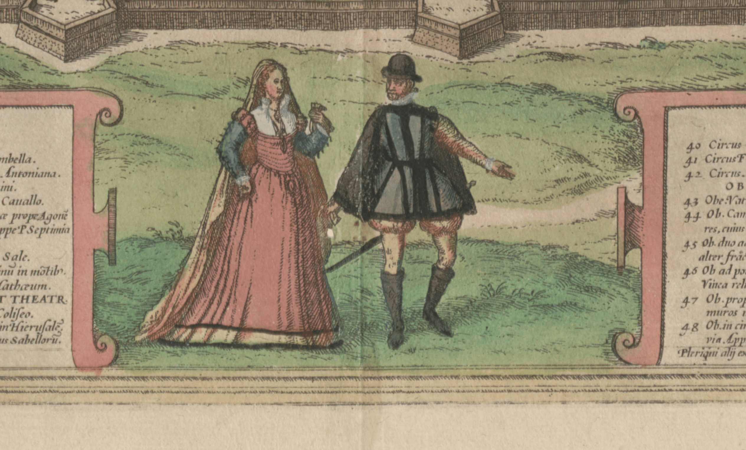
This image from the Views of Rome draws our eyes along an orderly procession of ruined supports towards a distant vanishing point. As if to direct us to look this way, a staffage figure gestures with both arms towards the vanishing point. His position and gesture suggest those of the courtly figures who often populate the foreground of early modern maps that are drawn from an oblique aerial perspective, such as the Braun-Hogenberg map of Rome below.In Piranesi’s view, though, the gesture points not to the glories, whether past or present, of Rome’s urban center, but to the crumbling remains of a suburban villas. Many of the structures on this site are today in poor condition, which is partly due to bombing during WWII (by which time this structure had already collapsed [Hind 60]) but also to inferior building materials. The crumbling, precarious gate could cast the figure’s somewhat cavalier gesture as an expression of the ennobling attitude to ancient ruins that Piranesi and his audience certainly held or an ironic approach to architectural decay. (JB)
To see this image in the Vedute di Roma, vol 16 of Piranesi’s Opere, click here. -
1
2021-08-12T06:52:04-07:00
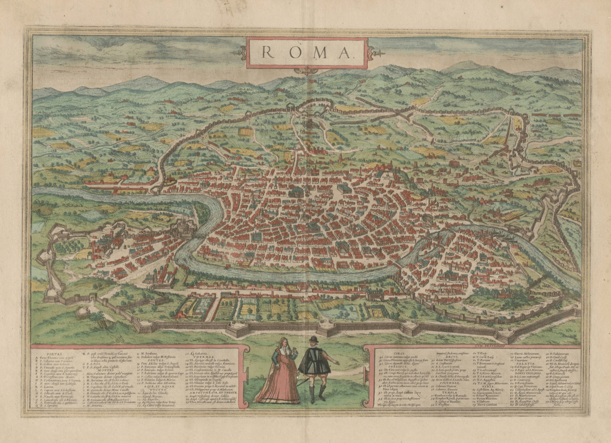
Roma, Cities of the World (Civitates Orbis Terrarum), Georg Braun and Franz Hogenberg, 1572-1617
1
From the John and Mary Osman Braun and Hogenberg Collection
plain
2021-08-12T06:52:04-07:00
This map of Rome comes from a colorful six-volume atlas that represents 475 cities. Pictorial maps, drawn from an oblique aerial perspective, were common during the Renaissance. The bird’s eye perspective presents the entire city in one glance, and the gesture of the fashionable figure on the right suggests that the city is displayed for a viewer’s pleasure. Braun and Hogenberg stated that, “by relying on the subtle sense of vision, … we offer the reader views of cities … that give a much clearer idea than one could obtain from words alone.” This map, like the others in this digital gallery, includes a key identifying monuments such as the Colosseum (37), Pantheon (57), and Castel Sant’Angelo (T). Other than these monuments, however, the architecture lacks any identifying features. While Piranesi’s precise maps resemble archeological or topographical surveys, these maps all suggest that a visual, imaginary depiction of Rome’s architecture and history is more powerful, effective, and accurate than a verbal description.