This path was created by Constance Caddell. The last update was by Jeanne Britton.
The Digital PiranesiMain MenuAboutThe Digital Piranesi is a developing digital humanities project that aims to provide an enhanced digital edition of the works of Italian illustrator Giovanni Battista Piranesi (1720-1778).Works and VolumesGenres, Subjects, and ThemesBibliographyGlossary
Cartography
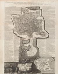
1media/Small map.jpgmedia/Maps banner image smaller.png2017-11-03T11:56:52-07:00Constance Caddelld4428f7815c34c6fd0592b7e434a4fb89d5ca1aa2284945plain2018-02-04T23:46:09-08:00Jeanne Brittone120651dde677d5cf1fd515358b14d86eb289f11Although he is known primarily for his illustrations of Roman ruins, Piranesi also produced many striking and innovative maps of Rome. His "Pianta di Roma e del Campo Marzio," from his Views of Rome, includes an extensive index that refers to plates in his other publications (Antichita Romanae, Campus Martius, and Views of Rome).
Contents of this path:
12018-01-22T12:17:34-08:00Constance Caddelld4428f7815c34c6fd0592b7e434a4fb89d5ca1aa"Plan of Rome and the Campus Martius," from Views of Rome3"Pianta di Roma e del Campo Marzio," from Vedute di Roma (Opere, vol 16)media/map_stitched_compres_jG7R7.jpgplain2018-01-27T19:50:33-08:00Jeanne Brittone120651dde677d5cf1fd515358b14d86eb289f11