This path was created by Constance Caddell. The last update was by Jeanne Britton.
The Digital PiranesiMain MenuAboutThe Digital Piranesi is a developing digital humanities project that aims to provide an enhanced digital edition of the works of Italian illustrator Giovanni Battista Piranesi (1720-1778).Works and VolumesGenres, Subjects, and ThemesBibliographyGlossary
Cartography
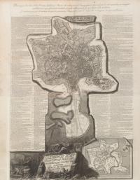
1media/Small map.jpgmedia/Maps banner image smaller.png2017-11-03T11:56:52-07:00Constance Caddelld4428f7815c34c6fd0592b7e434a4fb89d5ca1aa2284937Although he is known primarily for his illustrations of Roman ruins, Piranesi also produced many striking and innovative maps of Rome. His "Pianta di Roma e del Campo Marzio," from his Views of Rome, includes an extensive index that refers to plates in his other publications (Antichita Romanae, Campus Martius, and Views of Rome).plain2018-01-27T00:10:26-08:00Jeanne Brittone120651dde677d5cf1fd515358b14d86eb289f11
Contents of this path:
12018-01-22T12:17:34-08:00Constance Caddelld4428f7815c34c6fd0592b7e434a4fb89d5ca1aa"Plan of Rome and the Campus Martius," from Views of Rome3"Pianta di Roma e del Campo Marzio," from Vedute di Roma (Opere, vol 16)media/map_stitched_compres_jG7R7.jpgplain2018-01-27T19:50:33-08:00Jeanne Brittone120651dde677d5cf1fd515358b14d86eb289f11
This page references:
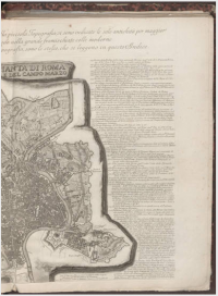
12017-11-09T13:20:57-08:001/4 of v16 map5temporary screenshot (part of map)media/Screenshot from 2017-11-09 16-17-50.pngplain2017-11-15T07:52:58-08:00
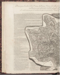
12017-11-10T10:03:17-08:002/4 of V16 map3temporary screenshot (part of map)media/Screenshot from 2017-11-10 13-02-59.pngplain2017-11-15T07:53:47-08:00