Metadata: Mapping Ulysses
This collection of images and video I’ve imported represents a small portion of the archive I have been constructing for my “Mapping Ulysses” project. Ulysses has been mapped countless times with various success rates, but each map consistently mutates the reading experience of the text. Often these mappings of the novel elide the psychogeographic aspect of the novel’s style—mapping aerially also effaces the sociopolitical environment, Bloom's and Stephen’s libidinal investments in space, and the confounding parataxis of local toponyms that work, I think, to disorient readers rather than orient them, etc. In effect, mapping is a totalizing logic that occludes the myriad defamiliarizations and fragmentations attendant to Joyce’s style. The map I propose to build seeks to find a balance between the ineluctable totalizing logic of aerial maps and the psychogeographic defamiliarizations of the novel through a focus on street level social and political relations.
First, I imported a facsimile of a Dublin map from a 1905 street directory, reprinted in David A. Chart’s The Story of Dublin, a dubiously researched history of the city from its medieval establishment to the contemporary Home Rule moment (the book is part of an Edwardian educational series chronicling medieval cities—there is one on Jerusalem, too, Alyssa). I’m searching for a map with better resolution to “warp” for my final visualization (also one that I might attain the rights to—shhh), but this remains the basis for my work for the moment.
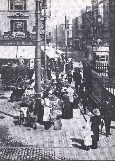
Second, I’ve begun amassing images, constructing an image archive in the hope of marking up the map with images of quotidian Dublin life at the turn of the century. I particularly like this photograph as it deceptively foregrounds class and gender delineations under the guise of urban chaos. The photograph depicts an encounter between the bourgeoisie, who stroll down Sackville Street—the main commercial street of the North Side—with the lower classes who have installed themselves with sales carts along the less prestigious Moore Street. It efficiently exposes gender and class delineations and the spaces of exception where the demarcations blur and bleed into each other. I hope to mark up the map with photos like these, giving it more nuanced, street-level attention.
Third, I’ve embedded a video from British Pathé, an archive of historical newsreel clips that boasts of hosting over 90,000 clips. I similarly strive to mark up my map with this type of documentary (this one is particularly useful in imagining the viceregal procession in "Wandering Rocks").
Dublin Core posed a major learning curve; populating the metadata was a more engaging process than I had originally imagined. Dealing with media that was not “digitally born” to determine the relevant dates proved difficult. For the video of Queen Victoria’s procession, I was unsure whether to include the date of the event, 4 April 1900, or the date of its transformation into a digital object. Dublin Core suggests marking its date of availability, and relegating the date of the event to the “subject” or “coverage” field, yet the archive that hosts the video offers little metadata of this type. The Dublin Core process seems a little muddled when dealing with historical documents, such as this video and the image I uploaded, that are associated with specific dates. The “date” field seems to presume that objects are born digital, and when a document passes into different media, it becomes difficult to map, semantically, each instance of transformation.
I had similar trouble with the “creator” field. I was unsure how to attribute the map—I credited it to Chart, the author of the book from whence it’s cribbed, rather than Dr. Prinsky, who digitized it, though neither is responsible for the map’s creation. These problems, though, are productive ones. I’m committed to thinking that this mapping project might work well as a pedagogical tool, so the discoverability and exportability aspects that Dublin Core appears to privilege strike me as particularly incisive endeavours.
Author: Michael Stevens
Word Count: 660
First, I imported a facsimile of a Dublin map from a 1905 street directory, reprinted in David A. Chart’s The Story of Dublin, a dubiously researched history of the city from its medieval establishment to the contemporary Home Rule moment (the book is part of an Edwardian educational series chronicling medieval cities—there is one on Jerusalem, too, Alyssa). I’m searching for a map with better resolution to “warp” for my final visualization (also one that I might attain the rights to—shhh), but this remains the basis for my work for the moment.
Second, I’ve begun amassing images, constructing an image archive in the hope of marking up the map with images of quotidian Dublin life at the turn of the century. I particularly like this photograph as it deceptively foregrounds class and gender delineations under the guise of urban chaos. The photograph depicts an encounter between the bourgeoisie, who stroll down Sackville Street—the main commercial street of the North Side—with the lower classes who have installed themselves with sales carts along the less prestigious Moore Street. It efficiently exposes gender and class delineations and the spaces of exception where the demarcations blur and bleed into each other. I hope to mark up the map with photos like these, giving it more nuanced, street-level attention.
Third, I’ve embedded a video from British Pathé, an archive of historical newsreel clips that boasts of hosting over 90,000 clips. I similarly strive to mark up my map with this type of documentary (this one is particularly useful in imagining the viceregal procession in "Wandering Rocks").
Dublin Core posed a major learning curve; populating the metadata was a more engaging process than I had originally imagined. Dealing with media that was not “digitally born” to determine the relevant dates proved difficult. For the video of Queen Victoria’s procession, I was unsure whether to include the date of the event, 4 April 1900, or the date of its transformation into a digital object. Dublin Core suggests marking its date of availability, and relegating the date of the event to the “subject” or “coverage” field, yet the archive that hosts the video offers little metadata of this type. The Dublin Core process seems a little muddled when dealing with historical documents, such as this video and the image I uploaded, that are associated with specific dates. The “date” field seems to presume that objects are born digital, and when a document passes into different media, it becomes difficult to map, semantically, each instance of transformation.
I had similar trouble with the “creator” field. I was unsure how to attribute the map—I credited it to Chart, the author of the book from whence it’s cribbed, rather than Dr. Prinsky, who digitized it, though neither is responsible for the map’s creation. These problems, though, are productive ones. I’m committed to thinking that this mapping project might work well as a pedagogical tool, so the discoverability and exportability aspects that Dublin Core appears to privilege strike me as particularly incisive endeavours.
Author: Michael Stevens
Word Count: 660
| Previous page on path | 2. Metadata, page 1 of 8 | Next page on path |

Discussion of "Metadata: Mapping Ulysses"
Add your voice to this discussion.
Checking your signed in status ...