Thanks for your patience during our recent outage at scalar.usc.edu. While Scalar content is loading normally now, saving is still slow, and Scalar's 'additional metadata' features have been disabled, which may interfere with features like timelines and maps that depend on metadata. This also means that saving a page or media item will remove its additional metadata. If this occurs, you can use the 'All versions' link at the bottom of the page to restore the earlier version. We are continuing to troubleshoot, and will provide further updates as needed. Note that this only affects Scalar projects at scalar.usc.edu, and not those hosted elsewhere.
Visualizing Crusoe Main MenuIntroduction: Visualizing CrusoeIllustrations and Depictions of Robinson CrusoeThe Cross Calendar"Evil" and "Good" ListThe "Evil and Good" List That Crusoe Creates Upon the IslandThe JournalTimeline of Events in Robinson CrusoeMap of Robinson Crusoe's VoyageRobinsonade Media GalleryCitation Information for Visualizing CrusoeGiorgina Samira Paiella 85ba2283c689fef8e4189b4706fe3885aa1aed43
Mapping Robinson Crusoe
1media/First-edition-of-Daniel-c_30_f_6_fp_tp-2.jpg2019-05-27T02:29:55-07:00Giorgina Samira Paiella 85ba2283c689fef8e4189b4706fe3885aa1aed433421415plain2019-06-22T22:28:48-07:00Giorgina Samira Paiella 85ba2283c689fef8e4189b4706fe3885aa1aed43Even for those who have not read Robinson Crusoe, most are aware of the central premise of the novel—of a man shipwrecked solo on a deserted island. Central to the castaway narrative is the desert island onto which the survivor washes up. Some of these islands that appear in castaway narratives are purely fictional, but many take their inspiration from real-world uninhabited islands.
Some sources suggest that Daniel Defoe's inspiration for Robinson Crusoe was based on the story of real-life Scottish castaway Alexander Selkirk, who was stranded for four years on the island of Más a Tierra, since renamed Robinson Crusoe Island in 1966. The island is one of three volcanic islands that comprise the Juan Fernández Islands off the coast of Chile. The other two islands are called Alejandro Selkirk Island (formerly "Más Afuera") and Santa Clara Island.
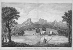
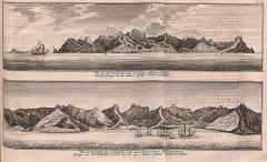
British Commodore George Anson circumnavigated the globe from 1740-1744, and his travels brought him to the Juan Fernández Islands. Some of the engravings in his A voyage round the world, in the years MDCCXL, I, II, III, IV depict what is now known as Robinson Crusoe Island, including engravings of Anson's tent pitched on the island.
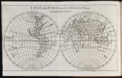
Also in 1719, Daniel Defoe published a sequel to Robinson Crusoe titled The life and strange surprizing adventures of Robinson Crusoe, of York, mariner : who lived eight and twenty years, all alone in an un-inhabited island on the coast of America, near the mouth of the great river of Oroonoque : having been cast on shore by shipwreck, wherein all the men perished but himself : with an account how he was at last as strangely deliver’d by pyrates / written by himself. The text's frontispiece includes a map of the world onto which Crusoe's voyages are overlaid.
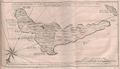
12019-06-16T23:12:04-07:00The Juan Fernández Islands3"A Plan of Juan Fernándes Island in the South Sea" (1747).media/rar5711_taf10.jpgplain2019-06-18T20:10:03-07:00
12019-06-16T22:49:10-07:00Map of the Juan Fernández Islands3"Carte Particuliere de l'Isle de Juan Fernandés Tirée du Voyage de l'Amiral Anson." (1754)media/Isle-de-Juan-Fernand-s-.-Robinson-Crusoe-Island-Juan-Fernandez.-BELLIN-1758-map-[1]-348222-p.jpgplain2019-06-18T20:00:13-07:00