Dutch "Orientalische Indien" (“Little Voyages”), Johann Theodor and Johann Israel de Bry
1 2017-11-13T11:26:18-08:00 Elissa DeFalco e547f2c706898ac61284a88103735048ea3a165e 23125 1 Plate VIII, "Die Insel Madagascar" [1599] plain 2017-11-13T11:26:18-08:00 Elissa DeFalco e547f2c706898ac61284a88103735048ea3a165eThis page has annotations:
- 1 2017-11-14T11:25:26-08:00 Elissa DeFalco e547f2c706898ac61284a88103735048ea3a165e Section marked "The Dutch Graveyard" Elissa DeFalco 8 plain 2017-11-15T08:51:42-08:00 Elissa DeFalco e547f2c706898ac61284a88103735048ea3a165e
- 1 2017-11-14T11:41:27-08:00 Elissa DeFalco e547f2c706898ac61284a88103735048ea3a165e "The Dutch Graveyard" Elissa DeFalco 5 The Dutch Graveyard plain 2017-11-15T08:29:08-08:00 Elissa DeFalco e547f2c706898ac61284a88103735048ea3a165e
- 1 2017-11-15T08:31:54-08:00 Elissa DeFalco e547f2c706898ac61284a88103735048ea3a165e Section B, in the notes below Elissa DeFalco 2 plain 2017-11-15T08:32:33-08:00 Elissa DeFalco e547f2c706898ac61284a88103735048ea3a165e
- 1 2017-11-15T08:31:35-08:00 Elissa DeFalco e547f2c706898ac61284a88103735048ea3a165e Annotation Elissa DeFalco 1 plain 2017-11-15T08:31:35-08:00 Elissa DeFalco e547f2c706898ac61284a88103735048ea3a165e
This page is referenced by:
-
1
media/ESA Madagascar Jellyfish.jpg
2017-10-03T05:24:08-07:00
Madagascar: III
79
Arrivals from Europe
image_header
2018-03-10T21:12:54-08:00
Europeans first charted Madagascar via a wave of Portuguese vessels, exploring the Indian Ocean from 1498. Diego Diaz encountered the island in 1500, and found a native population well-versed in centuries of trade. However, for much of the sixteenth century, European voyages to the island remained largely unintentional, "as their ships landed on the island following harsh storms in the Mozambique Channel. Later voyages were sometimes intended to discover any survivors from shipwrecks" (Hooper 25).
By and large, the Portuguese incursions into Madagascar were focused primarily on conversions. One of the most notable encounters occurred when a local prince named Drian-Ramaka was taken from the island to the Portuguese colony at Goa, to be forcibly educated at a Jesuit mission. His royal parents and their subjects were understandably furious at the Portuguese when he was returned to the island two years later, in 1616, with the expectation that he take part in their conversion efforts on the island. The ombiasa (local spiritual leaders), Drian-Ramaka and the local population then did little to help when as Europeans succumbed to malnutrition and fever. The Portuguese ships eventually abandoned the prince and the island, having converted only one inhabitant, alienated the entire south-eastern Anosy region, and spread an unfounded rumor about the savage nature of the island's inhabitants (Larson, "Colonies Lost", 356-7).
The Portuguese, despite being the first Europeans in the region, were aware of the reality of their limited manpower and naval power. This meant that they "soon realized that they could not compete directly with well-established indigenous merchant networks [and instead,] operating from fortified points around the Indian Ocean littoral, they sought to rake off profits by imposing port taxes, requiring Crown licenses or passports known as cartazes on non-Portuguese merchant vessels, and forcibly inhibiting dangerous rivals that they defined either as 'infidels' or 'pirates'" (Alpers 79-80).
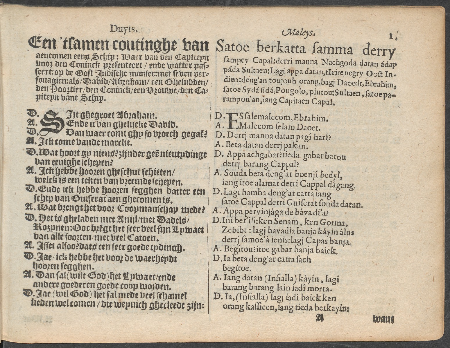
Initially used largely as a base for these doomed religious enterprises, and for resupplying Portuguese ships, the island was subsequently visited by Dutch, French and English forces. The Dutch had similar initial experiences, as disease and low morale took a heavy toll on the crew of their first major expedition in the region. The expedition was marred by a catastrophic casualty rate, violence with both natives in southeast Asia and Portuguese rivals, and commander Frederik de Houtman's subsequent incarceration for two years in Sumatra. Notably, de Houtman did make significant notes on the Malagasy language while visiting the region; merchant-explorers had sought to record useful words in the languages of the region since the middle of the sixteenth century, but his Dialogues in the English and Malaiane Languages was the first published Malay-language group text. It was quickly translated into both Latin and English, providing future expeditions with far greater knowledge of the language and culture.
While results from the "First Dutch Expedition to Indonesia," as it came to be known, were encouraging enough to be cited in the subsequent formation of the Dutch East India Company, maps of the expedition noted the heavy loses, labeling one part of the island "the Dutch graveyard because many of them are buried there."
Once navigational science progressed to the point that Europeans could (relatively) reliably sail naval and merchant vessels into the Indian Ocean, in the seventeenth century, regional exploration and trade exploded. The French attempted to create a colony on the island a few decades after the Portuguese, regularly aggravating and deceiving the local population. Pier Larson explains that to "a significant extent, the chronic cycle of plunder and recrimination between the Atlantic intruders and the people of Anosy [on the SE coast where both the French and Portuguese first settled] stemmed from the exasperating challenges chronically hungry Europeans faced in feeding themselves in a land of seeming plenty when they lacked the local skills and knowledge to thrive" (Ocean of Letters 56).
Etienne de Flacourt was a Frenchman appointed "governor" of the island by the French in 1648, as conflict increased; the previous commander had been deposed and jailed, as the relations with the local Antanosy people were feared to have degraded beyond repair. Flacourt's requests for weapons and reinforcements at Fort Dauphin were refused or ignored for six years, during which time Flacourt applied himself to a study of the local people, flora and fauna of the island. The observations and drawings are some of the first and best records of the natural history of the island, as well as a vital record of early colonial encounters between native people and the imperial forces of the Europeans. [The entirety of his text, in French, is available in digital format in the Contemporary Documents section of this Scalar book.]
James Kay notes that Flacourt's book is notable as, while few European people "had seen Madagascar, even fewer had returned to talk about it, [and] Flacourt provided details of both the natural history, and the culture and history of the southern populations with great authority. As a result, many of his descriptions were of entirely new species" (253). Given that the native Malagasy traditions were largely oral, except for the sorabe ("big writing," Malagasy-language texts kept in Arabic script, of which none are extant from before the mid-eighteenth century), these are the oldest extant, contemporary records of many of the people, flora and fauna of the island.
Due to the French settlers' general inability to survive on the island (and their unwillingness to learn the requisite skills from the native people), Fort Dauphin lost roughly half of its four thousand soldiers and colonists between 1642 and 1674. Kay explains that most most of the survivors moved elsewhere in the Indian Ocean, while those who remained behind on the island were killed when their overly-enthusiastic missionary efforts and need for supplies finally wore out their welcome; the native Malagasy attacked the fort, with sixty-three survivors making it aboard a company ship still in the harbor (58-9). The fear of reprisal from angered Malagasy is another real-world influence that is felt even in the entirely fictional segments of the General History.
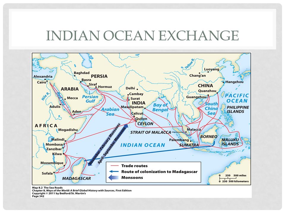
Despite this failure, the strategic importance of the island to the increasingly global network of trade was clear. Jan Hooper notes that, unlike the merchants of the Indian Ocean, Europeans "did not arrive during one season and wait for a change in the monsoon winds to depart again. European arrivals in the ocean were less predictable and required much larger supplies of provisions" so that while scholars generally think of this transformation of "certain food items into commodities, goods with identifiable values and produced for export, as a development of the nineteenth and twentieth centuries," certain items such as "rice reached this state much earlier in provisioning locations such as Madagascar" (9). This shift in the economic further increased the island's importance in the European imagination.
As a result, the European powers came to believe the island was best used for provisioning as opposed to larger-scale colonization. The English continued to fear that the French or another power would once again create a base there from which to establish a chokehold on shipping lanes; however, the distance, climate and lack of political support for such an endeavor meant it remained purely a theoretical issue, regularly debated and dismissed in the European capitals. To contextualize the island's place in global trade, Arne Bialuschewski notes that most ships bound for India and the Far East "sailed on a southerly route and did not call at Madagascar. Ships headed for Muscat, Mocha, or Surat principally put into Cape Town and the Comoros, especially at Anjouan. If a crew ran short of water or provisions, vessels also dropped anchor on the west coast of Madagascar. Homebound ships from India normally passed by the southern tip of the island and stopped for provisions at the Cape ("Pirates, Slavers and the Indigenous Population of Madagascar," 403).
However, interest in the island would continue to grow into the eighteenth century, in no small part due to the increasing pull of the slave trade. While the western coast of Africa is better known for being raided by the European ships, Madagascar's useful location meant it was also pulled into this tragic history; Jane Hooper points out that slave trading never outpaced provisioning as the main European rationale for visiting Madagascar, as "out of the more than eight hundred voyages to the island, only about a third of the English, French and Dutch vessels that stopped there between 1600 and 1800 carried traders in search of slaves. The others loaded valuable supplies of food, wood and water during their stays on the island" (3). Thus a small but truly significant part of the island's history is entwined with this mass forced migration and enslavement.
According to the editor of the Trans-Atlantic Slave Trade Database, "individuals from Madagascar would likely have arrived before 1722. A search of the ships arriving in North America between 1678 and 1721 revealed seven ship disembarkations with a total of 1,922 slaves from Madagascar landing in Virginia: an unnamed one in 1686; Mercury on Feb. 21, 1719; Prince Eugene on Feb. 27, 1719, and again on May 18, 1720; Rebecca on July 13, 1720; and both the Gascoigne and Henriette in 1721" (Gates).
The involvement of Europeans and a new market of far greater mass enslavement appear to have exacerbated existing links to conflict and slavery in the region. Many records of the era refer to existing struggles among the different kingdoms and tribes of Madagascar and the Comoros Islands to the northwest -- including in The General History, as the pirates seek to capitalize on these rivalries. As Randrianja and Ellis note, while it seems a "moot point [...] to determine the extent to which the petty wars noted by early European observers may have been caused at least partly by the Europeans themselves” there is likely a strong correlation (86). The Europeans (first as visitors, then as settlers) launched sudden raids, introduced the island to guns and a far larger and more lucrative market for slavery, and stole grain and cattle when necessary; this must have exacerbated the already significant cyclical rush for supplies on the island “in the hungry period before the harvest” which had previously caused “deaths from hunger far more often than from wounds during times of war” (87).
The late seventeenth century thus saw the pirates, themselves embodying a unique tradition, entering a realm already deep with culture, wealth and violence. By the early eighteenth century, the activities of the island's newest residents, the mostly-English pirates, drew the eye of the Europeans to the island. The ensuing and intoxicating mix of fact and fiction sold many newspapers and novels in this period, and alongside works such as The General History, triggered several subsequent English inspections of the island.
-
1
media/ESA Madagascar Jellyfish.jpg
media/ESA Madagascar Jellyfish.jpg
2017-09-21T10:28:17-07:00
Madagascar (Part II)
58
Navigation of Indian Ocean and Atlantic
plain
2017-12-15T11:13:01-08:00
While the details of initial settlement are still under investigation, it is clear that the Austronesian settlers did mix with the Bantu people of east Africa who had probably long visited the island. The new civilization appears to have thrived, and “By 1100 CE, there was no single region of Madagascar, including the hinterland, whose most favorable points were not occupied, even if the total population of the island remained small” (Randrianja and Ellis 48).
The gradations of genetic heritage within the Malagasy people were visible to early visitors to the island, with the people of the central and northern regions noted as more physically similar to the Indonesian strain of origin and the Malagasy of the western and southern regions more influenced by African ancestors. European visitors sometimes assumed a racial hierarchy based on these differences, but what extant evidence exists suggests that was based more on their own cultural assumptions than any real fact. A "racially diverse population" was thus formed, united by language and "common culture, of which the main features are ancestral veneration [...] the ritual importance of cattle [...] and the construction of rectangular houses" in the Austronesian style (Brown 11-12).
Unique religious culture...writing linked to both Arabic and Indonesia...Encountered Islam but that faded over time. "The Qur'an seems eventually to have been lost. 'The people hold to the law of Mohammed,' noted a sixteenth-century French traveler [...] 'yet they do not worship either God or Mohammed, but the moon'" (Larson 46) ISLAM – part of Islamoc world around ocean… – archaeological record does show presence of Muslim traders after the turn of the first millennia…probably traders coming down the east coast…But older traditions remained, as they were in the liminal spaces of the Muslim world, and merged with some of the basic Muslim ones, which was observed as having “knowledge of the U’ran and of the annual feast of Ramadan” and “they did not eat port and they practiced circumcision” 62
By the time of the European middles ages, the island was already part of the network of shipping in the Indian Ocean, from local trade with the nearby, thriving Swahili coast of Africa to the far reaches of the southeast Asia, despite being located in its furthest western reaches. While luxury goods certainly circulated for centuries, often drawing the interest of contemporary and modern audiences, the circulation of basic supplies for construction and human comfort had created a complex web of trade over the ocean, including Madagascar.
Kings ruled for hundreds of years in manner very similar to those of the Austronesean kings, both in terms of their titles and the their symbols of power.
Met's TOAH
WIKIPEDIA - UP WITH SCHOLARLY WORK This influx of diverse people led to various Malagasy sub-ethnicities in the mid-2nd millennium. The Merina were probably the early arrivals, though this is uncertain and other ethnic groups on Madagascar consider them relative newcomers to the island.[12] The Merina people's culture likely mixed and merged with the Madagascar natives named Vazimba about whom little is known.[13] According to the island's oral traditions, the "most Austronesian looking" Merina people reached the interior of the island in the 15th century and established their society there because of wars and migrant pressure at the coast.[14][15] Merina people were settled in the central Madagascar, formed one of the three major kingdoms on the island by the 18th century – the other two being Swahili-Arab influenced Sakalava kingdom on the west-northwest and Austronesian Betsimisaraka kingdom on the east-northeast.[11][16]
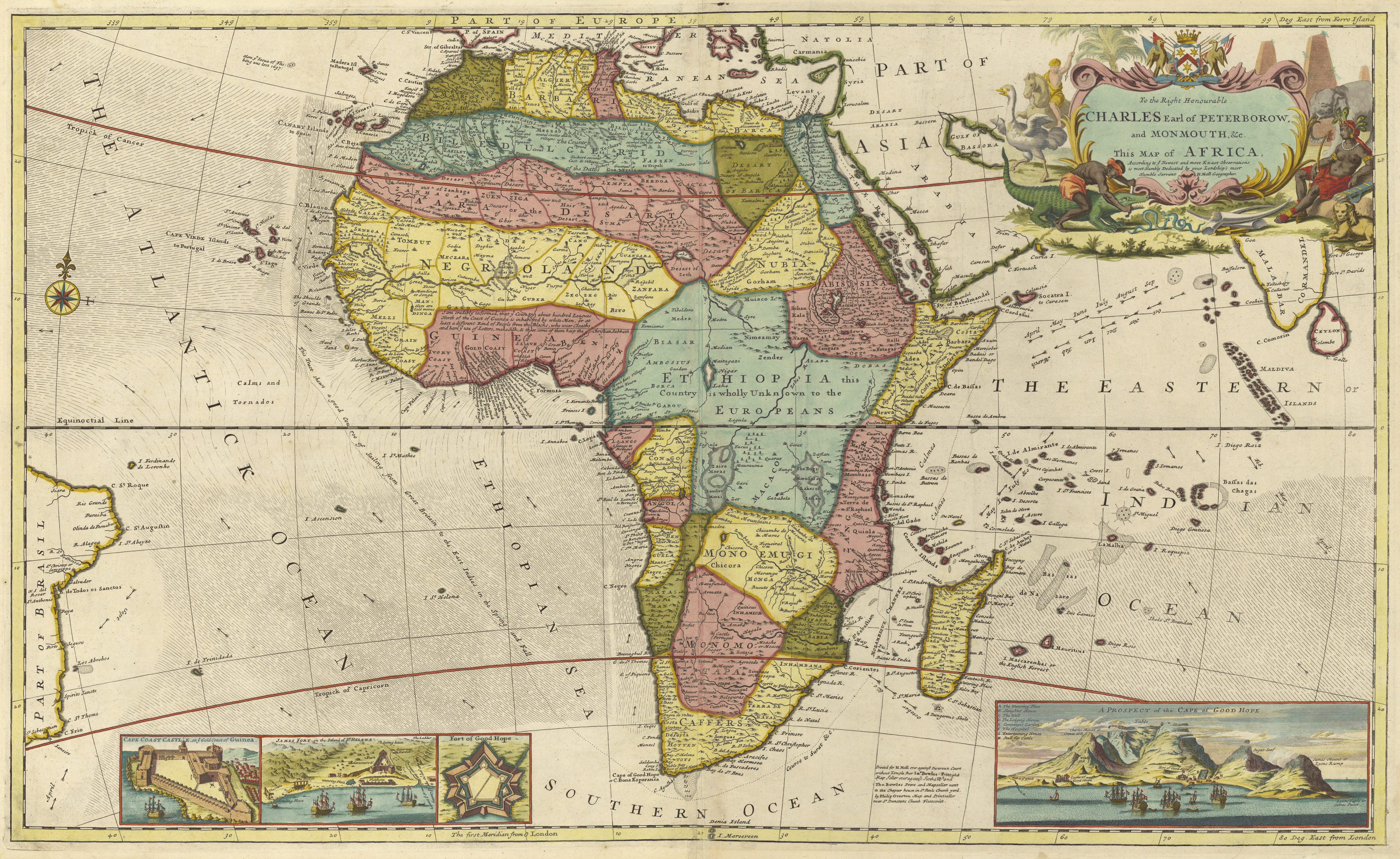
European understanding of physical geography quite good by mid-seventeenth century. Includes understanding of seasonal changes (which will be discussed in more detail in the next chapter). Representative Map. Concepts of Africa; useful visual via the Princeton exhibit that illustrates the changing European understanding of the continent. (Interested readers might enjoy the visual tour, given from-sixteenth to mid-nineteenth centuries, at http://libweb5.princeton.edu/visual_materials/maps/websites/africa/maps-continent/continent.html )
What was lacking, of course, was an equally nuanced understanding of the continent's culture, as European names (and soon, colonies) are mapped over African soil.
Monsoons- general overview with more detail LINK NOT WORKING
http://moocs.southampton.ac.uk/shipwrecks/2014/10/02/maritime-rhythms-indian-ocean-monsoon/
The seasons oceanic and atmospheric shifts due to monsoons made Madagascar an important stop for Europeans navigating their way into the Indian Ocean. As Jane Hooper points out, in Feeding Globalization, despite the island's significant links to the slave trade, "out of the more than eight hundred voyages to the island, only about a third of the English, French and Dutch vessels that stopped there between 1600 and 1800 carried traders in search of slaves. The others loaded valuable supplies of food, wood and water during their stays on the island" (3). These waves of European missionaries, slavers, merchants and pirates that would visit Madagascar, are discussed in Part III of this section.
Europeans first charted the island via a wave of Portuguese vessels, starting in 1498. Diego Diaz stumbled on the island in 1500, and found both supplies and willing native peoples. However, for much of the sixteenth century, voyages to the island remained largely "unintentional, as their ships landed on the island following harsh storms in the Mozambique Channel. Later voyages were sometimes intended to discover any survivors from shipwrecks" (Hooper 25). The Dutch, also among the first Europeans to explore the island, had similar experiences, as disease and low morale took a heavy toll on the crew of their first major expedition in the region. While one of the commanders, Frederik de Houtman, would eventually publish the first European translation of the Malagasy language, the expedition was marred by a fifty-percent casualty rate, violence with natives in southeast Asia and with Portuguese rivals, and Houtman's own incarceration for two years in Sumatra. While results were encouraging enough to be cited in the subsequent formation of the Dutch East India Company, maps of the expedition noted the heavy loses, labeling one part of the island "the Dutch graveyard because many of them are buried there."
AS A RESULT, SEEN LARGELY AS PROVISIONING STATION...PERFECT FODDER FOR PIRATES SEEKING PREY
BUT DECENTRALIZED AUTHORITY
,%20Johann%20Theodor%20%20and%20Johann%20Israel%20de%20Bry.jpg#section-marked-the-dutch-graveyard)
,_1685.jpg)
,%20Johann%20Theodor%20%20and%20Johann%20Israel%20de%20Bry.jpg#the-dutch-graveyard)