Student Research Program
Abstract
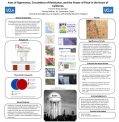
"Axes of Oppression, Circulations of Resistance, and the Power of Place in the Heart of California."By Frances Zamilpa, May 2016
Genevieve Carpio, Faculty Mentor
Maps have been used to settle territorial boundaries, yet maps are not solely scientific. They are also representative documents; an art, that reflects space, but is not space. According to critical cartographers (Manoff, 2014), maps are representative documents in which cartographers select what information and knowledge to display or displace. This provides a theoretical framework to link together geographies of power by examining what is historically represented and excluded in underrepresented and under-resourced communities, like that of Madera, California (Umbach, 1997). Examining the center of California’s heartland and agriculture’s global movement, I will focus on a specific physical dividing location of Madera’s street of Gateway Drive. This particular site’s built environment reflects the circulations of the heart, with a myriad of infrastructures that include Highway 99, the city’s main railroad, traffic lights, crosswalks, shopping and recreational centers, as well as the town’s primary cultural symbol, a water tower displaying the heart of Madera. This forgotten landscape circulates the community’s particular sense of place; the socioeconomic, political, and everyday lived experiences of the community members that populate it. The current scholarship on land use, agriculture, and resources allowed me to critically examine of the ways social justice work can be done in a conservative community, that has little representation of the people who live in it, through creating community-based cognitive and asset maps (Gieseking, 2013).