Section 16 Plat Map
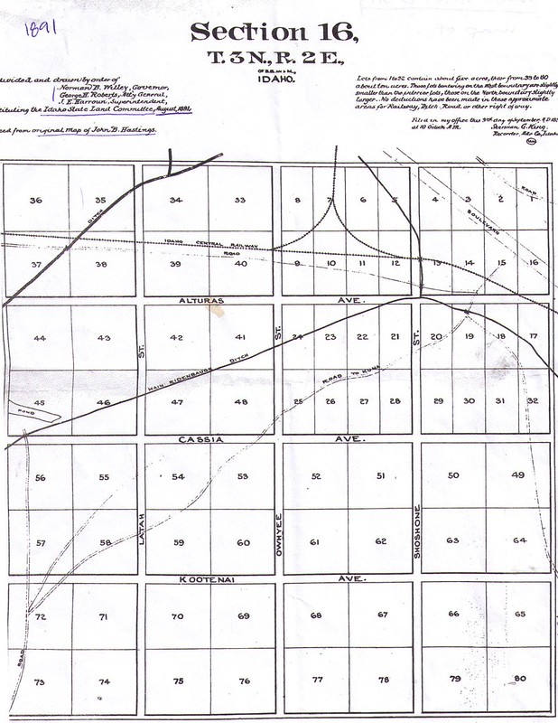
1 media/Section 16 Plat Map 1890_thumb.jpg 2020-05-01T10:45:03-07:00 Angie K. Davis 02665190113c9c0d9cdadb4ac2dc76d0c4f44efb 36140 1 View of Section 16, platted on the Boise Bench in 1891. The square-mile bounded today by Overland Road, Vista Avenue, Roosevelt Street, and the rim of the Bench near the Depot, is known as Section 16 or the State Section. plain 2020-05-01T10:45:03-07:00 Angie K. Davis 02665190113c9c0d9cdadb4ac2dc76d0c4f44efbThis page is referenced by:
-
1
media/1868 USGS_BLM web.jpg
2020-01-20T17:36:35-08:00
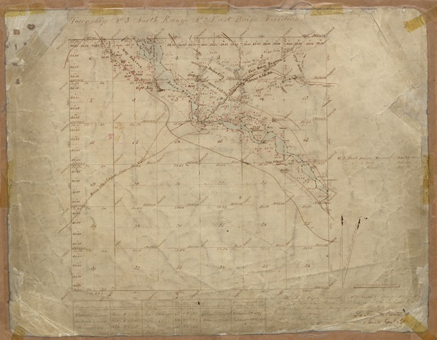
Township 3 North Range 2 East
55
Applying the Land Grid
plain
2022-11-22T08:00:11-08:00
01/28/1868
Late Frontier
Applying the Land Grid
The Public Land Survey System, under the guidance of the Public Land Ordinance of 1785, provided a rational way of measuring, dividing, and selling land obtained by the United States. The survey system organized the continental US into Townships and Ranges, which are measured from an initial survey point. Townships are made up of 36 one-square mile sections of 640 acres and are divided into equal quarters (NW, NE, SE, and SW) of 160 acres. The Homestead Act of 1862 used this standardized form of measurement and division as a foundation for doling out property for settlement. This survey would ultimately define the shape of the communities that develop on the Boise Bench.
When Surveyor General, Lafeyette Cartee, surveyed Township 3 North Range 2 East, in 1868, Boise served as a regional supply point along the Oregon Trail. This snapshot of the Bench matches the historical description of a desert plain crisscrossed by overland trails that were supposedly rife with bandits and indigenous hostiles.
"It is no wonder the people of Boise, after a time, began to look upon their little town as the center of the earth. It was truly a paradise after the long ride over endless sagebrush plains and dusty roads. No matter which way you traveled, it was the same desolate country." Carrie Cartee's letter to Leona Hailey Cartee ("Boise in the Seventies was a Delightful, Gay City Boise" Idaho Daily Statesman, July 23, 1939 p. 10)
In this survey the Owyhee Stage Lines, overland trails, hay and timber reserves, the Boise City Original Townsite Plat, Fort Boise, the Boise River, and the historic river bottoms are visible. This map set patterns for today's streets and roads and established the modern boundaries of the Boise Bench. We can see that the major streets on the Boise Bench conform to the boundaries of the survey conducted by the United States government after Boise was founded.Section 16: State Section
Platted on the Boise Bench in 1891, the square-mile bounded today by Overland Road, Vista Avenue, Roosevelt Street, and the rim of the Bench near the Depot, is known as Section 16 or the State Section. When Idaho became a state in 1890, the federal government designated portions of land, Sections 16 and 36 of every Township and Range, where sales would fund public education.
The original plat map of Section 16 (T3NR2E) named some familiar streets on the Boise Bench. Roosevelt was changed from its original, Ash, and Alturas was changed to Rose Hill, and the East-West Avenues (Kootenai, Cassia, and Alturas/Rose Hill) are presently streets. The Ridenbaugh Canal traversed section 16, making agricultural settlement in State Section possible. By 1903, Kootenai residents had access to the Interurban Trolley via the Ash Street stop on what is now Roosevelt. These features attracted a number of farms and orchards into an area that had once been a desert, and by the 1950s the neighborhoods in Section 16 were metropolitan suburbs for Boise’s growing middle class.
Kootenai is lined with small subdivisions that are named after early residents who started subdividing their land for real estate development, rather than working it agriculturally. Many of the homes on Kootenai were built by local carpenter-builders and lumber companies from the 1930s through the 1960s. Collectively the homes exhibit a range of characteristics, from the picturesque revival of the Spanish and English architectural styles, to the Colonial and Classical, and vernacular cottage designs that were also quite common. Thanks to federal housing policy, the single-family home came to dominate the modern landscape, and the ranch-style home came to represent the new Middle America. Boise’s once agricultural rural outskirts became mid-century suburbs, and home to PTA members, elementary teachers, skilled workers, local corporate managers, executives, and civic leaders that were instrumental in shaping Boise’s metropolitan landscape after World War II.
© Angie K. Davis 2020Return to Timeline 1870-1900
Points of Interest: Township 2 North Range 3 West | Morristown | Morris Hill Cemetery | Boise Depot | Appendices