A Medievalist's Approach to Graphical Display?
As evinced by my Google Earth rendering of the Prologue of the Siege of Jerusalem, premade digital tools do not necessarily provide the best means of representing humanities data, what Drucker labels "capta" in "Humanities Approaches to Graphical Display." [15] Yet in regard to medieval literature, the problem with many visualization techniques lies not in the visual display itself, but with the kind of information taken from the text; that is, in their efforts to limit their research to a "humanities approach," humanities researchers do not necessarily gather the appropriate data from the text. Medieval society was holistic in its approach to science, religion, geography, and literature, which were not separate disciplines but instead different ways to achieve knowledge of God. [16] Medieval poetry is simply one manifestation of the complete medieval worldview.
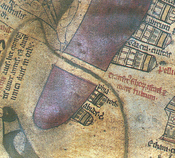
In The Practice of Everyday Life, Michel de Certeau distinguishes between the map ("a plane projection") and the itinerary ("a discursive series of operations") (119), concluding that the two (once simultaneous) forms of representation grew apart with the "birth of modern scientific discourse" in the fifteenth century (120). Medieval maps contained itineraries, and medieval itineraries, whether textual or visual, were also maps. See, for example, this excerpt from a pages-long thirteenth-century itinerary detailing the route from Britain to Jerusalem in Matthew Paris's Chronica Majora (high resolution image available here). Based on a processional rather than bird's-eye-view understanding of space, the map's red text indicates the routes pilgrims to Jerusalem would take. Modern, georeferenced cartographic practice cannot represent this kind of spatiality, which de Certeau links to narrative: "[Stories] traverse and organize places; they select and link them together; they make sentences and itineraries out of them. They are spatial trajectories" (115). [17] Key here is the temporal function of the itinerary, which depicts space as it unfolds in time.
The Siege of Jerusalem functions as a textual map, or rather a text-based itinerary which, like medieval mappa mundi, guides the reader through the narrative history of the city of Jerusalem. Like the typical medieval T and O map, which features Asia at the top of the world, Europe at the bottom, Africa on the right, and Jerusalem in the centre, the Siege recasts the globe as a place of simultaneous historical, biblical, and sacred time, all of which centre on the city of Jerusalem. To the left of this text are two images from the Hereford World Map (England, c. 1300), one of which displays the Red Sea divided by the finger of land by which the Israelites crossed while escaping from Egypt, and the other depicts the Roman Emperor Augustus (who reigned 27 BCE-14 CE) ordering land surveyors to survey the world. [18] A third image from the Ebstorf Map (Germany, 13th century) represents the mythical people believed to live at the southern edge of the world. The digital humanist may not have to reinvent the wheel, so to speak, when it comes to what Drucker labels a "humanities approach" to data visualization. In fact, the answer may be to look back.
Marcia Kupfer compares one’s first encounter with a mappa mundi to reading a foreign language: "medieval spatiality is a dead language, and the 'scientific' form of the earth is too powerful, too pervasive, not to impose itself between our vision and past understanding" (253). The same problem confronts the modern reader of medieval literature. Concepts of time and space are culture- and context-dependent. How might a digital model of time and space in the Siege translate this concept of itinerary into graphical terms contemporary readers can understand?
| Previous page on path | Siege of Jerusalem, page 6 of 11 | Next page on path |
Discussion of "A Medievalist's Approach to Graphical Display?"
Add your voice to this discussion.
Checking your signed in status ...