System History
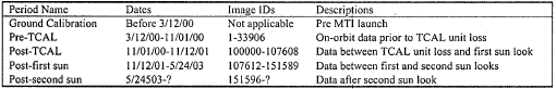
1 2017-07-06T13:08:38-07:00 Madeline Whitacre ff6e9d0020839762e90346899bb13cc3647ebcbd 19702 2 Dates of major events and IDs of images effected plain 2017-07-06T13:12:20-07:00 Madeline Whitacre ff6e9d0020839762e90346899bb13cc3647ebcbdThis page is referenced by:
-
1
media/Focal Plane Assembly.PNG
2017-06-26T15:50:28-07:00
Significant Events
18
Unexpected events effecting the functioning of the MTI Satellite
plain
2017-07-24T07:16:20-07:00
Throughout the duration of the MTI project there have been several events which have, to varying degrees, effected the functions of the satellite. LA-UR-04-3378
Calibration Lamp Failure
After ground calibrations were complete, one of the two calibration lamps on the MTI Satellite failed. This lamp was replaced prior to launching the satellite, and the event is believed to have little to no impact on the system's performance.Memory Module Loss
One week after the launch of the satellite, a short in the system caused the loss of one of the two memory modules aboard the satellite. The satellite was still able to store images using the remaining memory module, however these images had to be compressed. This caused an increase in bit errors in the images. These errors could be identified and impacted only some of the images captured by the MTI.Unplanned Thermal Cycles
There have been four thermal cycles caused by the shutdown of the on-board cryo-cooler. One of these shut downs caused a fuse to blow, leading to the permanent shut-down of the Temperature and Calibration (TCAL) unit. The loss of the TCAL unit led to the shut down of the aperture door assembly and the quick-look calibration wheel assembly. These remained open in their default positions, which allowed for the satellite to continue collecting images. However, it left the optical assembly open and exposed to the environment of space. Without the use of the TCAL unit, the satellite became unable to recalibrate. Without calibration, the accuracy of the information collected by the MTI could not be verified. The satellite lost much of its utility for the purpose of the original mission. The system was still able to image with all of its spectral bands, although it could no longer reliably be used to support nonproliferation efforts. Images taken after this event were used for other applications.Failure of On-Board Gyros
Shortly after installing the Gyro system on the MTI, it was discovered that similar gyro systems had failed on board other satellites and it was likely that the system would not last the duration of the mission. After the gyros were shut down different techniques had to be used to point the imager at its target. To do this scientists created algorithms using solar orientation, magnetic field alignment, and orbital position. Following the shut down of the gyros, the daytime images that the MTI acquired continued to be accurate. Because solar orientation is not possible on Earth's dark side the nighttime images have been more effected by this failure.Sun Looks
Due to the complications caused by the loss of the on-board gyros, orientation of the MTI on the dark side of Earth has become difficult. Without the use of solar orientation, the MTI has to be positioned using magnetic field alignment and orbital position. However, when the satellite is moving over a magnetic pole it can incorrectly calculate its position. Because of this the imager has pointed directly at the sun twice. After each of the sun looks the MTI immediately corrected its position, so only a small area of the focal plane was affected. The areas that were affected by the sun looks were damaged, and some lost function. -
1
2017-07-11T08:52:19-07:00
Image References
12
plain
2017-07-13T08:42:26-07:00
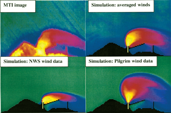
Garrett, Alfred J., et. al. "Comparison of 06/03/00 MTI thermal image of Pilgrim power plant plume to simulated plumes using Pilgrim wind data, National Weather Service wind data and averaged data from the two sources." SPIE Digital Library. July 29, 2001. http://proceedings.spiedigitallibrary.org/proceeding.aspx?articleid=892645
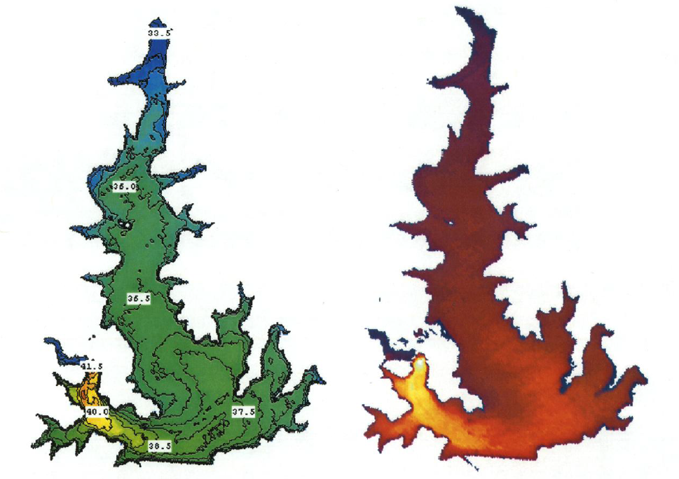
Garrett, Alfred J., et. al. "Calibrated, masked and warped thermal images of Squaw Creek reservoir." SPIE Digital Library. April 16, 2001. http://proceedings.spiedigitallibrary.org/proceeding.aspx?articleid=914113
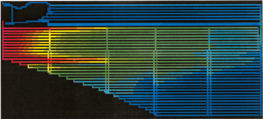
Garrett, Alfred J., et. al. "Simulated thermal image of Turkey Point cooling canals." SPIE Digital Library. July 29, 2001. http://proceedings.spiedigitallibrary.org/proceeding.aspx?articleid=892645
Lawson, S. L., ed. "The MTI image data sets grouped according to changes in the system performance." LANL Research Library. 2004. http://permalink.lanl.gov/object/tr?what=info:lanl-repo/lareport/LA-UR-04-3378
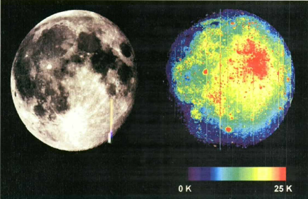
Lawson, S. L., et. al. "MTI 0.88 µm image and relative 8.6 µm brightness temperature map of the lunar surface during total eclipse." LANL Research Library. 2003. http://permalink.lanl.gov/object/tr?what=info:lanl-repo/lareport/LA-UR-03-0430
Nasa Administrator. "Bootprint on the lunar surface." NASA. July 30, 2015. https://www.nasa.gov/mission_pages/apollo /40th/images/apollo_image_11a.html
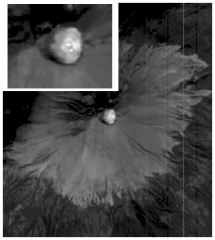
Szymanski, John J., et. al. "December 2000 thermal image taken in MTI band N of Popocatepetl." LANL Research Library. 2001. http://permalink.lanl.gov/object/tr?what=info:lanl-repo/lareport/LA-UR-01-0397
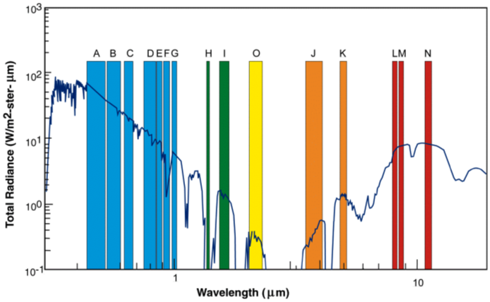
Szymanski, John J., et. al. "MTI spectral bands and superimposed solar spectrum and thermal emission spectrum." LANL Research Library. 2001. http://permalink.lanl.gov/object/tr?what=info:lanl-repo/lareport/LA-UR-01-0397
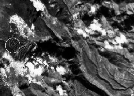
Szymanski, John J., et. al. "Snow on the upper portions of the ski slopes." LANL Research Library. 2001. http://permalink.lanl.gov/object/tr?what=info:lanl-repo/lareport/LA-UR-01-0397
Image References
Hirsch, Karen, et. al. "Flow chart of the MTI simple threshold algorithm." LANL Research Library. 2000. http://permalink.lanl.gov/object/tr?what=info:lanl-repo/lareport/LA-UR-00-2964
Hirsch, Karen, et. al. "The original data is compared with the three cloud masking algorithm results. (a) Shows the actual scene, a portion of flight 95-163 shown in a near infrared band. (b) The MTI cloud masking algorithm results. (c) The MODIS cloud mask results. (d) The GENIE cloud mask results." LANL Research Library. 2000. http://permalink.lanl.gov/object/tr?what=info:lanl-repo/lareport/LA-UR-00-2964
Davis, Anthony B. "Gray-scale version of a 'true color' channel combination of an MTI scene of Los Alamos (NM) in the presence of broken clouds." LANL Research Library. 2002. http://permalink.lanl.gov/object/tr?what=info:lanl-repo/lareport/LA-UR-02-1520
Borel, Chris, et. al. "Block Diagram of the specific implementation of the end-to-end modeling system for the MTI." OSTI. February 1, 1999. https://www.osti.gov/scitech/biblio/7403
Bender, S. C., et. al. "Typical one day ground track +/- 200 kilometers, for MTI's orbit." OSTI. July 7, 1999. https://www.osti.gov/scitech/biblio/8953-ELzDWI/webviewable/
Lawson, S. L., ed. "The MTI focal plane assembly; taken from Rienstra and Ballard." LANL Research Library. 2004. http://permalink.lanl.gov/object/tr?what=info:lanl-repo/lareport/LA-UR-04-3378
Garrett, Alfred J., et. al. "Ground Truth Targets/Objectives." SPIE Digital Library. April 16, 2001. http://proceedings.spiedigitallibrary.org/proceeding.aspx?articleid=914113
Balick, Lee, et. al. "ASTER image of the Mauna Loa summit caldera obtained at 11:21 local time on 14 July, 00." LANL Research Library. 2001. http://permalink.lanl.gov/object/tr?what=info:lanl-repo/lareport/LA-UR-01-1570