Refugio State Beach
Refugio State Beach is most easily accessed from Highway 101’s exit 120. However, one could also hike into the park via a series of paved paths between Gaviota, Refugio, and El Capitan beaches, or bike into the park. The lands surrounding Refugio are mostly agricultural lands. Residential neighborhoods are not identified in the vicinity, thus making motor vehicles the most common transportation mean to access the state beach.
Before colonial contact, Refugio represented an important trade point for Chumash people between communities on the Channel Islands and those in Santa Ynez. Later, in the late 19th and early 20th centuries, Refugio beach was a point of dispute between Spanish explorers and French pirates. It was then bought by a Scottish family who built a private resort on the site. It wasn’t until 1963 that Refugio was classified as a state beach.The Refugio area serves, and has served, as a recreational and commercial space for different groups: recreational for surfers, tourists, and campers; and, commercial for the real estate, agricultural, fishing, and oil industries. Additionally, as a State Beach, Refugio is a site of conservation. As such, nonhuman life and habitat is protected and prioritized. Catching a glimpse of nonhuman life, such as whales and dolphins, is one of the aspects of Refugio that attract tourists and campers.
The first thing that greets visitors at the park’s entry is a state park building where an employee of the park charges visitors a day use, or an overnight camping fee. Once visitors enter the park they circle around on a paved road and end up at the beach day use parking lot, one of two loops of campsites, or a group camp site. Early in the day, the right side of the beach day use parking lot is filled with vans from surfers going directly to the sea.
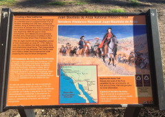
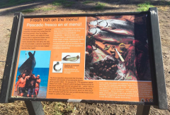
Braving the sour smell of the bathrooms, park visitors can read informational signs about the park’s history, native terrestrial and marine species, conservation, and ‘natural’ tar seepage, as well as the park’s safety indications. These signs are scattered around the park, and acknowledge that the park is Chumash land, though they erase the violence of settler colonialism and instead focus on the drama of the beach’s historical entanglements with piracy and smuggling.
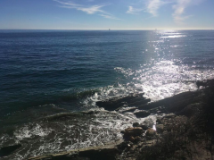
Refugio beach is windswept. The combination of wind, sun, and the glint of light reflecting off the water, leave one feeling visually overwhelmed and slightly stunned. Squinting at the ocean, one sees that the state park forms a bay, ideal for swimming, fishing, and surfing. Sand covers the beach, often dotted with sunbathers. To the right and left of the bay are bluffs. Railroad tracks go along the bluffs, next to the highway, and are the only major sign of industry presence at this site of conservation and recreation.
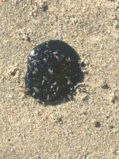
Walking along the sand towards the bluffs on the right of the beach one travels over tar balls, sand fleas, decaying marine grasses, and decomposing kelp. Despite the presence of tacky tar balls on the beach, and offshore oil platforms visible from the shore, the smell of tar is not strong like it is further south on Goleta beaches. Hiking up the bluff on the right of the bay brings us to an expanded view of the ocean, where one might be lucky enough to see migrating whales and playful dolphins, and where one can always see federal offshore oil rigs rising in the distance. Following this same path brings one to the sun-baked railroad tracks with their hot tar scent.
Someone has planted palms along the beach. However, erosion has taken its toll, and some of the palms have fallen and are now partially covered by sand, others are getting ready to fall soon. This causes us to question the park’s cultivated aesthetics of ‘the natural,’ and the palms non-native status.
Back on the beach, facing away from the water, one sees a freshwater estuary. Approaching the freshwater creek, the smell of ocean salt recedes and the scent of brackish water and something fetid fills one’s nostrils. The estuary is full of birds, both sea birds and fresh water birds, and the sound of their squawking and cooing rises above the sound of the waves crashing.
On May 19, 2015, approximately 140,000 gallons of crude oil flowed out of a ruptured Plains All American Pipeline oil pipeline approximately one mile north of Refugio State Beach and into the Pacific ocean. This pipeline spill is the second largest oil spill in the Santa Barbara channel, after the 1969 blowout. The oil injured and killed hundreds of marine animals and affected countless kelp and sea grasses, closed down the fishing industry in the area, and made the California Central Coast’s entanglements with the oil industry violently visible. An alarm that should have alerted operators in Texas of the rupture had been turned off in order for the company to complete other repairs, allowing oil to gush from the ruptured pipe without response. According to the LA Times, from 2006-2015, Plains All American Pipeline accumulated 175 safety and maintenance infractions. The state fish and wildlife officials imposed a ban on fishing grounds in an area of 138 square miles around the spill site. The area under closure represented around a third of the total fishing area for those whose livelihoods depended on grass rockfish and other species that stay close to shore. The Natural Resource Damage Assessment (NRDA) is ongoing at the site until 2019. Part of the NRDA process is accepting local input on restoration ideas. If you have a restoration idea, please visit the online suggestion form here.
MORE on Refugio State Beach:
- Refugio Field Guide: An audio recording created by the Refugio group that the seminar participants listened to during the drive from campus; introduces the listener to Refugio from the perspective of fisherpeople, the oil industry, and non-human life.
- Civil Minutes in Andrews et al. v. Plains All American Pipeline, L.P. et al.: Civil minutes from three hearings between February 2017 and March 2018, wherein the subclasses of the case (fisher and fish industry, oil industry, real property) were certified.
- Natural Resource Damage Assessment Restoration Project: The public has been invited to submit restoration project ideas for Refugio Beach at this link.