Mapping in the Digital Humanities
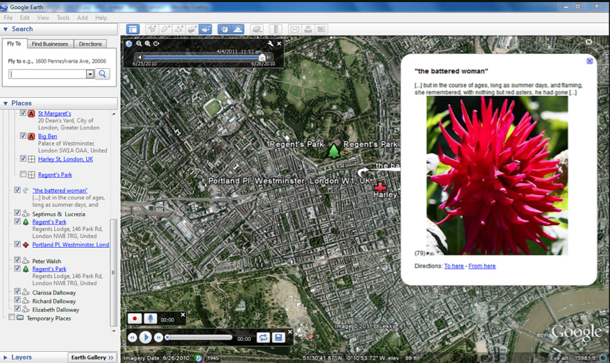
In the past ten years or so, researchers in the digital humanities have taken an interest in digitally modelling the subjective geographies and timelines of documents relevant to humanities research, from conflicting biographical accounts of the life of a historical personage, to the vague notion of the cityscape in a novel. This has resulted in the widespread use of premade cartographic and temporal mapping tools to display time and space visually. In a recent post on ProfHacker, for instance, Erin Sells of Lander University describes an assignment she gave to her undergraduate English students. Using Google Earth software, each student created a detailed, interactive map tracing the paths taken by a character from Virginia Woolf’s Mrs Dalloway. "The abundant detail in the novel and the diverse digital applications in the Google Earth software allowed students to incorporate pictures, sounds, videos, and the text itself into the map," explains Dr. Sells, "[allowing them to create] an exciting visual and spatial representation of the novel, and an exciting new path for teaching and understanding the work of Woolf" (n.pag):
Easy to use and widely available, the web-based Google Maps and the related desktop program Google Earth have dominated spatial modelling in the humanities. [11] But how effectively can this technology portray the complex spatiality of the Siege of Jerusalem? Below is a Google Earth gadget displaying a tour I have programmed to represent the narrative settings of the poem's Prologue, lines 1-188:
Please note that you will need a Google Earth Plug-in to view the map on your browser. Alternatively, you can download the KML file here for better image rendering. Following the precepts of Erin Sells's Virginia Woolf assignment, I have embedded quotations from the text and images of related medieval spatial representations of the city in question (i.e., maps or images of contemporary medieval architecture). Clicking through the placemarks will take the user on a "tour" of medieval Christendom as portrayed in the Siege of Jerusalem, from Christ’s crucifixion just outside the city of Jerusalem, to Titus in Rome, to Vespasian in Galatia, and then to the messenger’s journey across the sea from Syria to Bordeaux. [12]
There are many issues with this visualization of the poem, not the least being the absence of temporal indicators to show how time progresses with the narrative: Placemark 1 to Placemark 2, for example, takes the user from 33 CE to 70 CE in one quick jump. In the recently published "Humanistic Theory and Digital Scholarship," Johanna Drucker dismisses Google Maps and, indeed, "all current information visualization" as "anathema to humanistic thought," which, she argues, should be grounded in qualitative interpretation (86). [13] The satellite images used by Google trick the viewer into accepting the map as "what is," rather than as an interpretation of the spatial relations that constitute the city (86). To add to Drucker's critique, the medieval concept of the earth does not easily render on a twenty-first-century satellite image of the globe. At the time of the Siege of Jerusalem's composition, much of the world, including North America, had not yet been charted by western European cartographers, and the existence of the southern tip of Africa was still subject to debate.
| Previous page on path | Siege of Jerusalem, page 4 of 11 | Next page on path |
Discussion of "Mapping in the Digital Humanities"
Add your voice to this discussion.
Checking your signed in status ...